


 Previous Issue
Display Method:
Articles in press have been peer-reviewed and accepted, which are not yet assigned to volumes /issues, but are citable by Digital Object Identifier (DOI).
Display Method:
, Available online
 Abstract
 FullText HTML
 PDF 2903KB
Abstract:
Sea clutter is a major interference for radar in detecting ocean surface targets, and its intensity and statistical characteristics are jointly constrained by sea state and radar parameters. Focusing on sea clutter intensity (i.e., mean sea surface backscattering coefficient), this paper proposes a near real-time framework for the estimation of global mean sea clutter, which combines multi-source satellite remote sensing sea surface winds with the commonly used geophysical model functions of microwave scatterometry, to achieve higher-precision sea clutter intensity estimation in near real-time and at global scale. Taking the Ku-band and moderate incidence angles as examples, the estimation results are verified using spaceborne scatterometer data from the HY-2 series satellites and the CFOSAT satellite. Consequently, the spatial-temporal distribution and the influencing factors of the relative error in sea clutter estimation are analyzed. The results show that the sea clutter estimations for both VV and HH polarizations are in good agreement with the scatterometer measured data, with relative errors of 1.5~1.8 dB and 2.1~2.4 dB, respectively. The relative error is smaller in summer than in winter, and it is persistently high in low-latitude areas, but varies with seasons in middle and high latitudes. In addition, wind speed and relative wind direction are the main factors modulating the relative error of sea clutter estimation. The model proposed in this paper can be extended to other microwave bands and incidence angles, providing a reliable practical reference for the near real-time estimation of global mean sea clutter.
Sea clutter is a major interference for radar in detecting ocean surface targets, and its intensity and statistical characteristics are jointly constrained by sea state and radar parameters. Focusing on sea clutter intensity (i.e., mean sea surface backscattering coefficient), this paper proposes a near real-time framework for the estimation of global mean sea clutter, which combines multi-source satellite remote sensing sea surface winds with the commonly used geophysical model functions of microwave scatterometry, to achieve higher-precision sea clutter intensity estimation in near real-time and at global scale. Taking the Ku-band and moderate incidence angles as examples, the estimation results are verified using spaceborne scatterometer data from the HY-2 series satellites and the CFOSAT satellite. Consequently, the spatial-temporal distribution and the influencing factors of the relative error in sea clutter estimation are analyzed. The results show that the sea clutter estimations for both VV and HH polarizations are in good agreement with the scatterometer measured data, with relative errors of 1.5~1.8 dB and 2.1~2.4 dB, respectively. The relative error is smaller in summer than in winter, and it is persistently high in low-latitude areas, but varies with seasons in middle and high latitudes. In addition, wind speed and relative wind direction are the main factors modulating the relative error of sea clutter estimation. The model proposed in this paper can be extended to other microwave bands and incidence angles, providing a reliable practical reference for the near real-time estimation of global mean sea clutter.


, Available online
Abstract:
Sound velocity is a core physical parameter in marine acoustic detection and applications, and its accuracy directly determines the reliability of technologies such as underwater acoustic communication, seabed topographic mapping, and acoustic tomography. Currently, sound velocity profiles are primarily obtained indirectly through empirical formulas using Conductivity-Temperature-Depth (CTD) data, among which the Chen-Millero (1977), Del Grosso (1974), and Wilson (1960) formulas are the three most commonly used algorithms globally. However, these formulas were largely developed based on ocean data from mid and low latitudes, and their applicability in the Arctic Ocean—characterized by low temperatures, strong stratification, and significant freshwater input—has not been fully validated. This study utilizes synchronized high-precision CTD and Sound Velocity Profiler (SVP) data collected along the 172°W meridional section east of the Mendeleev Ridge during the 9th Chinese National Arctic Expedition (2018) to systematically compare the computational accuracy of these three algorithms under typical Arctic environmental conditions. The results indicate that along this section, the Del Grosso (1974) empirical formula exhibits the best overall performance, demonstrating the highest accuracy (mean bias of 0.62 m/s) and optimal stability (standard deviation of bias of 0.23 m/s) across the entire section and full depth range, making it the preferred algorithm for regional sound velocity calculation. The Wilson (1960) formula shows a significant depth-dependent systematic overestimation, with a mean bias of 1.17 m/s below 500 m depth, which renders it unsuitable for deep-layer calculations in the Arctic. The Chen and Millero (1977) formula exhibits intermediate overall performance but is sensitive to extreme surface hydrological conditions, with systematic overestimation also occurring in deep layers. The algorithm errors display distinct spatial and vertical heterogeneity that is closely related to the complexity of the hydrological environment, and the unique hydrological processes of the Arctic Ocean significantly amplify the computational uncertainties of existing empirical formulas.
Sound velocity is a core physical parameter in marine acoustic detection and applications, and its accuracy directly determines the reliability of technologies such as underwater acoustic communication, seabed topographic mapping, and acoustic tomography. Currently, sound velocity profiles are primarily obtained indirectly through empirical formulas using Conductivity-Temperature-Depth (CTD) data, among which the Chen-Millero (1977), Del Grosso (1974), and Wilson (1960) formulas are the three most commonly used algorithms globally. However, these formulas were largely developed based on ocean data from mid and low latitudes, and their applicability in the Arctic Ocean—characterized by low temperatures, strong stratification, and significant freshwater input—has not been fully validated. This study utilizes synchronized high-precision CTD and Sound Velocity Profiler (SVP) data collected along the 172°W meridional section east of the Mendeleev Ridge during the 9th Chinese National Arctic Expedition (2018) to systematically compare the computational accuracy of these three algorithms under typical Arctic environmental conditions. The results indicate that along this section, the Del Grosso (1974) empirical formula exhibits the best overall performance, demonstrating the highest accuracy (mean bias of 0.62 m/s) and optimal stability (standard deviation of bias of 0.23 m/s) across the entire section and full depth range, making it the preferred algorithm for regional sound velocity calculation. The Wilson (1960) formula shows a significant depth-dependent systematic overestimation, with a mean bias of 1.17 m/s below 500 m depth, which renders it unsuitable for deep-layer calculations in the Arctic. The Chen and Millero (1977) formula exhibits intermediate overall performance but is sensitive to extreme surface hydrological conditions, with systematic overestimation also occurring in deep layers. The algorithm errors display distinct spatial and vertical heterogeneity that is closely related to the complexity of the hydrological environment, and the unique hydrological processes of the Arctic Ocean significantly amplify the computational uncertainties of existing empirical formulas.


, Available online
Abstract:
Hippocampus erectus is one of the major seahorse species cultured in China. However, high mortality frequently occurs during the feeding transition period, largely driven by fluctuations in water environmental factors. To date, the microecological diversity and water quality characteristics of its culture system remain poorly understood. In this study, cultivation water from H. erectus was investigated across two developmental stages surrounding the feeding transition period, namely the larval stage and adult stage. Growth performance parameters of seahorses and key physicochemical indices of water quality were systematically measured. High-throughput sequencing based on 16S rRNA and 18S rRNA genes was employed to comparatively characterize the community structure and diversity of bacterial and eukaryotic microorganisms, respectively. Furthermore, multivariate statistical analyses were conducted to elucidate the relationships between water quality parameters and microecological communities (represented by bacterial and eukaryotic microbial assemblages). The results showed that ammonia nitrogen (NH3–N) and nitrite nitrogen (NO2-–N) concentrations were significantly higher in the adult-stage cultivation water than in the larval stage. Microecological analysis revealed that photosynthetic autotrophic algae (unclassified_Eustigmatales) and oligotrophic-adapted bacteria (unclassified_Cyanobacteriia) dominated during the larval stage. Following the feeding transition, the eukaryotic microbial community shifted toward stress-tolerant taxa (Oxyrrhis), while the bacterial community transitioned to nitrogen-tolerant and heterotrophic degrading groups (unclassified_Rhodobacteraceae, Lentibacter). These findings demonstrate a clear succession of microbial communities in response to water quality changes during the feeding transition period. This study reveals the changes in the microbial community structure of aquaculture water during the feed transition in the Hippocampus erectus and their correlations with water quality factors. The findings provide a theoretical basis and practical pathways for developing microecological regulation strategies during this period, and contribute to the sustainable development of seahorse aquaculture.
Hippocampus erectus is one of the major seahorse species cultured in China. However, high mortality frequently occurs during the feeding transition period, largely driven by fluctuations in water environmental factors. To date, the microecological diversity and water quality characteristics of its culture system remain poorly understood. In this study, cultivation water from H. erectus was investigated across two developmental stages surrounding the feeding transition period, namely the larval stage and adult stage. Growth performance parameters of seahorses and key physicochemical indices of water quality were systematically measured. High-throughput sequencing based on 16S rRNA and 18S rRNA genes was employed to comparatively characterize the community structure and diversity of bacterial and eukaryotic microorganisms, respectively. Furthermore, multivariate statistical analyses were conducted to elucidate the relationships between water quality parameters and microecological communities (represented by bacterial and eukaryotic microbial assemblages). The results showed that ammonia nitrogen (NH3–N) and nitrite nitrogen (NO2-–N) concentrations were significantly higher in the adult-stage cultivation water than in the larval stage. Microecological analysis revealed that photosynthetic autotrophic algae (unclassified_Eustigmatales) and oligotrophic-adapted bacteria (unclassified_Cyanobacteriia) dominated during the larval stage. Following the feeding transition, the eukaryotic microbial community shifted toward stress-tolerant taxa (Oxyrrhis), while the bacterial community transitioned to nitrogen-tolerant and heterotrophic degrading groups (unclassified_Rhodobacteraceae, Lentibacter). These findings demonstrate a clear succession of microbial communities in response to water quality changes during the feeding transition period. This study reveals the changes in the microbial community structure of aquaculture water during the feed transition in the Hippocampus erectus and their correlations with water quality factors. The findings provide a theoretical basis and practical pathways for developing microecological regulation strategies during this period, and contribute to the sustainable development of seahorse aquaculture.


, Available online
Abstract:
This study investigated the nitrogen input characteristics of submarine groundwater discharge (SGD) and its influence on the nitrogen biogeochemical cycle in the Ria Formosa lagoon system in Faro, southern Portugal, during the early summer season. The results showed that although biogeochemical processes within the subterranean estuary significantly reduce the nitrogen load transported by SGD, it remained an important source of nitrogen nutrients to the lagoon. The SGD-derived nitrate flux into the lagoon was as high as 1.3(±1.0) ×103 kg/d, and the flux of dissolved organic nitrogen (DON) was 220.3(±163.3) kg/d, contributing 89% of the total nitrate input and 37% of the total DON input to the lagoon, respectively. End-member analysis further revealed that approximately 98% of nitrate and 76% of DON originated from freshwater groundwater, highlighting the potential pressure of land-sourced groundwater nitrogen pollution on coastal ecosystems. A 48-hour in situ continuous monitoring in the lagoon revealed that externally sourced nitrate from SGD was rapidly removed from the lagoon system, with a removal rate of 69.9(±68.5) μmol N/(m2·h). Considering the lagoon area, the estimated total daily net nitrate removal in the lagoon is equivalent to 8.9 times the total nitrate input from SGD. This result indicates that the biogeochemical nitrate removal processes within the lagoon are highly active, with a combined removal capacity far exceeding that of the SGD input alone; the lagoon as a whole thus acts as an efficient nitrate sink. Concurrently, the net production rate of DON was as high as 36.3(±35.4) μmol N-DON/(m2·h), indicating that the substantial input of land-sourced nitrate significantly enhanced biological assimilation within the lagoon ecosystem. Therefore, future efforts should prioritize the long-term monitoring and precise management of SGD-derived nitrogen inputs to ensure the health and sustainable development of coastal lagoon ecosystems.
This study investigated the nitrogen input characteristics of submarine groundwater discharge (SGD) and its influence on the nitrogen biogeochemical cycle in the Ria Formosa lagoon system in Faro, southern Portugal, during the early summer season. The results showed that although biogeochemical processes within the subterranean estuary significantly reduce the nitrogen load transported by SGD, it remained an important source of nitrogen nutrients to the lagoon. The SGD-derived nitrate flux into the lagoon was as high as 1.3(±1.0) ×103 kg/d, and the flux of dissolved organic nitrogen (DON) was 220.3(±163.3) kg/d, contributing 89% of the total nitrate input and 37% of the total DON input to the lagoon, respectively. End-member analysis further revealed that approximately 98% of nitrate and 76% of DON originated from freshwater groundwater, highlighting the potential pressure of land-sourced groundwater nitrogen pollution on coastal ecosystems. A 48-hour in situ continuous monitoring in the lagoon revealed that externally sourced nitrate from SGD was rapidly removed from the lagoon system, with a removal rate of 69.9(±68.5) μmol N/(m2·h). Considering the lagoon area, the estimated total daily net nitrate removal in the lagoon is equivalent to 8.9 times the total nitrate input from SGD. This result indicates that the biogeochemical nitrate removal processes within the lagoon are highly active, with a combined removal capacity far exceeding that of the SGD input alone; the lagoon as a whole thus acts as an efficient nitrate sink. Concurrently, the net production rate of DON was as high as 36.3(±35.4) μmol N-DON/(m2·h), indicating that the substantial input of land-sourced nitrate significantly enhanced biological assimilation within the lagoon ecosystem. Therefore, future efforts should prioritize the long-term monitoring and precise management of SGD-derived nitrogen inputs to ensure the health and sustainable development of coastal lagoon ecosystems.


, Available online
Abstract:
Seawater immersion caused by sea-level rise can significantly alter the redox conditions of coastal soils and affect the geochemical processes of iron (Fe) and sulfur (S). To investigate the geochemical response of Fe and S in soils under progressive seawater immersion, a 160-d soil column incubation experiment was conducted using soils with different reactive Fe and organic carbon contents. Seawater table was progressively raised to simulate sea-level rise, and the changes in pore water dissolved Fe (DFe), dissolved sulfide, and solid-phase reactive Fe and sulfide species were analyzed. The results showed that after seawater immersion, DFe concentrations in pore water significantly increased in all soil treatments, while dissolved sulfide remained at relatively low levels overall. In soils with low reactive Fe content, only minor accumulation of total reduced inorganic sulfur (TRIS) occurred in the deeper layers. In contrast, reactive Fe-rich red soil exhibited faster and higher DFe accumulation, as well as more pronounced TRIS accumulation. Higher organic matter content further promoted dissimilatory iron reduction and sulfate reduction, and shortened the initiation time of sulfate reduction. Distinct vertical distributions of DFe and TRIS were observed: DFe concentrations in the middle layer were generally higher than those in the bottom and top layers. TRIS was dominated by elemental sulfur (S0) and acid-volatile sulfide (AVS) in all treatments, with limited formation of pyrite. The different response times of dissimilatory iron reduction and sulfate reduction to seawater immersion, together with the contents of reactive Fe and organic matter, jointly control the transformation and vertical differentiation of Fe and S in soils. Long-term progressive seawater inundation not only shifts the sulfide accumulation layer upward but also weakens the “rusty sink” effect of reactive Fe on organic carbon protection, while simultaneously affecting the chemistry of both groundwater and surface water.
Seawater immersion caused by sea-level rise can significantly alter the redox conditions of coastal soils and affect the geochemical processes of iron (Fe) and sulfur (S). To investigate the geochemical response of Fe and S in soils under progressive seawater immersion, a 160-d soil column incubation experiment was conducted using soils with different reactive Fe and organic carbon contents. Seawater table was progressively raised to simulate sea-level rise, and the changes in pore water dissolved Fe (DFe), dissolved sulfide, and solid-phase reactive Fe and sulfide species were analyzed. The results showed that after seawater immersion, DFe concentrations in pore water significantly increased in all soil treatments, while dissolved sulfide remained at relatively low levels overall. In soils with low reactive Fe content, only minor accumulation of total reduced inorganic sulfur (TRIS) occurred in the deeper layers. In contrast, reactive Fe-rich red soil exhibited faster and higher DFe accumulation, as well as more pronounced TRIS accumulation. Higher organic matter content further promoted dissimilatory iron reduction and sulfate reduction, and shortened the initiation time of sulfate reduction. Distinct vertical distributions of DFe and TRIS were observed: DFe concentrations in the middle layer were generally higher than those in the bottom and top layers. TRIS was dominated by elemental sulfur (S0) and acid-volatile sulfide (AVS) in all treatments, with limited formation of pyrite. The different response times of dissimilatory iron reduction and sulfate reduction to seawater immersion, together with the contents of reactive Fe and organic matter, jointly control the transformation and vertical differentiation of Fe and S in soils. Long-term progressive seawater inundation not only shifts the sulfide accumulation layer upward but also weakens the “rusty sink” effect of reactive Fe on organic carbon protection, while simultaneously affecting the chemistry of both groundwater and surface water.


, Available online
Abstract:
Coastal salt marsh ecosystems exhibit high efficiency in carbon fixation and storage, but they are also non-negligible sources of methane (CH4) emissions. Global Warming Potential (GWP) is an indicator that measures the warming effect of a unit mass of greenhouse gas relative to CO2 over a specific time horizon. The GWP of CH4 over long timescales is significantly higher than that of carbon dioxide (CO2). Therefore, scientific quantification of offset intensity of net ecosystem CO2 uptake by CH4 emissions in coastal salt marshes and accurate determination of ecosystem carbon sink rates are crucial to assess the carbon sink magnitude of blue carbon ecosystems at regional scales. This study employed a combination of techniques, including a “transparent chamber combined with shades of varying light transmittance, trace gas infrared analyzers, and modeling” to conduct high-frequency observations and assessment of the net ecosystem exchange of CO2 (NEE) and ecosystem respiration (ER) in the Cyperus malaccensis salt marsh of the Minjiang River Estuary, simultaneously, also measured the CH4 fluxes , and finally quantified the annual carbon sink rate of the C. malaccensis salt marsh and the offset of net ecosystem CO2 uptake by CH4 emissions. NEE of the C. malaccensis salt marsh exhibited significant seasonal variation, with net atmospheric CO2 uptake occurring in all months. The annual NEE was −5970.2 ± 895.9 g CO2/(m2·a). and the annual CH4 flux was 18.5 ± 0.2 g CH4/(m2·a). Considering theGWP20 and GWP100, the ecosystem carbon sink rates of the C. malaccensis salt marsh were 4543.47 and 5486.8 g CO2-eq/(m2·a), respectively. The offset ratios of net ecosystem CO2 uptake by CH4 emissions were 25.7% and 8.7%, respectively. Although CH4 emissions partially offset the net ecosystem CO2 uptake in the C. malaccensis salt marsh of the Minjiang River Estuary, the C. malaccensis salt marsh ecosystem still exhibits a strong carbon sink function, and plays a significant role in mitigating global climate warming.
Coastal salt marsh ecosystems exhibit high efficiency in carbon fixation and storage, but they are also non-negligible sources of methane (CH4) emissions. Global Warming Potential (GWP) is an indicator that measures the warming effect of a unit mass of greenhouse gas relative to CO2 over a specific time horizon. The GWP of CH4 over long timescales is significantly higher than that of carbon dioxide (CO2). Therefore, scientific quantification of offset intensity of net ecosystem CO2 uptake by CH4 emissions in coastal salt marshes and accurate determination of ecosystem carbon sink rates are crucial to assess the carbon sink magnitude of blue carbon ecosystems at regional scales. This study employed a combination of techniques, including a “transparent chamber combined with shades of varying light transmittance, trace gas infrared analyzers, and modeling” to conduct high-frequency observations and assessment of the net ecosystem exchange of CO2 (NEE) and ecosystem respiration (ER) in the Cyperus malaccensis salt marsh of the Minjiang River Estuary, simultaneously, also measured the CH4 fluxes , and finally quantified the annual carbon sink rate of the C. malaccensis salt marsh and the offset of net ecosystem CO2 uptake by CH4 emissions. NEE of the C. malaccensis salt marsh exhibited significant seasonal variation, with net atmospheric CO2 uptake occurring in all months. The annual NEE was −


, Available online
Abstract:
To address the limited habitat heterogeneity and suboptimal biological attachment capacity of single-material artificial algal reefs in seaweed bed restoration, this study designed a steel-concrete composite artificial algal reef. Twelve replicate reefs were fabricated and deployed in the Mashanli sea area of Rongcheng in August 2021. Attached macroalgae and animals colonizing both materials, as well as key environmental parameters at the reef site, were monitored in November 2021, June 2022, September 2022, May 2023, and August 2023. Results revealed: (1) the two materials differed significant in their macroalgal establishment effects, with the biomass of attached macroalgal on concrete being significantly higher than that attached on steel, reaching 1.7 times that on steel during the entire monitoring period on average (P < 0.05); (2) macroalgal community structure was jointly shaped by seasonality and reef age, progressing from an early Chlorophyta-dominated phase to a late Phaeophyta-dominated phase. Rhodophyta appeared transiently but never established a persistent dominant stage. After 20 months, a stable, top-level community dominated by Undaria pinnatifida emerged (Y = 0.99); (3) the colonization dynamics of attached animals varied significantly between two substrate materials. Specifically the biomass of attached animals on steel substrates was 8.3 times higher than that on concrete substrates (P < 0.05). These results indicate that, within identical reef units, concrete supported greater macroalgal establishment, whereas steel facilitated significantly higher settlement of attached animals. Combining both materials in artificial reef construction yields synergistic benefits: it concurrently promotes macroalgal development and attached animal colonization, thereby achieving functional complementarity, and significantly enhances both the total biomass and taxonomic diversity of sessile organisms. This dual-substrate strategy provides an evidence-based framework for optimizing material selection in artificial algal reef engineering.
To address the limited habitat heterogeneity and suboptimal biological attachment capacity of single-material artificial algal reefs in seaweed bed restoration, this study designed a steel-concrete composite artificial algal reef. Twelve replicate reefs were fabricated and deployed in the Mashanli sea area of Rongcheng in August 2021. Attached macroalgae and animals colonizing both materials, as well as key environmental parameters at the reef site, were monitored in November 2021, June 2022, September 2022, May 2023, and August 2023. Results revealed: (1) the two materials differed significant in their macroalgal establishment effects, with the biomass of attached macroalgal on concrete being significantly higher than that attached on steel, reaching 1.7 times that on steel during the entire monitoring period on average (P < 0.05); (2) macroalgal community structure was jointly shaped by seasonality and reef age, progressing from an early Chlorophyta-dominated phase to a late Phaeophyta-dominated phase. Rhodophyta appeared transiently but never established a persistent dominant stage. After 20 months, a stable, top-level community dominated by Undaria pinnatifida emerged (Y = 0.99); (3) the colonization dynamics of attached animals varied significantly between two substrate materials. Specifically the biomass of attached animals on steel substrates was 8.3 times higher than that on concrete substrates (P < 0.05). These results indicate that, within identical reef units, concrete supported greater macroalgal establishment, whereas steel facilitated significantly higher settlement of attached animals. Combining both materials in artificial reef construction yields synergistic benefits: it concurrently promotes macroalgal development and attached animal colonization, thereby achieving functional complementarity, and significantly enhances both the total biomass and taxonomic diversity of sessile organisms. This dual-substrate strategy provides an evidence-based framework for optimizing material selection in artificial algal reef engineering.


, Available online
Abstract:
[Background] Summer fishing moratorium system is one of the important systems in the conservation of marine fishery resources in China. [Aim] To explore the spatial-temporal distribution characteristics of light fishing boats in the northern South China Sea after Summer fishing moratorium and assess the impact of Summer fishing moratorium adjustment on light fishery, [Method] based on NPP-VIIRS data from 2012 to 2024, we analyse of light fishing boats aggregation distribution characteristics, operation center of gravity changes and light radiation changes with time characteristics of three months after the end of Summer fishing moratorium. [Result] We found that (1) In the first month after Summer fishing moratorium, there are one aggregation area of light fishing boats in the East Hainan Island, 5,178.53 km2 and 2,609.70 km2 in the West Guangdong Province and the Pearl River estuary, respectively; there are two gathering areas in the coastal waters of East Guangdong Province, with an area of 687.79 km2 and 2,596.00 km2 respectively. (2) In the first month after Summer fishing moratorium, there were 7 grids in the high frequency region (448~711) and 10 grids in the middle frequency region (315~448); in the second month, the high frequency region disappeared, only 1 grid in the middle frequency region, and the grids in the low frequency region (181~315) and the extremely low frequency region (61~181) increased to 13 and 36 (an increase of 30% and 24.14%); in the third month, the grids in the frequency region (61~181) decreased to 9. (3) After Summer fishing moratorium, the change range of gravity center of the four main light fishing grounds in East Hainan Island, West Guangdong, Pearl River estuary and East Guangdong changed by (110.51~110.81°E, 18.59~19.02°N)、(111.78~112.09°E, 20.94~21.23°N)、(113.94~114.07°E, 21.55~22.08°N) and (116.69~117.01°E, 22.58~22.78°N). The light radiation values of the four fishing grounds reached the peak values on the 19th, 2nd, 14th and 35th days after Summer fishing moratorium, respectively, and the high values of the fishing intensity lasted to 55 days, 54 days, 51 days and 47 days respectively.(4) BSTS model shows that delaying fishing time after 2017 has significant effect on increasing fishing effort of light fishery in Pearl River Estuary fishing ground (P <0.01), the fishing effect on fishing grounds of East Hainan Island, West Guangdong and East Guangdong was not significant. This research can provide reference materials for improving Summer fishing moratorium system and light fishery management in China.
[Background] Summer fishing moratorium system is one of the important systems in the conservation of marine fishery resources in China. [Aim] To explore the spatial-temporal distribution characteristics of light fishing boats in the northern South China Sea after Summer fishing moratorium and assess the impact of Summer fishing moratorium adjustment on light fishery, [Method] based on NPP-VIIRS data from 2012 to 2024, we analyse of light fishing boats aggregation distribution characteristics, operation center of gravity changes and light radiation changes with time characteristics of three months after the end of Summer fishing moratorium. [Result] We found that (1) In the first month after Summer fishing moratorium, there are one aggregation area of light fishing boats in the East Hainan Island, 5,178.53 km2 and 2,609.70 km2 in the West Guangdong Province and the Pearl River estuary, respectively; there are two gathering areas in the coastal waters of East Guangdong Province, with an area of 687.79 km2 and 2,596.00 km2 respectively. (2) In the first month after Summer fishing moratorium, there were 7 grids in the high frequency region (448~711) and 10 grids in the middle frequency region (315~448); in the second month, the high frequency region disappeared, only 1 grid in the middle frequency region, and the grids in the low frequency region (181~315) and the extremely low frequency region (61~181) increased to 13 and 36 (an increase of 30% and 24.14%); in the third month, the grids in the frequency region (61~181) decreased to 9. (3) After Summer fishing moratorium, the change range of gravity center of the four main light fishing grounds in East Hainan Island, West Guangdong, Pearl River estuary and East Guangdong changed by (110.51~110.81°E, 18.59~19.02°N)、(111.78~112.09°E, 20.94~21.23°N)、(113.94~114.07°E, 21.55~22.08°N) and (116.69~117.01°E, 22.58~22.78°N). The light radiation values of the four fishing grounds reached the peak values on the 19th, 2nd, 14th and 35th days after Summer fishing moratorium, respectively, and the high values of the fishing intensity lasted to 55 days, 54 days, 51 days and 47 days respectively.(4) BSTS model shows that delaying fishing time after 2017 has significant effect on increasing fishing effort of light fishery in Pearl River Estuary fishing ground (P <0.01), the fishing effect on fishing grounds of East Hainan Island, West Guangdong and East Guangdong was not significant. This research can provide reference materials for improving Summer fishing moratorium system and light fishery management in China.


, Available online
Abstract:
Black carbon (BC), an inert organic carbon primarily produced by the incomplete combustion of fossil fuels or biomass, constitutes an important stable carbon sink when buried in marine sediments. Current research on sedimentary BC largely focuses on muddy or sandy deposits, while highly calcareous coral sands have received limited attention. In this study, using hydrochloric acid pretreatment to remove carbonate interference, the benzene polycarboxylic acid (BPCA) molecular marker method was applied to systematically investigate the occurrence characteristics of BC in coral sands from the nearshore Weizhou Island and the offshore Yongle Atoll in the South China Sea. The results demonstrate that BC is ubiquitous in coral sands. The BC content at Weizhou Island is significantly higher than at Yongle Atoll, exhibiting a spatial pattern of being higher in nearshore and lower in offshore areas, which indicates that terrestrial input is the dominant source of BC at Weizhou Island. BPCA composition reveals that biomass burning serves as a regional background source affecting both areas; however, influenced by nearshore anthropogenic activities, Weizhou Island is superimposed with strong high-temperature combustion inputs, such as fossil fuels, resulting in a higher degree of aromatic condensation. Grain-size analyses suggests a dynamic behavior characterized by “initial release followed by re-adsorption” of BC during the fragmentation of coral sands. This study demonstrates that coral sands serve as an effective burial medium for BC. Preliminary estimates indicate substantial black carbon sequestration fluxes, which is of great significance for comprehensively evaluating the carbon sink function of coral reef ecosystems.
Black carbon (BC), an inert organic carbon primarily produced by the incomplete combustion of fossil fuels or biomass, constitutes an important stable carbon sink when buried in marine sediments. Current research on sedimentary BC largely focuses on muddy or sandy deposits, while highly calcareous coral sands have received limited attention. In this study, using hydrochloric acid pretreatment to remove carbonate interference, the benzene polycarboxylic acid (BPCA) molecular marker method was applied to systematically investigate the occurrence characteristics of BC in coral sands from the nearshore Weizhou Island and the offshore Yongle Atoll in the South China Sea. The results demonstrate that BC is ubiquitous in coral sands. The BC content at Weizhou Island is significantly higher than at Yongle Atoll, exhibiting a spatial pattern of being higher in nearshore and lower in offshore areas, which indicates that terrestrial input is the dominant source of BC at Weizhou Island. BPCA composition reveals that biomass burning serves as a regional background source affecting both areas; however, influenced by nearshore anthropogenic activities, Weizhou Island is superimposed with strong high-temperature combustion inputs, such as fossil fuels, resulting in a higher degree of aromatic condensation. Grain-size analyses suggests a dynamic behavior characterized by “initial release followed by re-adsorption” of BC during the fragmentation of coral sands. This study demonstrates that coral sands serve as an effective burial medium for BC. Preliminary estimates indicate substantial black carbon sequestration fluxes, which is of great significance for comprehensively evaluating the carbon sink function of coral reef ecosystems.


, Available online ,
doi: 10.12284/hyxb2025006
Abstract:
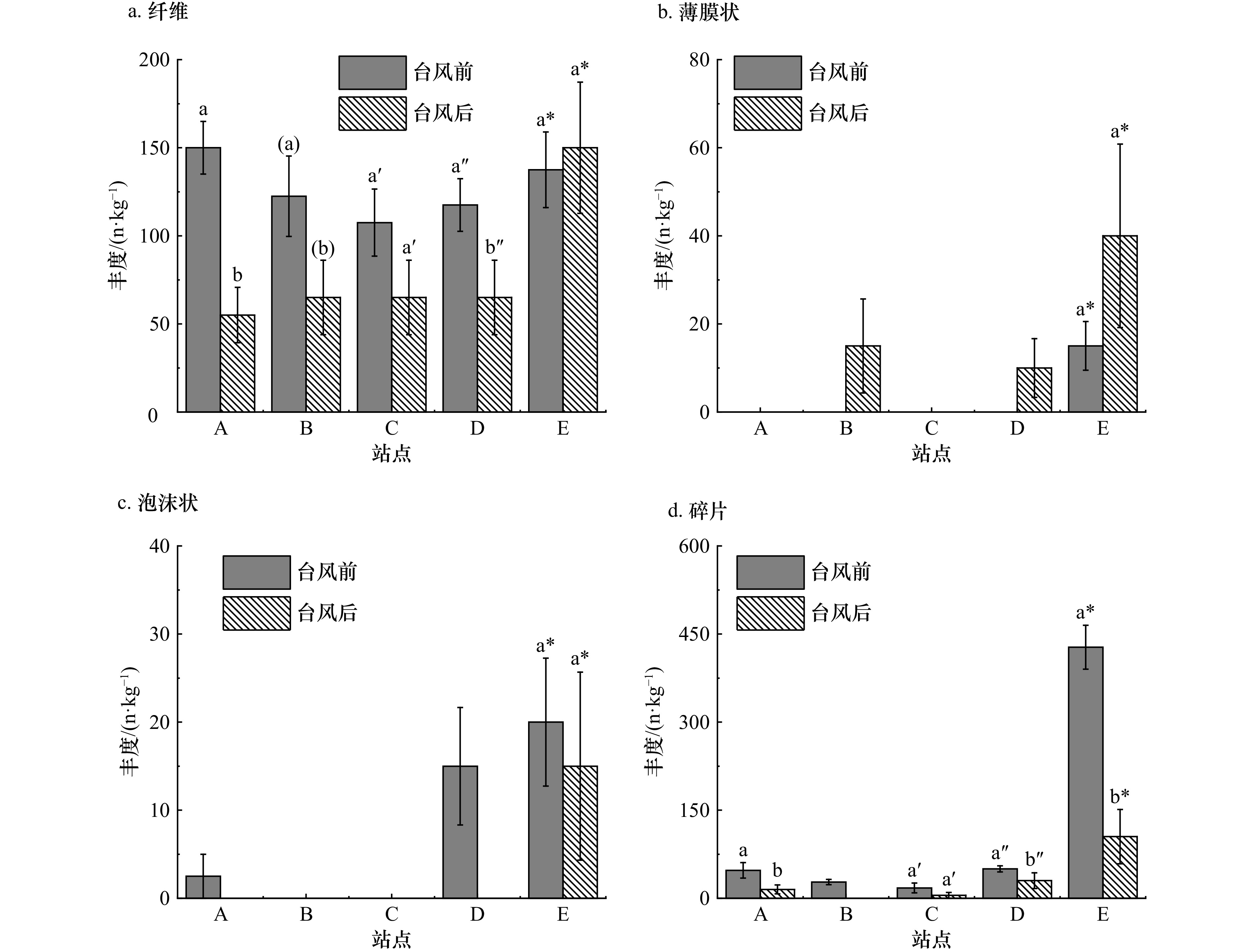
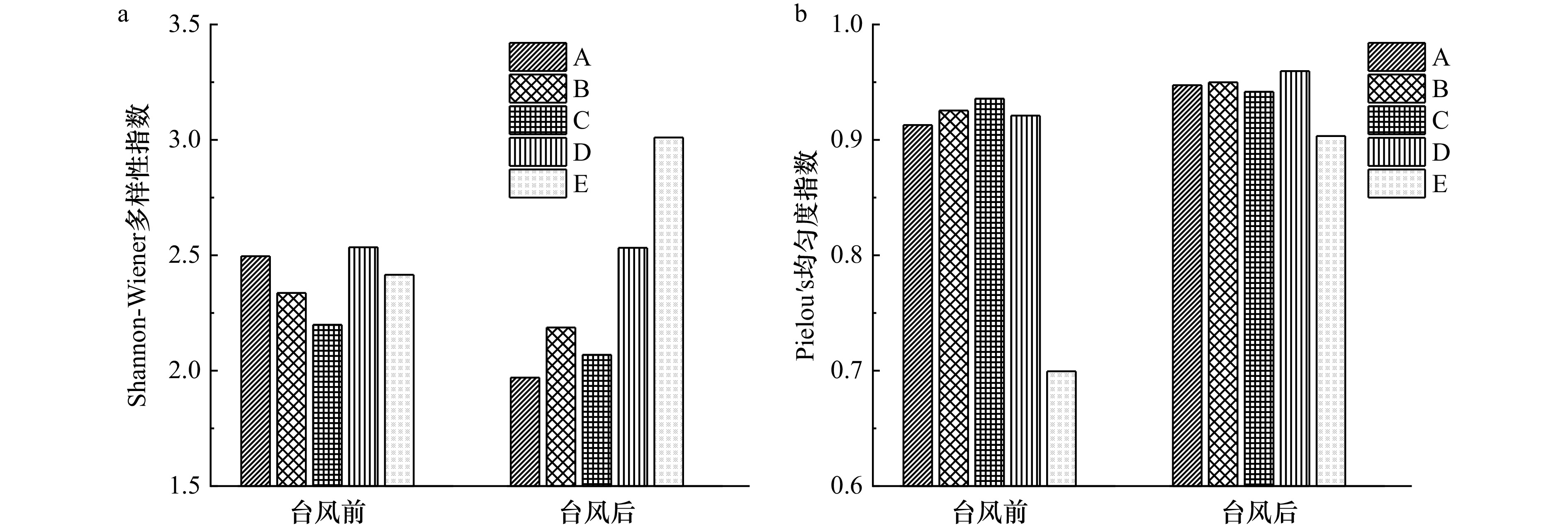
Studying the occurrence and dynamics of microplastics on coastal beaches is crucial for the integrated management of coastal zones and the assessment of ecological risks. Previous research has highlighted that physical processes play a pivotal role in influencing the occurrences of microplastic on coastal beaches. However, the impact of extreme meteorological events such as typhoons on the distribution of microplastic pollution has yet to be explored. This study conducted field fixed-plot experiments on the coastal beaches of Xiamen City before and after Typhoon "Haikui" to analyze the variations in the abundance, composition, and diversity of microplastic on beaches. The results showed that the abundance of microplastics on the beaches in Xiamen City before Typhoon Haikui was (251.5 ± 27.9) n/kg, and this value significantly decreased to (127.0 ± 18.8) n/kg post-typhoon. Before and after the typhoon, the composition of microplastics on the beaches showed distinct variations, with the abundance of microplastics of different shapes and sizes responding differently to the typhoon. In particular, the abundance of smaller particles (<500 μm) significantly decreased, while the proportion of fibrous particles increased. Moreover, the typhoon event led to a general decrease in the Shannon-Wiener diversity index, while an increase in the Pielou’s evenness index. The impact of typhoons on the distribution of microplastics on beaches arises from the complex coupling of multiple dynamic physical processes in extreme weather, and it is also closely related to factors such as the location and substrate conditions of the coasts. To achieve simulation and prediction of the dynamics of microplastic pollution during typhoon processes, systematic and comprehensive research on the relevant mechanisms is still required in the future.
Studying the occurrence and dynamics of microplastics on coastal beaches is crucial for the integrated management of coastal zones and the assessment of ecological risks. Previous research has highlighted that physical processes play a pivotal role in influencing the occurrences of microplastic on coastal beaches. However, the impact of extreme meteorological events such as typhoons on the distribution of microplastic pollution has yet to be explored. This study conducted field fixed-plot experiments on the coastal beaches of Xiamen City before and after Typhoon "Haikui" to analyze the variations in the abundance, composition, and diversity of microplastic on beaches. The results showed that the abundance of microplastics on the beaches in Xiamen City before Typhoon Haikui was (251.5 ± 27.9) n/kg, and this value significantly decreased to (127.0 ± 18.8) n/kg post-typhoon. Before and after the typhoon, the composition of microplastics on the beaches showed distinct variations, with the abundance of microplastics of different shapes and sizes responding differently to the typhoon. In particular, the abundance of smaller particles (<500 μm) significantly decreased, while the proportion of fibrous particles increased. Moreover, the typhoon event led to a general decrease in the Shannon-Wiener diversity index, while an increase in the Pielou’s evenness index. The impact of typhoons on the distribution of microplastics on beaches arises from the complex coupling of multiple dynamic physical processes in extreme weather, and it is also closely related to factors such as the location and substrate conditions of the coasts. To achieve simulation and prediction of the dynamics of microplastic pollution during typhoon processes, systematic and comprehensive research on the relevant mechanisms is still required in the future.


, Available online
Abstract:
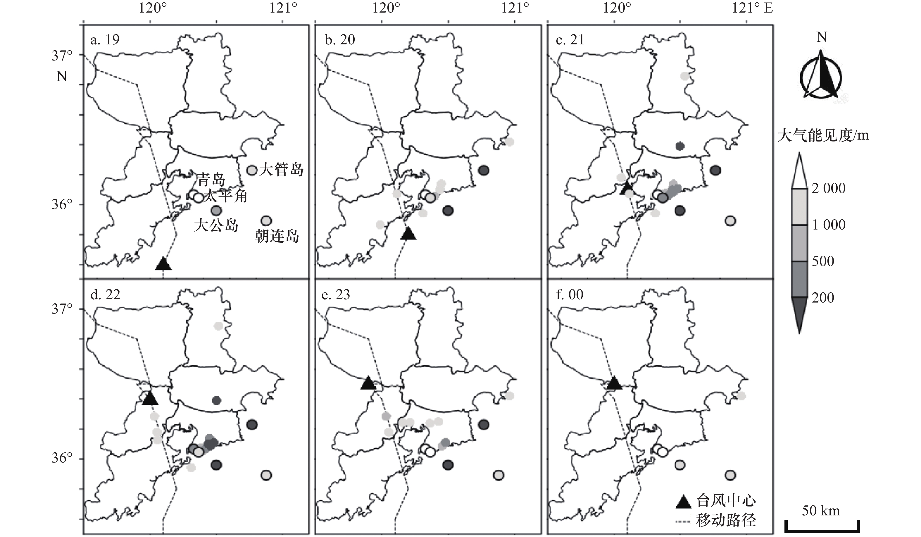
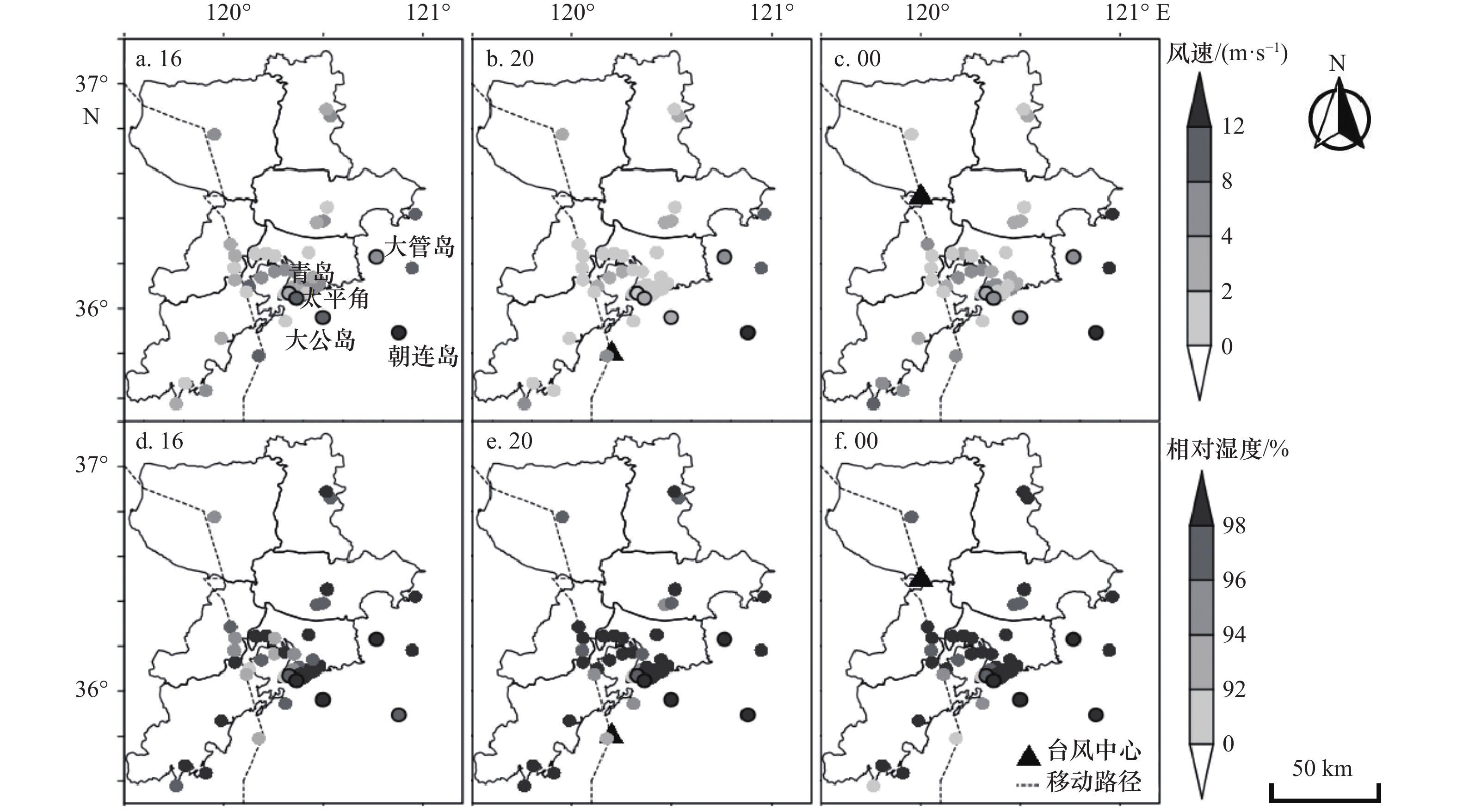
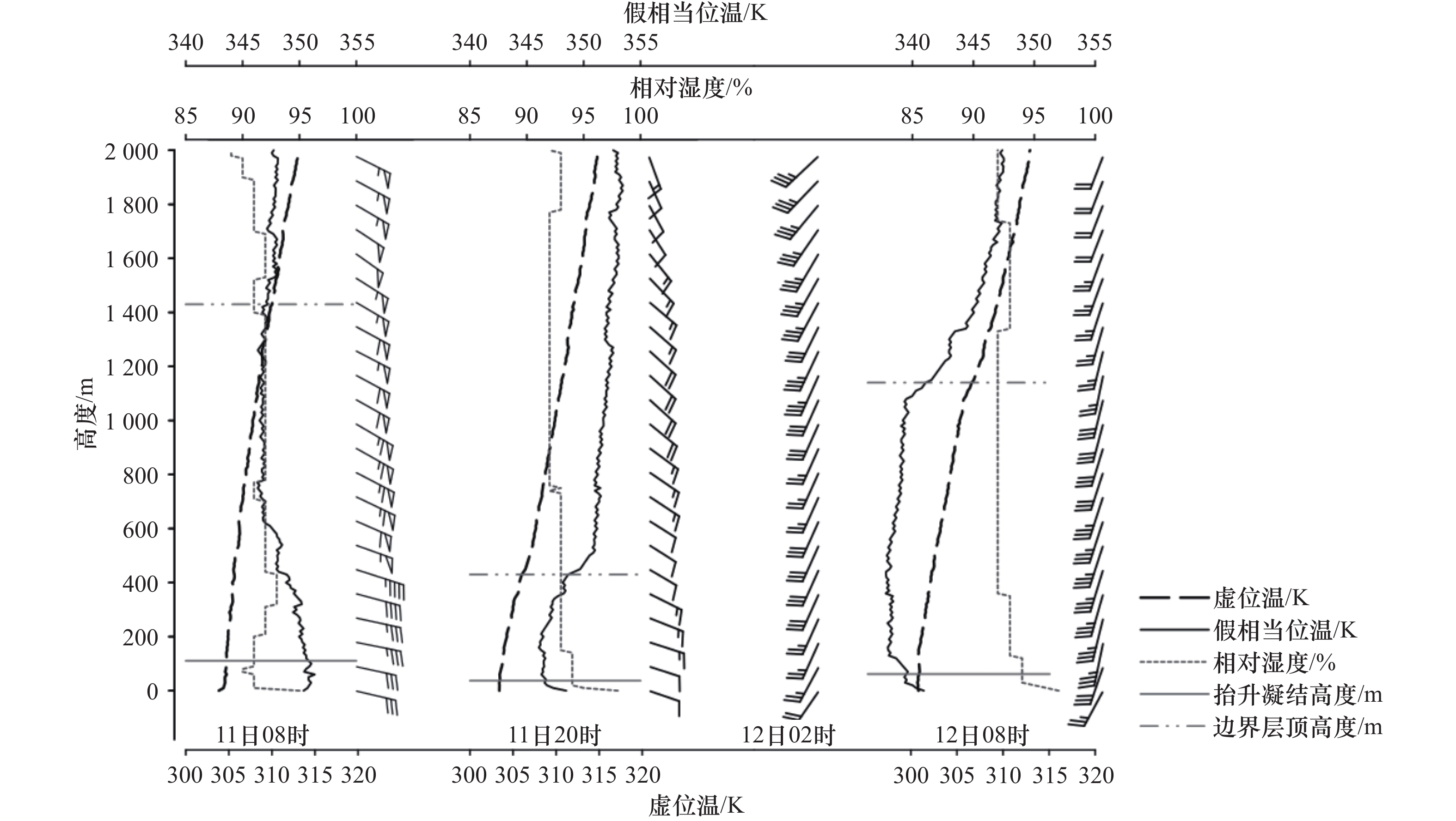
This study focuses on the physical process of a sea fog event during Typhoon Lekima in the Northern Yellow Sea by using observation data, reanalysis data and backward trajectory model. The analysis indicates that the typhoon circulation was the decisive factor determining whether fog formed offshore and developed inland. The warm and humid southerlies from the south Yellow Sea condensed into fog on the colder sea surface besides the typhoon center, which not only provided sufficient moisture for the formation and development of the sea fog but also formed a significant inversion layer over the fog area with the downdraft in the center of the typhoon. The "stable up and turbulent down" structure in the atmospheric boundary layer improved the development of sea fog on the coast and inland area. However, the horizontal wind steering and the strengthening wind speed behind the typhoon strengthened the wind shear in the atmospheric boundary layer, resulting in the enhanced turbulent mixing and the decrease of the stability in the bottom atmospheric boundary layer, which was the main cause of the fog dissipation.
This study focuses on the physical process of a sea fog event during Typhoon Lekima in the Northern Yellow Sea by using observation data, reanalysis data and backward trajectory model. The analysis indicates that the typhoon circulation was the decisive factor determining whether fog formed offshore and developed inland. The warm and humid southerlies from the south Yellow Sea condensed into fog on the colder sea surface besides the typhoon center, which not only provided sufficient moisture for the formation and development of the sea fog but also formed a significant inversion layer over the fog area with the downdraft in the center of the typhoon. The "stable up and turbulent down" structure in the atmospheric boundary layer improved the development of sea fog on the coast and inland area. However, the horizontal wind steering and the strengthening wind speed behind the typhoon strengthened the wind shear in the atmospheric boundary layer, resulting in the enhanced turbulent mixing and the decrease of the stability in the bottom atmospheric boundary layer, which was the main cause of the fog dissipation.


, Available online
Abstract:
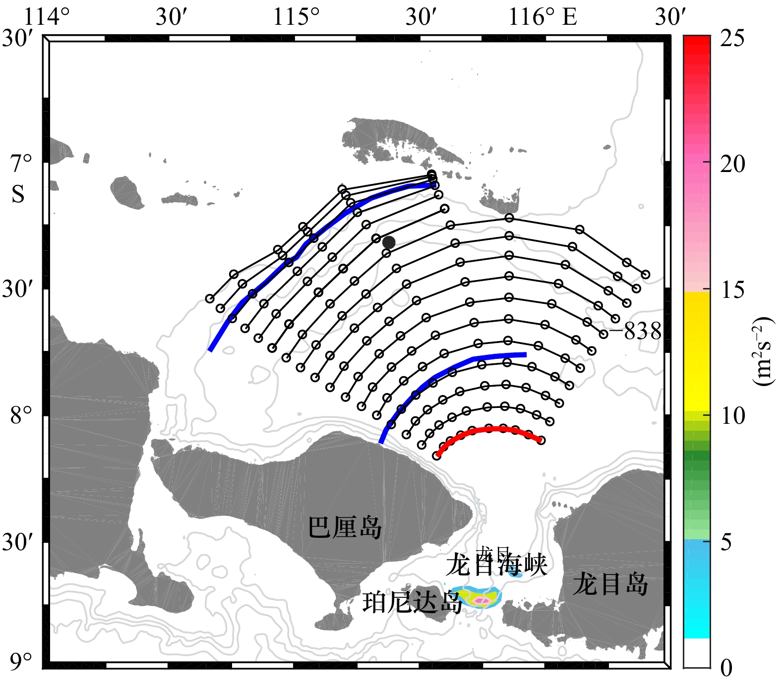
The possibility of the Indonesian submarine wreck on 20 April 2021 was analyzed based on satellite remote sensing observation and numerical simulation. The results indicate that large-amplitude oceanic internal waves, estimated to be approximately 50 m using satellite images, originate from the Lombok Strait. They are widely distributed to the north of the Bali Island and are suggested to cause an abrupt sinking of the Indonesian submarine.
The possibility of the Indonesian submarine wreck on 20 April 2021 was analyzed based on satellite remote sensing observation and numerical simulation. The results indicate that large-amplitude oceanic internal waves, estimated to be approximately 50 m using satellite images, originate from the Lombok Strait. They are widely distributed to the north of the Bali Island and are suggested to cause an abrupt sinking of the Indonesian submarine.

, Available online
Abstract:
Abstract:The potential fish production was controlled largely by ocean primary production (OPP) and there were a lot of research findings of estimating fish production by using OPP in China. The relationships between the biomass of fishery stock and OPP were often complicated by the varieties of trophic control in the ecosystem. In this paper, we examined the relationship between biomass of chub mackerel (Scomber japonicus) and net primary production (NPP) and discussed mechanism of trophic control in the ecosystem of chub mackerel fishing ground in south East China Sea by using catch and effort data from the large purse sense of China fishery and NPP derived from remote sensing. The results showed there was a significant non-linear relationship between NPP and standardized CPUE (Catch Per Unit Effort) (P<0.05) instead of the linear trend. The non-linear relationship could be described by a reversed parabolic curve, which meant the biomass of chub mackerel increased with NPP and then decreased when the NPP exceeded a point. The results implied there were other trophic controls in addition to bottom-up control occurred in the ecosystem in south East China Sea. We speculated the change of abundance of the key species at intermediate trophic levels or/and interspecific competitions contribute to the relationship.
Abstract:The potential fish production was controlled largely by ocean primary production (OPP) and there were a lot of research findings of estimating fish production by using OPP in China. The relationships between the biomass of fishery stock and OPP were often complicated by the varieties of trophic control in the ecosystem. In this paper, we examined the relationship between biomass of chub mackerel (Scomber japonicus) and net primary production (NPP) and discussed mechanism of trophic control in the ecosystem of chub mackerel fishing ground in south East China Sea by using catch and effort data from the large purse sense of China fishery and NPP derived from remote sensing. The results showed there was a significant non-linear relationship between NPP and standardized CPUE (Catch Per Unit Effort) (P<0.05) instead of the linear trend. The non-linear relationship could be described by a reversed parabolic curve, which meant the biomass of chub mackerel increased with NPP and then decreased when the NPP exceeded a point. The results implied there were other trophic controls in addition to bottom-up control occurred in the ecosystem in south East China Sea. We speculated the change of abundance of the key species at intermediate trophic levels or/and interspecific competitions contribute to the relationship.
Display Method:
2026, 48(4): 1-10.
doi: 10.12284/hyxb20260032
Abstract:
This study employs the MITgcm two-dimensional non-hydrostatic numerical model to simulate the generation, propagation, and dissipation processes of wind-generated near-inertial internal waves in the low-latitude ocean region (2°–20°N) under both the traditional approximation and the nontraditional approximation. The effects of the nontraditional approximation (retention of the horizontal component of the Coriolis parameter) on the propagation pathways, energy dissipation, and ocean interior mixing of near-inertial internal waves are systematically analyzed. The nontraditional approximation broadens the dispersion relation of internal waves, enabling near-inertial internal waves to generate sub-inertial components. Consequently, these waves can cross the inertial latitudes defined under the traditional approximation and continuously transport energy toward higher latitudes and the deep ocean. Poleward-propagating near-inertial internal waves, under the nontraditional approximation, propagate downward to the seafloor in the vicinity of the inertial latitude. After bottom reflection, wave energy accumulates within the near-bottom layer, significantly enhancing vertical shear in this region and triggering shear instability, which leads to near-inertial internal waves energy dissipation. The mean dissipation power per unit zonal width in the shear instability region is 0.25 W/m, and the associated enhanced turbulent mixing drives diapycnal volume transport in the deep ocean reaching 1.2 × 10⁻⁴ Sv. Based on the model results and a global estimate of near-inertial wave energy dissipation, this study roughly estimates that under the non-traditional approximation, wind-generated near-inertial internal waves induce deep-ocean turbulent mixing, which drives a global upwelling of approximately 1 Sv. These results indicate that the non-traditional approximation is essential for accurately quantifying near-inertial wave energy dissipation and its role in the global meridional overturning circulation.
This study employs the MITgcm two-dimensional non-hydrostatic numerical model to simulate the generation, propagation, and dissipation processes of wind-generated near-inertial internal waves in the low-latitude ocean region (2°–20°N) under both the traditional approximation and the nontraditional approximation. The effects of the nontraditional approximation (retention of the horizontal component of the Coriolis parameter) on the propagation pathways, energy dissipation, and ocean interior mixing of near-inertial internal waves are systematically analyzed. The nontraditional approximation broadens the dispersion relation of internal waves, enabling near-inertial internal waves to generate sub-inertial components. Consequently, these waves can cross the inertial latitudes defined under the traditional approximation and continuously transport energy toward higher latitudes and the deep ocean. Poleward-propagating near-inertial internal waves, under the nontraditional approximation, propagate downward to the seafloor in the vicinity of the inertial latitude. After bottom reflection, wave energy accumulates within the near-bottom layer, significantly enhancing vertical shear in this region and triggering shear instability, which leads to near-inertial internal waves energy dissipation. The mean dissipation power per unit zonal width in the shear instability region is 0.25 W/m, and the associated enhanced turbulent mixing drives diapycnal volume transport in the deep ocean reaching 1.2 × 10⁻⁴ Sv. Based on the model results and a global estimate of near-inertial wave energy dissipation, this study roughly estimates that under the non-traditional approximation, wind-generated near-inertial internal waves induce deep-ocean turbulent mixing, which drives a global upwelling of approximately 1 Sv. These results indicate that the non-traditional approximation is essential for accurately quantifying near-inertial wave energy dissipation and its role in the global meridional overturning circulation.


2026, 48(4): 11-18.
doi: 10.12284/hyxb20260038
Abstract:
Oceanic ridges can channel tsunami energy as trapped waves that propagate over distances exceeding ten thousand kilometers. Owing to their distinct propagation characteristics, these waves carry substantial energy to remote oceanic regions, posing serious threats to coastal engineering structures and to human life and property. Using potential flow theory, this study derives an analytical solution for trapped waves over a stepped ridge. It is mathematically demonstrated that trapped waves over a step-type ridge arise from wave reflection at the abrupt topographic change, and an explicit expression is provided for the critical condition required for total internal reflection to occur—thereby enabling wave trapping. The results show that lower-frequency wave components are more readily trapped by the stepped topography, and that the trapping effect becomes increasingly pronounced as the incident wave angle increases. By adopting the full-depth potential flow theory, this study overcomes the limitation of previous theories that are applicable only to shallow-water waves, thus offering reliable theoretical formulations for investigating trapped waves over realistic, steep ridge topographies.
Oceanic ridges can channel tsunami energy as trapped waves that propagate over distances exceeding ten thousand kilometers. Owing to their distinct propagation characteristics, these waves carry substantial energy to remote oceanic regions, posing serious threats to coastal engineering structures and to human life and property. Using potential flow theory, this study derives an analytical solution for trapped waves over a stepped ridge. It is mathematically demonstrated that trapped waves over a step-type ridge arise from wave reflection at the abrupt topographic change, and an explicit expression is provided for the critical condition required for total internal reflection to occur—thereby enabling wave trapping. The results show that lower-frequency wave components are more readily trapped by the stepped topography, and that the trapping effect becomes increasingly pronounced as the incident wave angle increases. By adopting the full-depth potential flow theory, this study overcomes the limitation of previous theories that are applicable only to shallow-water waves, thus offering reliable theoretical formulations for investigating trapped waves over realistic, steep ridge topographies.


2026, 48(4): 19-34.
doi: 10.12284/hyxb20260022
Abstract:
To accurately simulate nearshore wave-induced currents, this study proposes a general construction method for vertical weighting functions. Based on this method, existing depth-dependent horizontal wave radiation stress formulations are unified, and a modified formulation (Z04m) with tunable vertical distribution characteristics is derived. This formulation features a smooth and continuous vertical profile and allows for flexible adaptation to varying wave conditions and sloping topographies by adjusting a single parameter. Using a developed two-way coupled three-dimensional coastal wave-current interaction model, the applicability of different formulations is comprehensively evaluated. The model is validated against four laboratory flume experiments with varying conditions. The results show that the performance of different radiation stress formulations varies considerably in reproducing wave-induced current structures. The modified formulation outperforms the existing ones in simulating wave setup/setdown, significant wave height, and cross-shore vertical velocity profiles, with a significantly reduced root mean square error in cross-shore velocities compared with other formulations. Regarding the potential vertical momentum imbalance associated with using depth-dependent horizontal radiation stress formulations over sloping bottoms, momentum balance diagnostics based on the Roseau-type topography confirm the feasibility of the modified formulation, which includes only horizontal components. Its momentum balance characteristics are comparable to those of higher-order formulations that incorporate vertical components. The vertical momentum balance characteristics of other depth-dependent horizontal radiation stress formulations are also presented, and some are found to be imbalanced.
To accurately simulate nearshore wave-induced currents, this study proposes a general construction method for vertical weighting functions. Based on this method, existing depth-dependent horizontal wave radiation stress formulations are unified, and a modified formulation (Z04m) with tunable vertical distribution characteristics is derived. This formulation features a smooth and continuous vertical profile and allows for flexible adaptation to varying wave conditions and sloping topographies by adjusting a single parameter. Using a developed two-way coupled three-dimensional coastal wave-current interaction model, the applicability of different formulations is comprehensively evaluated. The model is validated against four laboratory flume experiments with varying conditions. The results show that the performance of different radiation stress formulations varies considerably in reproducing wave-induced current structures. The modified formulation outperforms the existing ones in simulating wave setup/setdown, significant wave height, and cross-shore vertical velocity profiles, with a significantly reduced root mean square error in cross-shore velocities compared with other formulations. Regarding the potential vertical momentum imbalance associated with using depth-dependent horizontal radiation stress formulations over sloping bottoms, momentum balance diagnostics based on the Roseau-type topography confirm the feasibility of the modified formulation, which includes only horizontal components. Its momentum balance characteristics are comparable to those of higher-order formulations that incorporate vertical components. The vertical momentum balance characteristics of other depth-dependent horizontal radiation stress formulations are also presented, and some are found to be imbalanced.


2026, 48(4): 35-46.
doi: 10.12284/hyxb20260028
Abstract:
Observational limitations constrain long-term studies of Arctic linear kinematic features (LKFs). This study systematically analyzes the long-term changes of Arctic LKFs and their climate drivers using a 28-year, ~2 km resolution pan-Arctic sea ice-ocean simulation, validated against winter RGPS data (1996–2008). We find no pronounced trend in pan-Arctic LKF number or density, though a very weak increase (0.003 a−1) aligns with thinning-enhanced fracturing. Modeled winter LKF density correlates well with RGPS observations (r = 0.57), confirming the model’s reliability in capturing the spatial distribution and seasonal variations of LKFs. Summer LKF density shows a strong negative correlation with the Arctic Dipole (AD) (r = −0.66), exceeding the Arctic Oscillation (AO) influence. While both AO and AD correlate negatively with LKF density in the central Arctic, LKF density correlates positively with AO but negatively with AD in the Kara Sea and Barents Sea, resulting in an overall stronger negative correlation with AD.
Observational limitations constrain long-term studies of Arctic linear kinematic features (LKFs). This study systematically analyzes the long-term changes of Arctic LKFs and their climate drivers using a 28-year, ~2 km resolution pan-Arctic sea ice-ocean simulation, validated against winter RGPS data (1996–2008). We find no pronounced trend in pan-Arctic LKF number or density, though a very weak increase (0.003 a−1) aligns with thinning-enhanced fracturing. Modeled winter LKF density correlates well with RGPS observations (r = 0.57), confirming the model’s reliability in capturing the spatial distribution and seasonal variations of LKFs. Summer LKF density shows a strong negative correlation with the Arctic Dipole (AD) (r = −0.66), exceeding the Arctic Oscillation (AO) influence. While both AO and AD correlate negatively with LKF density in the central Arctic, LKF density correlates positively with AO but negatively with AD in the Kara Sea and Barents Sea, resulting in an overall stronger negative correlation with AD.


2026, 48(4): 47-55.
doi: 10.12284/hyxb20260030
Abstract:
This paper briefly introduces the in-situ geoacoustic measurement system (SAS), which is based on high-frequency micro-vibration penetration technology. The system is composed of mechanical-hydraulic units, acoustic transducers, an acoustic emission and acquisition unit, an overall control unit, and auxiliary measurement units. It is designed for measuring the mid-frequency sound speed and attenuation coefficient of seafloor sediments. In April 2025, the system was deployed aboard the R/V “Xiangyanghong 01” to conduct in-situ acoustic measurements at nine stations in the northern continental shelf of South China Sea. At eight of these stations, the maximum penetration depth exceeded 3 meters, covering a frequency range of 1.6−10.0 kHz. The calculated sound speed shows distinct differences among the nine stations: the sound speed ratio at the first group of three stations varies between 1.01 and 1.03; at the second group of four stations, the ratio is significantly less than 1.0, ranging between 0.97 and 0.98; and at the third group of two stations, the ratio lies between the previous two groups, around 1.0. Comparison with synchronously obtained sediment core samples reveals a high correlation between sound velocity characteristics and the physical property parameters of sediments. When the sand content is high and the water content is low, the sound velocity in sediments exceeds that of near-bottom seawater; when the sand content is low and the water content is high, the sound velocity in sediments is lower than that of near-bottom seawater. Sand content and water content may be the primary factors determining whether sediment sound velocity is greater or less than that of near-bottom seawater. At the nine stations, sound speed dispersion is approximately 2% in coarser sandy sediments (\begin{document}$ \mathit{\Phi }= $\end{document} \begin{document}$ \mathit{\Phi }= $\end{document}
This paper briefly introduces the in-situ geoacoustic measurement system (SAS), which is based on high-frequency micro-vibration penetration technology. The system is composed of mechanical-hydraulic units, acoustic transducers, an acoustic emission and acquisition unit, an overall control unit, and auxiliary measurement units. It is designed for measuring the mid-frequency sound speed and attenuation coefficient of seafloor sediments. In April 2025, the system was deployed aboard the R/V “Xiangyanghong 01” to conduct in-situ acoustic measurements at nine stations in the northern continental shelf of South China Sea. At eight of these stations, the maximum penetration depth exceeded 3 meters, covering a frequency range of 1.6−10.0 kHz. The calculated sound speed shows distinct differences among the nine stations: the sound speed ratio at the first group of three stations varies between 1.01 and 1.03; at the second group of four stations, the ratio is significantly less than 1.0, ranging between 0.97 and 0.98; and at the third group of two stations, the ratio lies between the previous two groups, around 1.0. Comparison with synchronously obtained sediment core samples reveals a high correlation between sound velocity characteristics and the physical property parameters of sediments. When the sand content is high and the water content is low, the sound velocity in sediments exceeds that of near-bottom seawater; when the sand content is low and the water content is high, the sound velocity in sediments is lower than that of near-bottom seawater. Sand content and water content may be the primary factors determining whether sediment sound velocity is greater or less than that of near-bottom seawater. At the nine stations, sound speed dispersion is approximately 2% in coarser sandy sediments (


2026, 48(4): 56-68.
doi: 10.12284/hyxb20260024
Abstract:
The depth of closure is a key parameter in studies of sediment budget balance and coastal morphodynamics, and plays an important role in coastal erosion-related engineering applications. Traditional methods for estimating the depth of closure are mostly developed for wave-dominated coasts and generally neglect the influence of tidal currents, which limits their applicability to mesotidal embayments. Taking Haizhou Bay in the Lianyungang coastal area as a case study, this study systematically investigates the influence of tidal currents on the depth of closure by integrating field observations, numerical simulations, and theoretical analysis. The numerical results indicate that tidal currents in Haizhou Bay exhibit a decreasing trend from north to south, and that tidal forcing significantly enhances nearshore sediment mobilization. Under combined wave-current conditions, the depth of closure is estimated to range from 8.0 to 10.1 m, representing an increase of 0.4−1.3 m compared with the wave-only condition. Comparisons with historical bathymetric charts suggest that the observed depth of closure in Haizhou Bay generally falls within the range of 8.9−9.8 m, which is in good agreement with the results obtained in this study, further demonstrating the reliability of the proposed approach. The new method highlights the role of tidal currents in increasing bed shear stress in mesotidal embayments and explicitly accounts for their influence on the depth of closure, providing a sound scientific basis and technical support for coastal engineering applications in similar environments.
The depth of closure is a key parameter in studies of sediment budget balance and coastal morphodynamics, and plays an important role in coastal erosion-related engineering applications. Traditional methods for estimating the depth of closure are mostly developed for wave-dominated coasts and generally neglect the influence of tidal currents, which limits their applicability to mesotidal embayments. Taking Haizhou Bay in the Lianyungang coastal area as a case study, this study systematically investigates the influence of tidal currents on the depth of closure by integrating field observations, numerical simulations, and theoretical analysis. The numerical results indicate that tidal currents in Haizhou Bay exhibit a decreasing trend from north to south, and that tidal forcing significantly enhances nearshore sediment mobilization. Under combined wave-current conditions, the depth of closure is estimated to range from 8.0 to 10.1 m, representing an increase of 0.4−1.3 m compared with the wave-only condition. Comparisons with historical bathymetric charts suggest that the observed depth of closure in Haizhou Bay generally falls within the range of 8.9−9.8 m, which is in good agreement with the results obtained in this study, further demonstrating the reliability of the proposed approach. The new method highlights the role of tidal currents in increasing bed shear stress in mesotidal embayments and explicitly accounts for their influence on the depth of closure, providing a sound scientific basis and technical support for coastal engineering applications in similar environments.


2026, 48(4): 69-80.
doi: 10.12284/hyxb20260026
Abstract:
The hydrodynamic performance of a floating oscillating water column (OWC) breakwater under the co-action of waves and currents is numerically investigated. A time domain two-dimensional (2D) fully nonlinear numerical model was established for the OWC-breakwater, and its reliability was validated using experimental data. The effects of the current speed, the rear wall draft, and the rear wall thickness on the transmission coefficient, the reflection coefficient, and the hydrodynamic efficiency are numerically analyzed. The results indicate that under following current conditions, the transmission coefficient, reflection coefficient, and hydrodynamic efficiency of the device all exhibit a decreasing trend; whereas under opposing current conditions, the opposite trends are observed. Furthermore, increasing the rear wall draft reduces the transmission coefficient and improves the hydrodynamic efficiency, with a limited effect on the reflection coefficient. Besides, increasing the rear wall thickness also decreases the transmission coefficient and enhances hydrodynamic efficiency, while its influence on the reflection coefficient is insignificant. The findings of this study provide important references for the structural optimization and engineering design of OWC breakwaters.
The hydrodynamic performance of a floating oscillating water column (OWC) breakwater under the co-action of waves and currents is numerically investigated. A time domain two-dimensional (2D) fully nonlinear numerical model was established for the OWC-breakwater, and its reliability was validated using experimental data. The effects of the current speed, the rear wall draft, and the rear wall thickness on the transmission coefficient, the reflection coefficient, and the hydrodynamic efficiency are numerically analyzed. The results indicate that under following current conditions, the transmission coefficient, reflection coefficient, and hydrodynamic efficiency of the device all exhibit a decreasing trend; whereas under opposing current conditions, the opposite trends are observed. Furthermore, increasing the rear wall draft reduces the transmission coefficient and improves the hydrodynamic efficiency, with a limited effect on the reflection coefficient. Besides, increasing the rear wall thickness also decreases the transmission coefficient and enhances hydrodynamic efficiency, while its influence on the reflection coefficient is insignificant. The findings of this study provide important references for the structural optimization and engineering design of OWC breakwaters.


2026, 48(4): 81-93.
doi: 10.12284/hyxb20260034
Abstract:
This study conducted multi-objective intelligent prediction research on the excess pore water pressure around double-pile foundations in the seabed under wave action. Firstly, the time-history evolution and spatial distribution of excess pore water pressure around the double-pile foundation under different wave heights are analyzed by wave flume test. Secondly, the phase lag detection and dynamic alignment method are used to preprocess the data, and GRU and ELM neural networks are used for training prediction respectively. Finally, the dynamic error preferred fusion method is used to fuse the outputs of the two models. The results show that under the current test conditions, with the increase of wave height, the amplitude of excess pore water pressure in the seabed around the double-pile foundation increases significantly, showing obvious amplitude attenuation and phase lag along the depth direction, and there are obvious spatial differences in the maximum amplitude of excess pore water pressure around the double-pile foundation. In addition, the constructed fusion model performs best compared with the original model or single model evaluation metrics, where PCC is0.9827 , NSE is 0.9218 , RMSE is 0.003305 , and MAE is 0.002559 . The research results provide an effective way for the intelligent prediction of multi-objective pore pressure of seabed around pile foundation under wave action.
This study conducted multi-objective intelligent prediction research on the excess pore water pressure around double-pile foundations in the seabed under wave action. Firstly, the time-history evolution and spatial distribution of excess pore water pressure around the double-pile foundation under different wave heights are analyzed by wave flume test. Secondly, the phase lag detection and dynamic alignment method are used to preprocess the data, and GRU and ELM neural networks are used for training prediction respectively. Finally, the dynamic error preferred fusion method is used to fuse the outputs of the two models. The results show that under the current test conditions, with the increase of wave height, the amplitude of excess pore water pressure in the seabed around the double-pile foundation increases significantly, showing obvious amplitude attenuation and phase lag along the depth direction, and there are obvious spatial differences in the maximum amplitude of excess pore water pressure around the double-pile foundation. In addition, the constructed fusion model performs best compared with the original model or single model evaluation metrics, where PCC is


2026, 48(4): 94-109.
doi: 10.12284/hyxb20260010
Abstract:
High-quality underwater optical images are crucial for tasks such as digital twins of seabed scenes, benthic habitat protection, seabed mineral resource detection, and understanding unknown underwater phenomena. However, due to factors such as complex aquatic environments and lighting conditions, underwater optical images suffer from degradation issues including color distortion, blurred details, and low contrast. Existing underwater image enhancement methods often focus on optimizing enhancement algorithms themselves, lacking systematic analytical mechanisms for tracing, classifying, and grading different types of degradation. To address this, considering the complexity and heterogeneity of underwater optical imaging environments, this paper proposes an image quality enhancement strategy that takes degradation types into account. First, a degradation-type-aware network is constructed to identify underwater hazy and blurred images, achieving an accuracy of 97%, and also demonstrating a high distinguishing capability for illumination degradation types. Second, for the identified underwater hazy images, an adaptive color correction method is designed based on the statistical distribution of color bias values in real underwater images, effectively restoring color attenuation in varying degrees. Finally, a block indexing strategy is introduced to obtain more precise background light estimates, further addressing the hazy blur issue in underwater images in conjunction with the underwater dark channel prior. Experimental results on various real underwater image datasets, including UIEB and RUIE, indicate that compared to representative underwater image enhancement methods, the PSNR and SSIM metrics are improved by 22.17% and 4.5%, respectively.
High-quality underwater optical images are crucial for tasks such as digital twins of seabed scenes, benthic habitat protection, seabed mineral resource detection, and understanding unknown underwater phenomena. However, due to factors such as complex aquatic environments and lighting conditions, underwater optical images suffer from degradation issues including color distortion, blurred details, and low contrast. Existing underwater image enhancement methods often focus on optimizing enhancement algorithms themselves, lacking systematic analytical mechanisms for tracing, classifying, and grading different types of degradation. To address this, considering the complexity and heterogeneity of underwater optical imaging environments, this paper proposes an image quality enhancement strategy that takes degradation types into account. First, a degradation-type-aware network is constructed to identify underwater hazy and blurred images, achieving an accuracy of 97%, and also demonstrating a high distinguishing capability for illumination degradation types. Second, for the identified underwater hazy images, an adaptive color correction method is designed based on the statistical distribution of color bias values in real underwater images, effectively restoring color attenuation in varying degrees. Finally, a block indexing strategy is introduced to obtain more precise background light estimates, further addressing the hazy blur issue in underwater images in conjunction with the underwater dark channel prior. Experimental results on various real underwater image datasets, including UIEB and RUIE, indicate that compared to representative underwater image enhancement methods, the PSNR and SSIM metrics are improved by 22.17% and 4.5%, respectively.


2026, 48(4): 110-126.
doi: 10.12284/hyxb20260036
Abstract:
Based on observational data from four representative stations along the transect B in the Bering Sea during July 2012 (a cold year) and 2014 (a warm year), along with multiple sets of reanalysis data and climate model results, this study systematically evaluates the ability of different data sources to reproduce sea temperature structures from approximately 0 to1000 meters and their performance over multiple time scales using correlation coefficient, centered root mean square error (CRMSE), and standard deviation as evaluation metrics. The results show that the temperature variability in the upper ocean (0–200 m) is significantly higher than in the deeper layers (below 200 m). Reanalysis data generally have smaller average errors across all layers compared to climate model data. Specifically, for 2012, the error in the upper layers is about 0.3–0.5℃, while the model error is approximately 2℃; in the deep layers, the errors are about 0.1℃ and 1℃, respectively. In 2014, the errors in most models were lower than those in 2012, indicating that model performance is somewhat dependent on the climatic background. Long-term sequence analysis indicates that all data sources can reproduce the characteristic “cold winters and warm summers” seasonal cycle, but models show a systematic bias of about 1℃ in the middle layer temperature. On the interdecadal scale, the sea surface temperature anomaly (SSTA) shows consistent trends across data, while the middle layer temperature anomaly (MATA) exhibits time shifts of several years for extreme values. This study quantifies the error magnitude and uncertainty characteristics of different data in reproducing the upper ocean temperature structure in the Bering Sea, providing a quantitative reference for regional sea temperature variation analysis and multi-source data application.
Based on observational data from four representative stations along the transect B in the Bering Sea during July 2012 (a cold year) and 2014 (a warm year), along with multiple sets of reanalysis data and climate model results, this study systematically evaluates the ability of different data sources to reproduce sea temperature structures from approximately 0 to


Most DownloadedMORE>
- Increased influences of the SST along the Kuroshio in previous winter on the summer precipitation in northeastern China
- The satellite remotely-sensed analysis of the temporal and spatial variability of chlorophyll a concentration in the northern South China Sea
- Observation of the seasonal evolution of DO, chlorophyll a maximum phenomena and nutrient accumulating in the southern Huanghai (Yellow) Sea Cold Water Mass area
- Quantitative research on earthquake-generated tsunami hazards based on the numerical simulations in Bohai Sea


 Email alert
 RSS
RSS