


2023 Vol. 45, No. 9
Display Method:
2023, 45(9): 1-9.
doi: 10.12284/hyxb2023130
Abstract:
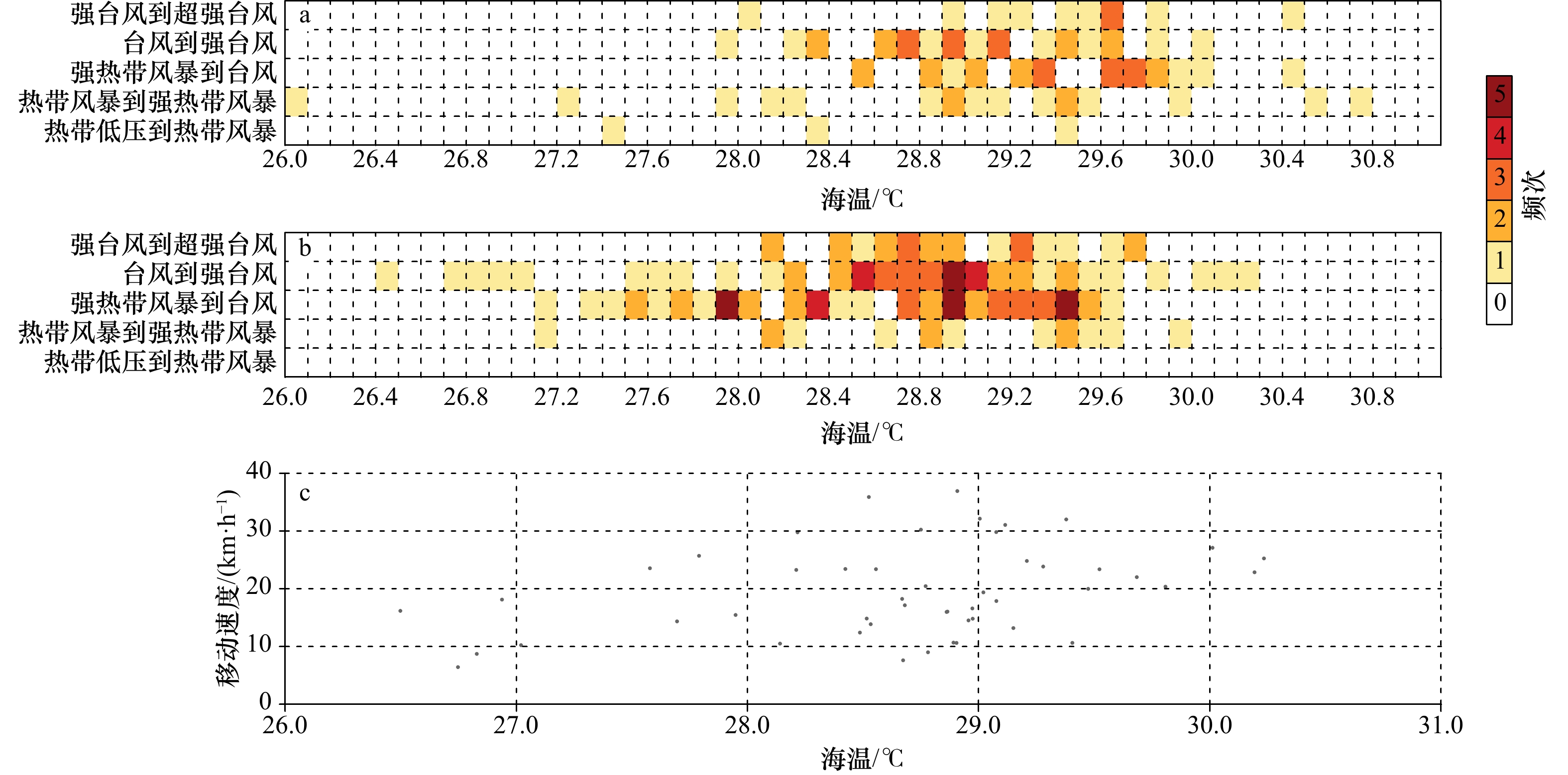
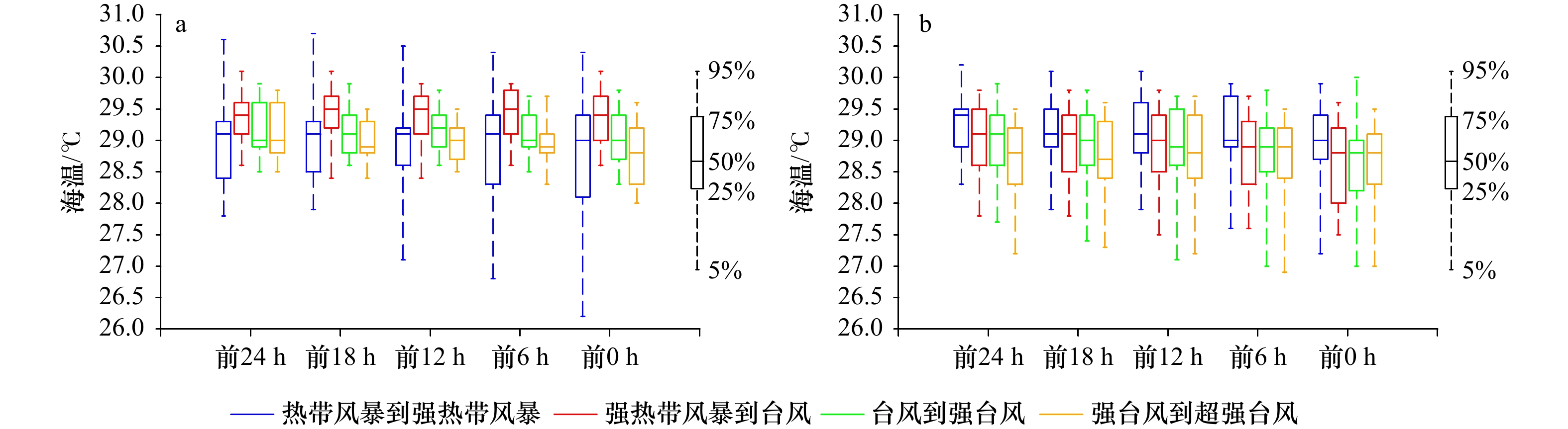
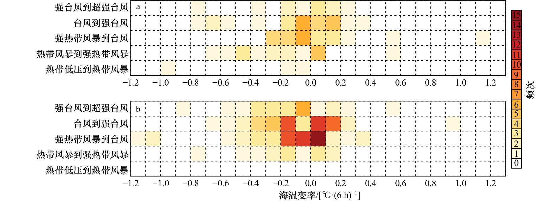
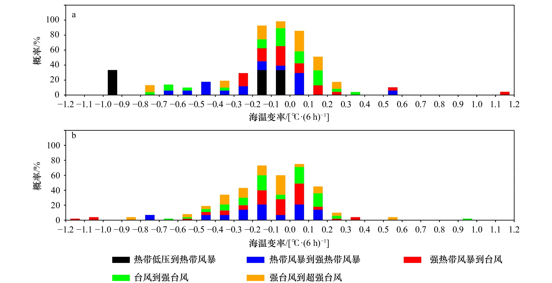
To better understand the influence of sea surface temperature (SST) on tropical cyclones rapidly intensifying, the characteristics of rapid changes in sea surface temperature and intensity of tropical cyclones in the western North Pacific during 1979−2019 were statistically analyzed using the tropical cyclones best track data compiled by the Shanghai Typhoon Research Institute of the China Meteorological Administration and the sea surface temperature data provided by European Centre for Medium-Range Weather Forecasts. The results indicate the following: (1) About 90% of the rapid intensification of tropical cyclones occurred in summer and autumn, accounting for 32.8% and 56.4% of the total number of rapid intensification respectively. Most tropical cyclones are dominated by rapid intensification across one intensity level, rapid intensification from a severe tropical storm to a typhoon and rapid intensification from a typhoon to a severe typhoon are the two conditions that occur more frequently. (2) The SST conditions greater than 28℃ in summer and 27.5℃ in autumn are conducive to the rapid intensification of tropical cyclones. Lower intensity of tropical cyclones require higher SST (> 29℃) for rapid intensification. The faster translation speed of tropical cyclones is conducive to maintaining high SST environment at its center. (3) When the time variation of SST is within ±0.2℃/(6 h), the horizontal spatial gradient is less than 0.4℃/(°), which is the favorable condition for the rapid intensification of tropical cyclone; the stronger the tropical cyclone is, the more stable the SST environment is needed. (4) When tropical cyclone is a severe tropical storm or above, it is better to judge whether rapid intensification occurs by using only the SST conditions. This work quantifies the SST environment conducive to tropical cyclone intensification and provides a technical reference for quantitative prediction of tropical cyclone intensity evolution based on SST.
To better understand the influence of sea surface temperature (SST) on tropical cyclones rapidly intensifying, the characteristics of rapid changes in sea surface temperature and intensity of tropical cyclones in the western North Pacific during 1979−2019 were statistically analyzed using the tropical cyclones best track data compiled by the Shanghai Typhoon Research Institute of the China Meteorological Administration and the sea surface temperature data provided by European Centre for Medium-Range Weather Forecasts. The results indicate the following: (1) About 90% of the rapid intensification of tropical cyclones occurred in summer and autumn, accounting for 32.8% and 56.4% of the total number of rapid intensification respectively. Most tropical cyclones are dominated by rapid intensification across one intensity level, rapid intensification from a severe tropical storm to a typhoon and rapid intensification from a typhoon to a severe typhoon are the two conditions that occur more frequently. (2) The SST conditions greater than 28℃ in summer and 27.5℃ in autumn are conducive to the rapid intensification of tropical cyclones. Lower intensity of tropical cyclones require higher SST (> 29℃) for rapid intensification. The faster translation speed of tropical cyclones is conducive to maintaining high SST environment at its center. (3) When the time variation of SST is within ±0.2℃/(6 h), the horizontal spatial gradient is less than 0.4℃/(°), which is the favorable condition for the rapid intensification of tropical cyclone; the stronger the tropical cyclone is, the more stable the SST environment is needed. (4) When tropical cyclone is a severe tropical storm or above, it is better to judge whether rapid intensification occurs by using only the SST conditions. This work quantifies the SST environment conducive to tropical cyclone intensification and provides a technical reference for quantitative prediction of tropical cyclone intensity evolution based on SST.

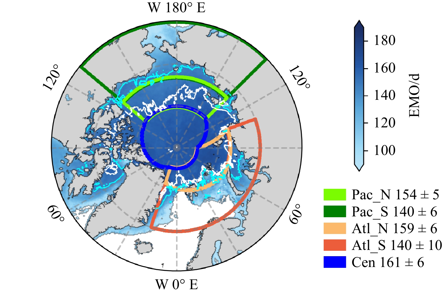
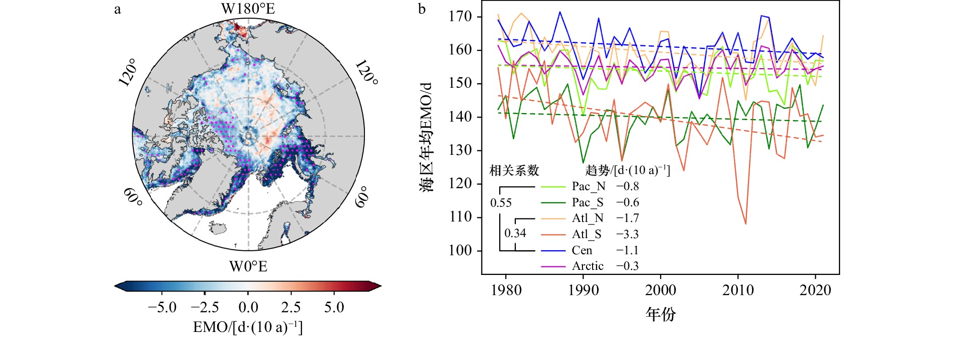
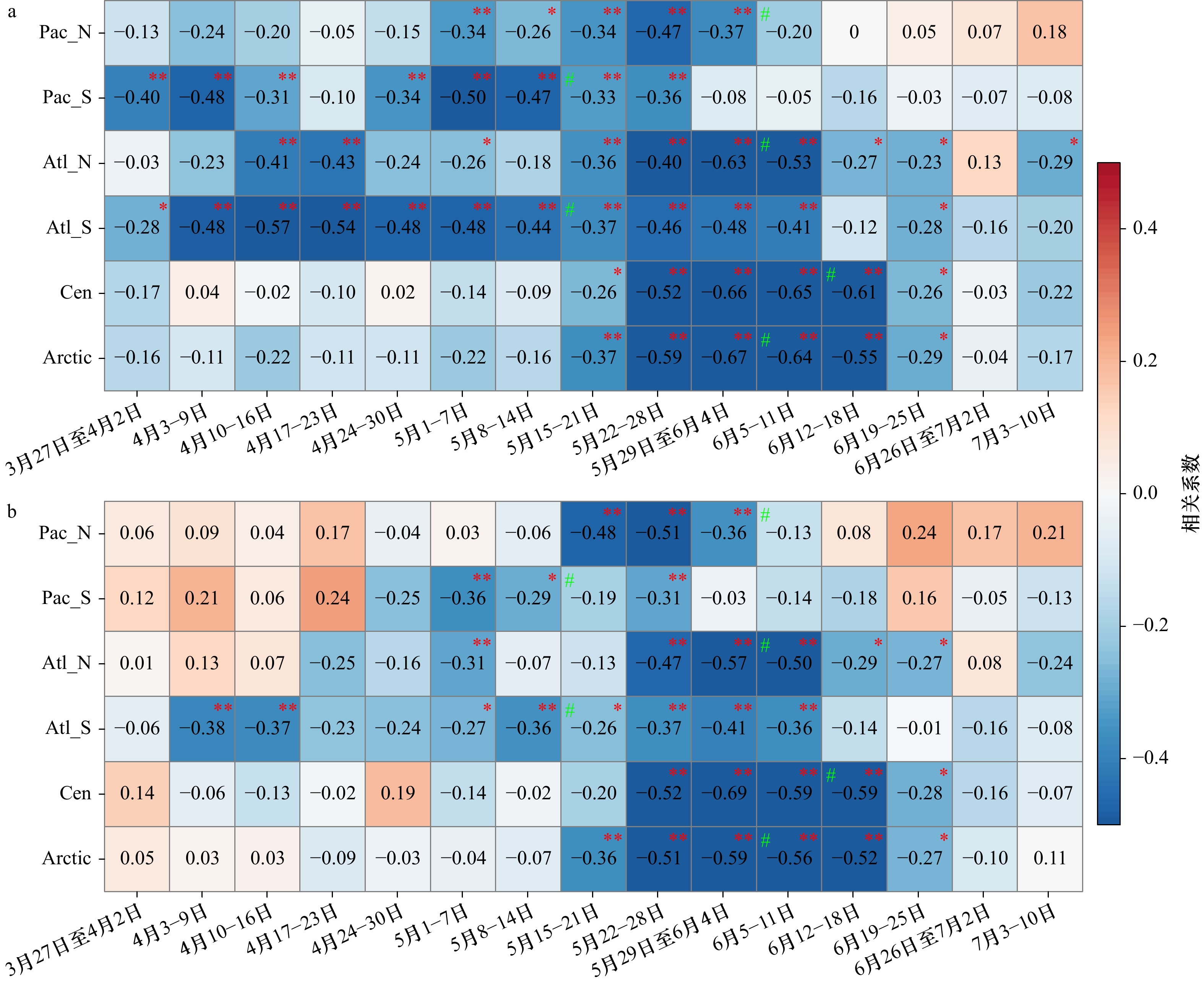
Effect of liquid precipitation and surface air temperature on the early melt onset of Arctic sea ice
2023, 45(9): 10-24.
doi: 10.12284/hyxb2023119
Abstract:
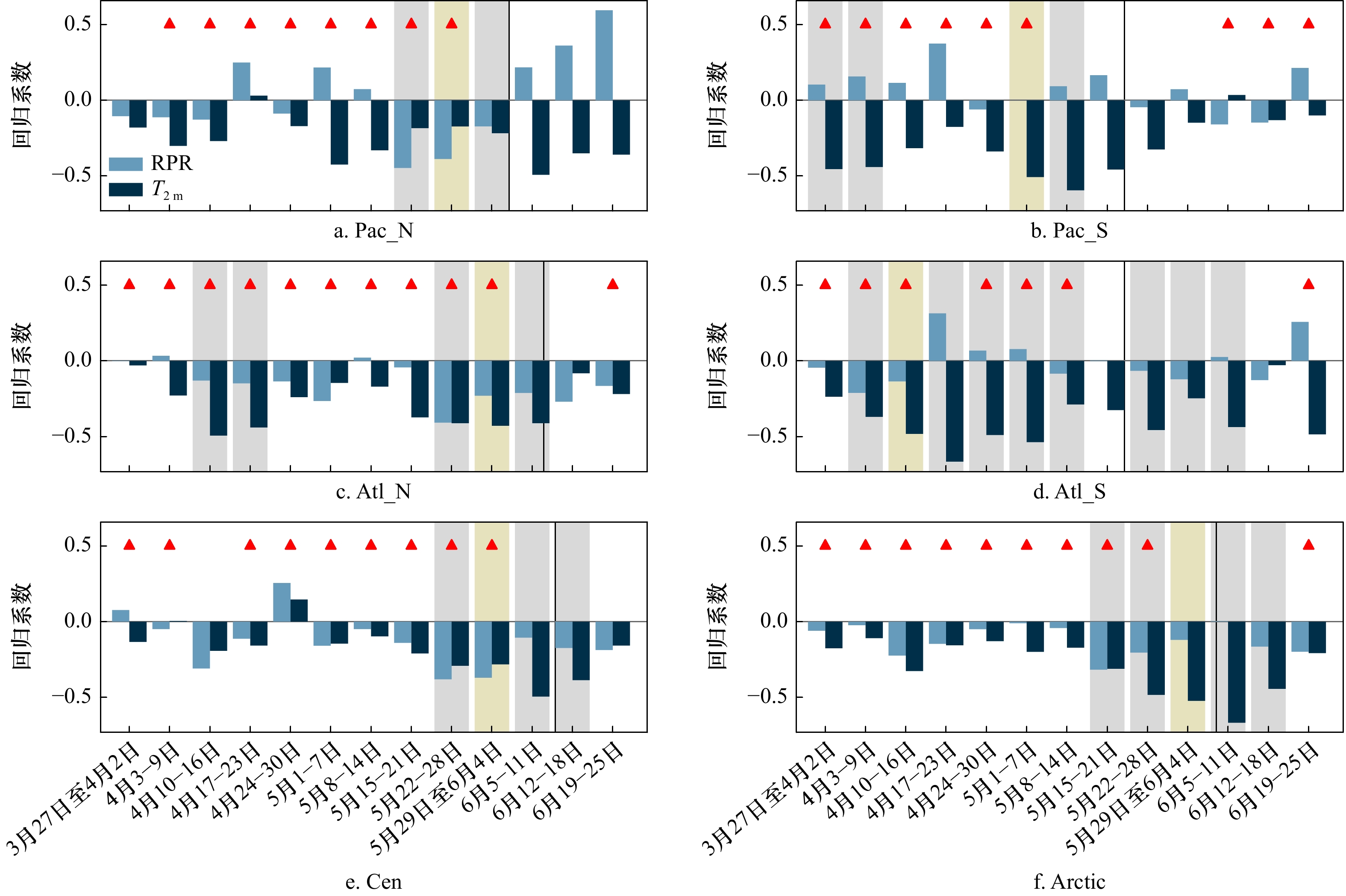
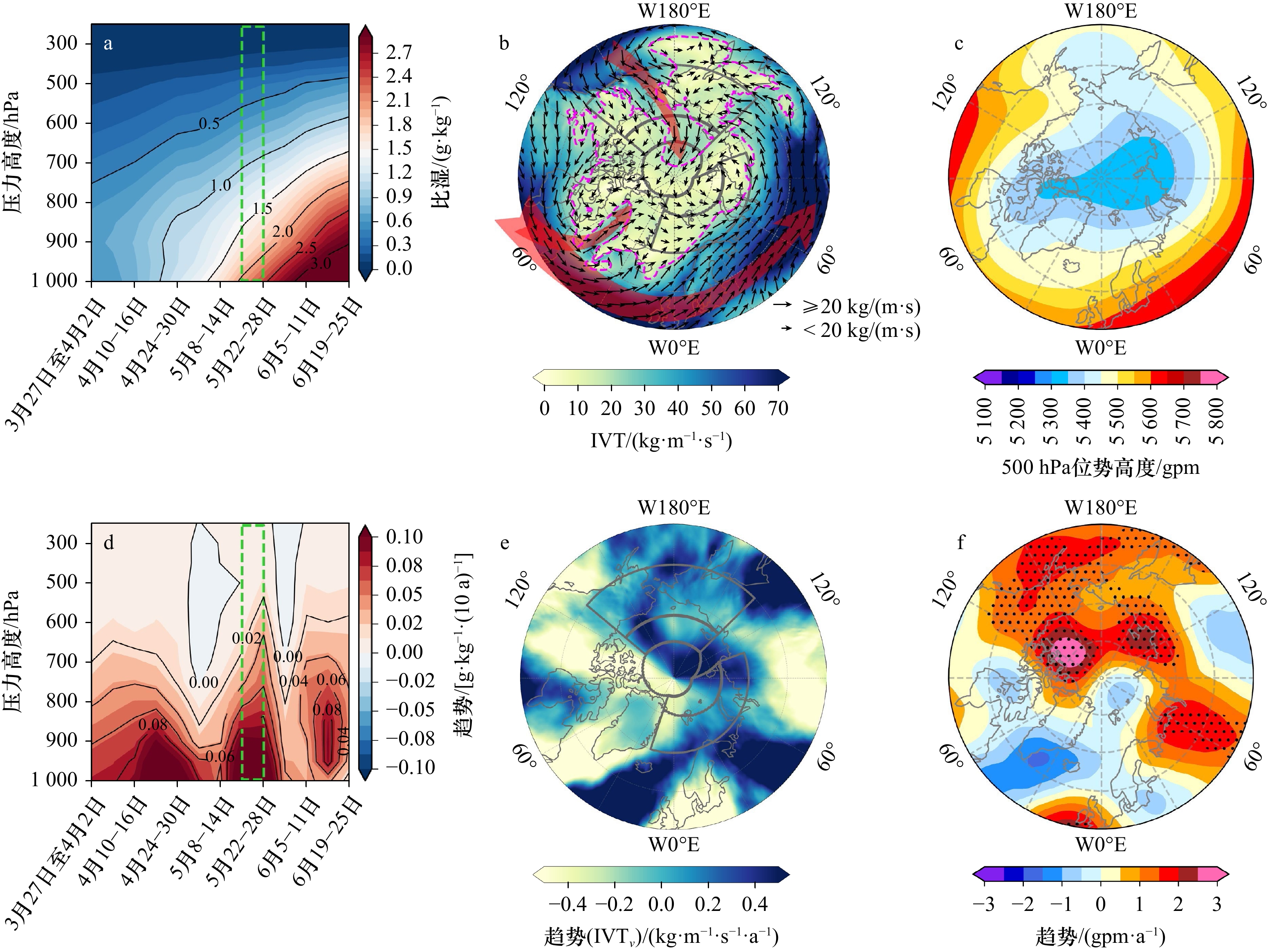
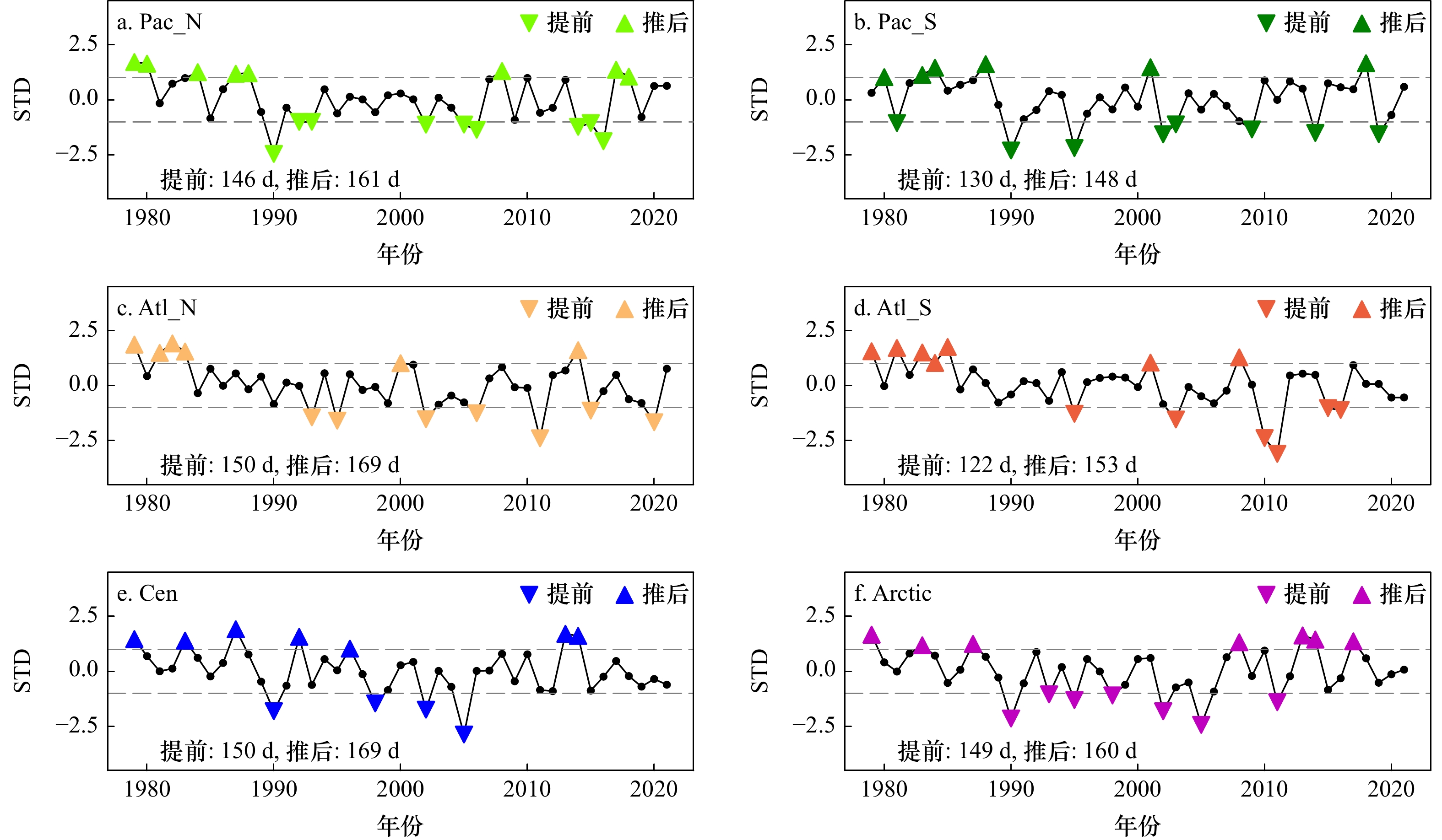
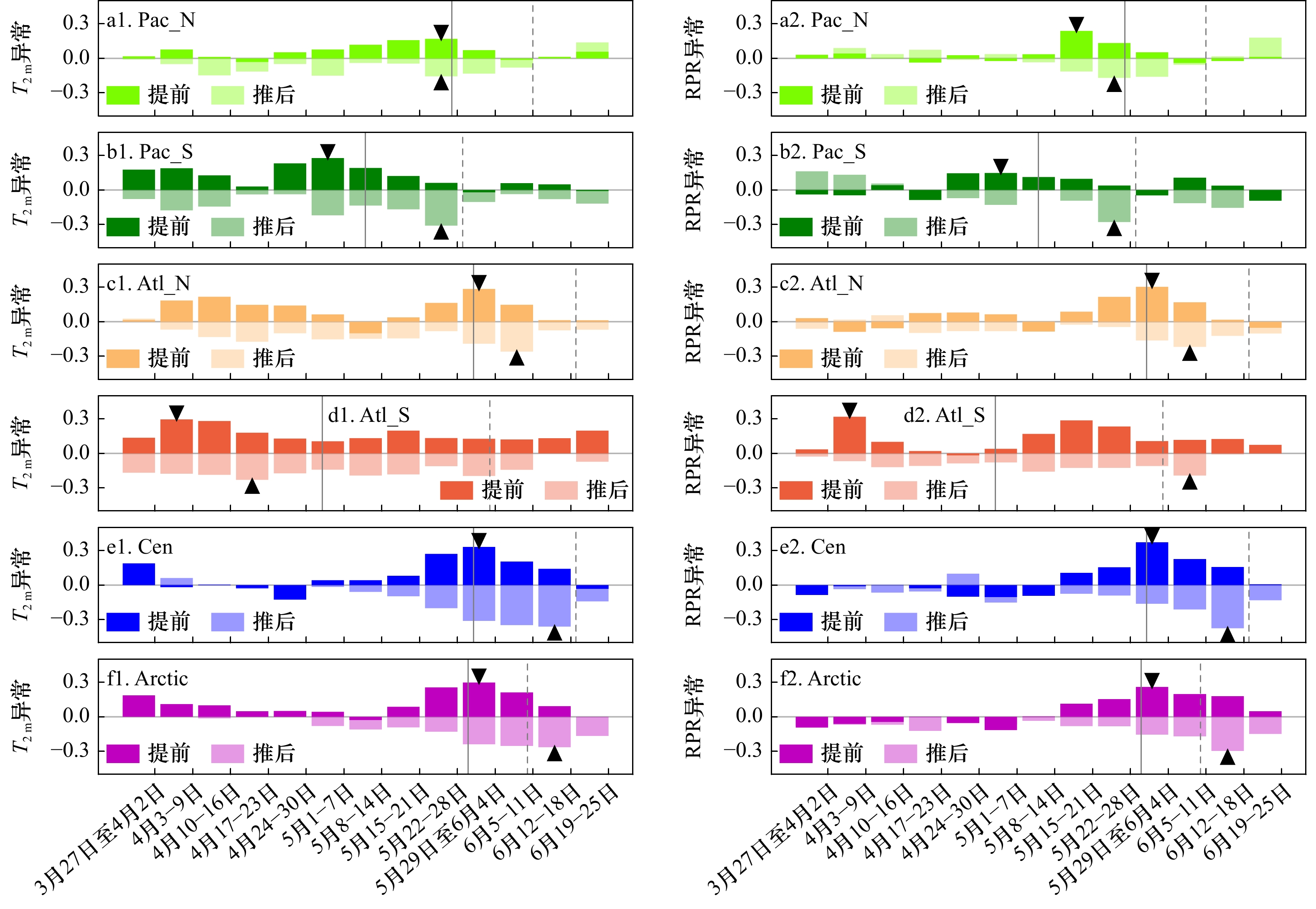
Early melt onset (EMO) is a crucial time index for sea ice melting and has a significant impact on the thermal balance of sea ice. In this paper, EMO remote sensing, ERA5 reanalysis, and sea ice concentration data have been used to reveal the relative contribution of surface air temperature and liquid precipitation. Our research indicates that, the most significant advancement of EMO is observed in the southern Atlantic sector among the five study sea areas from 1979−2021, with the rate of −3.3 d/(10 a). For the atmospheric factors affecting EMO, surface air temperature has a considerable correlation period lasting 1−2 months with EMO in all Arctic sea areas. In addition, surface air temperature in the southern Pacific sector and northern and southern Atlantic sectors have a longer duration and stronger correlation with EMO than liquid precipitation. However, for the northern Pacific sector and the central Arctic, liquid precipitation has a higher contribution only in the 2−3 weeks prior to EMO. For the northern Pacific sector, atmospheric circulation provides strong water vapor transport channel extends into this sea area, increasing saturated water vapor in the lower troposphere. Meanwhile, the trend of the 500 hPa potential height shows a three-wave strengthening atmospheric circulation structure around the pole, allowing meridional heat exchange and enhancing the vertical gradient of specific humidity, which promotes the advancement of EMO. For the central Arctic, in years when EMO is advanced, the liquid precipitation is 33% higher than climatology. Additionally, not only the Pacific water vapor transport in the climatology is enhanced, but also the converges with water vapor channel over Eurasia continent, contributing to the formation of cyclonic water vapor transport mode in the eastern Arctic, providing conditions for the advancement of EMO.
Early melt onset (EMO) is a crucial time index for sea ice melting and has a significant impact on the thermal balance of sea ice. In this paper, EMO remote sensing, ERA5 reanalysis, and sea ice concentration data have been used to reveal the relative contribution of surface air temperature and liquid precipitation. Our research indicates that, the most significant advancement of EMO is observed in the southern Atlantic sector among the five study sea areas from 1979−2021, with the rate of −3.3 d/(10 a). For the atmospheric factors affecting EMO, surface air temperature has a considerable correlation period lasting 1−2 months with EMO in all Arctic sea areas. In addition, surface air temperature in the southern Pacific sector and northern and southern Atlantic sectors have a longer duration and stronger correlation with EMO than liquid precipitation. However, for the northern Pacific sector and the central Arctic, liquid precipitation has a higher contribution only in the 2−3 weeks prior to EMO. For the northern Pacific sector, atmospheric circulation provides strong water vapor transport channel extends into this sea area, increasing saturated water vapor in the lower troposphere. Meanwhile, the trend of the 500 hPa potential height shows a three-wave strengthening atmospheric circulation structure around the pole, allowing meridional heat exchange and enhancing the vertical gradient of specific humidity, which promotes the advancement of EMO. For the central Arctic, in years when EMO is advanced, the liquid precipitation is 33% higher than climatology. Additionally, not only the Pacific water vapor transport in the climatology is enhanced, but also the converges with water vapor channel over Eurasia continent, contributing to the formation of cyclonic water vapor transport mode in the eastern Arctic, providing conditions for the advancement of EMO.


2023, 45(9): 25-44.
doi: 10.12284/hyxb2023112
Abstract:
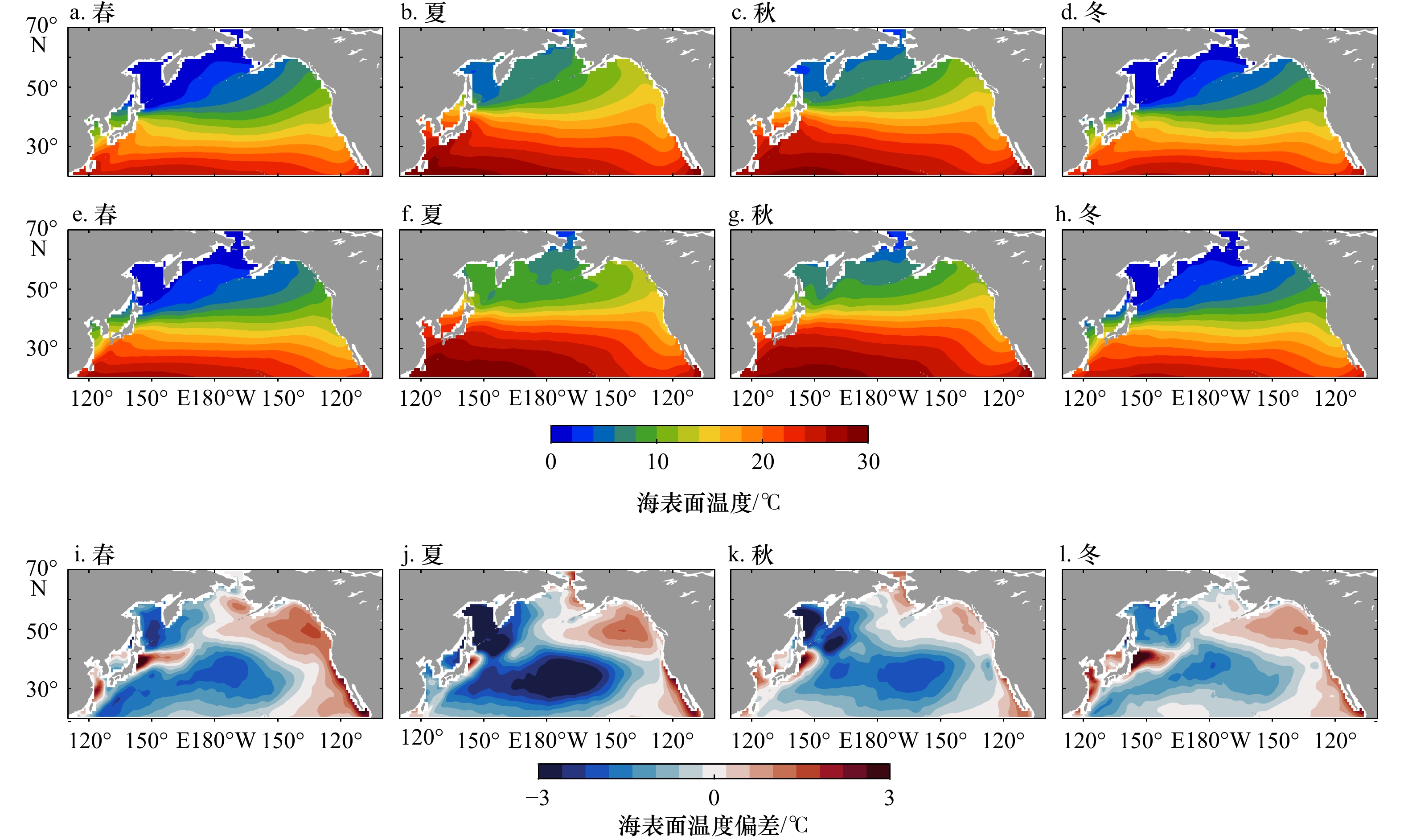
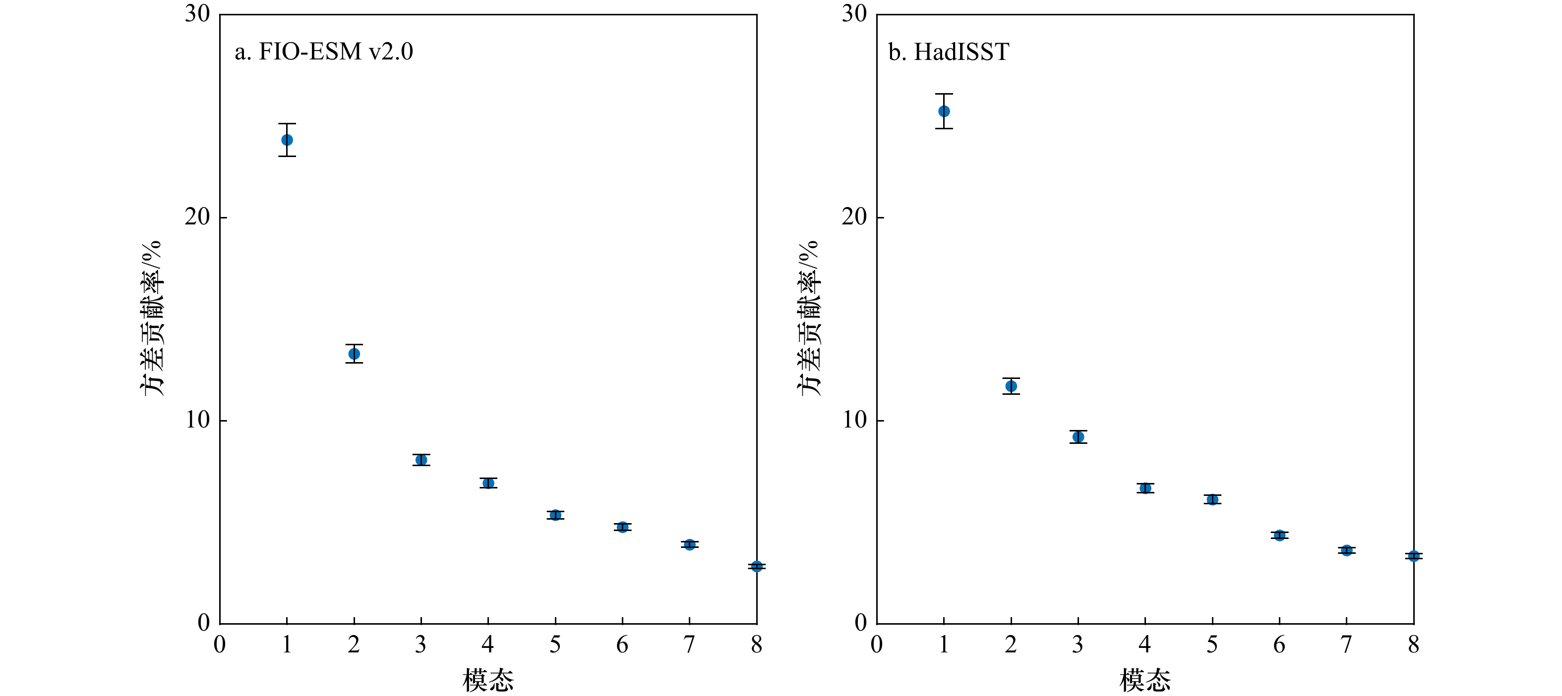
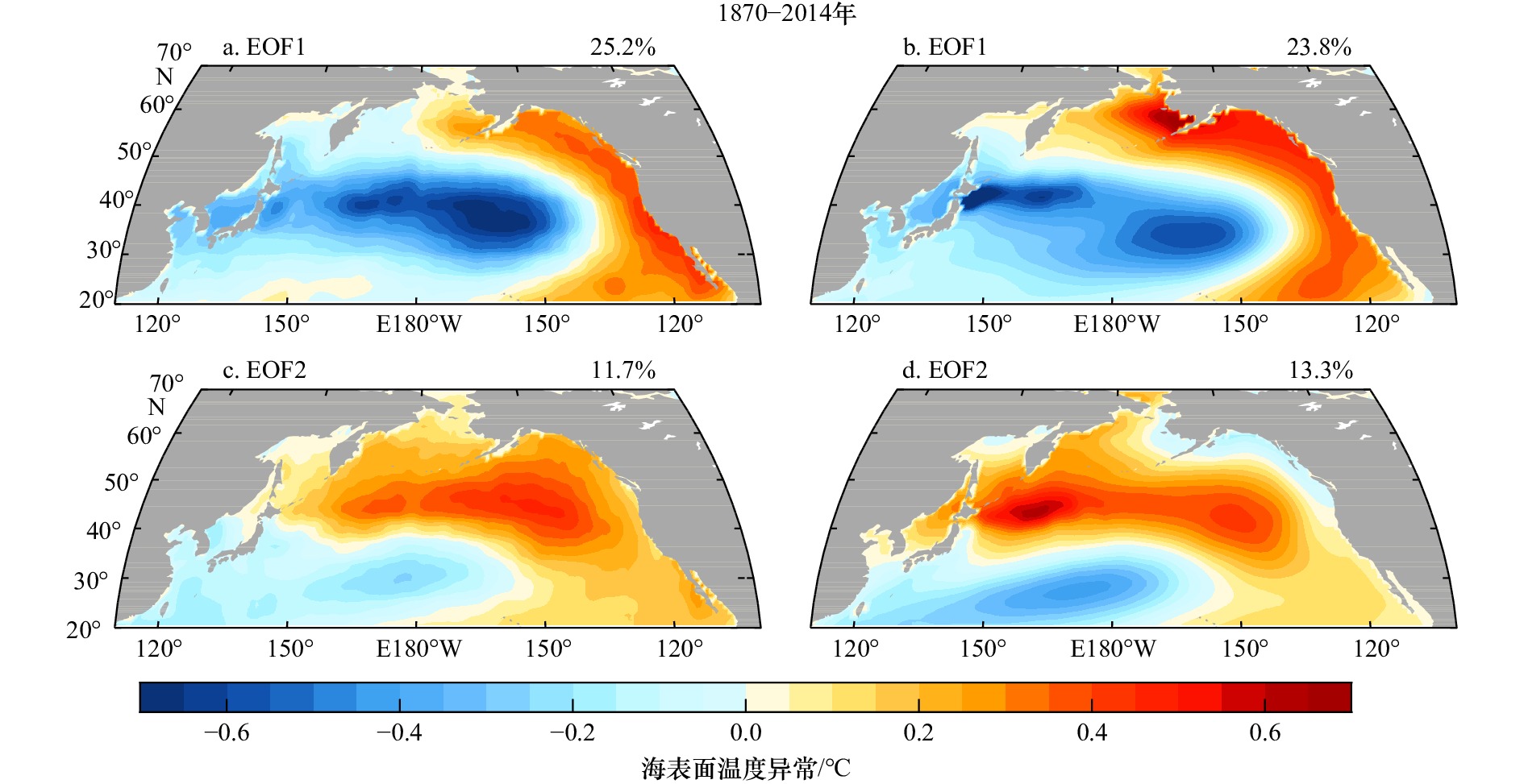
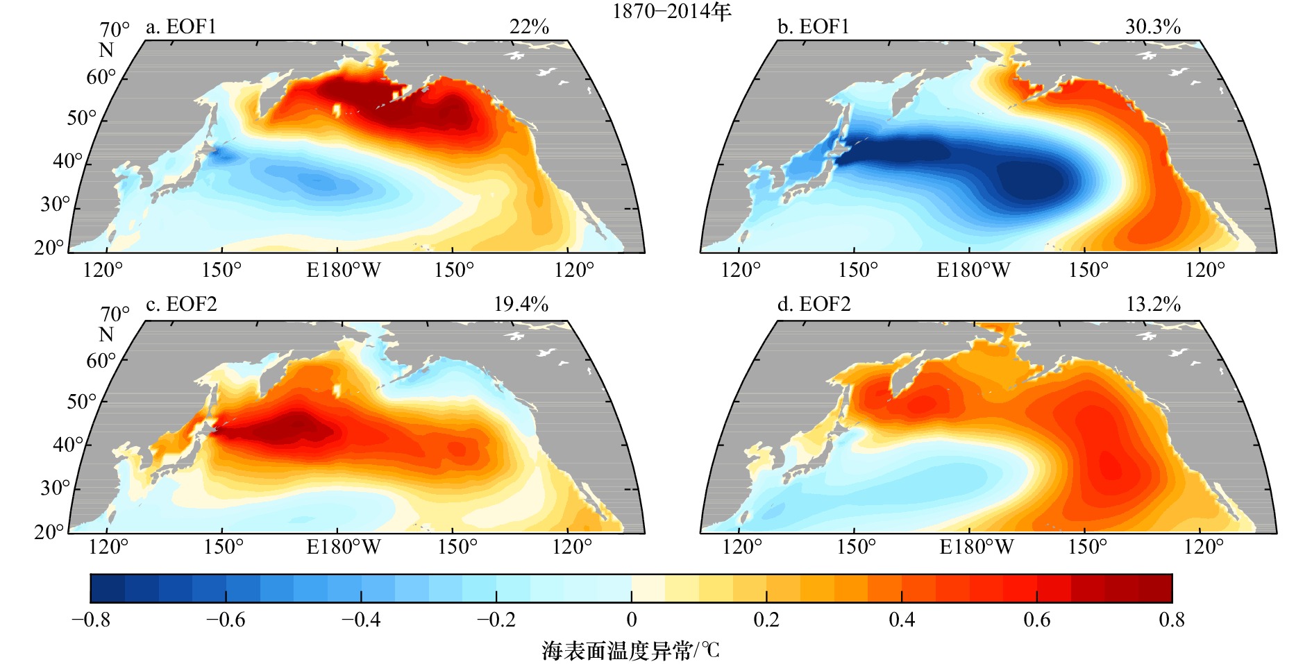
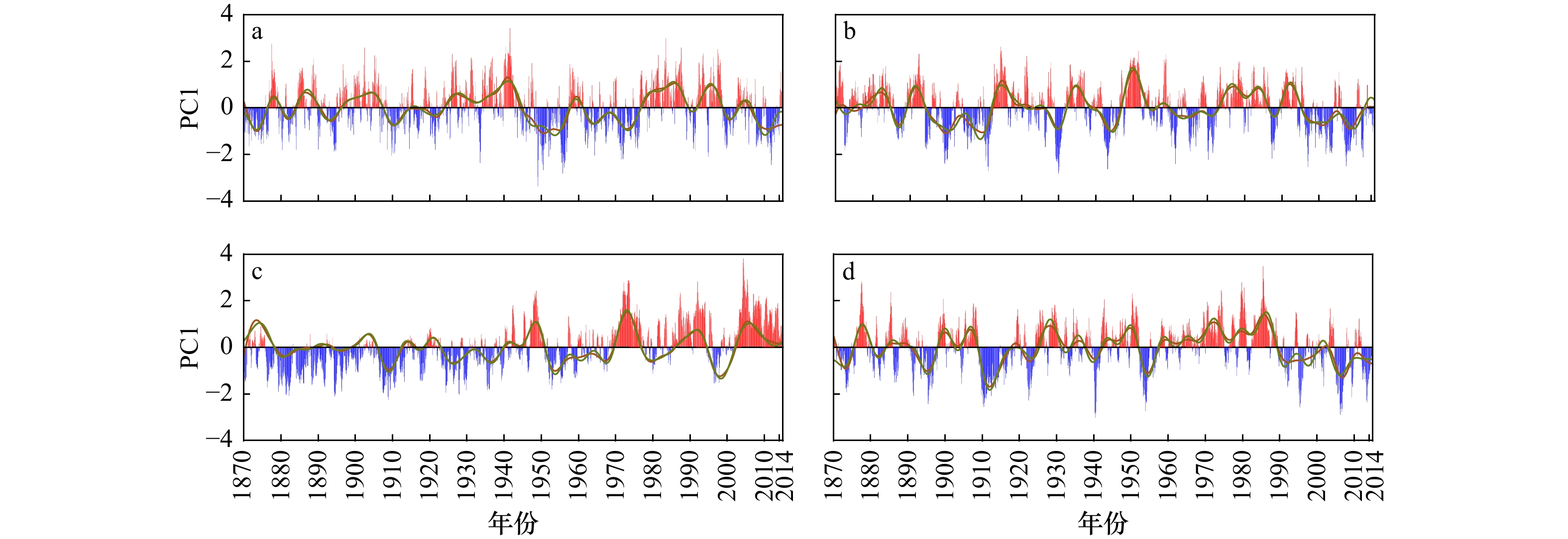
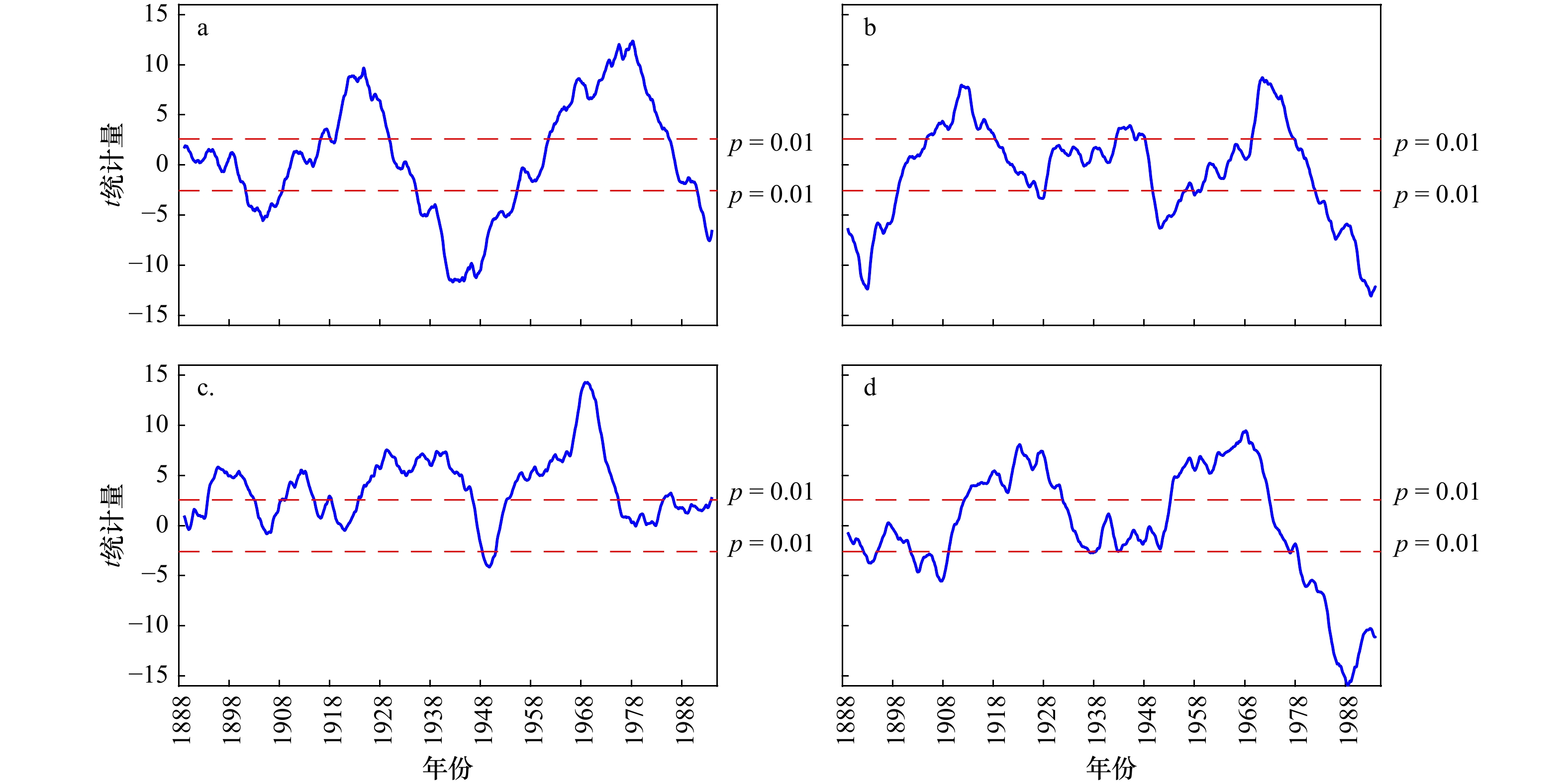
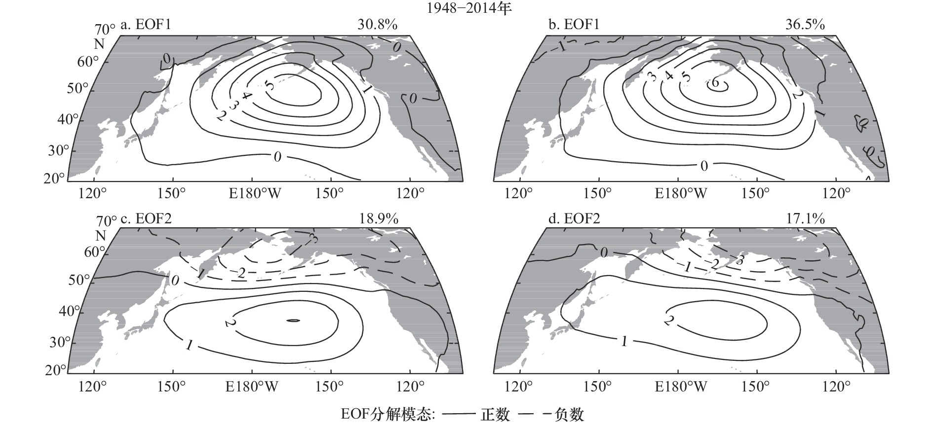
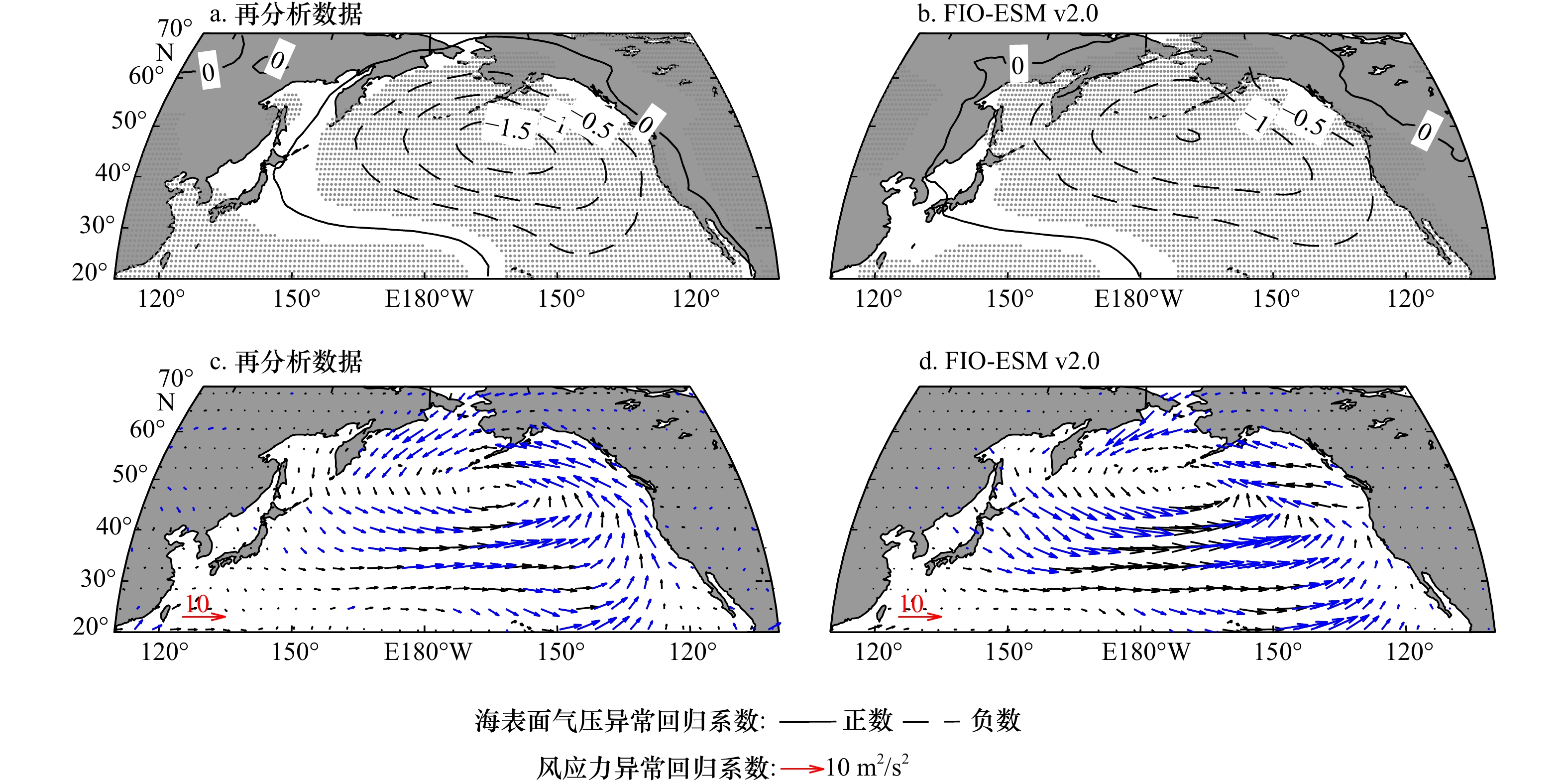
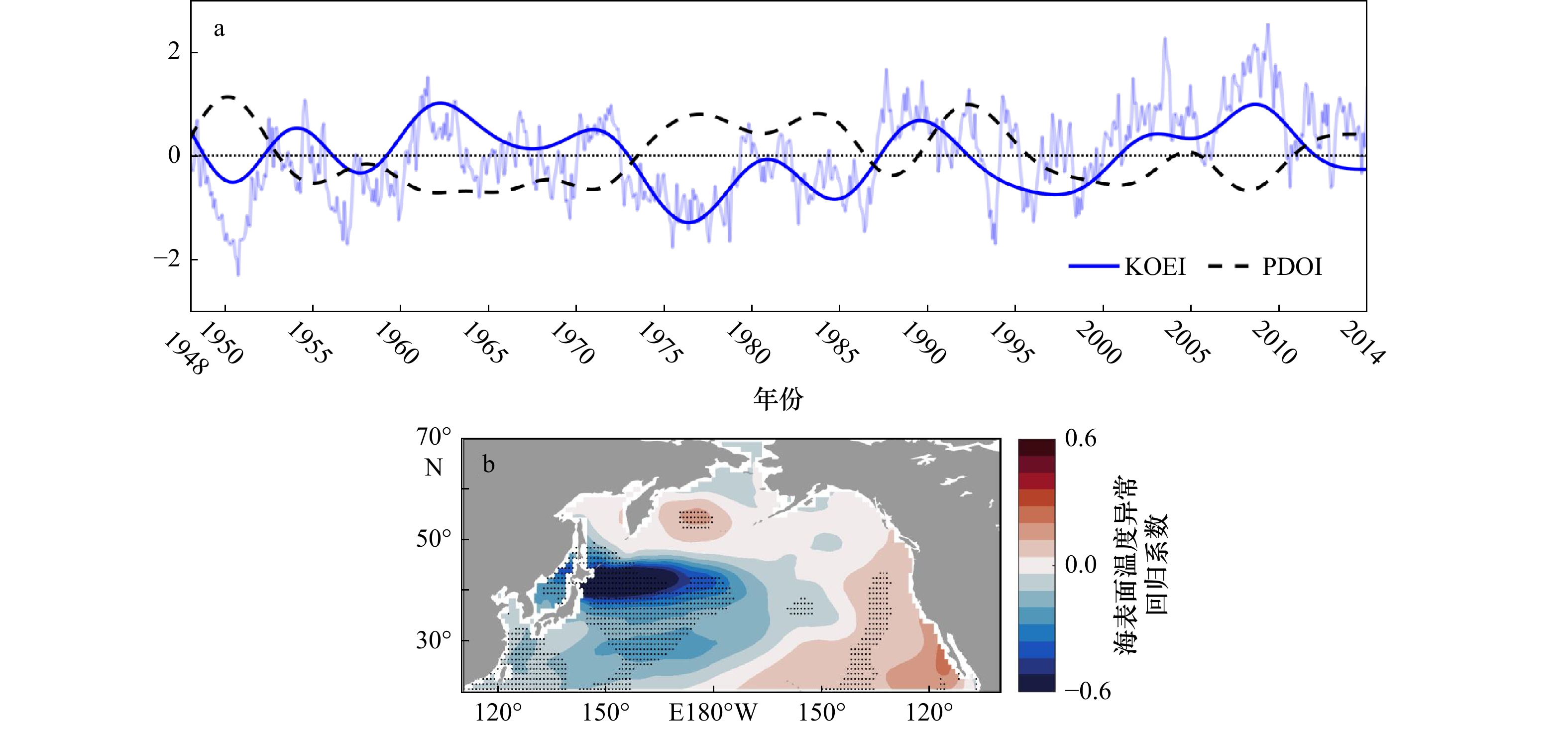
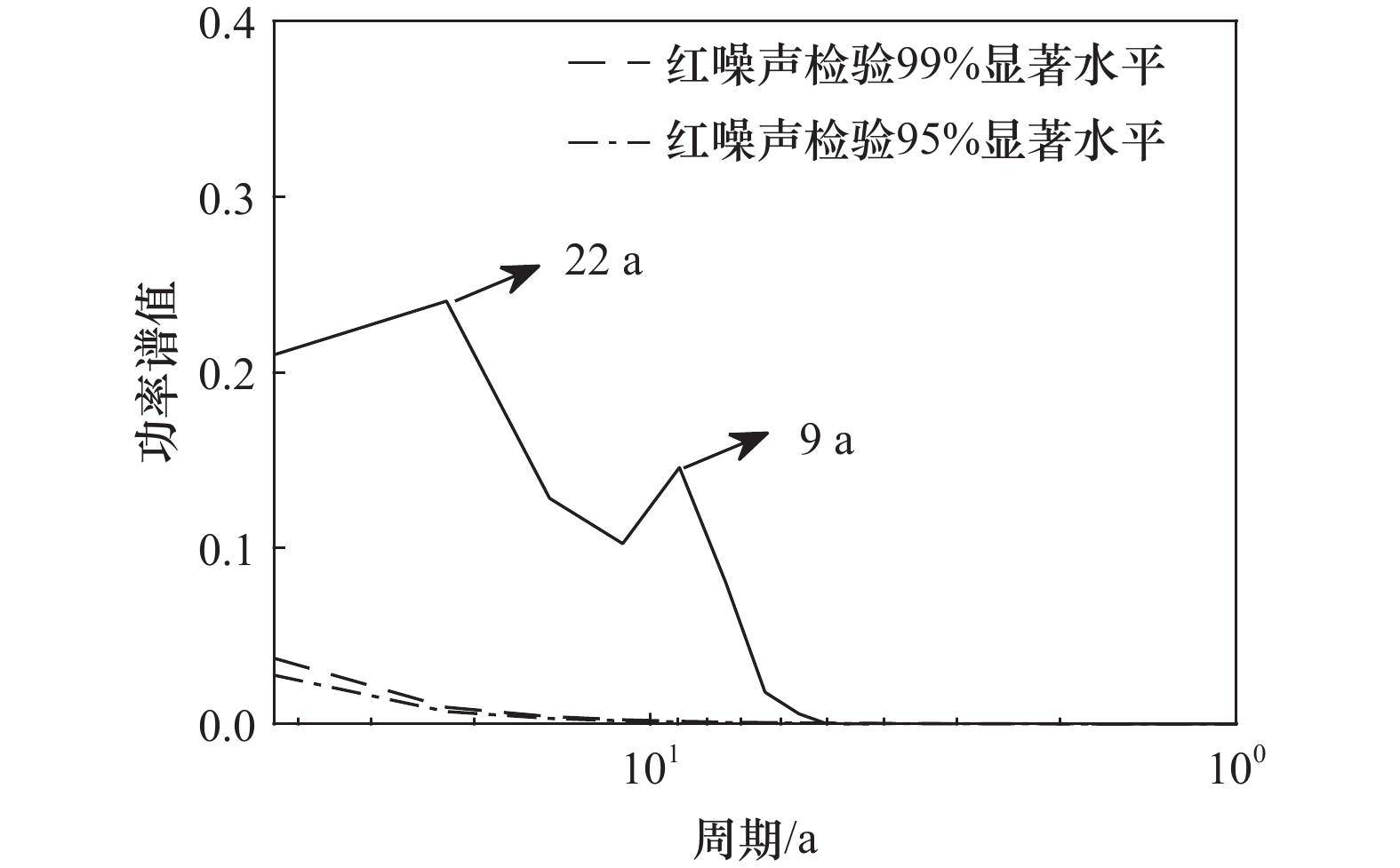
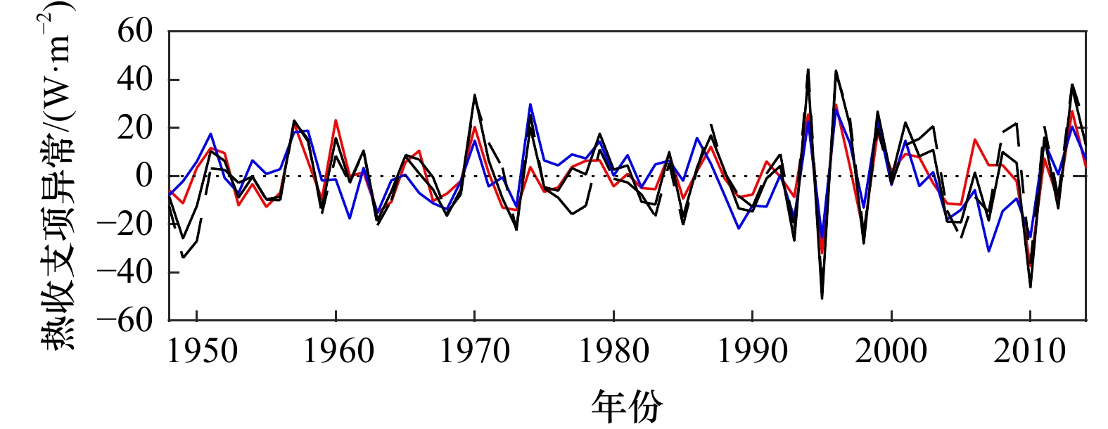
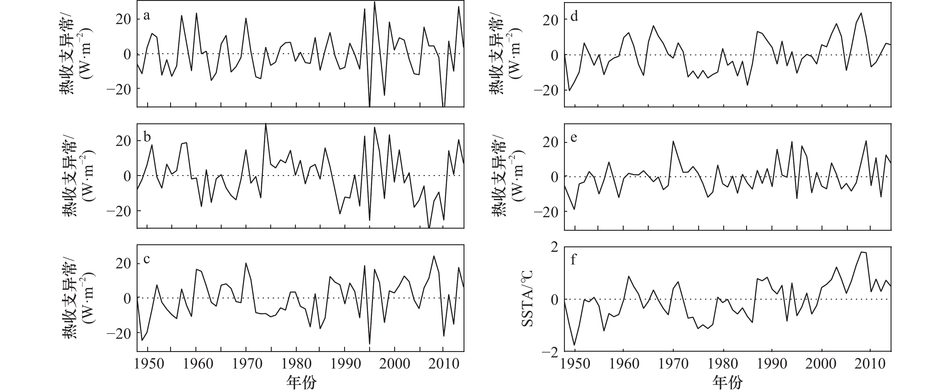
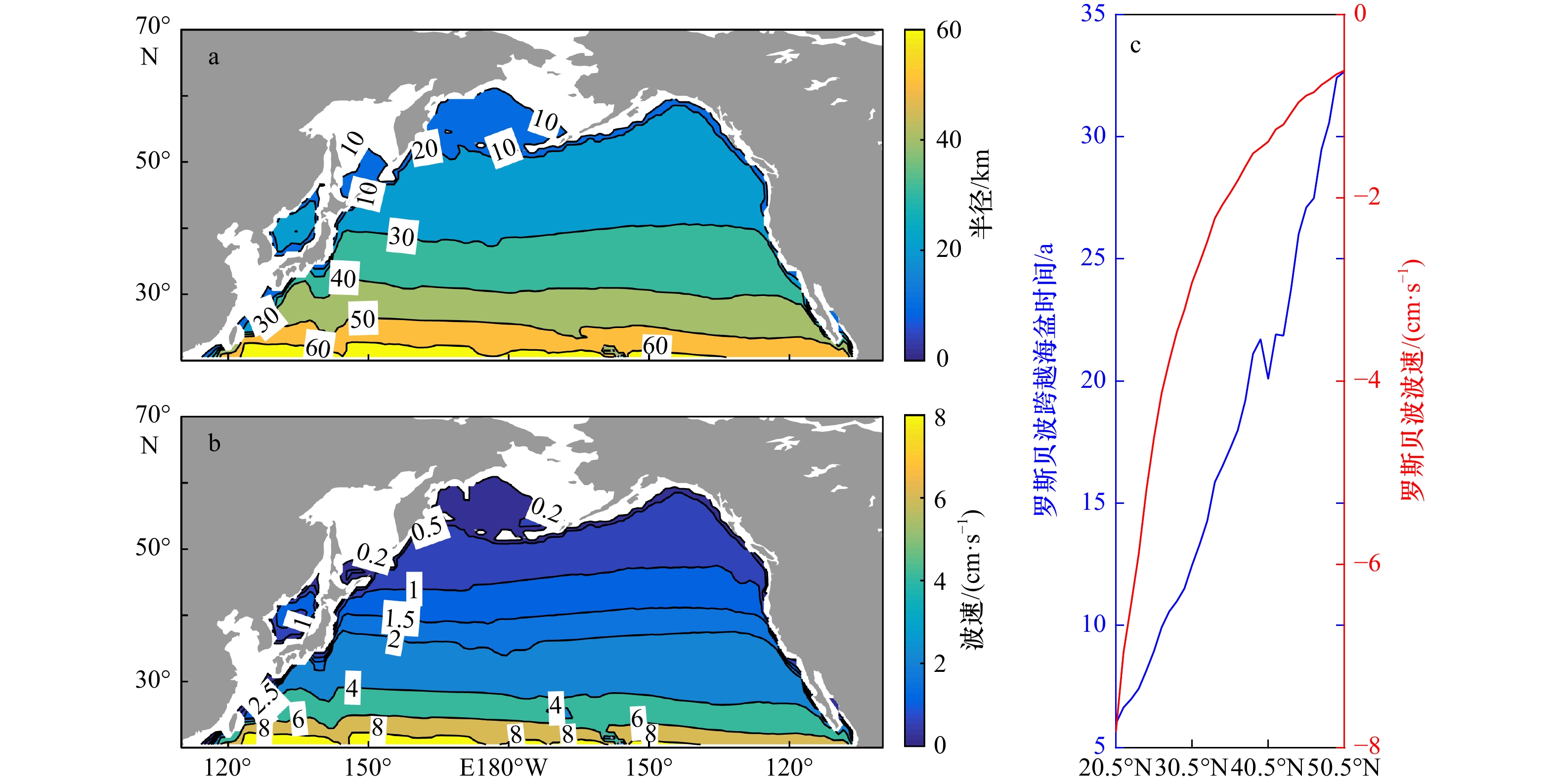
Numerical simulation play an important role in studying long-term climate change. For a long time, it has meted great challenges in characterizing the phase transitions of interdecadal climate changes like Pacific Decadal Oscillation (PDO). This study evaluates 145-year (1870–2014) historical PDO simulation results produced by the First Institute of Oceanography’s Earth System Model Version 2 (FIO-ESM v2.0) of Ministry of Natural Resources, in a comparison with reanalysis datasets and two other earth system model results. Results indicate that the FIO-ESM v2.0 can recreate the spatial modal distribution characteristics of the PDO from the historical period. The model’s PDO index has a period of 10 to 30 years and can describe the phase transition characteristics that resembles reanalysis datasets after 1960. Research shows that the FIO-ESM v2.0 can describe the phase transition features of PDO well. In addition, the model performance to simulate atmospheric circulation modes and relationship with PDO, as well as the possible mechanism for the model to simulate PDO are also discussed. The PDO of the model is related to the Aleutian Mode of atmospheric circulation. Further analysis shows that advection and heat flux are the main factors affecting the amplitude of SST anomalies in key decadal area, and the Rossby wave westward time may be the key factor affecting the phase transition of PDO.
Numerical simulation play an important role in studying long-term climate change. For a long time, it has meted great challenges in characterizing the phase transitions of interdecadal climate changes like Pacific Decadal Oscillation (PDO). This study evaluates 145-year (1870–2014) historical PDO simulation results produced by the First Institute of Oceanography’s Earth System Model Version 2 (FIO-ESM v2.0) of Ministry of Natural Resources, in a comparison with reanalysis datasets and two other earth system model results. Results indicate that the FIO-ESM v2.0 can recreate the spatial modal distribution characteristics of the PDO from the historical period. The model’s PDO index has a period of 10 to 30 years and can describe the phase transition characteristics that resembles reanalysis datasets after 1960. Research shows that the FIO-ESM v2.0 can describe the phase transition features of PDO well. In addition, the model performance to simulate atmospheric circulation modes and relationship with PDO, as well as the possible mechanism for the model to simulate PDO are also discussed. The PDO of the model is related to the Aleutian Mode of atmospheric circulation. Further analysis shows that advection and heat flux are the main factors affecting the amplitude of SST anomalies in key decadal area, and the Rossby wave westward time may be the key factor affecting the phase transition of PDO.


2023, 45(9): 45-57.
doi: 10.12284/hyxb2023116
Abstract:
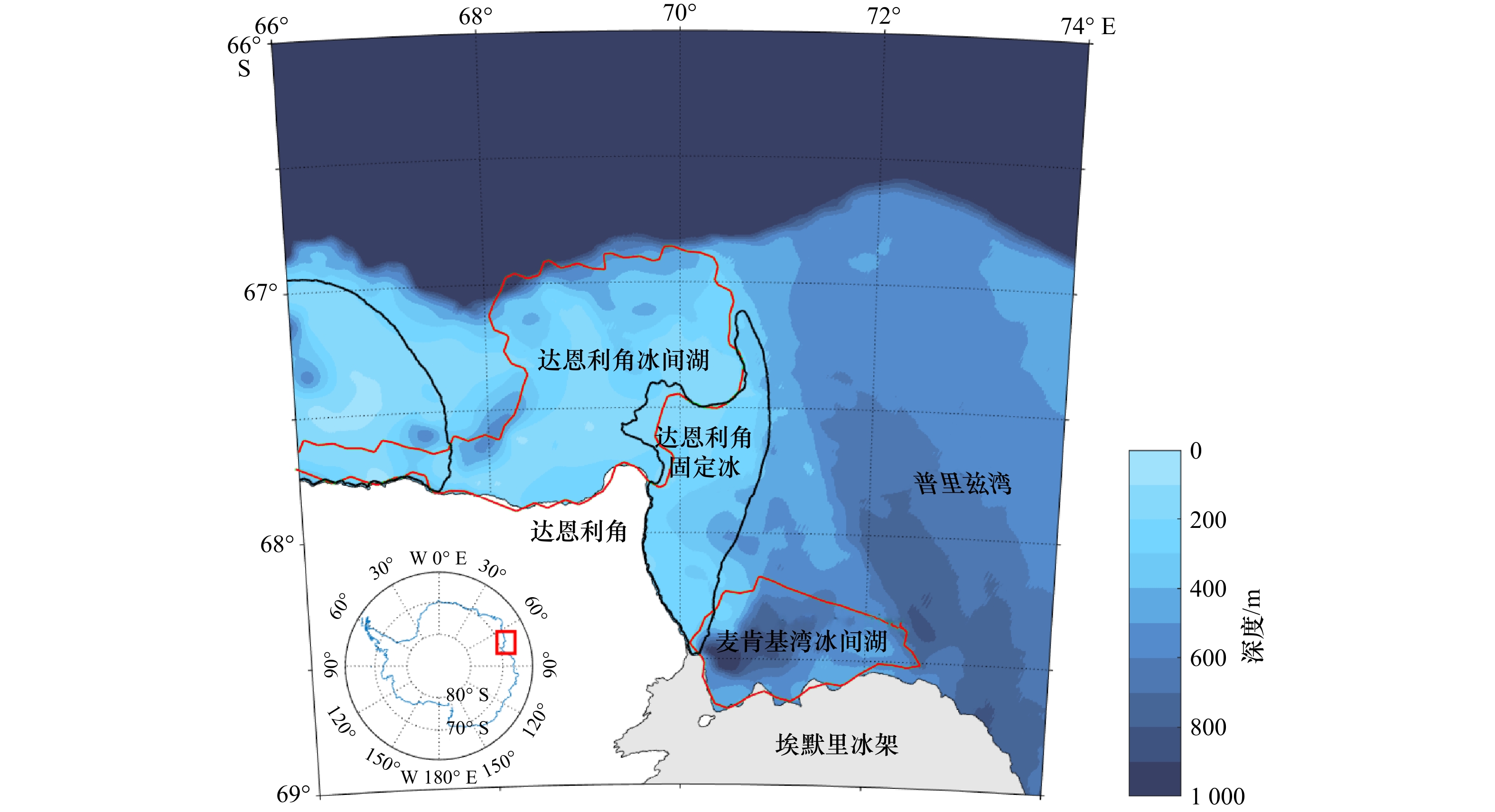
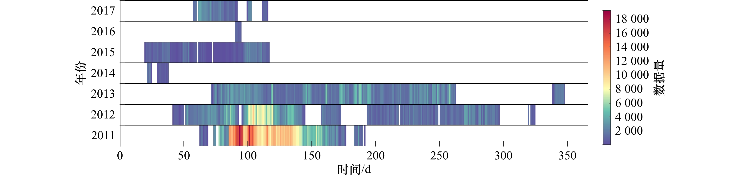
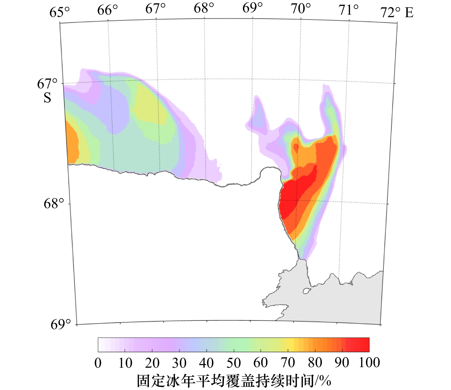
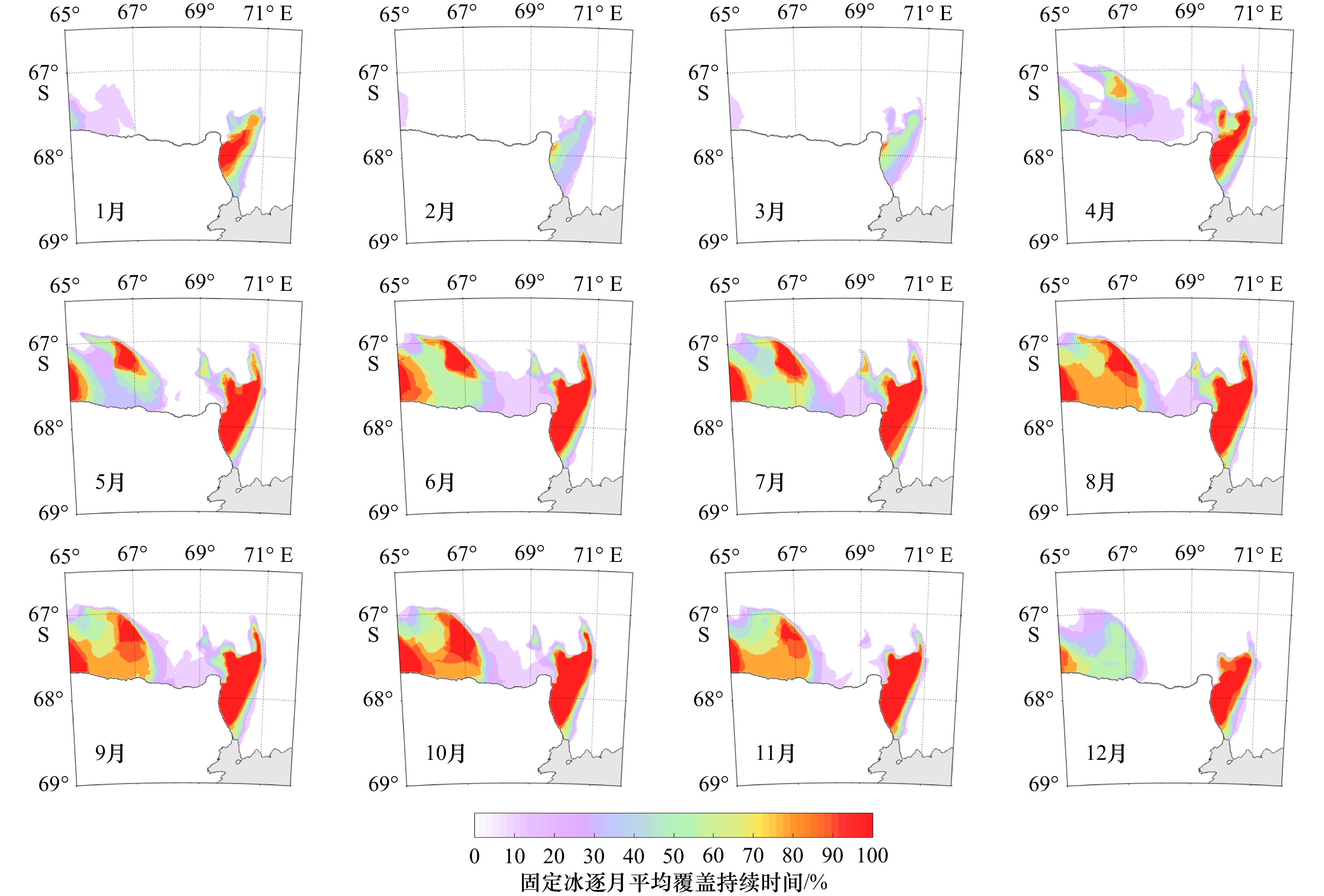
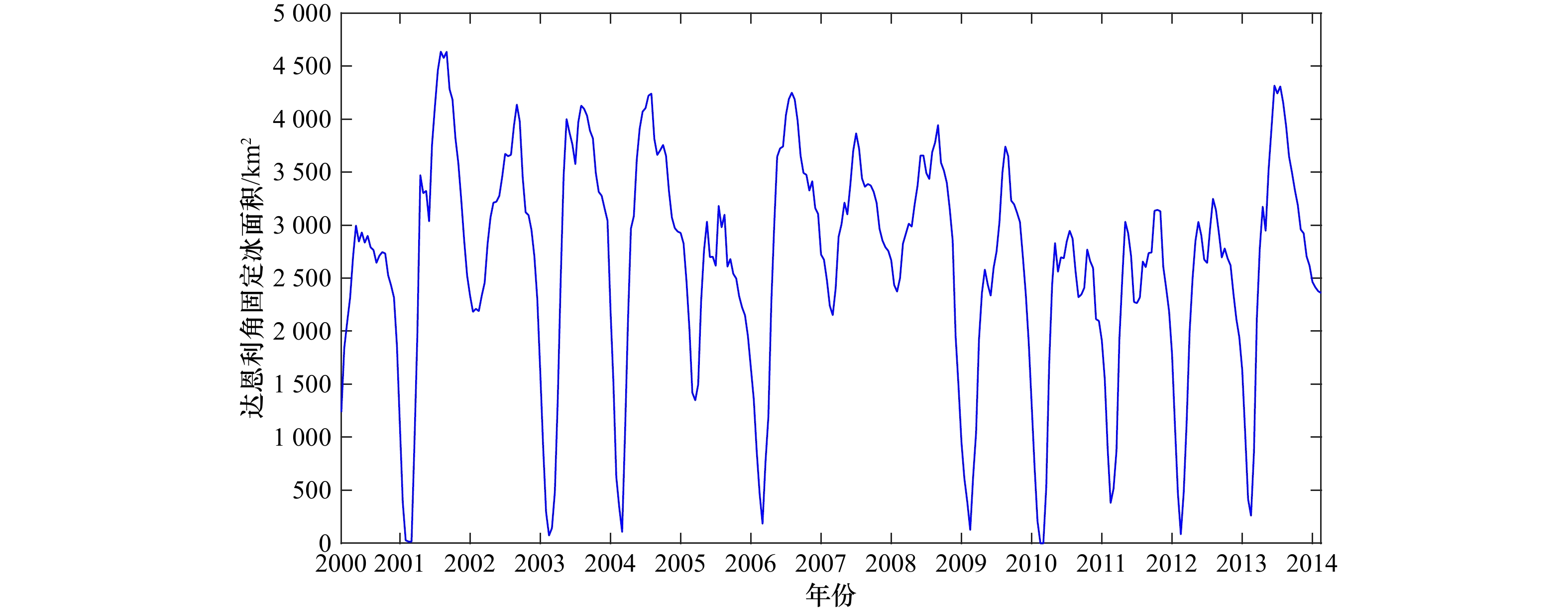
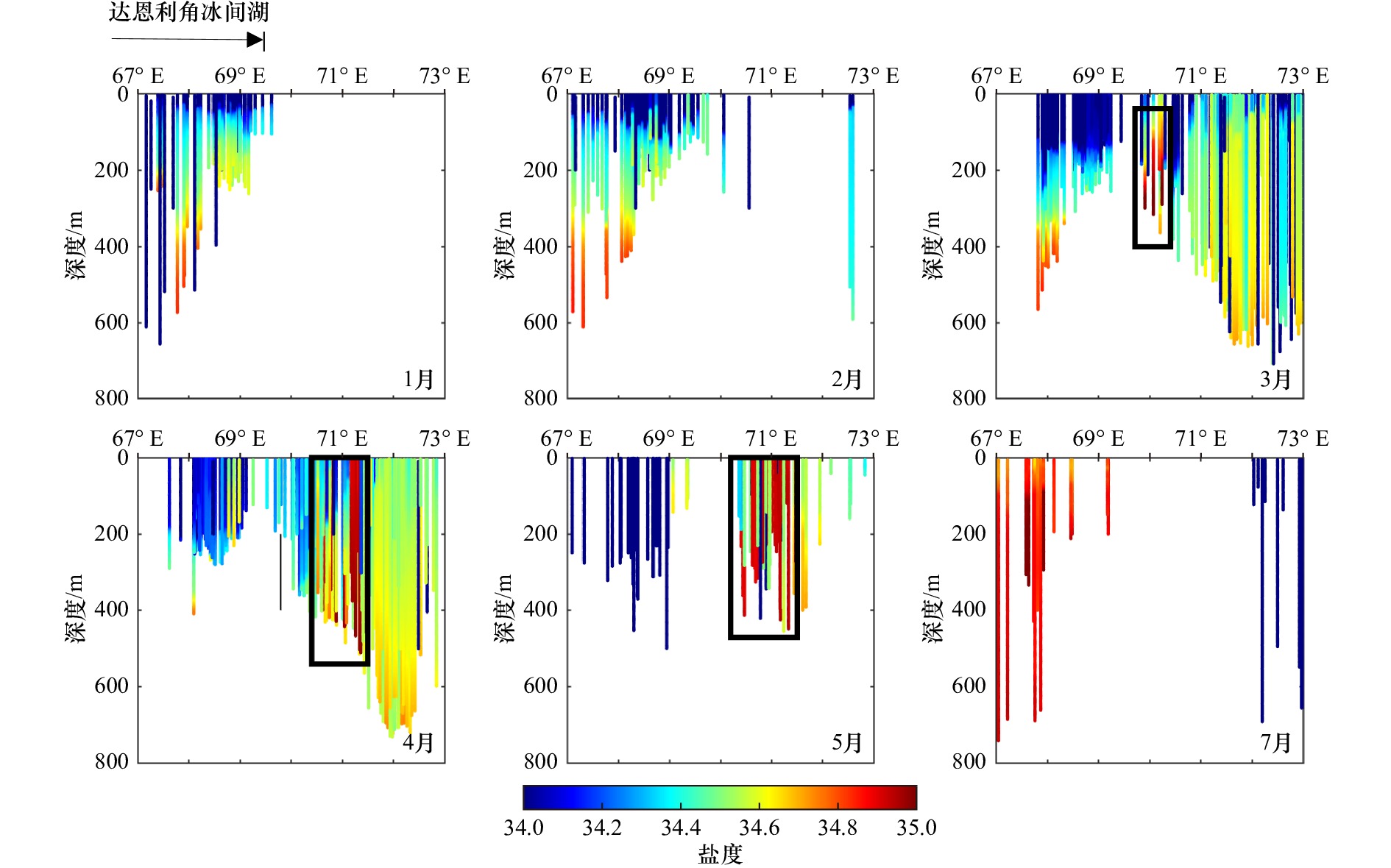
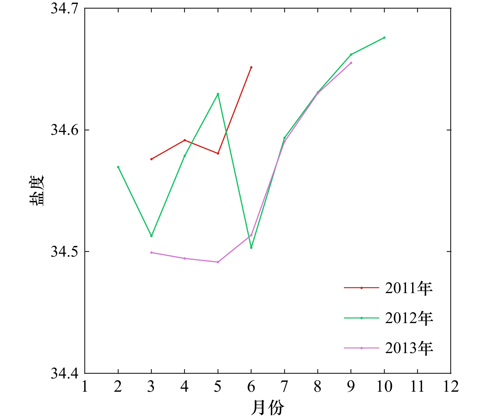
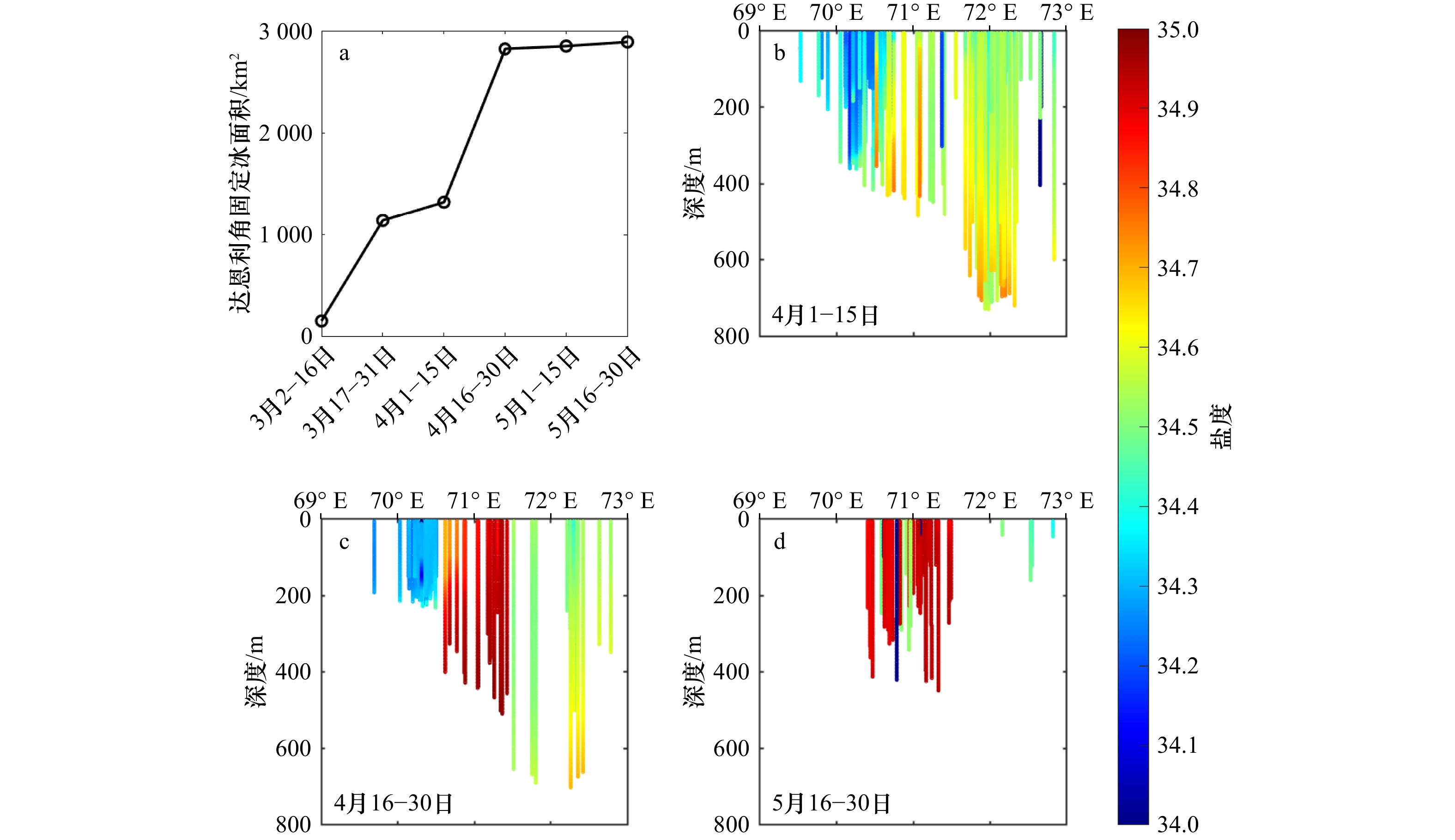
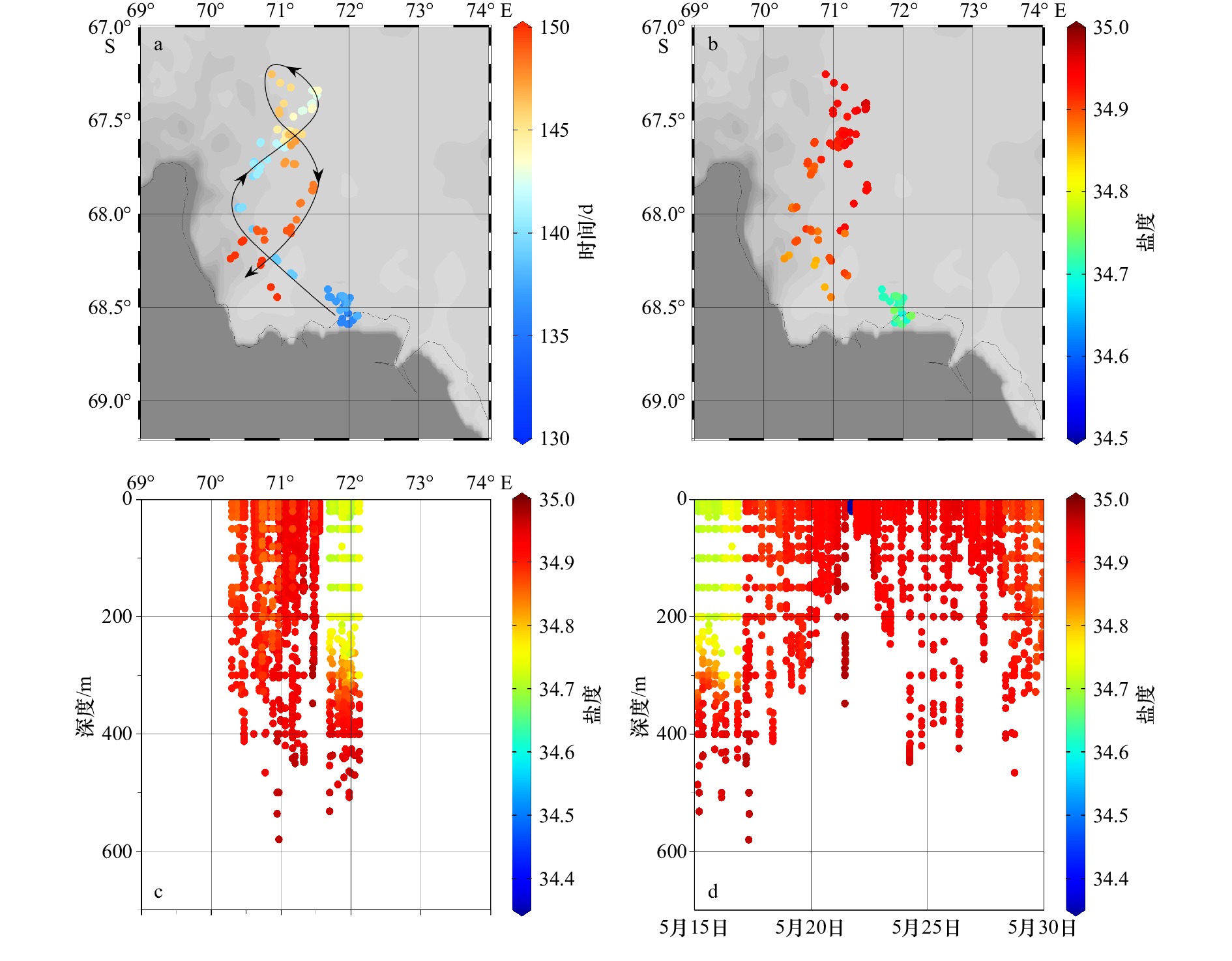
In this paper, we analyze the variation of local dense shelf water around the Cape Darnley fast ice by using a landfast ice dataset and in-situ observation data of Antarctic elephant seals. The results show that: firstly, there are significant seasonal variations of Cape Darnley fast ice, which has a vital impact on the formation of the Cape Darnley polynya and the local dense shelf water. Secondly, the interannual variation of Cape Darnley fast ice is minimal from 2000 to 2014, with no significant trend of increasing or decreasing. Thirdly, we identify two significant sources of local dense shelf water near the Cape Darnley fast ice area: (1) dense shelf water produced by the strong brine rejection process during the rapid generation of Cape Darnley fast ice from March to April; (2) Cape Darnley fast ice reaching its maximum extent and local brine rejection being reduced to a minimum in May. After the weakening of the inhibition of ice shelf water, the formation of dense shelf water in the upstream MacKenzie Bay polynya is enhanced and transported northwest to the vicinity of the Cape Darnley fast ice. In this study, we preliminarily demonstrates that, in addition to maintaining Cape Darnley polynya, Cape Darnley fast ice probably has an important influence on the generation of local dense shelf water, and points out an important water mass transport path. These would help improve the comprehension of ice-sea interaction near Cape Darnley and point out the need for more observations or modeling studies in this area.
In this paper, we analyze the variation of local dense shelf water around the Cape Darnley fast ice by using a landfast ice dataset and in-situ observation data of Antarctic elephant seals. The results show that: firstly, there are significant seasonal variations of Cape Darnley fast ice, which has a vital impact on the formation of the Cape Darnley polynya and the local dense shelf water. Secondly, the interannual variation of Cape Darnley fast ice is minimal from 2000 to 2014, with no significant trend of increasing or decreasing. Thirdly, we identify two significant sources of local dense shelf water near the Cape Darnley fast ice area: (1) dense shelf water produced by the strong brine rejection process during the rapid generation of Cape Darnley fast ice from March to April; (2) Cape Darnley fast ice reaching its maximum extent and local brine rejection being reduced to a minimum in May. After the weakening of the inhibition of ice shelf water, the formation of dense shelf water in the upstream MacKenzie Bay polynya is enhanced and transported northwest to the vicinity of the Cape Darnley fast ice. In this study, we preliminarily demonstrates that, in addition to maintaining Cape Darnley polynya, Cape Darnley fast ice probably has an important influence on the generation of local dense shelf water, and points out an important water mass transport path. These would help improve the comprehension of ice-sea interaction near Cape Darnley and point out the need for more observations or modeling studies in this area.


2023, 45(9): 58-71.
doi: 10.12284/hyxb2023145
Abstract:
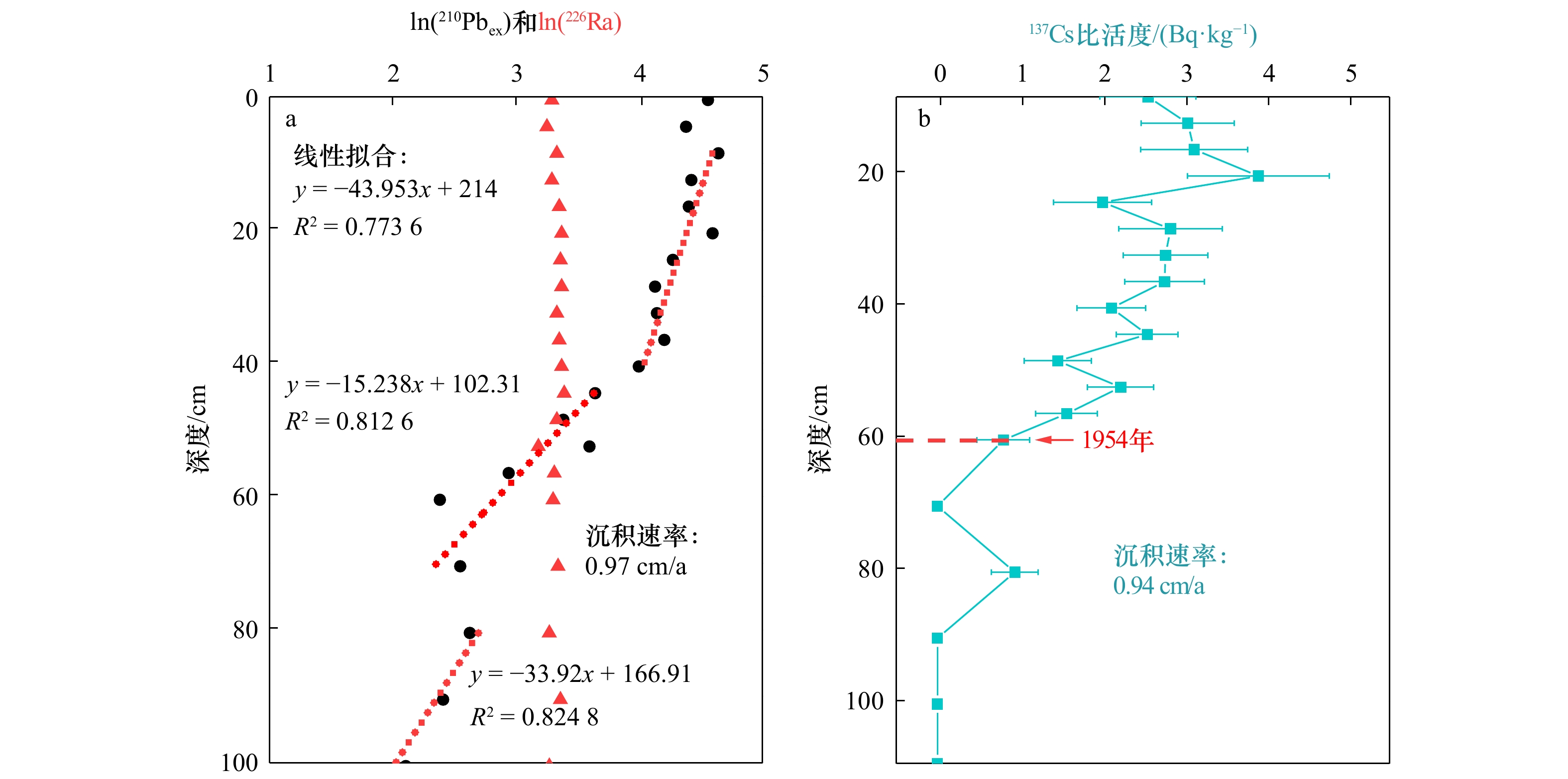
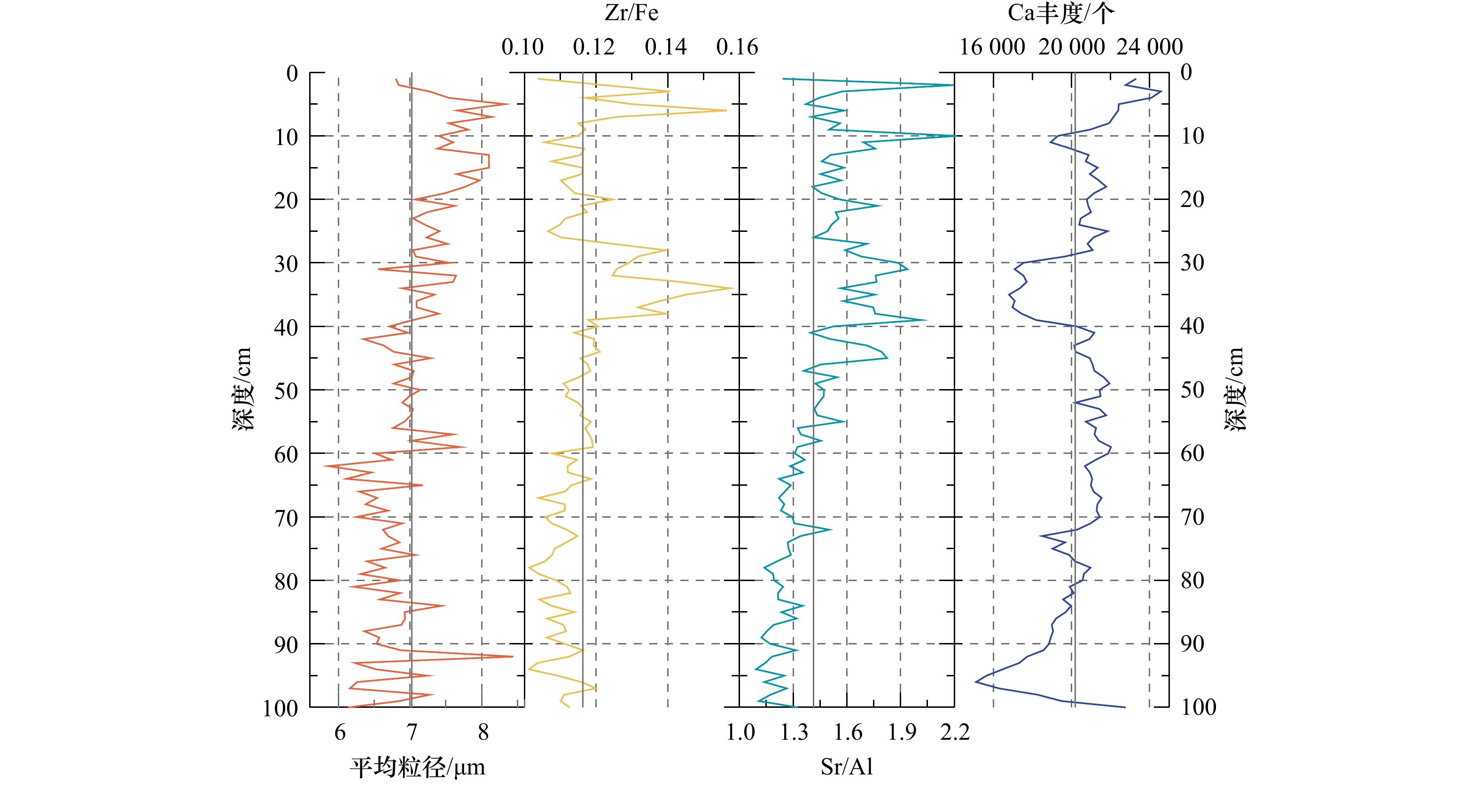
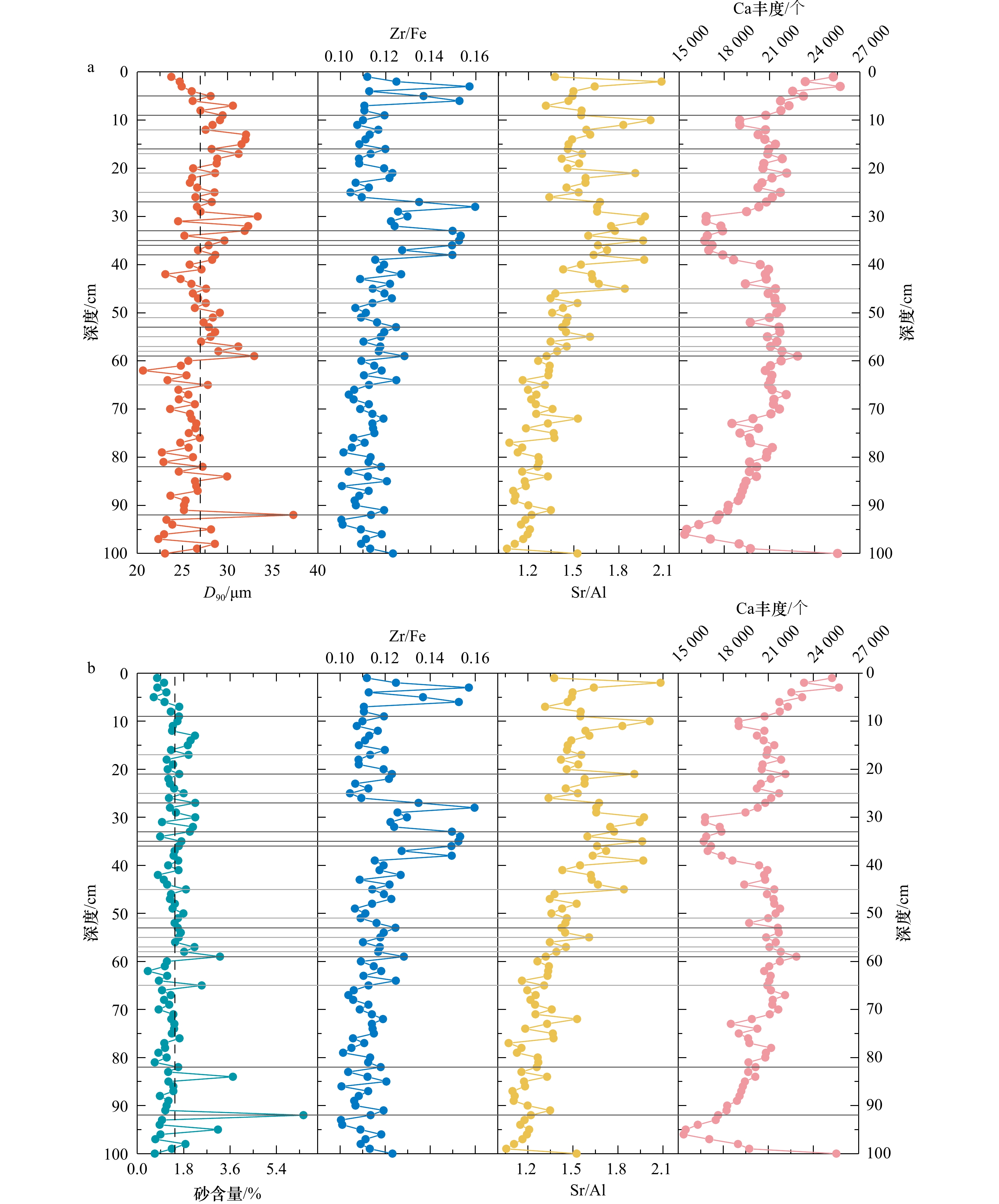
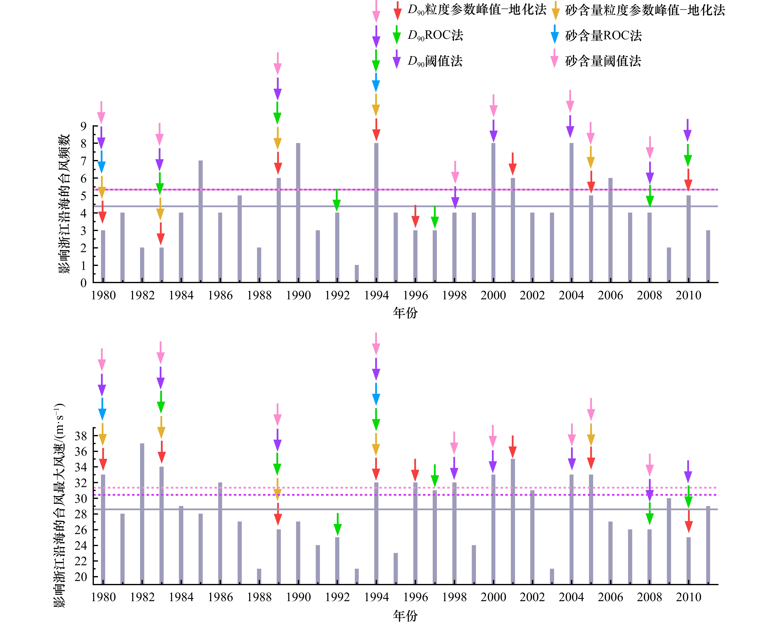
Typhoons are one of the major global environmental disasters, and their variability is of great concern to modern society. However, the variability of typhoon activity and its climate drivers on centennial-millennial scales are less clear due to the lack of atmospheric instrumental records before the mid-19th century. Coastal sedimentary archives provide a means to extend our knowledge of typhoon dynamics, of which the effective identification of typhoon event layers is an important foundation. Although many studies have attempted to reconstruct typhoon activity on long time scales using various indicators and methods, there is still a lack of evaluation of the effectiveness of these indicators and methods for the identification of typhoon event layer. In this study, a high-resolution sedimentary record (Core ZM02) from the muddy belt of inner shelf of the East China Sea was used, and its dating framework was determined using 210Pb and 137Cs dating methods. The instrumental and sedimentary records were then coupled to analyze the correspondence between typhoon intensity and frequency and sensitivity indicators of typhoon deposits (i.e., sand content and D90 in this study). The results show that the upper 4.5−100 cm of the core dates between 1917 and 2011 AD at a sedimentation rate of 0.97 cm/a. Among the three technical solutions, the threshold method was found to have the best identification and highest stability. Both sand content and D90 were found to be effective indicators for the identification of typhoon deposits in the study area. Sand content may be a potential indicator of typhoon intensity variation along the Zhejiang coast, and D90 contains information on typhoon frequency. The knowledge obtained here will not only contribute to the more accurate use of the sedimentary record to extend the time span of the typhoon record, but also to improve the ability to decipher information from the sedimentary record.
Typhoons are one of the major global environmental disasters, and their variability is of great concern to modern society. However, the variability of typhoon activity and its climate drivers on centennial-millennial scales are less clear due to the lack of atmospheric instrumental records before the mid-19th century. Coastal sedimentary archives provide a means to extend our knowledge of typhoon dynamics, of which the effective identification of typhoon event layers is an important foundation. Although many studies have attempted to reconstruct typhoon activity on long time scales using various indicators and methods, there is still a lack of evaluation of the effectiveness of these indicators and methods for the identification of typhoon event layer. In this study, a high-resolution sedimentary record (Core ZM02) from the muddy belt of inner shelf of the East China Sea was used, and its dating framework was determined using 210Pb and 137Cs dating methods. The instrumental and sedimentary records were then coupled to analyze the correspondence between typhoon intensity and frequency and sensitivity indicators of typhoon deposits (i.e., sand content and D90 in this study). The results show that the upper 4.5−100 cm of the core dates between 1917 and 2011 AD at a sedimentation rate of 0.97 cm/a. Among the three technical solutions, the threshold method was found to have the best identification and highest stability. Both sand content and D90 were found to be effective indicators for the identification of typhoon deposits in the study area. Sand content may be a potential indicator of typhoon intensity variation along the Zhejiang coast, and D90 contains information on typhoon frequency. The knowledge obtained here will not only contribute to the more accurate use of the sedimentary record to extend the time span of the typhoon record, but also to improve the ability to decipher information from the sedimentary record.


2023, 45(9): 72-81.
doi: 10.12284/hyxb2023136
Abstract:
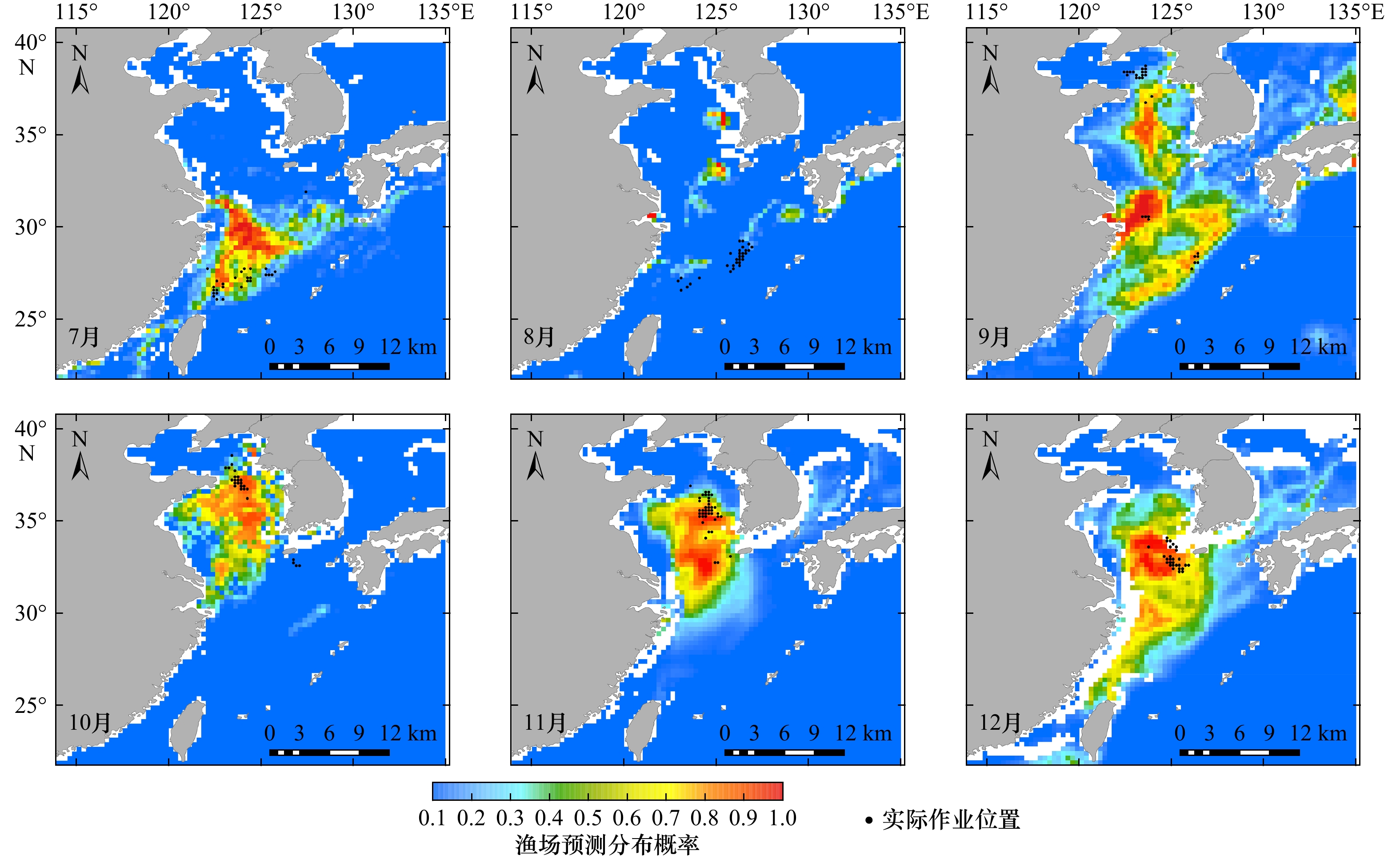
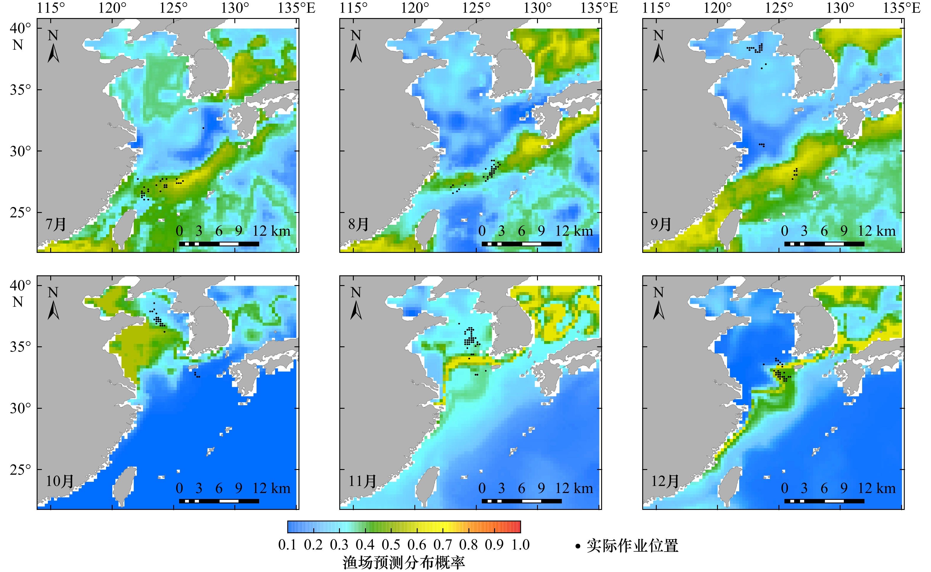
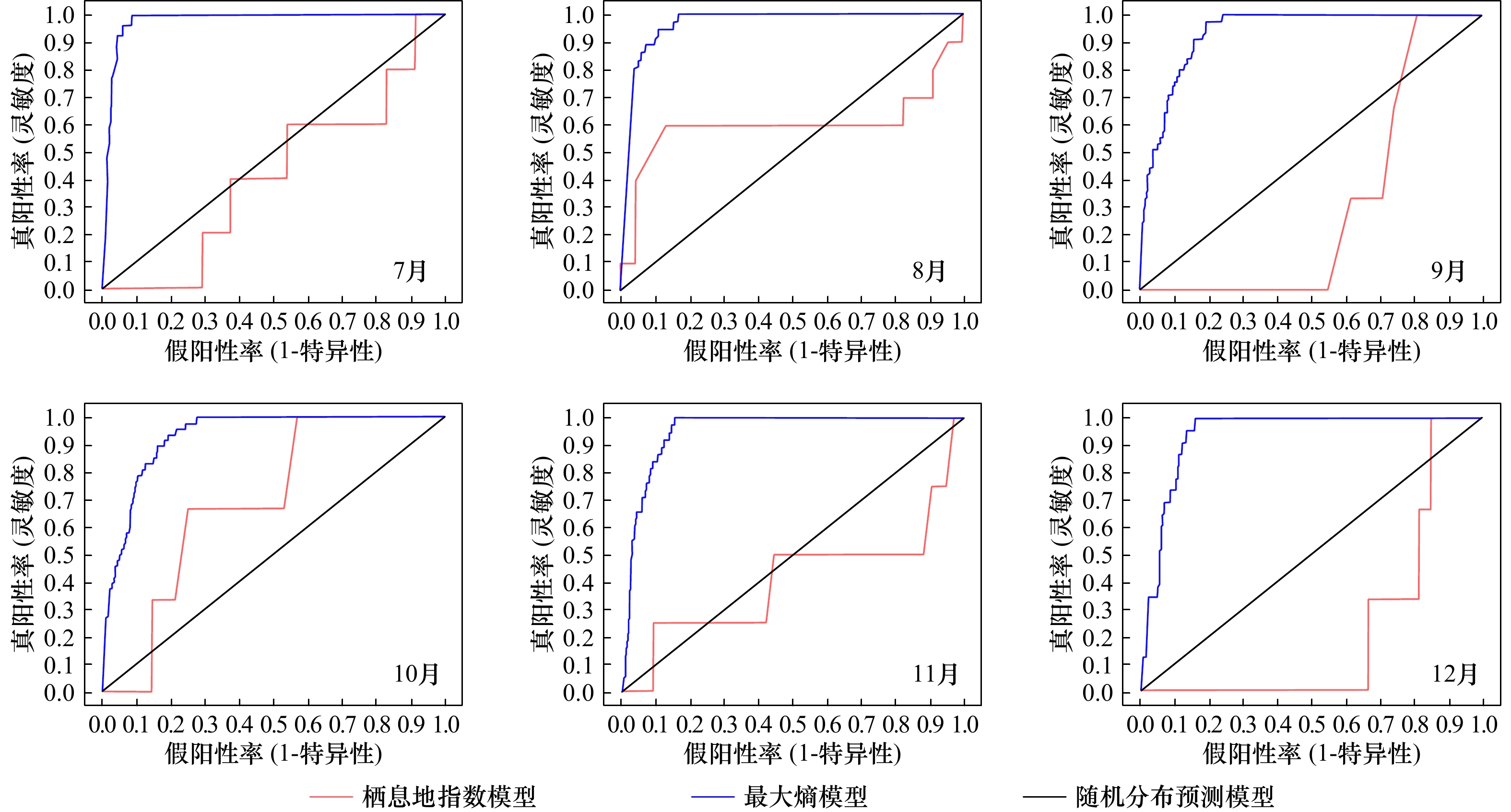
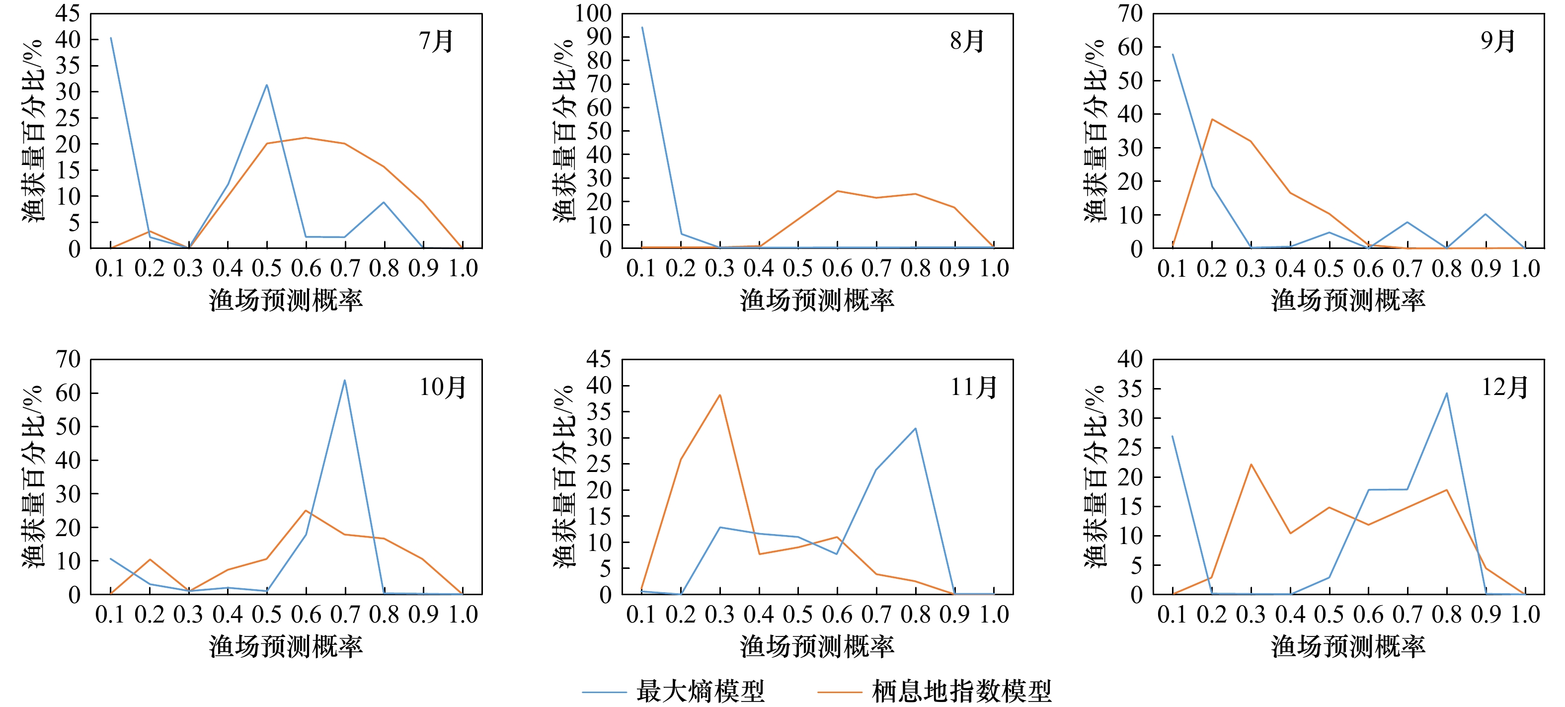
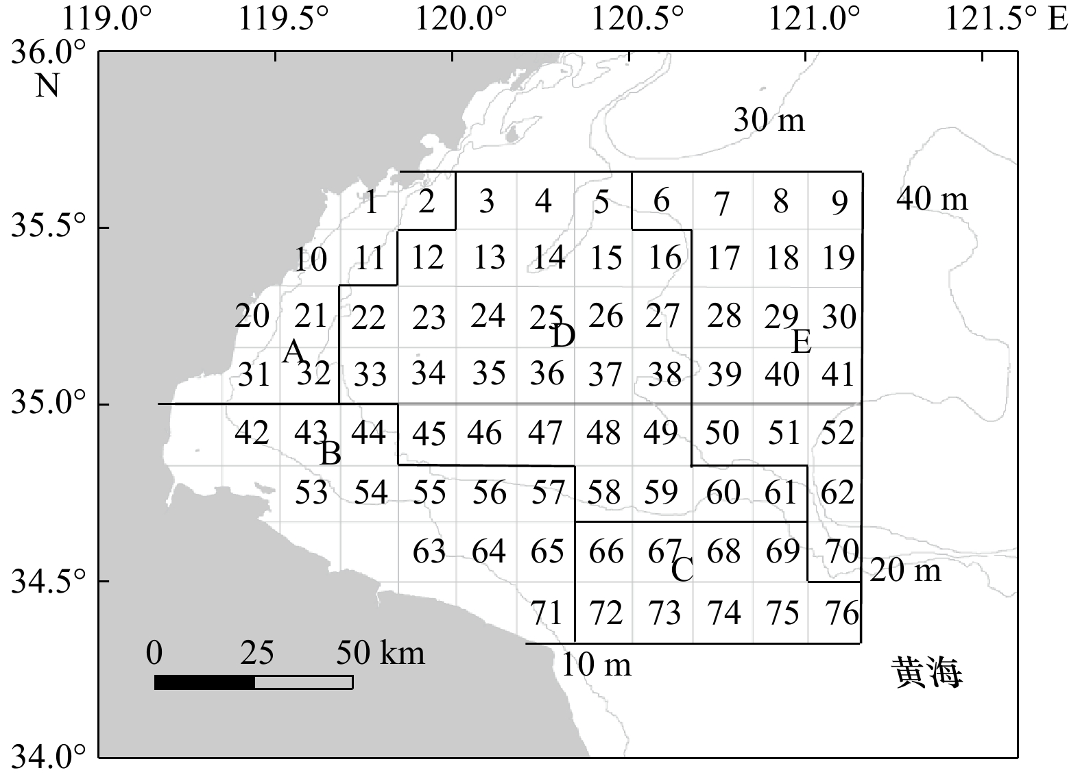
The maximum entropy model (Maxent) and habitat suitability index (HSI) model are widely used in fishery forecasting studies. To compare the forecasting performance of these two models on fishing grounds and improve the scientific management of chub mackerel (Scomber japonicus) resources, this study used the fishery data of chub mackerel in the East China Sea and Yellow Sea from 2003 to 2012, and marine environmental data, including sea surface temperature, sea surface height, sea surface salinity and sea surface temperature gradient, to construct the Maxent model and HSI model. The aim was to analyze and compare the effectiveness of these two models in predicting the habitat of chub mackerel in the East China Sea and Yellow Sea. The quantitative evaluation of the prediction performance of the two models was conducted using the area under curve (AUC) of the receiver operating characteristic (ROC), and the correspondence between the probability of fishing grounds predicted by the models and the percentage of the actual catches. The results showed that: (1) locations predicted by the maximum entropy model to have a high probability of fishing occurrence coincided with actual fishing locations. The probability of predicting fishery occurrence in the sea area without historical fishing data was lower. Locations predicted to have a high habitat index by the HSI model partially overlapped with actual fishing locations. A high habitat index was obtained in the sea area without historical fishing data. The probability of the HSI model predicting non-fishing grounds as fishing grounds was higher than that of the Maxent model; (2) the monthly average AUC values of the Maxent and HSI model were 0.95 and 0.66, respectively, indicating that the Maxent had relatively better predictive results; (3) when using the HSI model, non-fishing grounds data should be added to the model, and the collection of such data should be strengthened otherwise, there is a possibility of overestimation when such models forecast fishing grounds. When using the Maxent, the spatial coverage of fishery data must be improved otherwise, it cannot fully reflect the spatial and temporal distribution dynamics of the fishery. The results of this study provide a reference for improving the accuracy of forecasting for the chub mackerel fishery in the East China Sea and Yellow Sea.
The maximum entropy model (Maxent) and habitat suitability index (HSI) model are widely used in fishery forecasting studies. To compare the forecasting performance of these two models on fishing grounds and improve the scientific management of chub mackerel (Scomber japonicus) resources, this study used the fishery data of chub mackerel in the East China Sea and Yellow Sea from 2003 to 2012, and marine environmental data, including sea surface temperature, sea surface height, sea surface salinity and sea surface temperature gradient, to construct the Maxent model and HSI model. The aim was to analyze and compare the effectiveness of these two models in predicting the habitat of chub mackerel in the East China Sea and Yellow Sea. The quantitative evaluation of the prediction performance of the two models was conducted using the area under curve (AUC) of the receiver operating characteristic (ROC), and the correspondence between the probability of fishing grounds predicted by the models and the percentage of the actual catches. The results showed that: (1) locations predicted by the maximum entropy model to have a high probability of fishing occurrence coincided with actual fishing locations. The probability of predicting fishery occurrence in the sea area without historical fishing data was lower. Locations predicted to have a high habitat index by the HSI model partially overlapped with actual fishing locations. A high habitat index was obtained in the sea area without historical fishing data. The probability of the HSI model predicting non-fishing grounds as fishing grounds was higher than that of the Maxent model; (2) the monthly average AUC values of the Maxent and HSI model were 0.95 and 0.66, respectively, indicating that the Maxent had relatively better predictive results; (3) when using the HSI model, non-fishing grounds data should be added to the model, and the collection of such data should be strengthened otherwise, there is a possibility of overestimation when such models forecast fishing grounds. When using the Maxent, the spatial coverage of fishery data must be improved otherwise, it cannot fully reflect the spatial and temporal distribution dynamics of the fishery. The results of this study provide a reference for improving the accuracy of forecasting for the chub mackerel fishery in the East China Sea and Yellow Sea.
2023, 45(9): 82-90.
doi: 10.12284/hyxb2023134
Abstract:
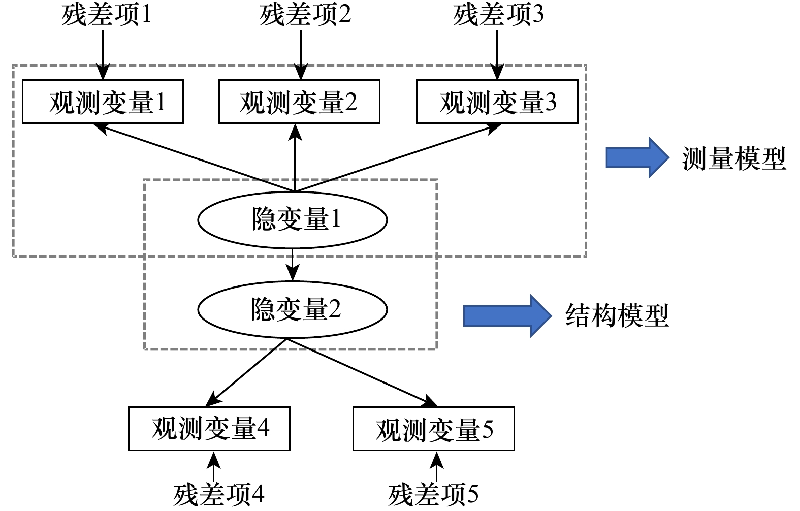
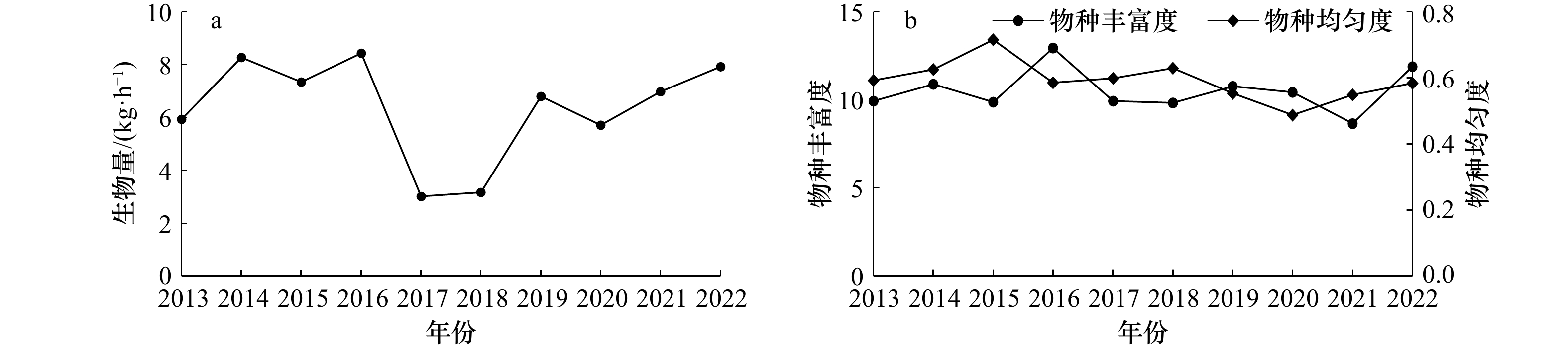
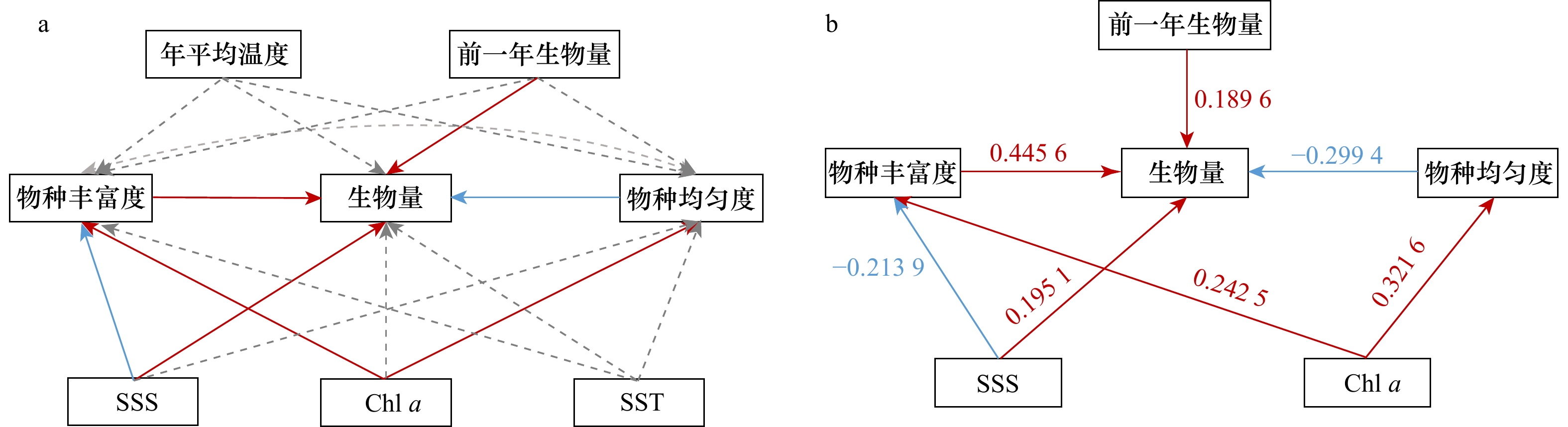
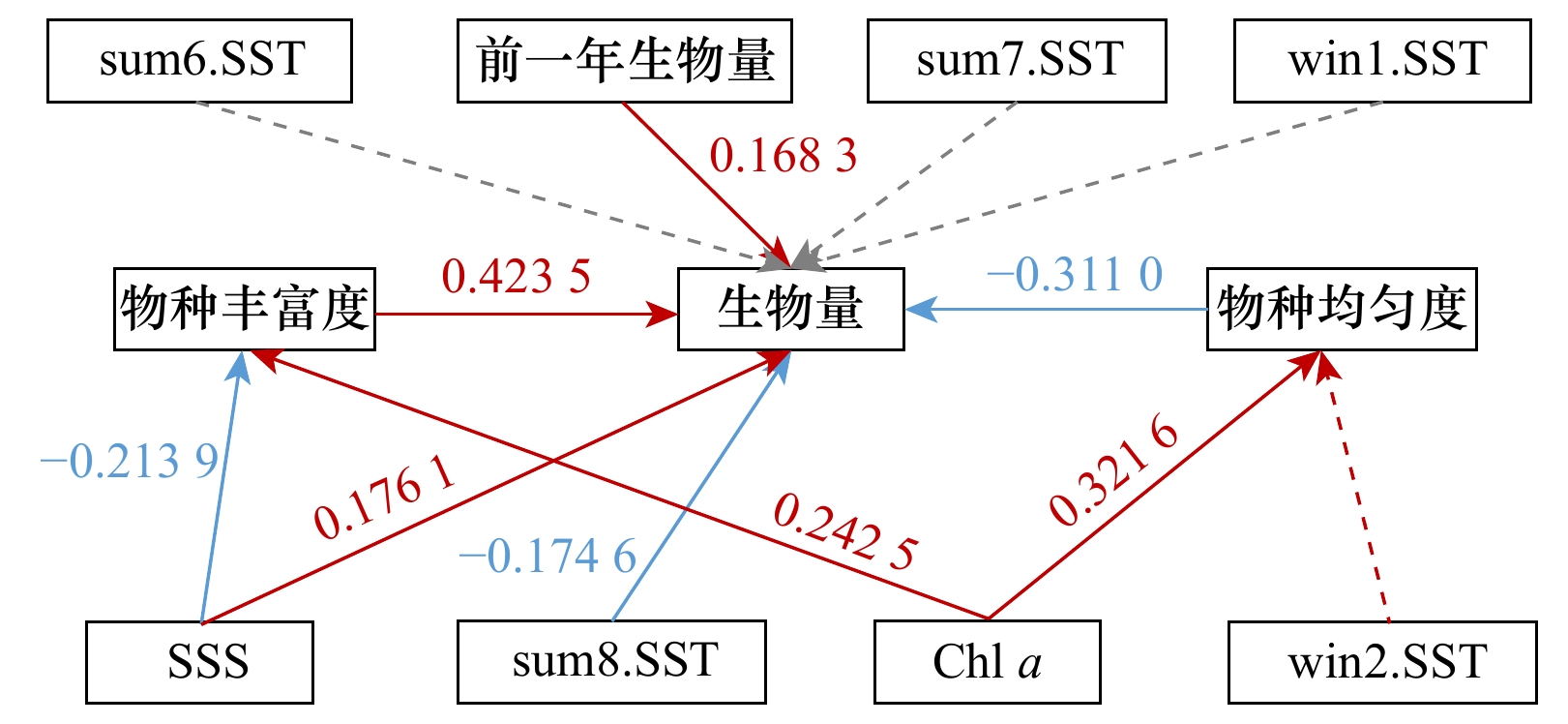
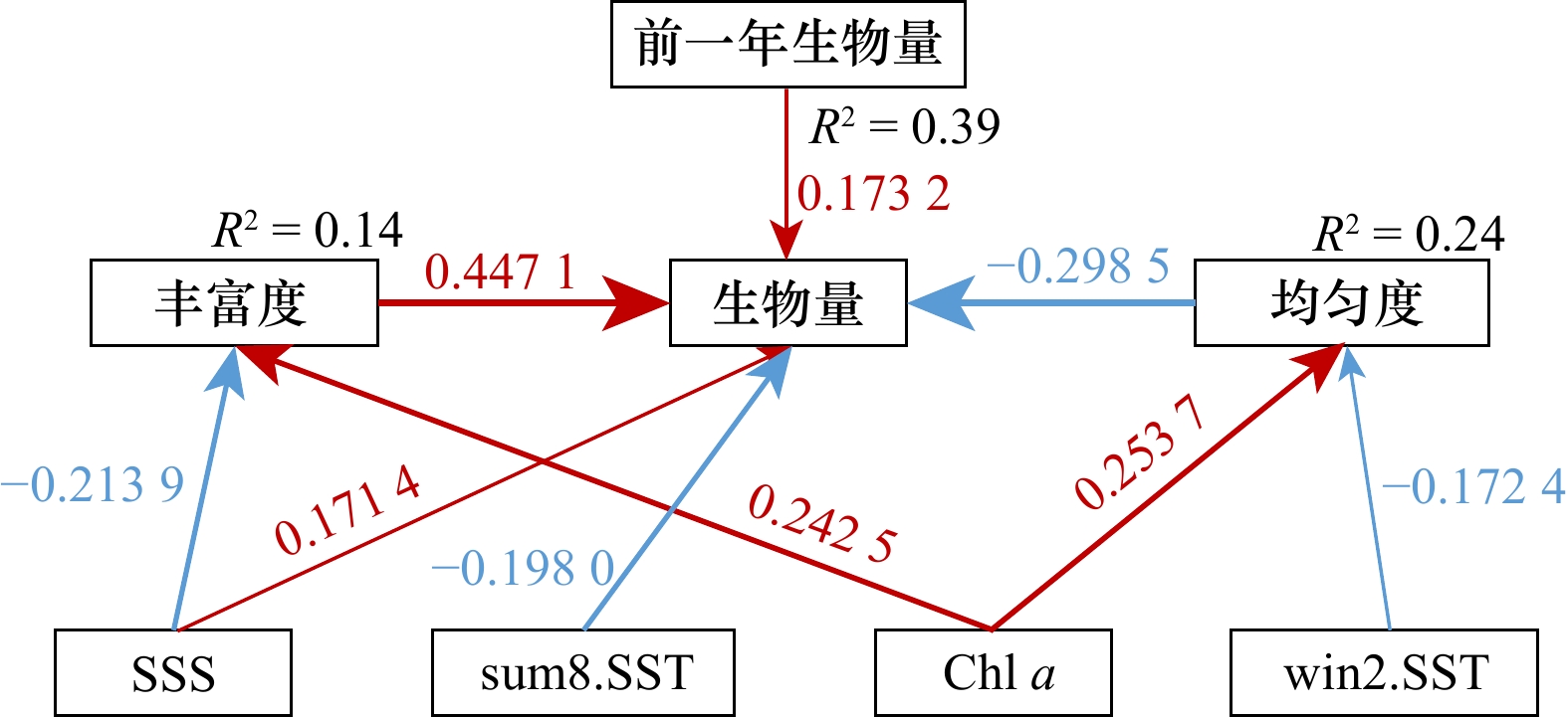
Many of the global ecosystem functions are changing with the loss of biodiversity. It is therefore particularly important to understand the biodiversity-ecosystem functioning (BEF) relationships to support scientific ecological conservation and management. In this study, we evaluated the relationship between environmental factors, biodiversity (species richness and evenness) and ecosystem functions (measured as total biomass) in the benthic fish community of Haizhou Bay, using structural equation modeling (SEM) based on bottom trawl survey data conducted in spring 2013−2022. The results showed that there was a significant positive correlation between species richness and biomass, and a significant negative correlation between evenness and biomass. Among the environmental factors, salinity had significant effects on both species richness and biomass. Regarding the effects of temperature, the temperatures in winter and summer had a stronger effect on biomass than that of annual average temperature. The study suggested that two mechanisms, the niche complementarity mechanism and selection mechanism, may simultaneously play a role in maintaining the biodiversity-biomass relationships in the groundfish communities of Haizhou Bay, and in addition to the fact that such relationships depend on the environmental and habitat conditions.
Many of the global ecosystem functions are changing with the loss of biodiversity. It is therefore particularly important to understand the biodiversity-ecosystem functioning (BEF) relationships to support scientific ecological conservation and management. In this study, we evaluated the relationship between environmental factors, biodiversity (species richness and evenness) and ecosystem functions (measured as total biomass) in the benthic fish community of Haizhou Bay, using structural equation modeling (SEM) based on bottom trawl survey data conducted in spring 2013−2022. The results showed that there was a significant positive correlation between species richness and biomass, and a significant negative correlation between evenness and biomass. Among the environmental factors, salinity had significant effects on both species richness and biomass. Regarding the effects of temperature, the temperatures in winter and summer had a stronger effect on biomass than that of annual average temperature. The study suggested that two mechanisms, the niche complementarity mechanism and selection mechanism, may simultaneously play a role in maintaining the biodiversity-biomass relationships in the groundfish communities of Haizhou Bay, and in addition to the fact that such relationships depend on the environmental and habitat conditions.
2023, 45(9): 91-104.
doi: 10.12284/hyxb2023128
Abstract:
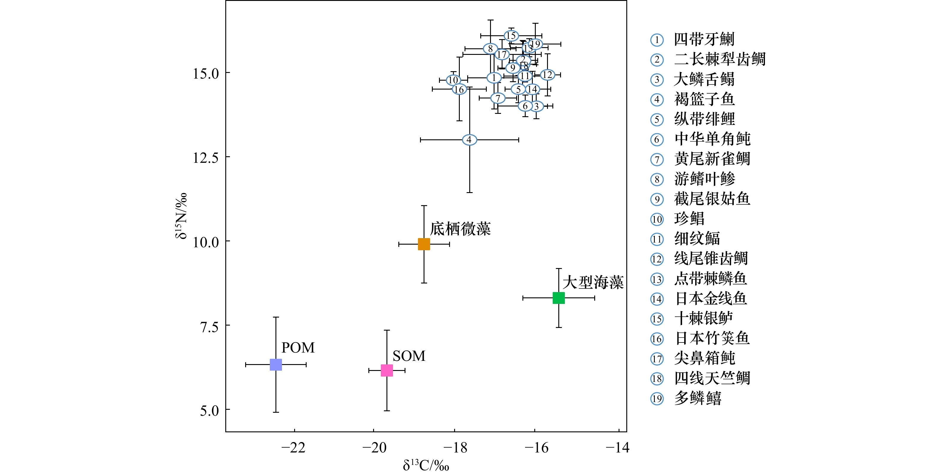
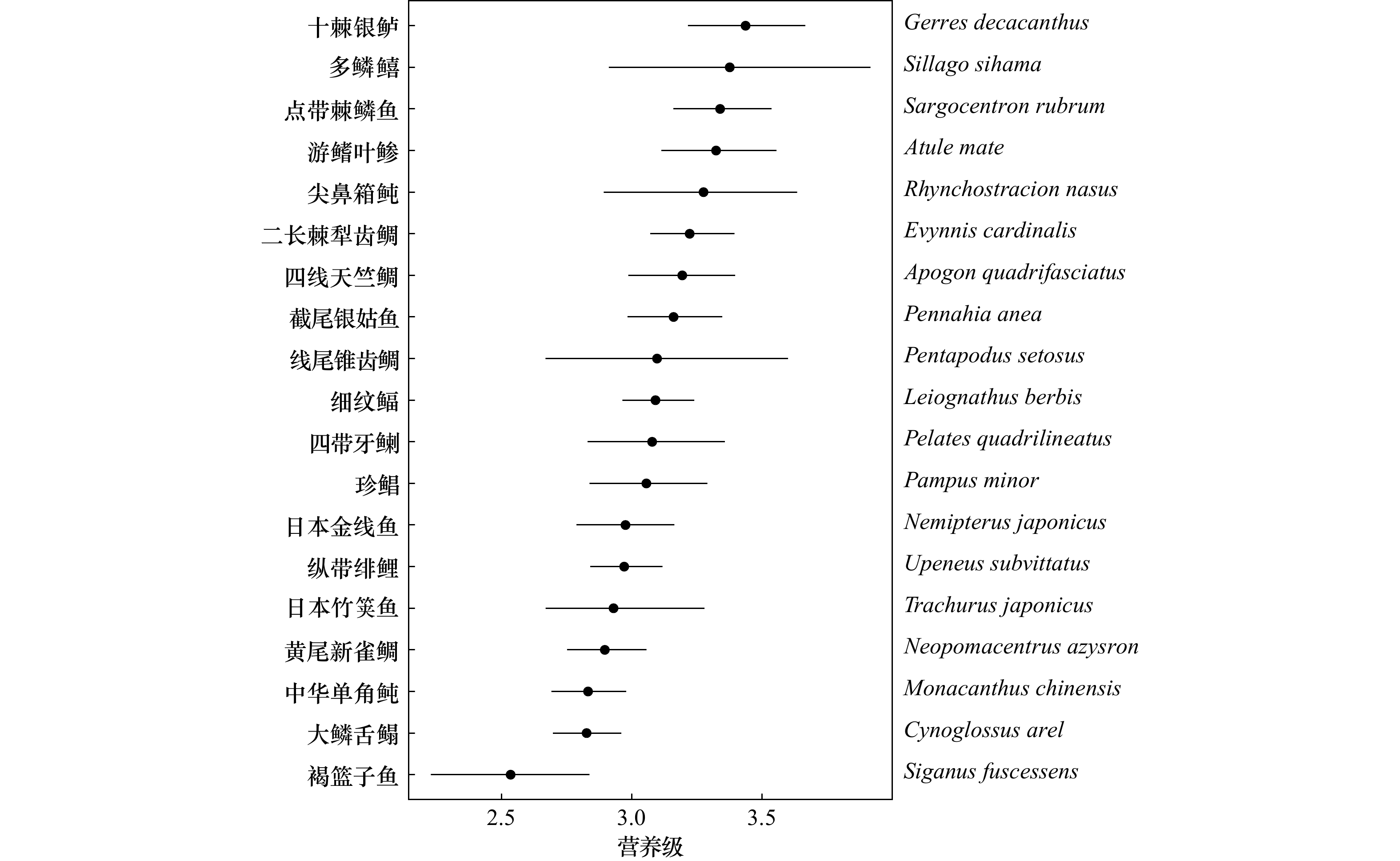
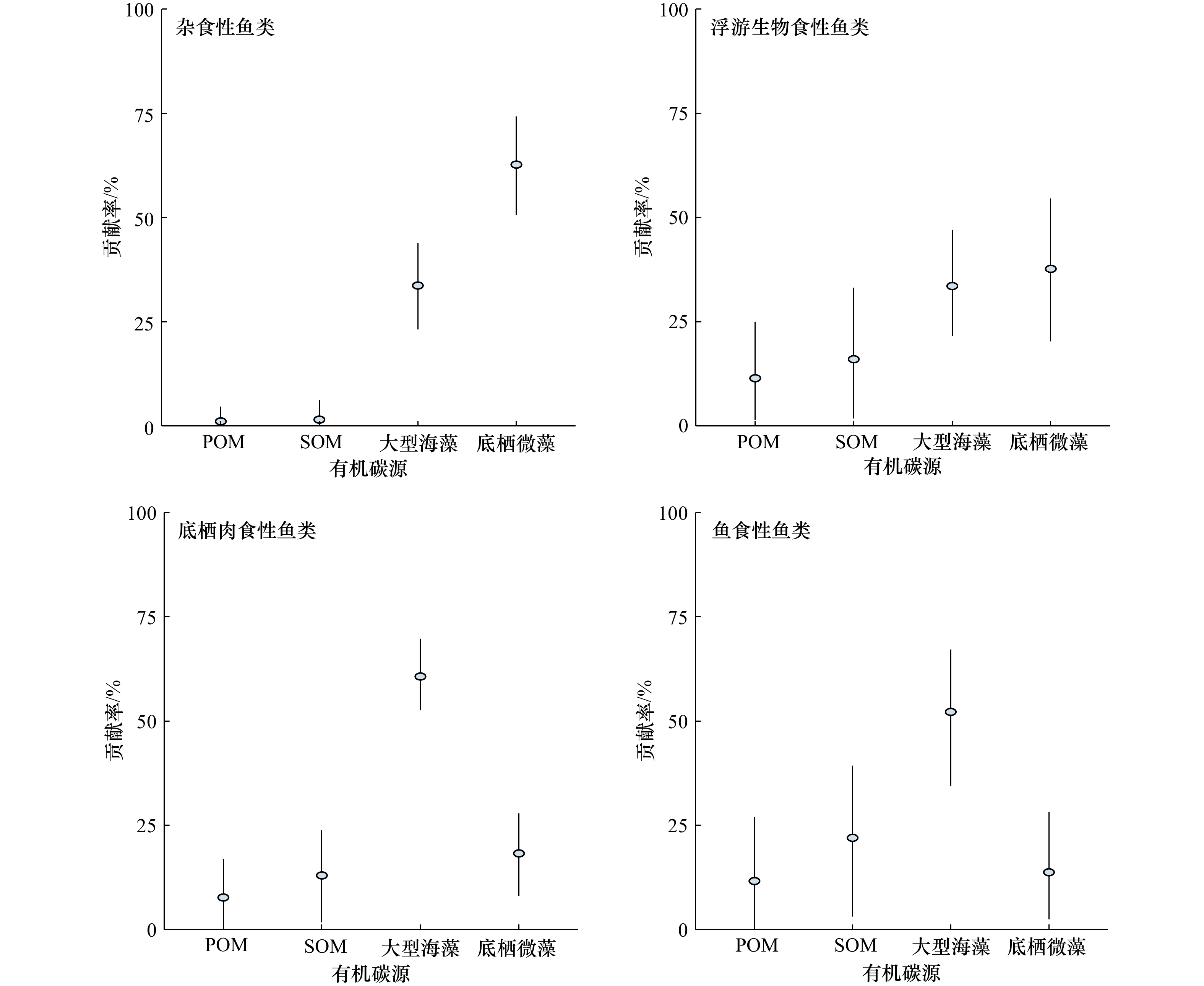
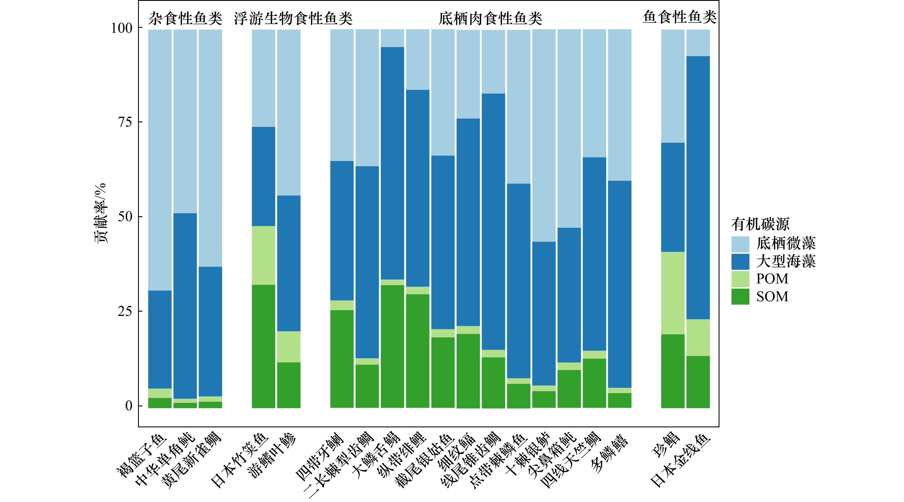
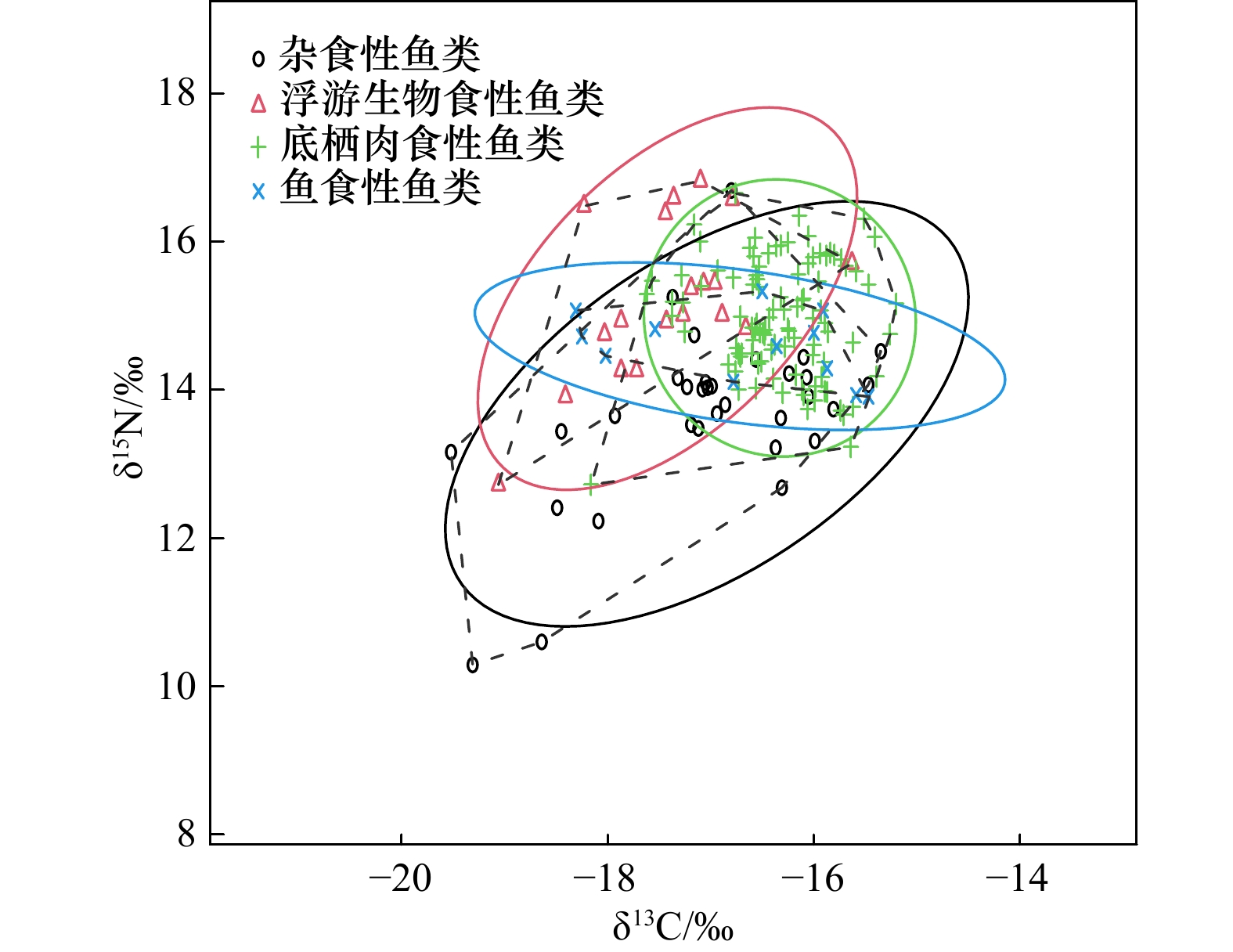
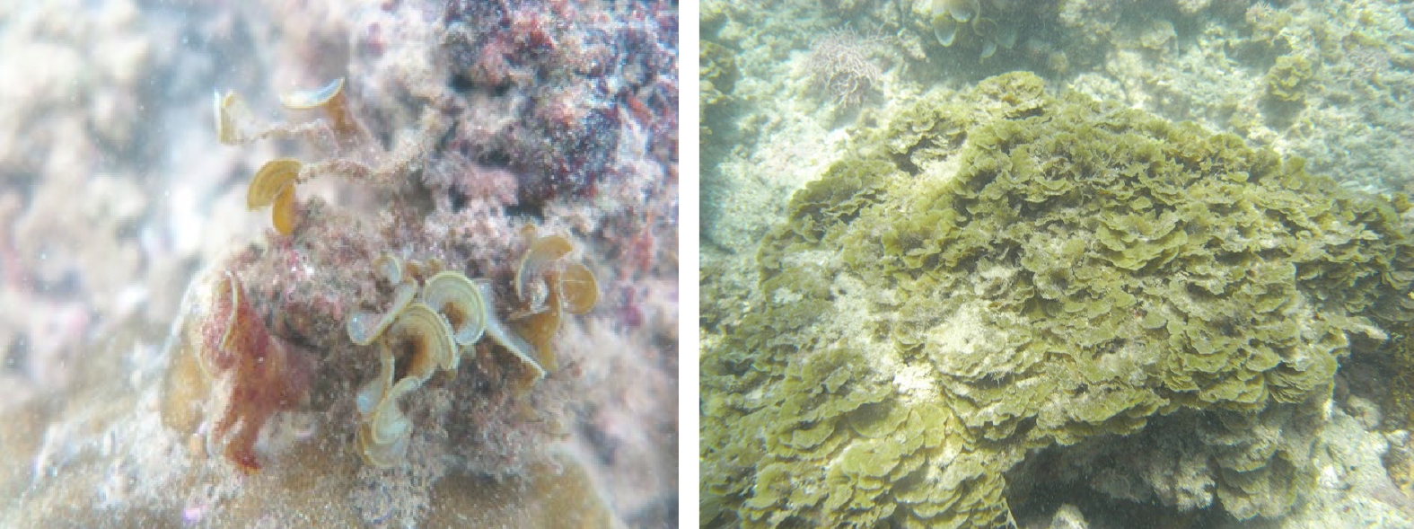
Here, stable carbon and nitrogen isotope (δ13C and δ15N) techniques are used to estimate the trophic levels (TL) and main carbon sources of the dominant fish in the coral reefs of Weizhou Island in autumn. Combined with the six quantitative indicators of community trophic structure, the trophic relationship of the dominant fish in the coral reefs of Weizhou Island in autumn is preliminarily analyzed. The results show that the δ13C and δ15N values of different fishes are significantly different (p < 0.01). The δ13C values are between −18.3‰ and −15.4‰, and the δ15N values are between 12.9‰ and 16.3‰. The trophic levels of fish ranged from 2.5 to 3.4, with an average values of 3.0 ± 0.8, indicating that fish in Weizhou Island are mainly carnivorous. The organic carbon sources of fish in Weizhou Island are complex, but macroalgae and benthic microalgae are the key carbon sources fuelling fish food webs. The food source diversity level and trophic level length (CR and NR) of fish community are 2.35 and 3.09, respectively. The total area (TA), mean centrifugal distance (CD), mean nearest neighbor distance (MNND) and standard deviation of nearest neighbor distance (SDNND) are 4.48, 0.89, 0.40 and 0.29, respectively. These above indicators suggest that the trophic structure of coral reef fish community in Weizhou Island has a high degree of nutritional redundancy, but the food chain is short and the nutritional diversity is low. The coral reef ecosystem in Weizhou Island is incomplete in food web structure. In the future, it is necessary to carry out appropriate control and restoration measures to restore the structure and function of the coral reef ecosystem in Weizhou Island.
Here, stable carbon and nitrogen isotope (δ13C and δ15N) techniques are used to estimate the trophic levels (TL) and main carbon sources of the dominant fish in the coral reefs of Weizhou Island in autumn. Combined with the six quantitative indicators of community trophic structure, the trophic relationship of the dominant fish in the coral reefs of Weizhou Island in autumn is preliminarily analyzed. The results show that the δ13C and δ15N values of different fishes are significantly different (p < 0.01). The δ13C values are between −18.3‰ and −15.4‰, and the δ15N values are between 12.9‰ and 16.3‰. The trophic levels of fish ranged from 2.5 to 3.4, with an average values of 3.0 ± 0.8, indicating that fish in Weizhou Island are mainly carnivorous. The organic carbon sources of fish in Weizhou Island are complex, but macroalgae and benthic microalgae are the key carbon sources fuelling fish food webs. The food source diversity level and trophic level length (CR and NR) of fish community are 2.35 and 3.09, respectively. The total area (TA), mean centrifugal distance (CD), mean nearest neighbor distance (MNND) and standard deviation of nearest neighbor distance (SDNND) are 4.48, 0.89, 0.40 and 0.29, respectively. These above indicators suggest that the trophic structure of coral reef fish community in Weizhou Island has a high degree of nutritional redundancy, but the food chain is short and the nutritional diversity is low. The coral reef ecosystem in Weizhou Island is incomplete in food web structure. In the future, it is necessary to carry out appropriate control and restoration measures to restore the structure and function of the coral reef ecosystem in Weizhou Island.
2023, 45(9): 105-118.
doi: 10.12284/hyxb2023120
Abstract:
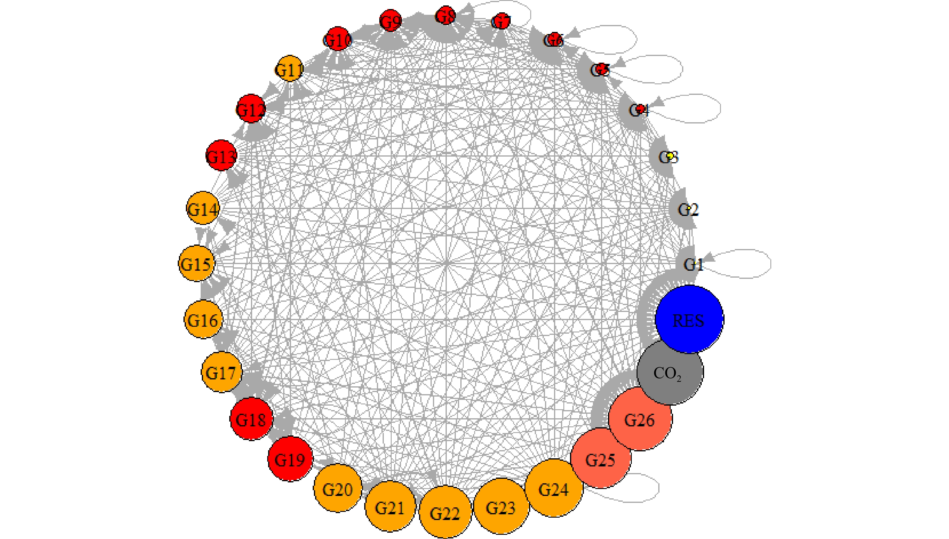
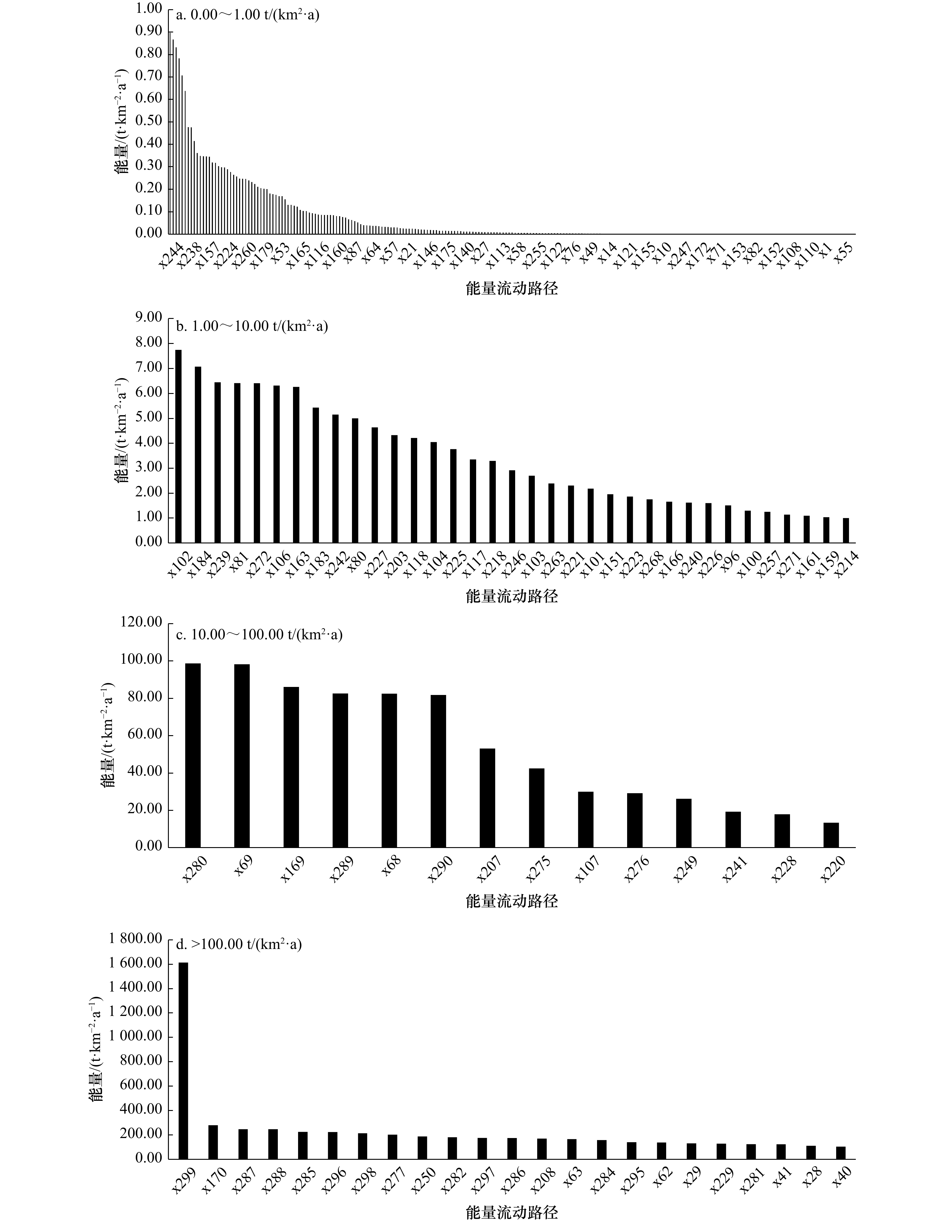
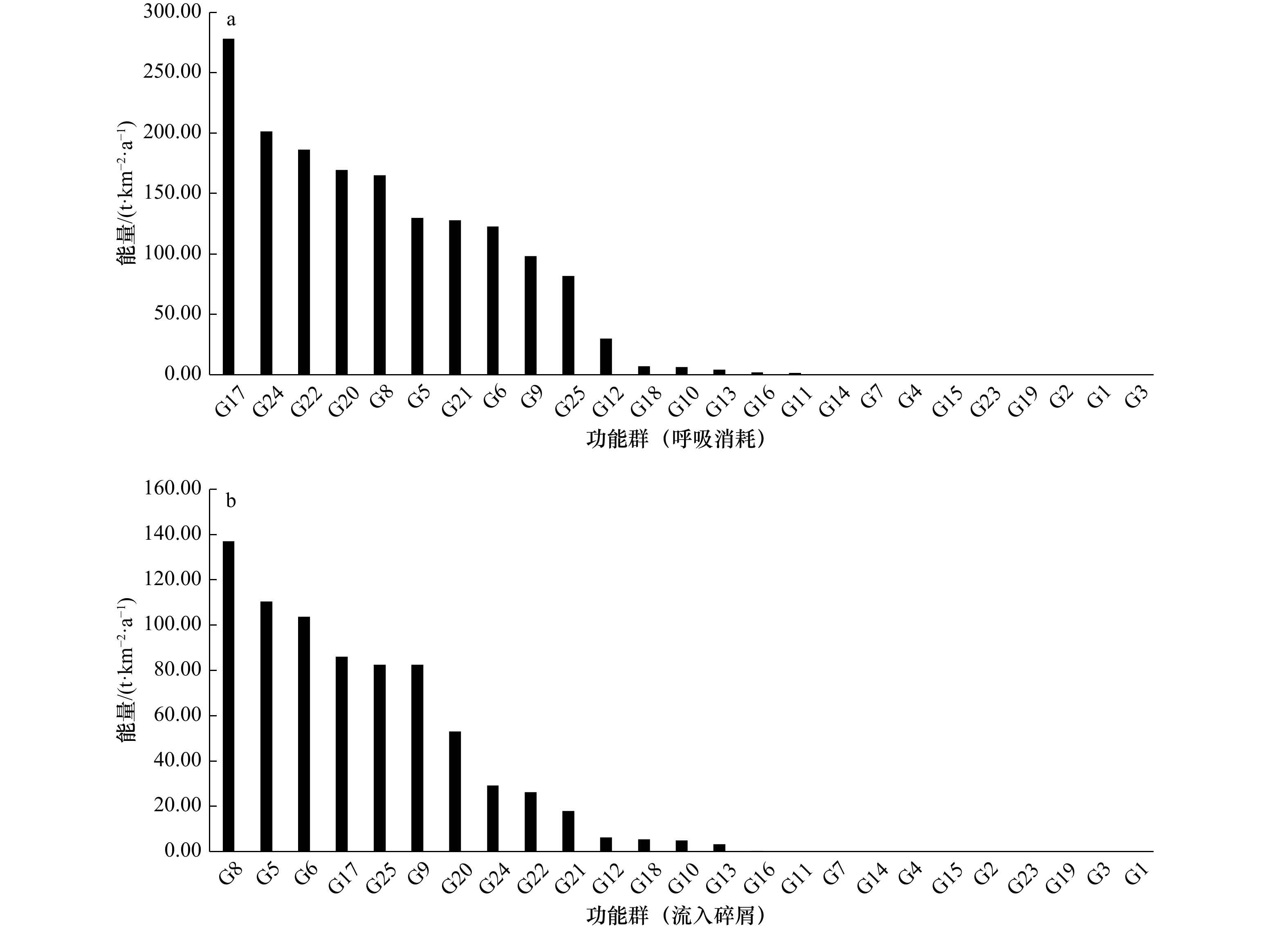
Study on the structure and energy flow of food webs is important for maintaining the stability of structure and function of marine ecosystems, which will contribute to the in-depth understanding of the complex processes of marine ecosystems. Based on the seasonal bottom trawl survey data in the northern waters of Jiangsu Province from 2019−2021, a linear inverse models using a Monte Carlo method coupled with Markov chain model combined with ecological network analysis (ENA) were used to explore the status of the ecosystem and energy flow characteristics of the food web in this area. The results showed that there were 299 energy flow paths in the ecosystem, which showed a typical pyramid structure. In addition, the energy consumed by respiration and the energy flowing into the detritus of each functional group remains synchronized. Compared with other sea areas, connectance (C) and system omnivory index (SOI) were 0.40 and 0.22, respectively, which were at relatively high levels, indicating that organisms from different trophic levels in this ecosystem were closely connected. It has a relatively complex food web structure, which can resist external disturbance. Total primary production/total respiration (TPP/TR) and Finn’s cycling index (FCI) were 1.05 and 5.76%, respectively, indicating that the ecosystem was relatively mature and used energy efficiently. In addition, constraint efficiency (CE), extent of development (AC), synergism index (b/c) and dominance indirect effects (i/d) also indicated high potential for development and regeneration. This study will provide a theoretical basis for the restoration and sustainable utilization of fishery resources in the northern waters of Jiangsu Povince, and provide a scientific basis for the implementation of Ecosystem-based fishery management in this area.
Study on the structure and energy flow of food webs is important for maintaining the stability of structure and function of marine ecosystems, which will contribute to the in-depth understanding of the complex processes of marine ecosystems. Based on the seasonal bottom trawl survey data in the northern waters of Jiangsu Province from 2019−2021, a linear inverse models using a Monte Carlo method coupled with Markov chain model combined with ecological network analysis (ENA) were used to explore the status of the ecosystem and energy flow characteristics of the food web in this area. The results showed that there were 299 energy flow paths in the ecosystem, which showed a typical pyramid structure. In addition, the energy consumed by respiration and the energy flowing into the detritus of each functional group remains synchronized. Compared with other sea areas, connectance (C) and system omnivory index (SOI) were 0.40 and 0.22, respectively, which were at relatively high levels, indicating that organisms from different trophic levels in this ecosystem were closely connected. It has a relatively complex food web structure, which can resist external disturbance. Total primary production/total respiration (TPP/TR) and Finn’s cycling index (FCI) were 1.05 and 5.76%, respectively, indicating that the ecosystem was relatively mature and used energy efficiently. In addition, constraint efficiency (CE), extent of development (AC), synergism index (b/c) and dominance indirect effects (i/d) also indicated high potential for development and regeneration. This study will provide a theoretical basis for the restoration and sustainable utilization of fishery resources in the northern waters of Jiangsu Povince, and provide a scientific basis for the implementation of Ecosystem-based fishery management in this area.

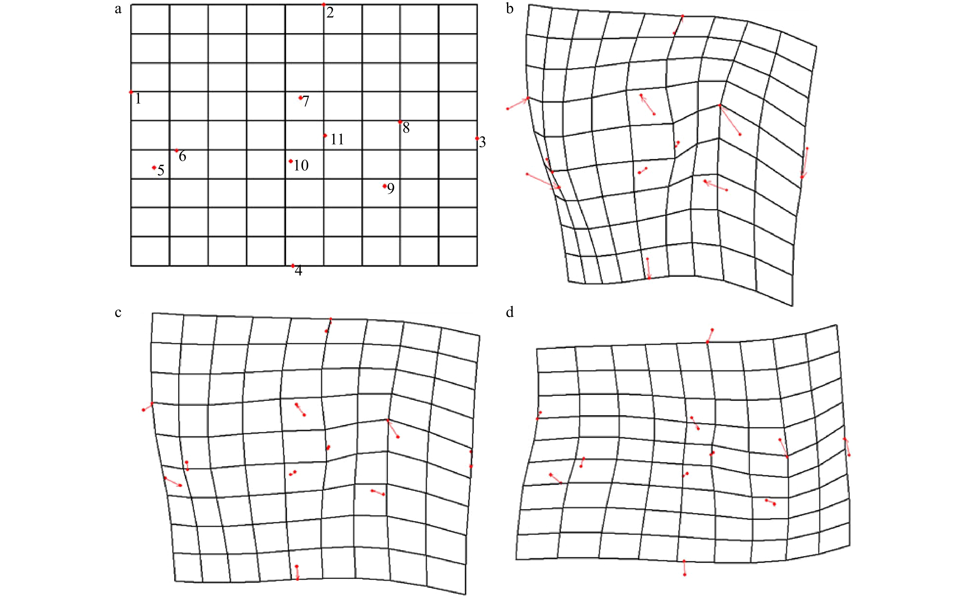
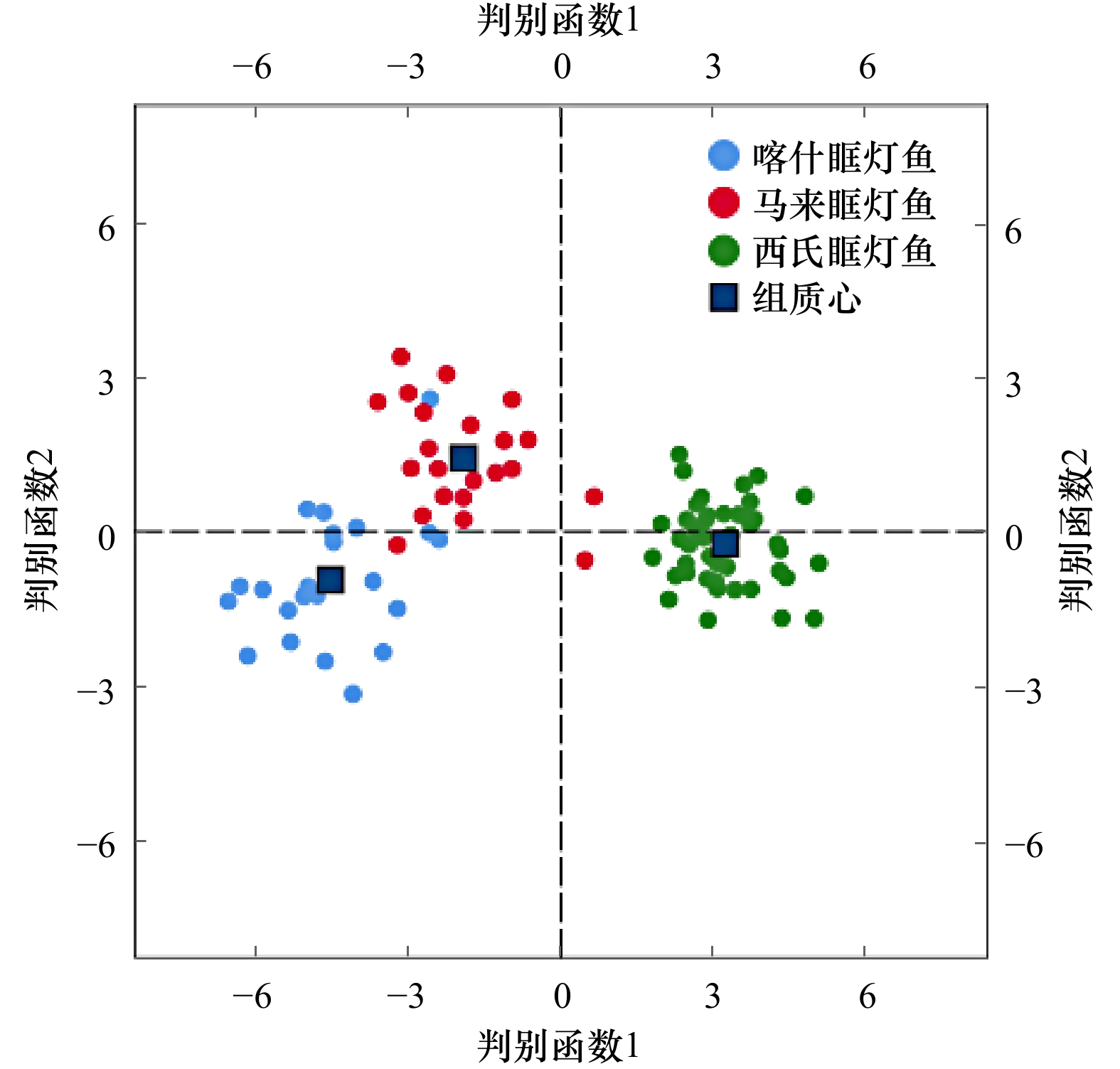
Interspecies differences in the otolith morphology of three Diaphus species based on landmark method
2023, 45(9): 119-127.
doi: 10.12284/hyxb2023132
Abstract:
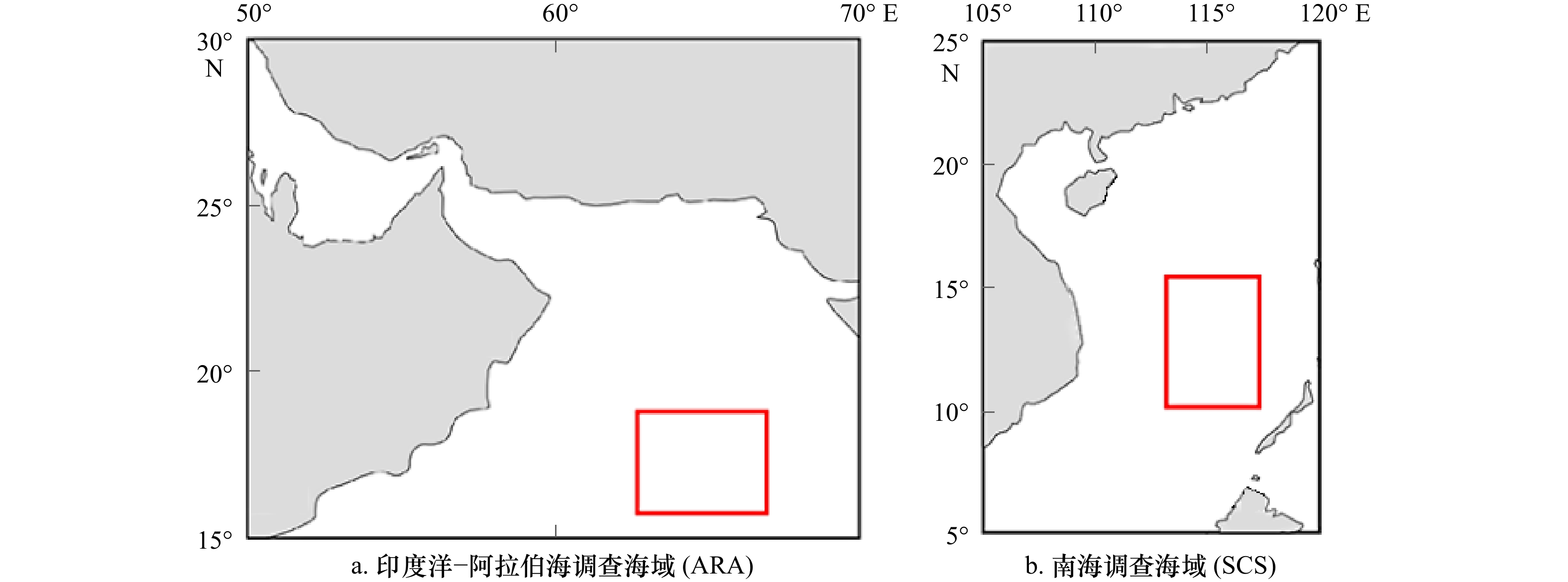
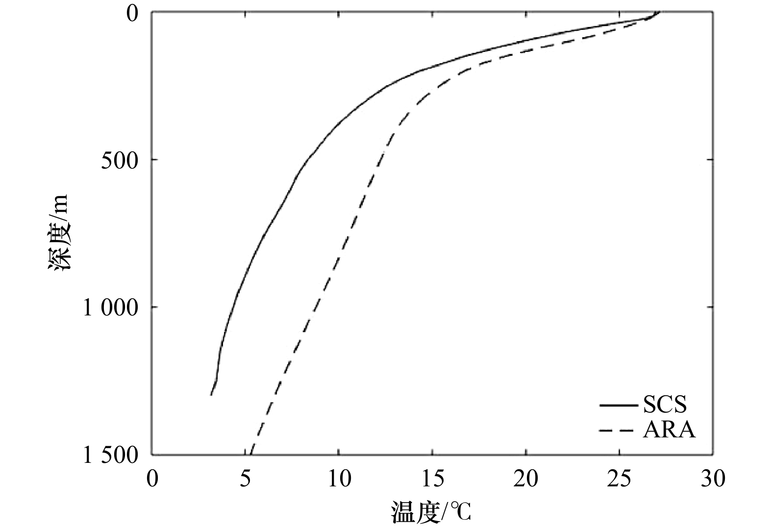
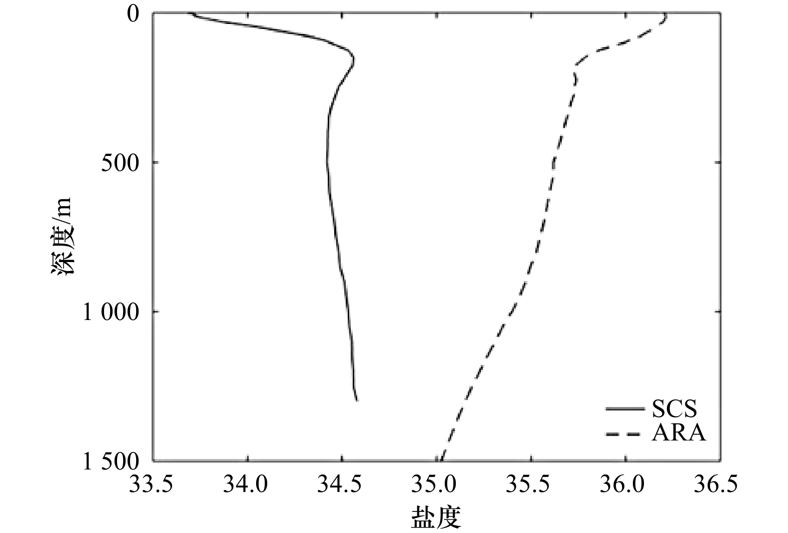
Diaphus is one of the genera with the highest species abundance and the most abundant population in the family Myctophidae, and it is also the dominant group of deep sea fishes in the ocean. However, due to the high similarity of external morphology, it is difficult to identify the lanternfish species. In order to explore the feasibility of otoliths morphological analysis in identifying the otolith differences between Diaphus species with similar otoliths and large overlapping distribution areas, the otoliths of three Diaphus species were collected from the Indian Ocean and the South China Sea for morphometrics analysis with landmark method. The results showed that the morphological variation of sagittal otoliths in three lanternfishes were mainly in the internal main sulcus, and the internal punctuation contribution rate reached 62%. The grid difference visualization showed that the wing length of sagittal otoliths in D. thiollierei was longer than that of the other two species, while the width was slightly narrower. The Bayes function was used for classification and discrimination, and the results showed that the success rate of D. thiollierei was 100%, while the other two species had a few misjudgments. In addition, taking into account the habitat environment and the genetic relationship between these three species, we supposed that the main reason for the morphological differences in the main sulcus of the three spescies was the huge salinity difference in the habitat sea area. However, the impact and physiological mechanism of salinity on the morphology of the main sulcus of sagittal otoliths needs to be further studied.
Diaphus is one of the genera with the highest species abundance and the most abundant population in the family Myctophidae, and it is also the dominant group of deep sea fishes in the ocean. However, due to the high similarity of external morphology, it is difficult to identify the lanternfish species. In order to explore the feasibility of otoliths morphological analysis in identifying the otolith differences between Diaphus species with similar otoliths and large overlapping distribution areas, the otoliths of three Diaphus species were collected from the Indian Ocean and the South China Sea for morphometrics analysis with landmark method. The results showed that the morphological variation of sagittal otoliths in three lanternfishes were mainly in the internal main sulcus, and the internal punctuation contribution rate reached 62%. The grid difference visualization showed that the wing length of sagittal otoliths in D. thiollierei was longer than that of the other two species, while the width was slightly narrower. The Bayes function was used for classification and discrimination, and the results showed that the success rate of D. thiollierei was 100%, while the other two species had a few misjudgments. In addition, taking into account the habitat environment and the genetic relationship between these three species, we supposed that the main reason for the morphological differences in the main sulcus of the three spescies was the huge salinity difference in the habitat sea area. However, the impact and physiological mechanism of salinity on the morphology of the main sulcus of sagittal otoliths needs to be further studied.

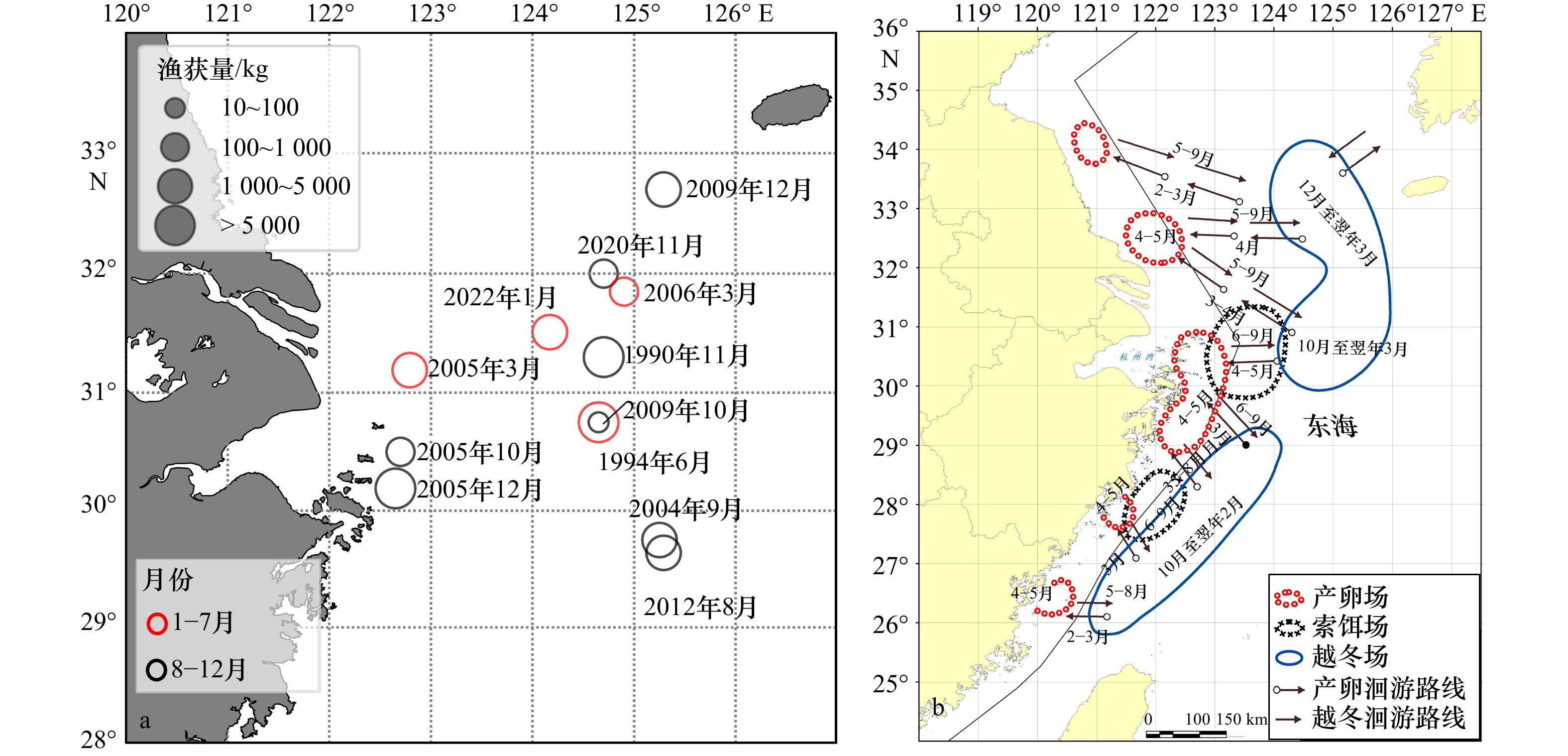
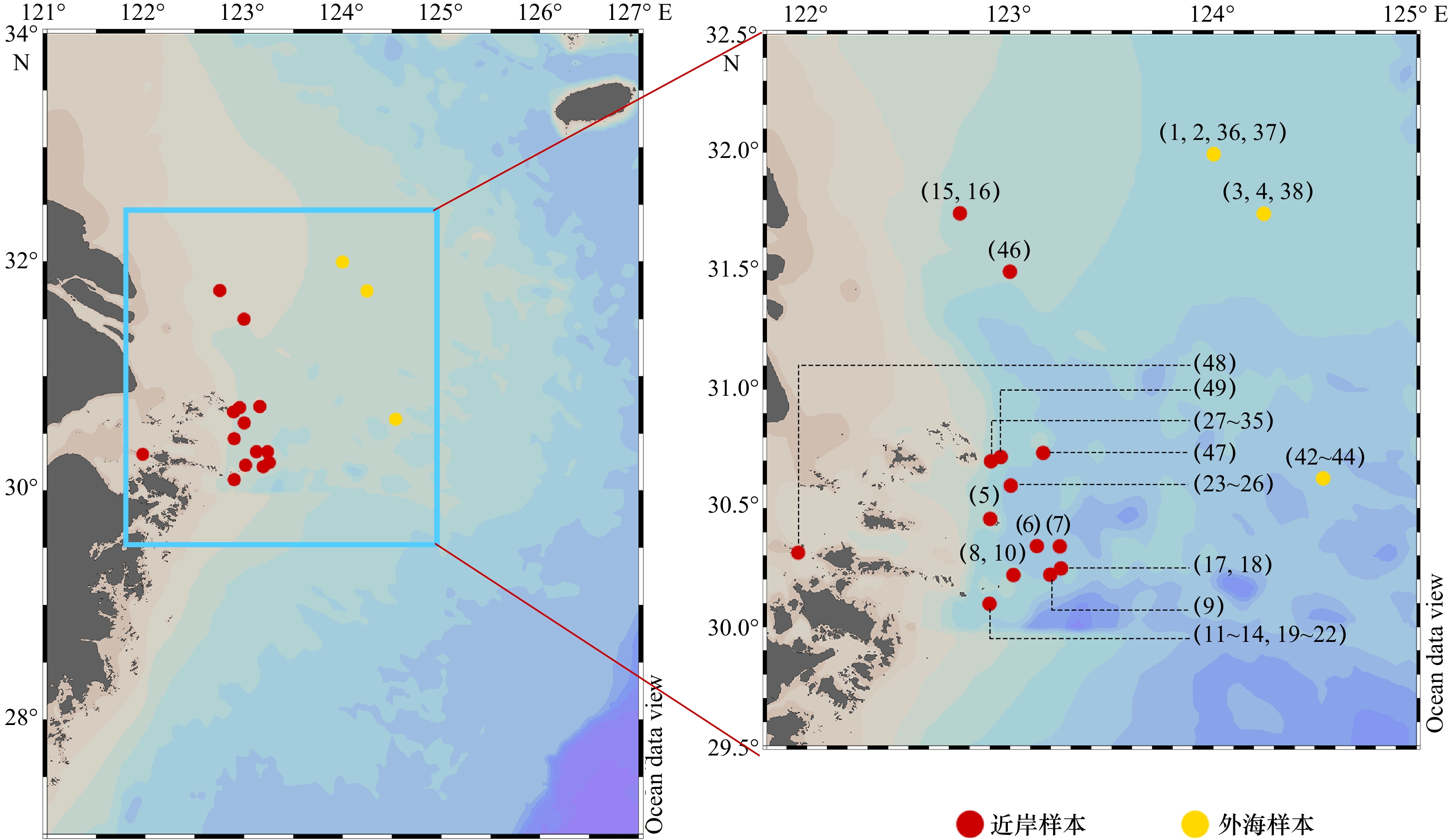
2023, 45(9): 128-140.
doi: 10.12284/hyxb2023126
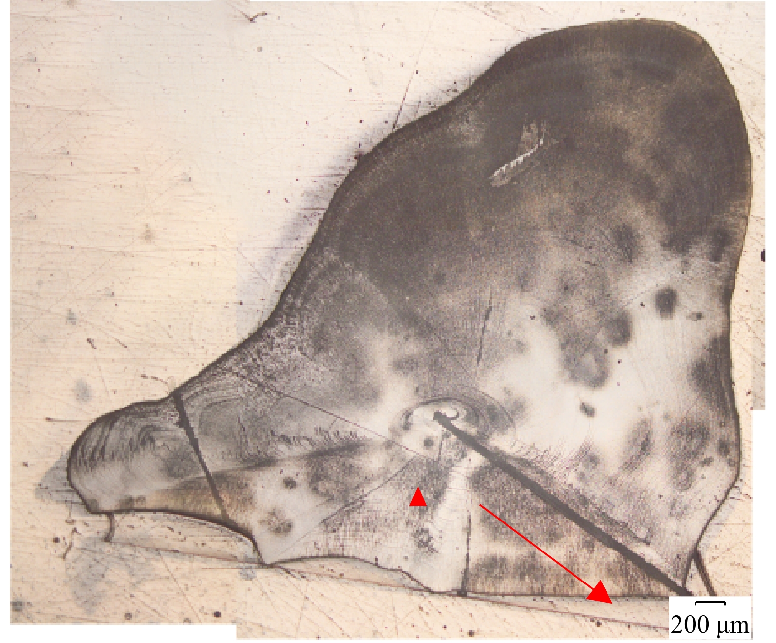
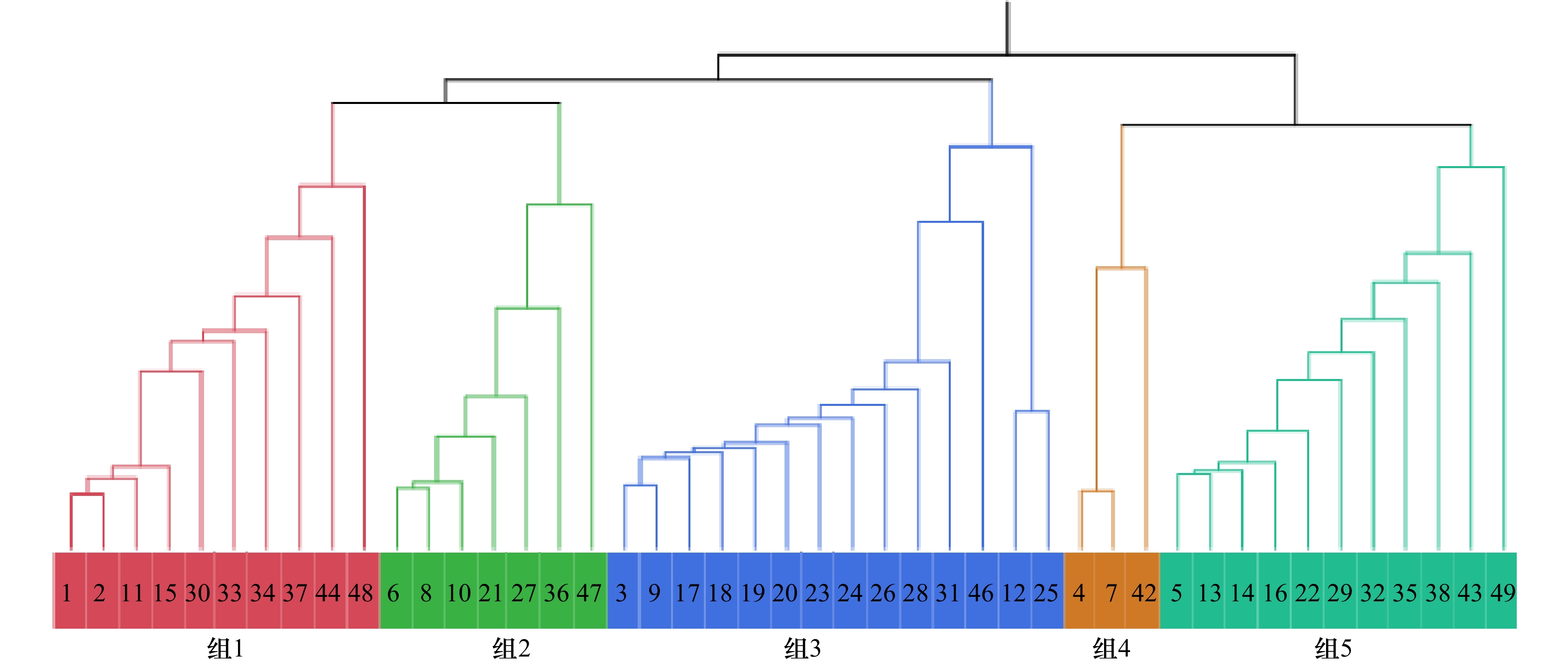
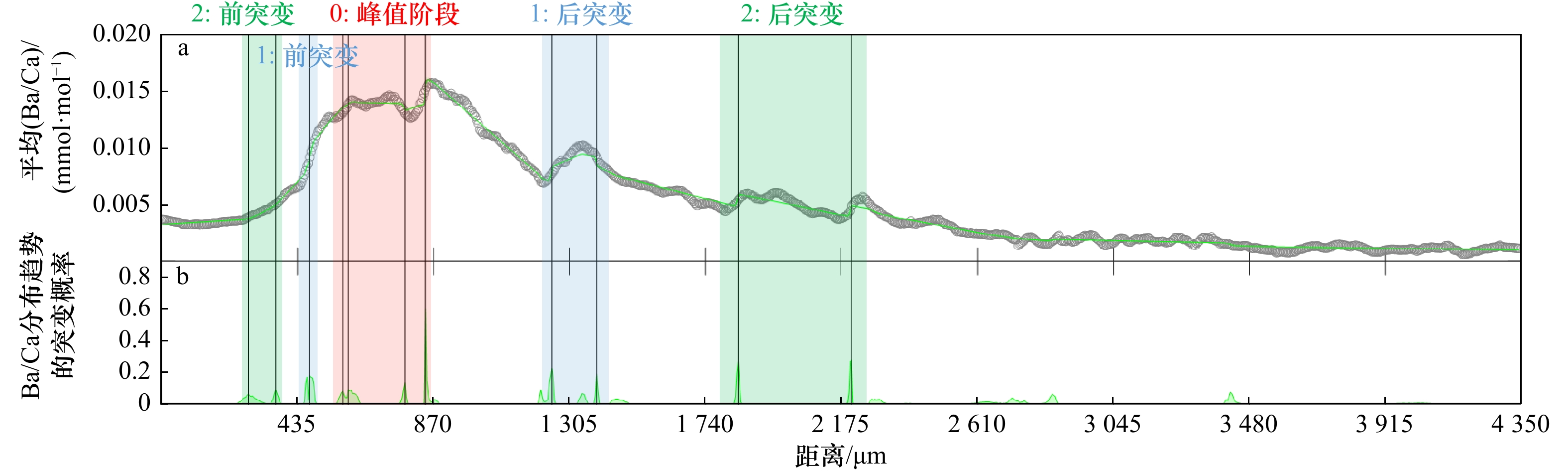
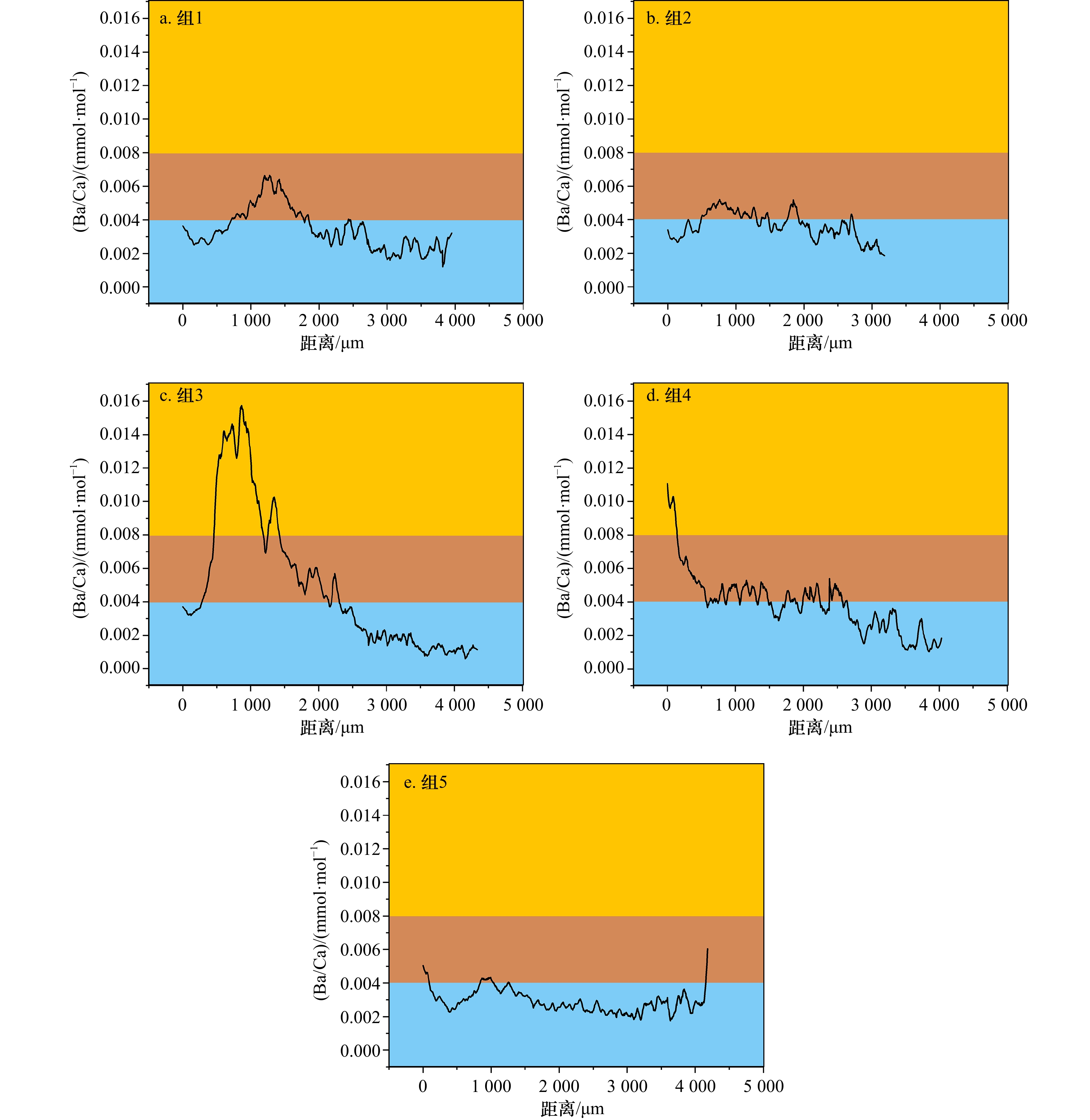
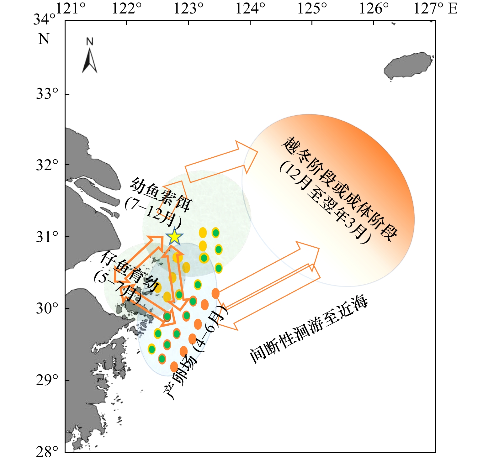
Abstract:
In recent years, large yellow croaker (LYC) has been caught with high abundance in the East China Sea (ECS), which raises concerns about the conservation of LYC resources. We collected LYC samples from spawning grounds and wintering grounds in the offshore Zhejiang from 2020 to 2022. In order to find out the migration route of LYC in the ECS, we made use of otolith microchemical elements by LA-ICP-MS analysis, combined with the clustering analysis and PCA of trace elements such as Ba/Ca, to classify different LYC groups. With the age characteristics of otolith, the habitat patterns of LYC group was studied, and the updated migration route of LYC was speculated. The results showed that groups with Ba/Ca\begin{document}$\leqslant$\end{document} ![]()
![]()
\begin{document}$\geqslant$\end{document} ![]()
![]()
In recent years, large yellow croaker (LYC) has been caught with high abundance in the East China Sea (ECS), which raises concerns about the conservation of LYC resources. We collected LYC samples from spawning grounds and wintering grounds in the offshore Zhejiang from 2020 to 2022. In order to find out the migration route of LYC in the ECS, we made use of otolith microchemical elements by LA-ICP-MS analysis, combined with the clustering analysis and PCA of trace elements such as Ba/Ca, to classify different LYC groups. With the age characteristics of otolith, the habitat patterns of LYC group was studied, and the updated migration route of LYC was speculated. The results showed that groups with Ba/Ca


2023, 45(9): 141-151.
doi: 10.12284/hyxb2023114
Abstract:
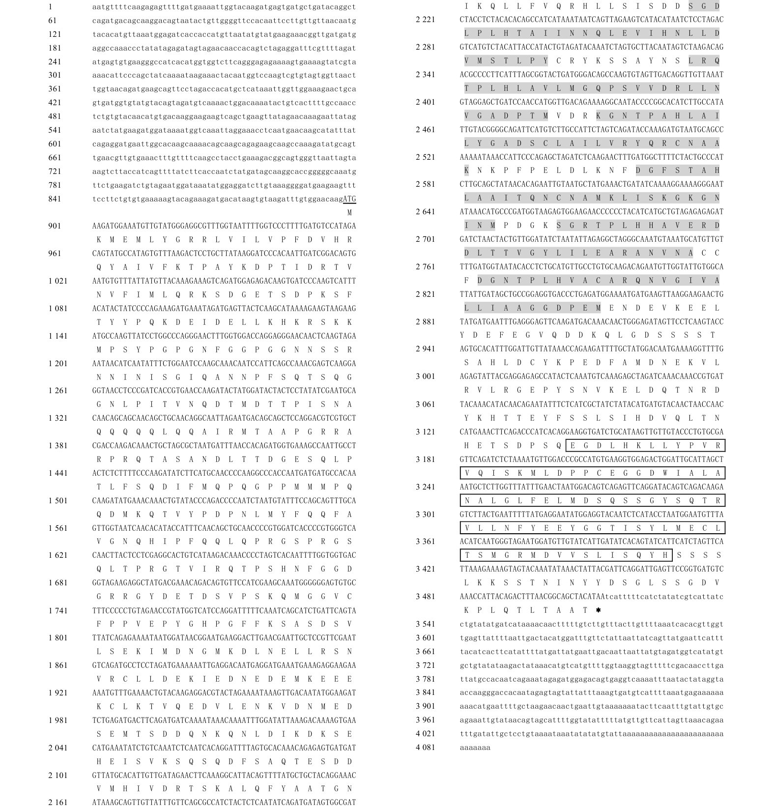
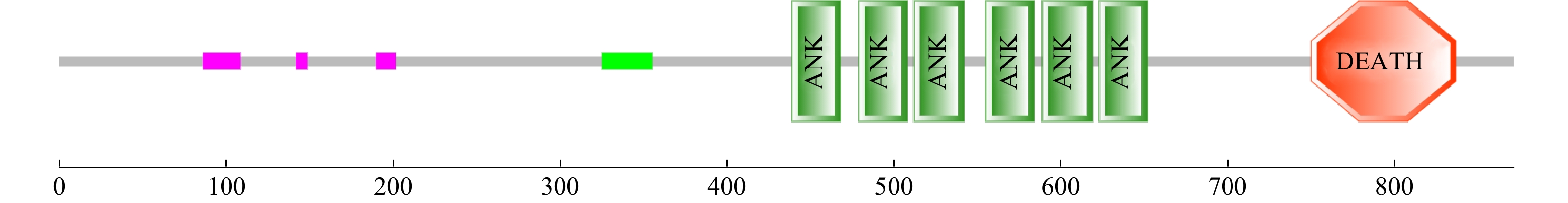
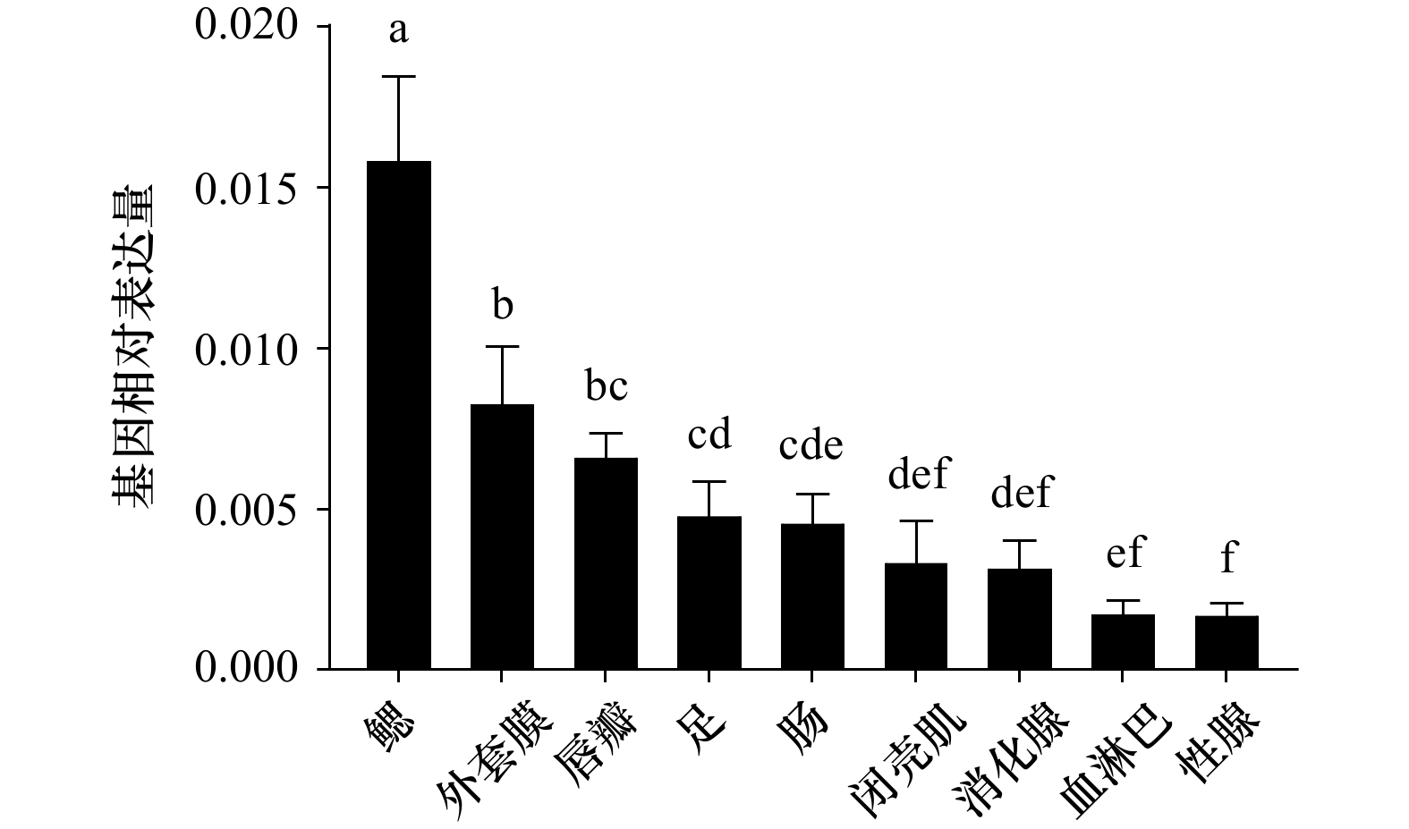
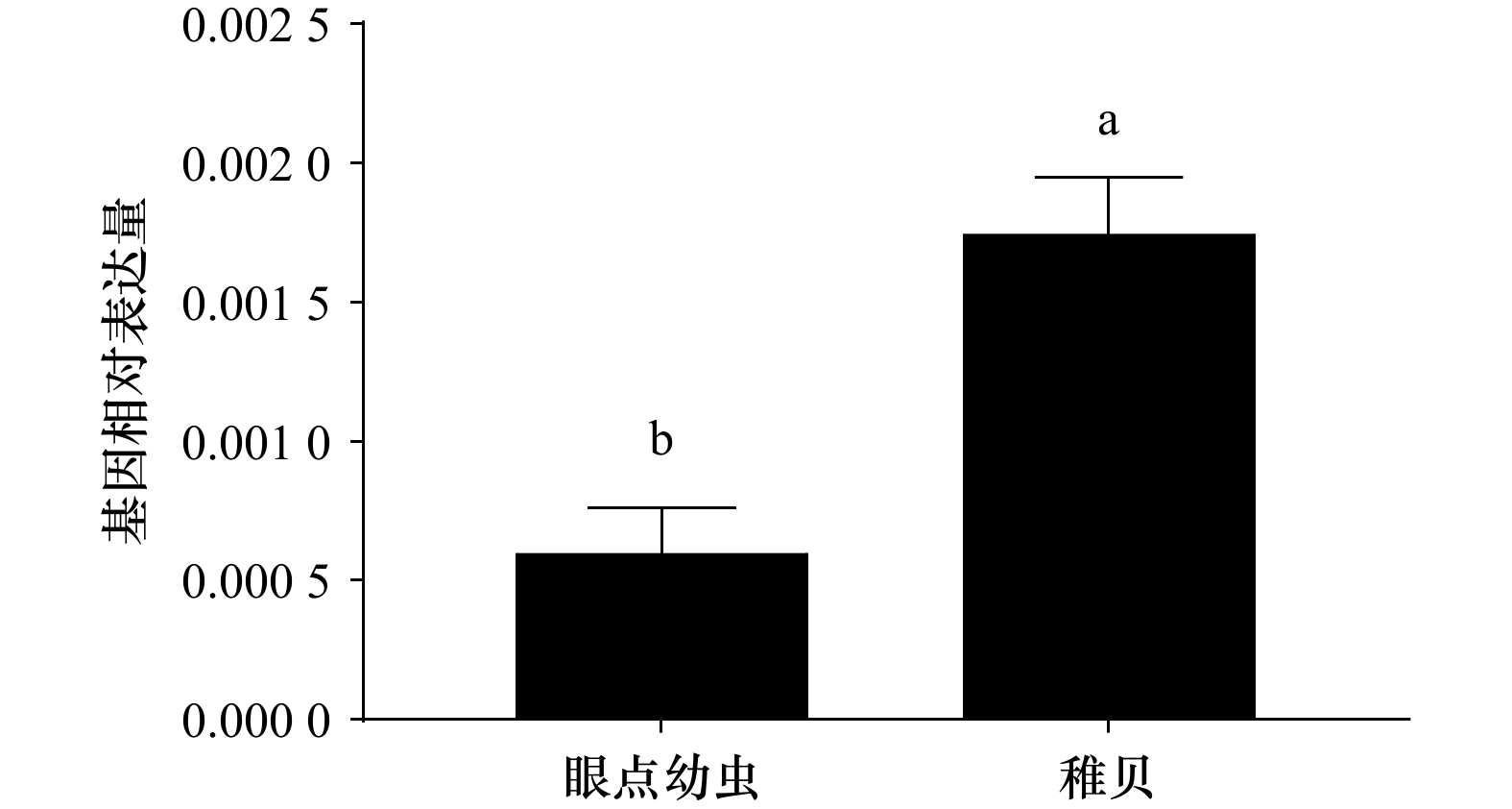
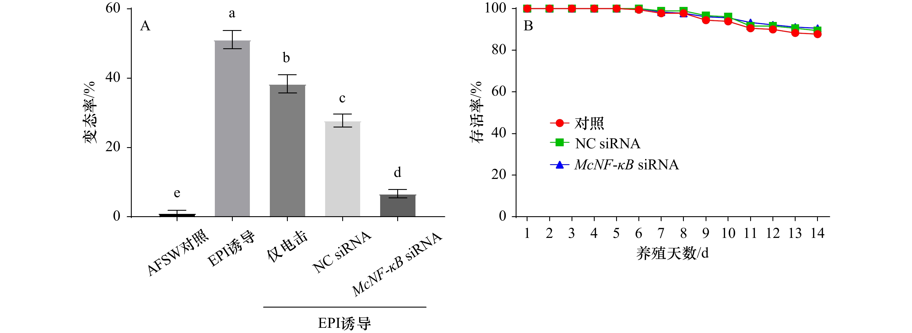
Nuclear factor κB (NF-κB) can regulate immunity, inflammation, apoptosis, cell proliferation, and organism development. At present, NF-κB has been well studied in vertebrates and fruit flies, while its role in shellfish is still elusive. In order to further explore the role of NF-κB in the immunity and development of mussel Mytilus coruscus, the full length McNF-κB cDNA sequence was cloned from M. coruscus. McNF-κB gene was 4087 bp long, and the open reading frame was 2 613 bp, encoding 871 amino acids and had a typical ankyrinrepeat (ANK) domain and DEATH domain. The results of amino acid sequence analysis showed that the gene had 72.76% homology with M. edulis and 66.58% with M. galloprovincialis, respectively, and was clustered with M. edulis and M. galloprovincialis in the phylogenetic tree. The real-time PCR (qRT-PCR) technology showed that the McNF-κB gene was expressed distributed in all tissues of M. coruscus, and the expression was the highest in the gill. McNF-κB gene was expressed in both the pediveliger larvae stage and the juvenile stage of M. coruscus, and the expression was significantly higher in the pediveliger larvae stage than that in the juvenile stage. After using RNA interference technology to silence the McNF-κB gene of pediveliger larvae, the larval metamorphosis rate decreased significantly, indicating that this gene was involved in regulating the metamorphosis process of M. coruscus. This study provides a basis for exploring how McNF-κB gene regulates development of M. coruscus.
Nuclear factor κB (NF-κB) can regulate immunity, inflammation, apoptosis, cell proliferation, and organism development. At present, NF-κB has been well studied in vertebrates and fruit flies, while its role in shellfish is still elusive. In order to further explore the role of NF-κB in the immunity and development of mussel Mytilus coruscus, the full length McNF-κB cDNA sequence was cloned from M. coruscus. McNF-κB gene was 4087 bp long, and the open reading frame was 2 613 bp, encoding 871 amino acids and had a typical ankyrinrepeat (ANK) domain and DEATH domain. The results of amino acid sequence analysis showed that the gene had 72.76% homology with M. edulis and 66.58% with M. galloprovincialis, respectively, and was clustered with M. edulis and M. galloprovincialis in the phylogenetic tree. The real-time PCR (qRT-PCR) technology showed that the McNF-κB gene was expressed distributed in all tissues of M. coruscus, and the expression was the highest in the gill. McNF-κB gene was expressed in both the pediveliger larvae stage and the juvenile stage of M. coruscus, and the expression was significantly higher in the pediveliger larvae stage than that in the juvenile stage. After using RNA interference technology to silence the McNF-κB gene of pediveliger larvae, the larval metamorphosis rate decreased significantly, indicating that this gene was involved in regulating the metamorphosis process of M. coruscus. This study provides a basis for exploring how McNF-κB gene regulates development of M. coruscus.


2023, 45(9): 152-167.
doi: 10.12284/hyxb2023118
Abstract:
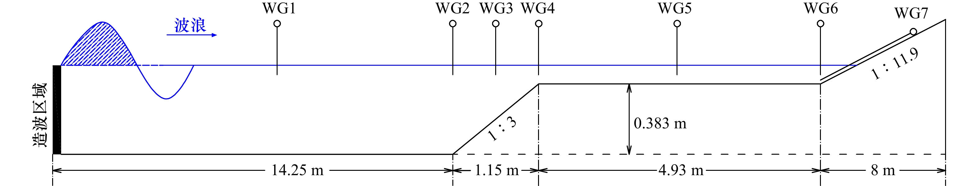
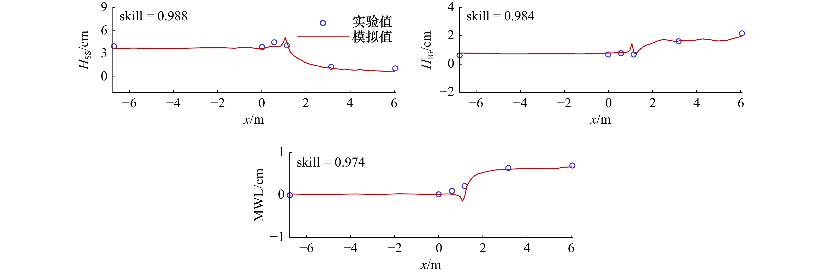
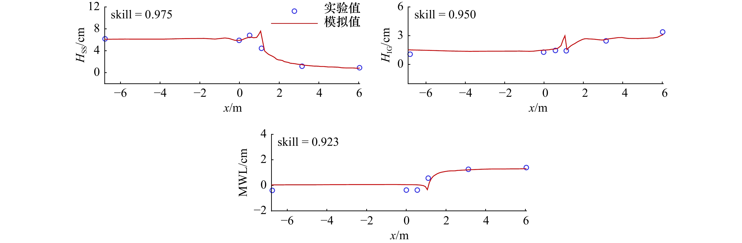
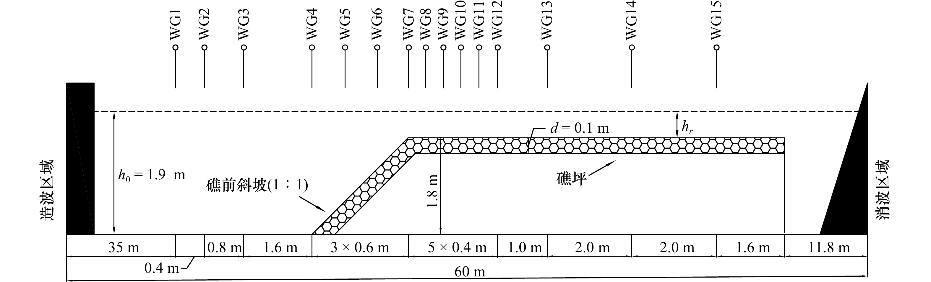
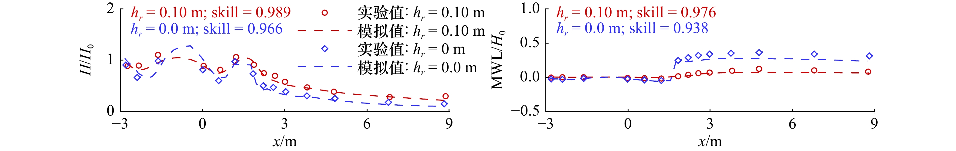
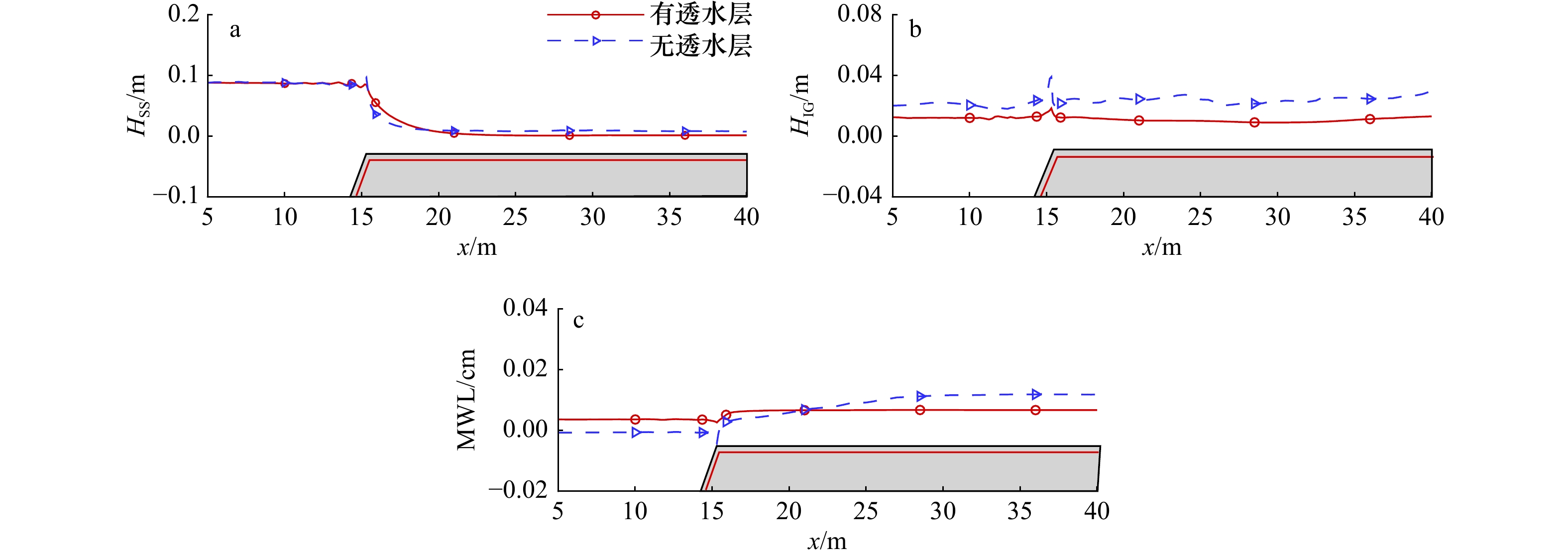
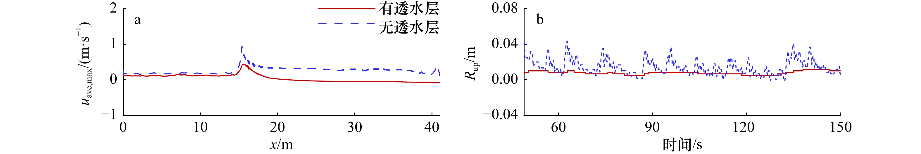
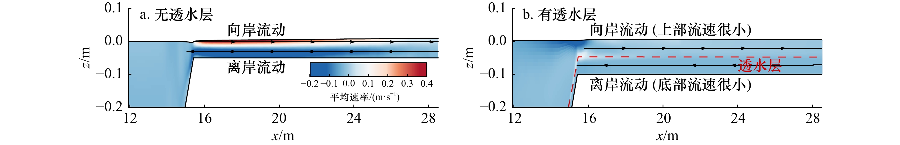
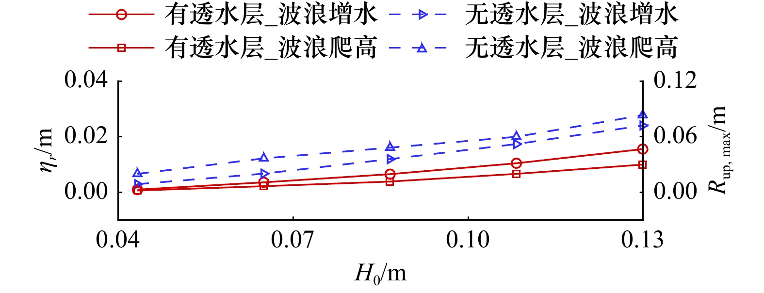
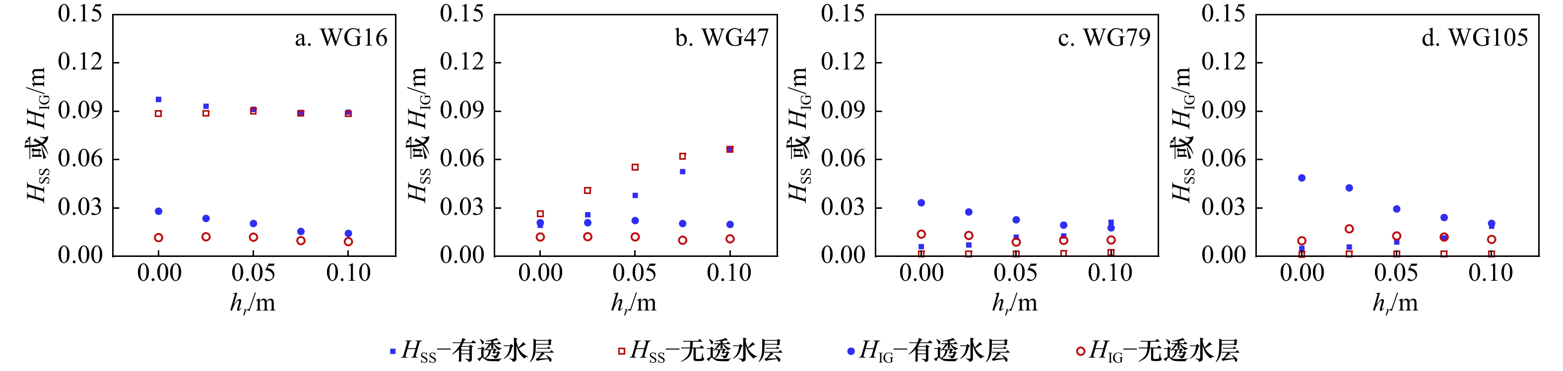
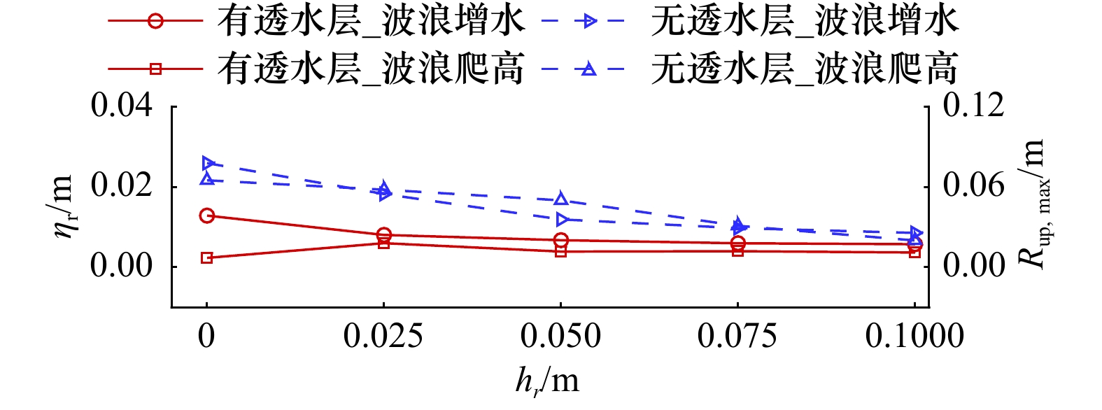
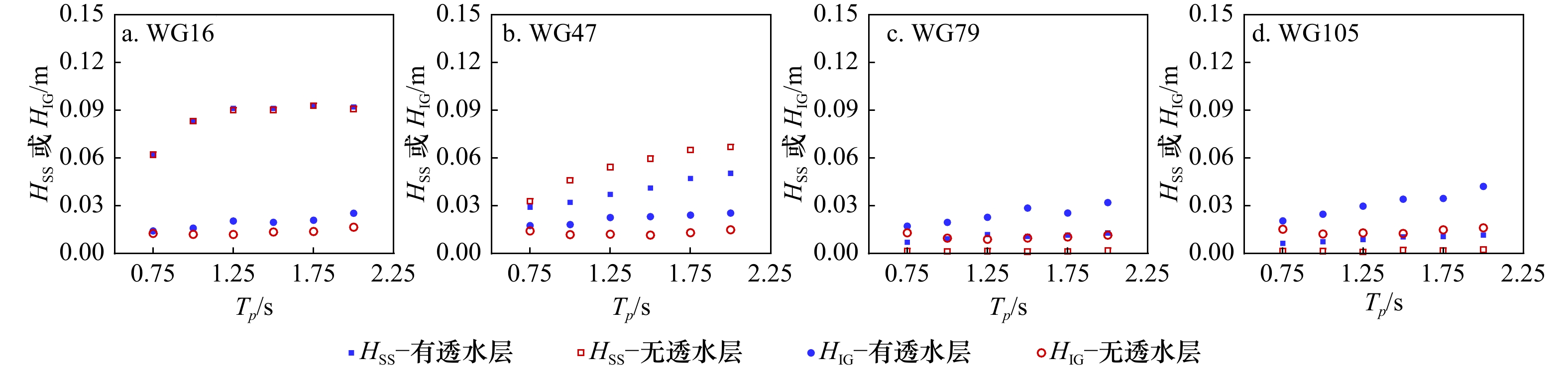
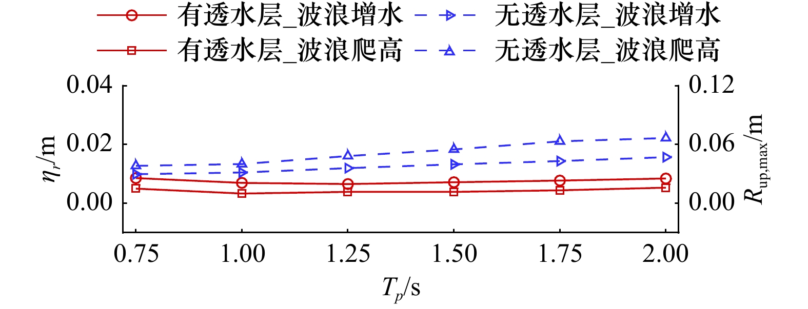
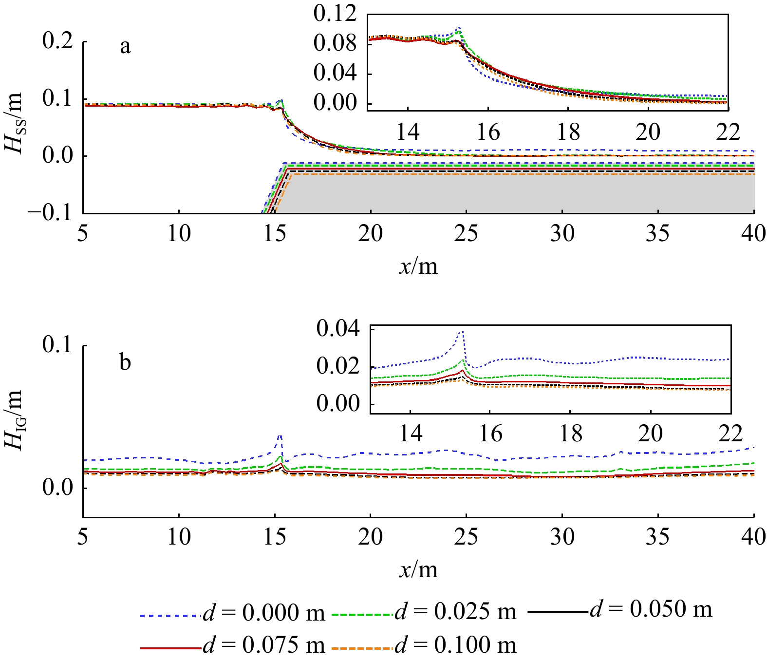
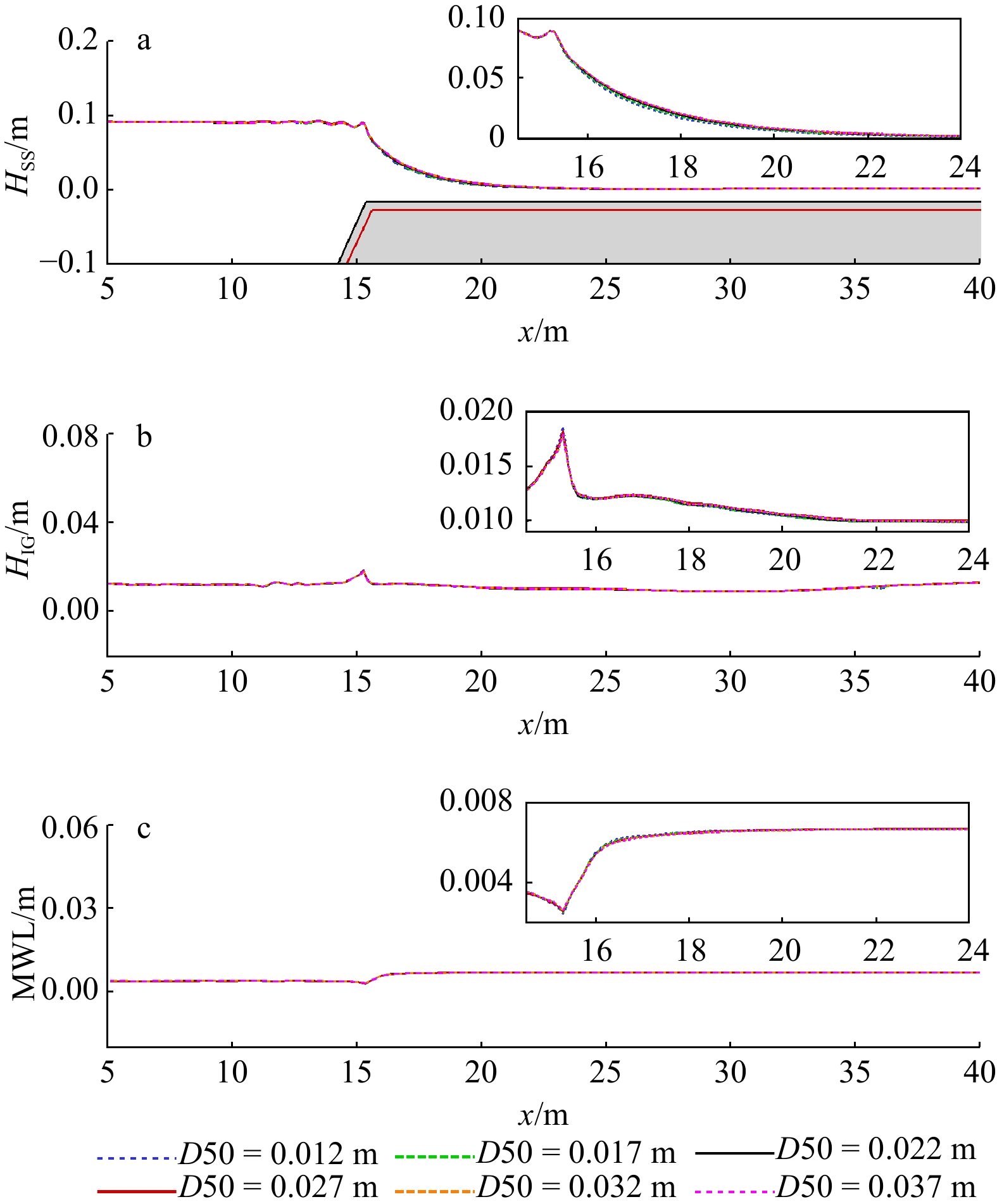
Based on the nonhydrostatic single-phase flow numerical wave model (NHWAVE), the propagation of random waves on a permeable fringing reef is simulated numerically, and the effects of incident wave height, water depth on reef flat, spectrum peak period, thickness of permeable layer, porosity and median diameters the hydrodynamic characteristics of waves on the fringing reef are considered comprehensively, focusing on the variation of sea-swell wave height, infragravity wave height and mean water level along the reef, and comparing with that of the fringing reef without permeable layer. The study shows that the existence of the permeable layer has a significant impact on the hydrodynamic characteristics of waves on the fringing reef. The study shows that the existence of the permeable layer reduces the shallow water deformation of waves on the slope in front of the reef and the wave breaking near the reef edge, and significantly decreases the sea-swell wave height, infragravity wave height, and wave setup near the shoreline, in addition to that, the existence of the permeable layer reduces the maximum wave runup on the shoreline. The greater the incident wave height and spectrum peak period, the more significant the effect of the permeable layer on the sea-swell wave, infragravity wave and wave setup on the fringing reef; when the water depth of the reef is increased, the effect of the permeable layer on wave attenuation is weakened; as the thickness of the permeable layer increases, the values of sea-swell wave height, infragravity wave height and wave setup near the shoreline decrease.
Based on the nonhydrostatic single-phase flow numerical wave model (NHWAVE), the propagation of random waves on a permeable fringing reef is simulated numerically, and the effects of incident wave height, water depth on reef flat, spectrum peak period, thickness of permeable layer, porosity and median diameters the hydrodynamic characteristics of waves on the fringing reef are considered comprehensively, focusing on the variation of sea-swell wave height, infragravity wave height and mean water level along the reef, and comparing with that of the fringing reef without permeable layer. The study shows that the existence of the permeable layer has a significant impact on the hydrodynamic characteristics of waves on the fringing reef. The study shows that the existence of the permeable layer reduces the shallow water deformation of waves on the slope in front of the reef and the wave breaking near the reef edge, and significantly decreases the sea-swell wave height, infragravity wave height, and wave setup near the shoreline, in addition to that, the existence of the permeable layer reduces the maximum wave runup on the shoreline. The greater the incident wave height and spectrum peak period, the more significant the effect of the permeable layer on the sea-swell wave, infragravity wave and wave setup on the fringing reef; when the water depth of the reef is increased, the effect of the permeable layer on wave attenuation is weakened; as the thickness of the permeable layer increases, the values of sea-swell wave height, infragravity wave height and wave setup near the shoreline decrease.


2023, 45(9): 168-176.
doi: 10.12284/hyxb2023122
Abstract:
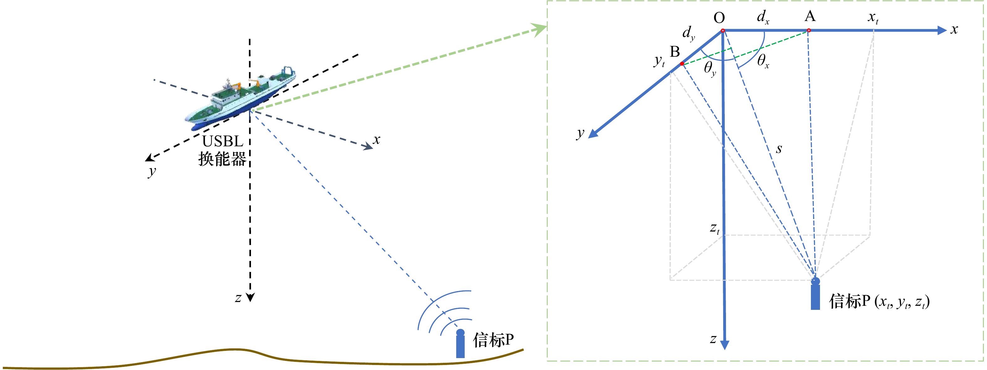
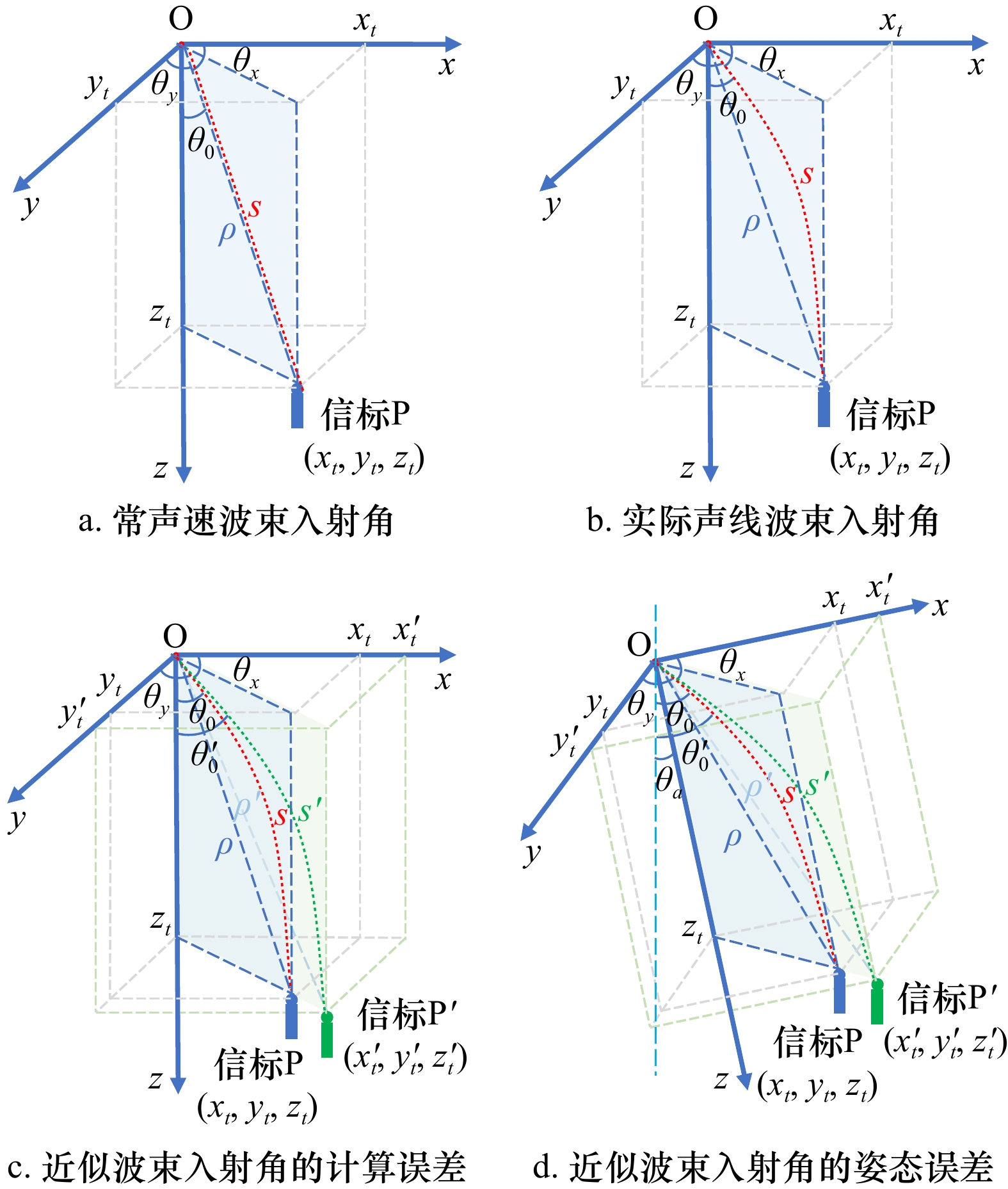
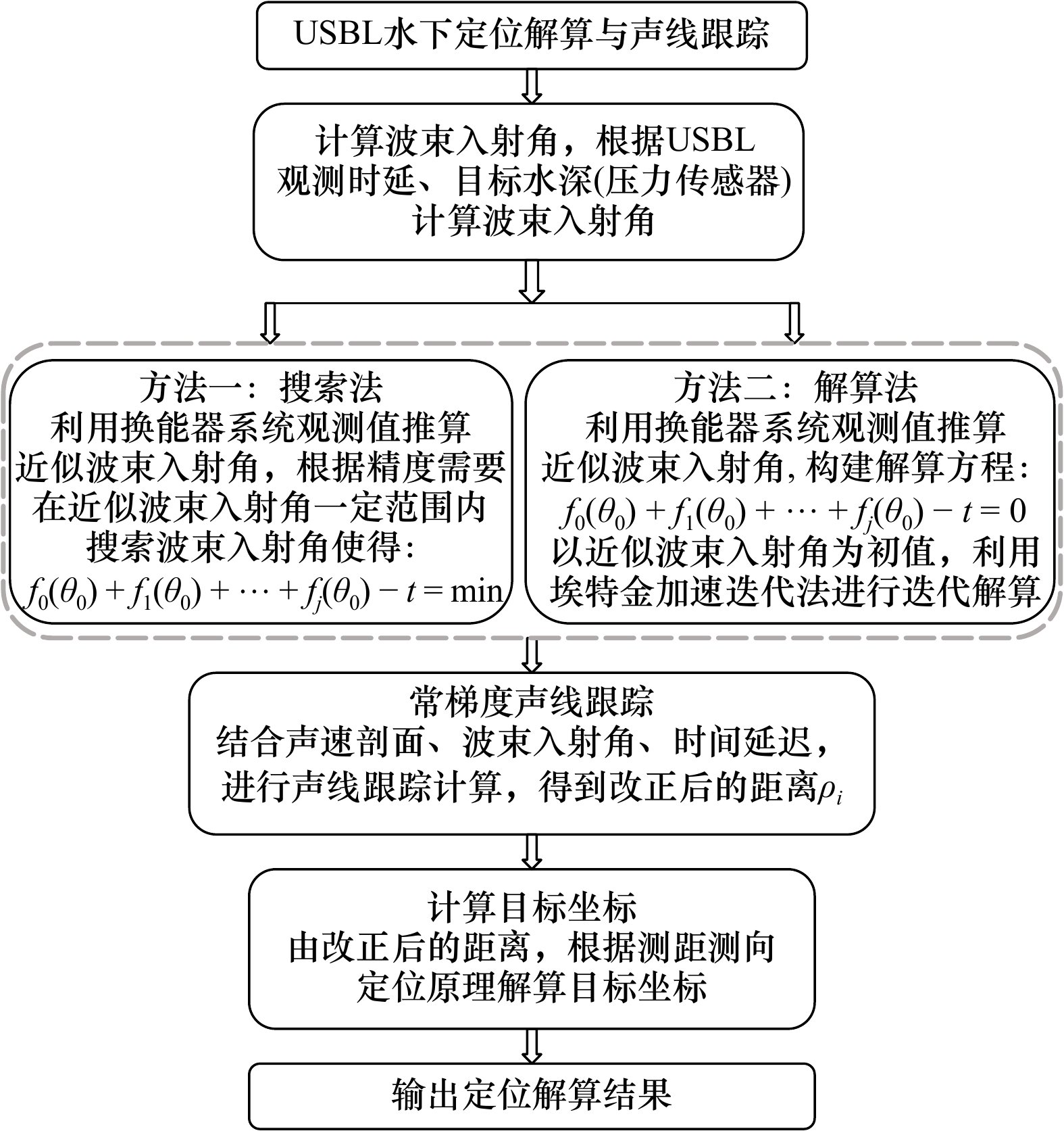
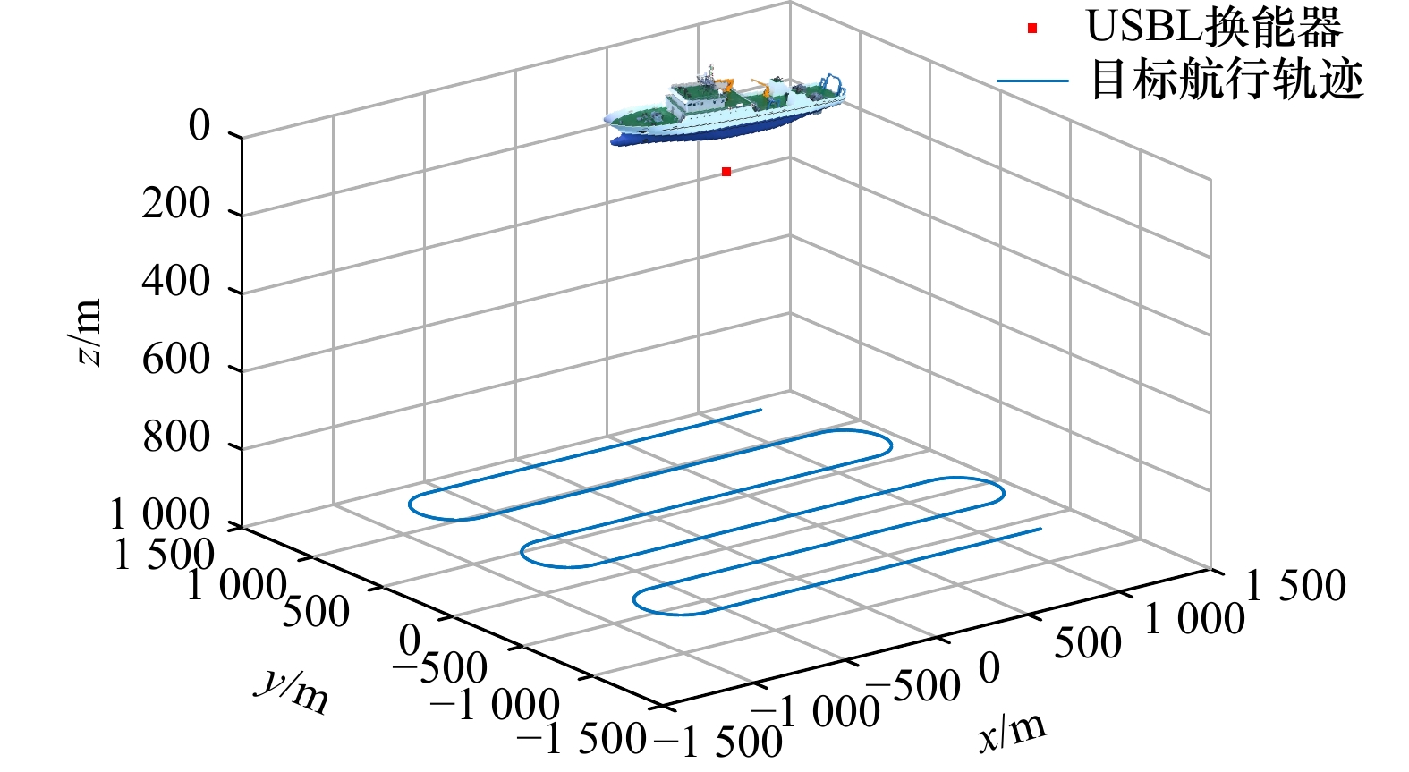
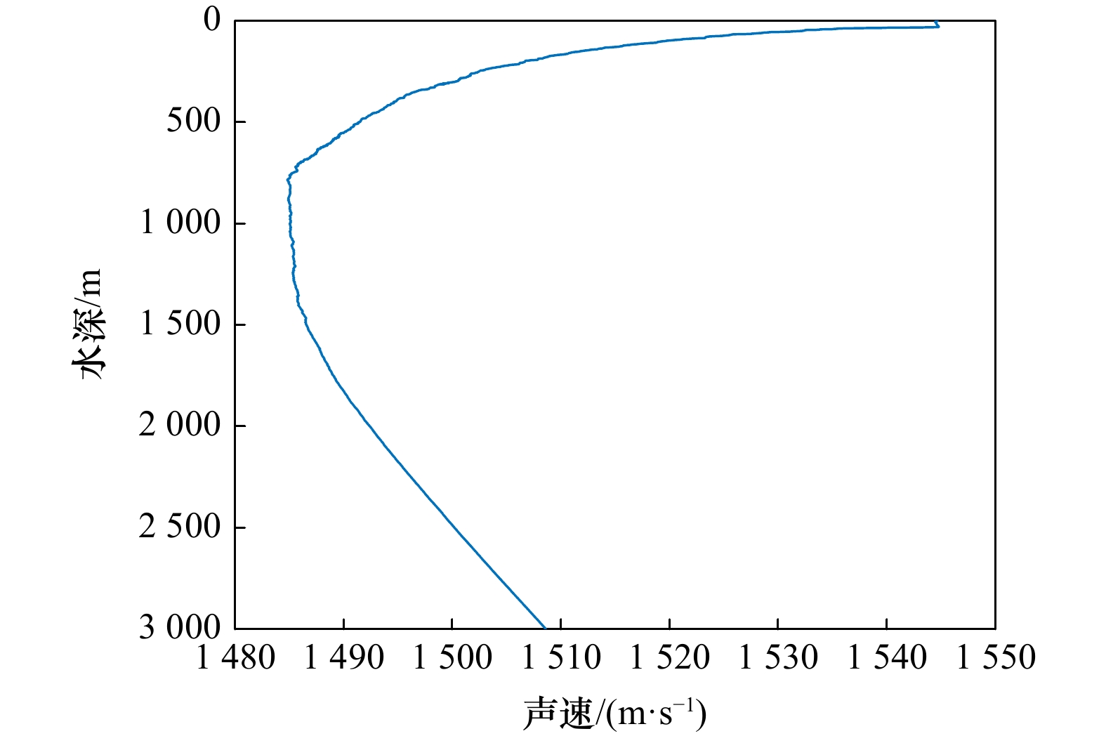
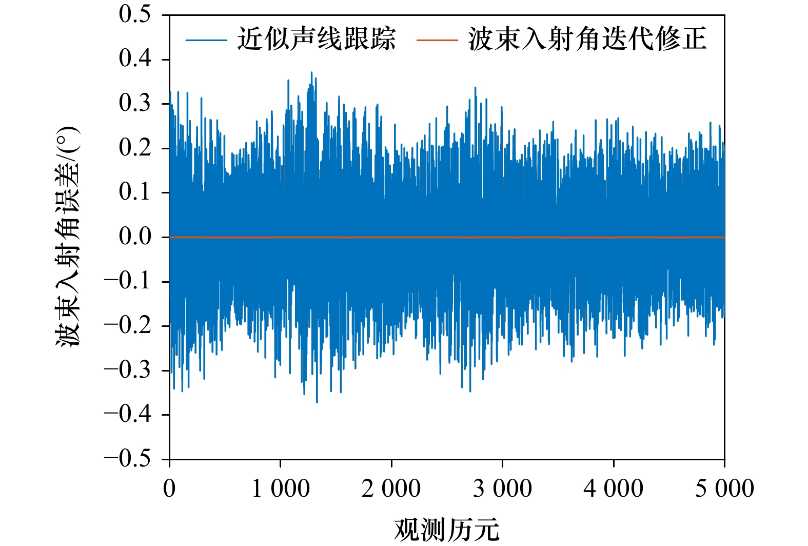
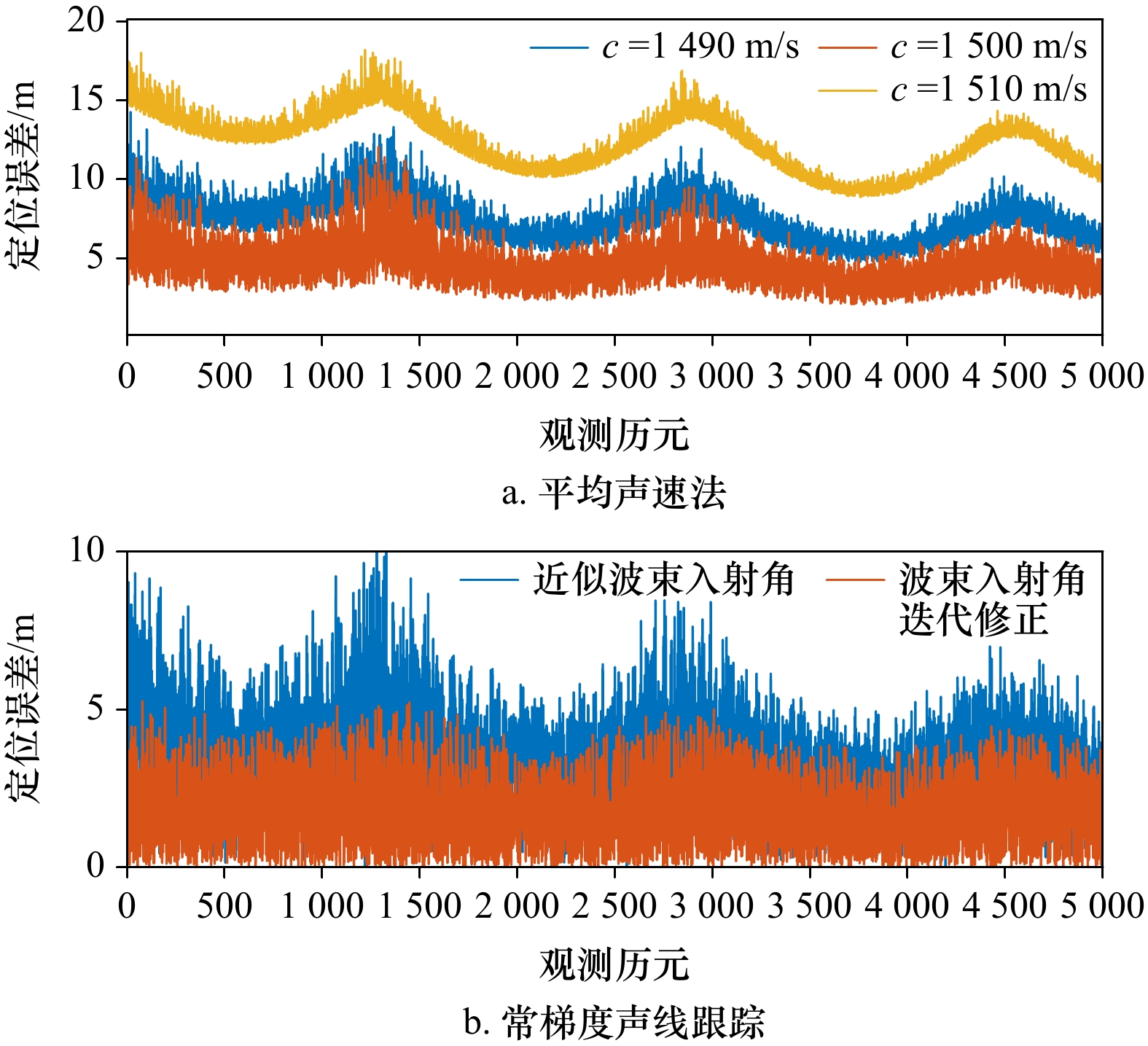
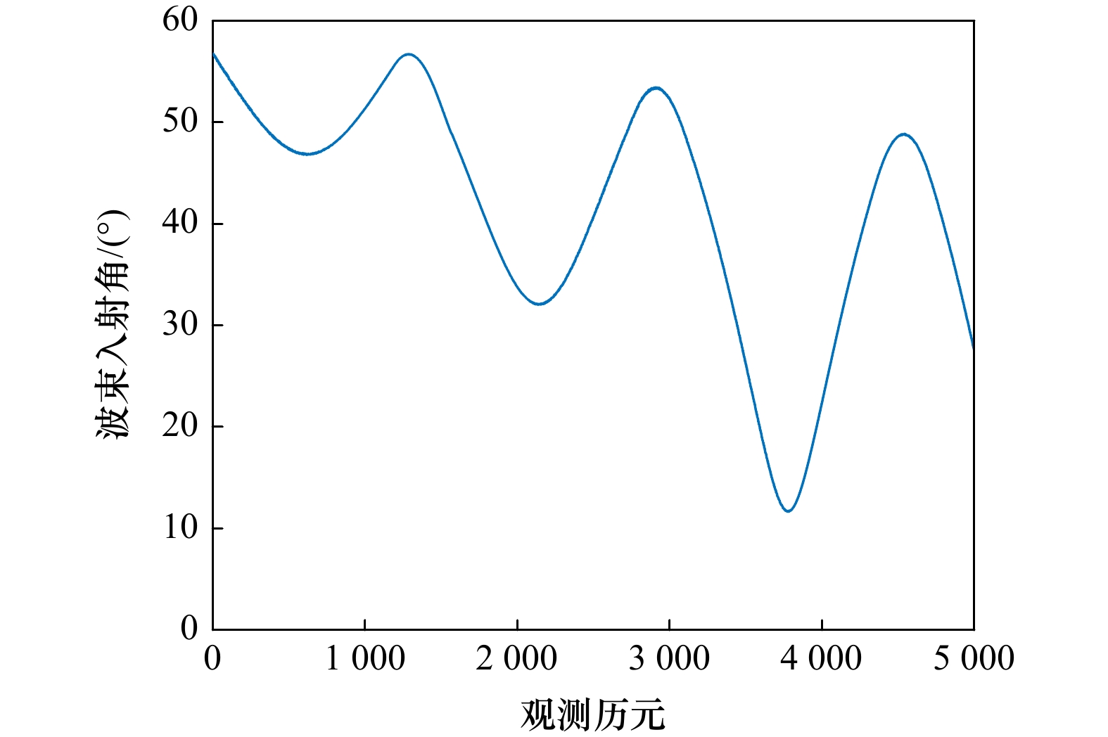
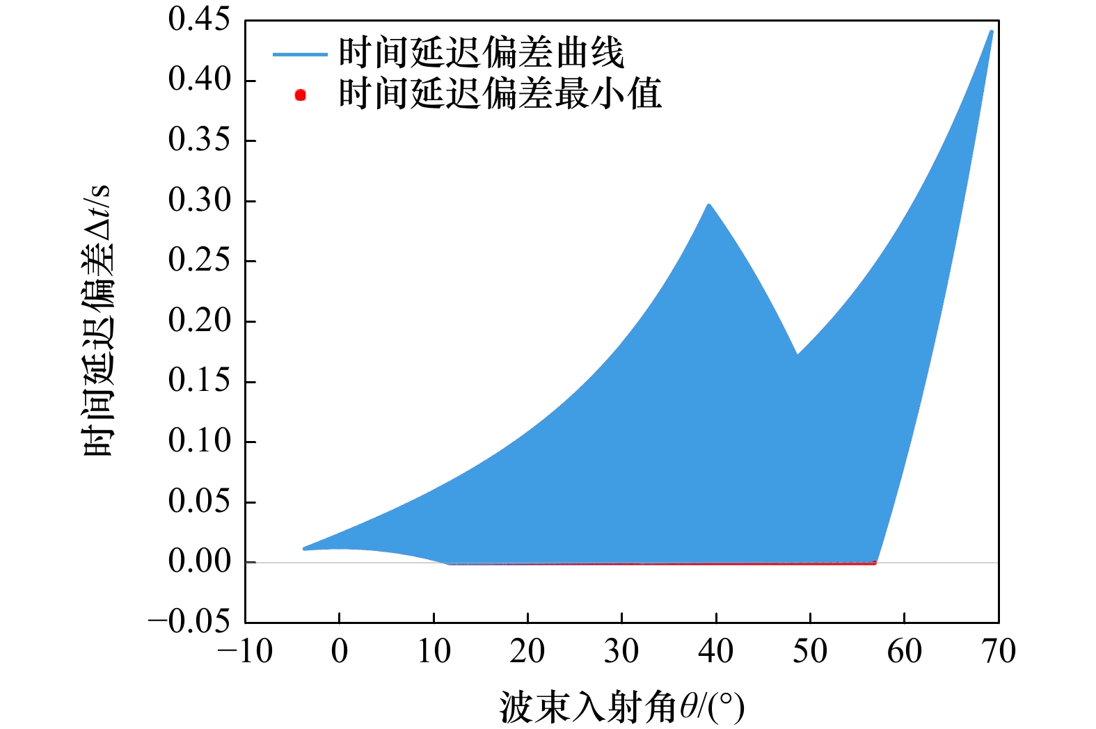
The inhomogeneity of the seawater medium causes the refraction effect in the sound wave propagation process. The ultra-short baseline system using the planar acoustic array will be affected by this phenomenon during the measurement process, which will cause large errors in the measurement results. The sound ray tracking method is usually used to correct the sound ray by using the measured sound velocity profile. Accurate beam incident angle is the prerequisite to ensure the accuracy of sound ray tracking, but the ultra-short baseline system does not directly measure the beam incident angle but uses the approximate incident angle derived from the acoustic phase difference for sound ray tracking will cause a certain loss of accuracy. To solve the above problems, this paper proposes an iterative correction method of beam incidence angle for ultra-short baseline underwater acoustic positioning. Based on constant gradient acoustic ray tracking, the iterative calculation relationship between beam incidence angle and propagation time is constructed, the Aitken acceleration method is used to quickly solve the nonlinear equation of the beam incidence angle. Simulation experiments prove that the method proposed in this paper can accurately calculate the beam incident angle and target position, and effectively eliminate the influence of refraction effects on ultra-short baseline underwater positioning.
The inhomogeneity of the seawater medium causes the refraction effect in the sound wave propagation process. The ultra-short baseline system using the planar acoustic array will be affected by this phenomenon during the measurement process, which will cause large errors in the measurement results. The sound ray tracking method is usually used to correct the sound ray by using the measured sound velocity profile. Accurate beam incident angle is the prerequisite to ensure the accuracy of sound ray tracking, but the ultra-short baseline system does not directly measure the beam incident angle but uses the approximate incident angle derived from the acoustic phase difference for sound ray tracking will cause a certain loss of accuracy. To solve the above problems, this paper proposes an iterative correction method of beam incidence angle for ultra-short baseline underwater acoustic positioning. Based on constant gradient acoustic ray tracking, the iterative calculation relationship between beam incidence angle and propagation time is constructed, the Aitken acceleration method is used to quickly solve the nonlinear equation of the beam incidence angle. Simulation experiments prove that the method proposed in this paper can accurately calculate the beam incident angle and target position, and effectively eliminate the influence of refraction effects on ultra-short baseline underwater positioning.

2023, 45(9): 177-188.
doi: 10.12284/hyxb2023110
Abstract:
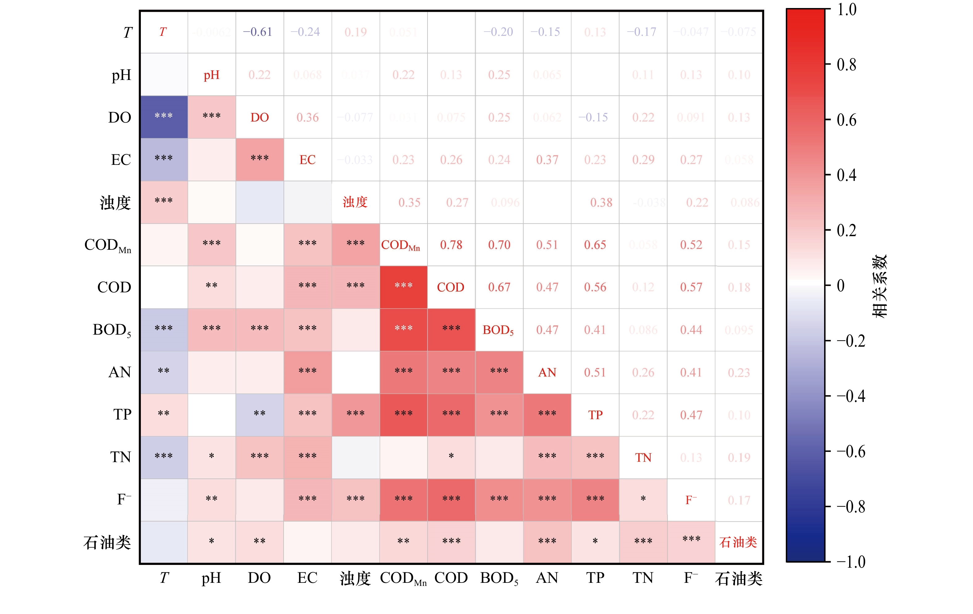
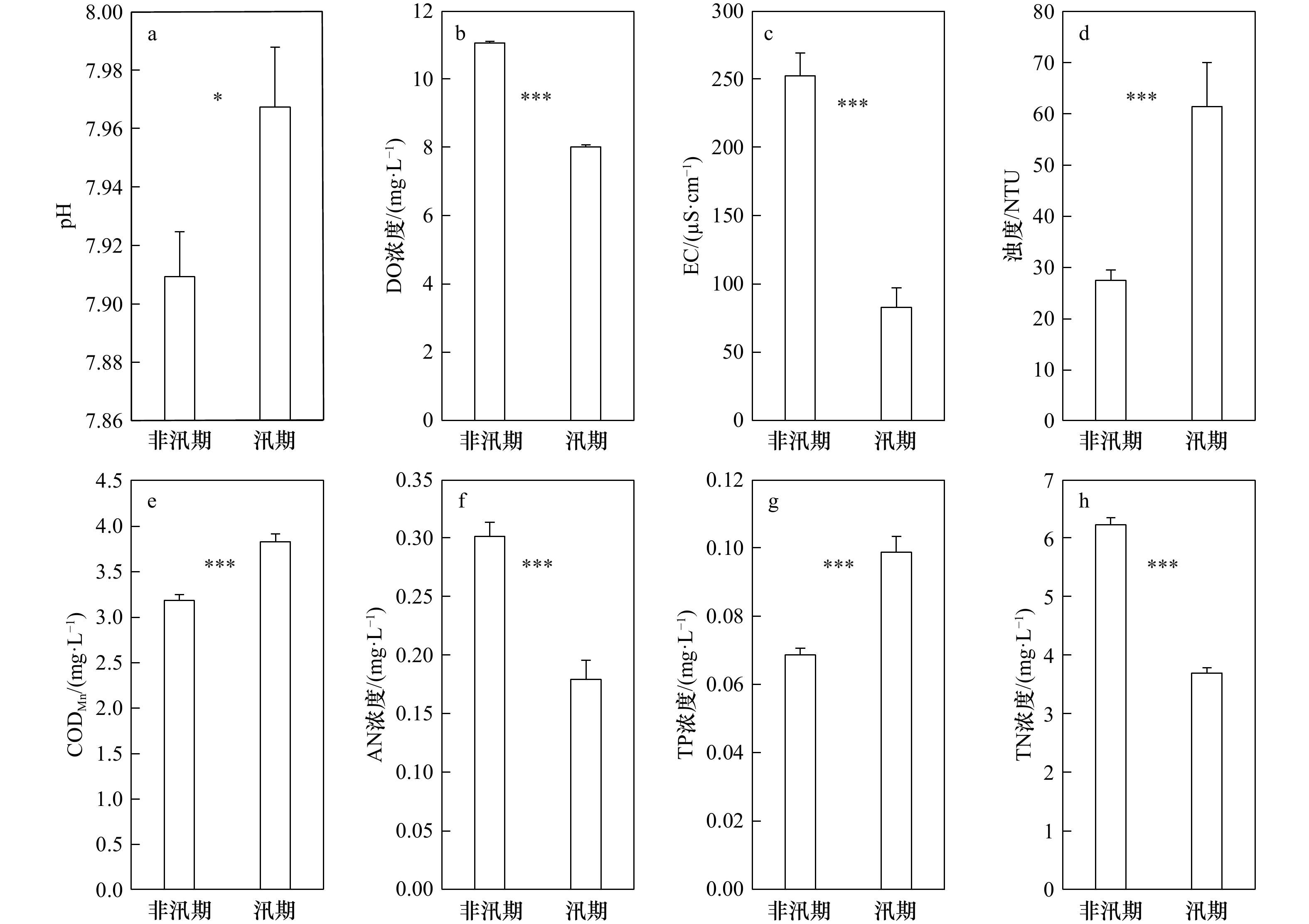
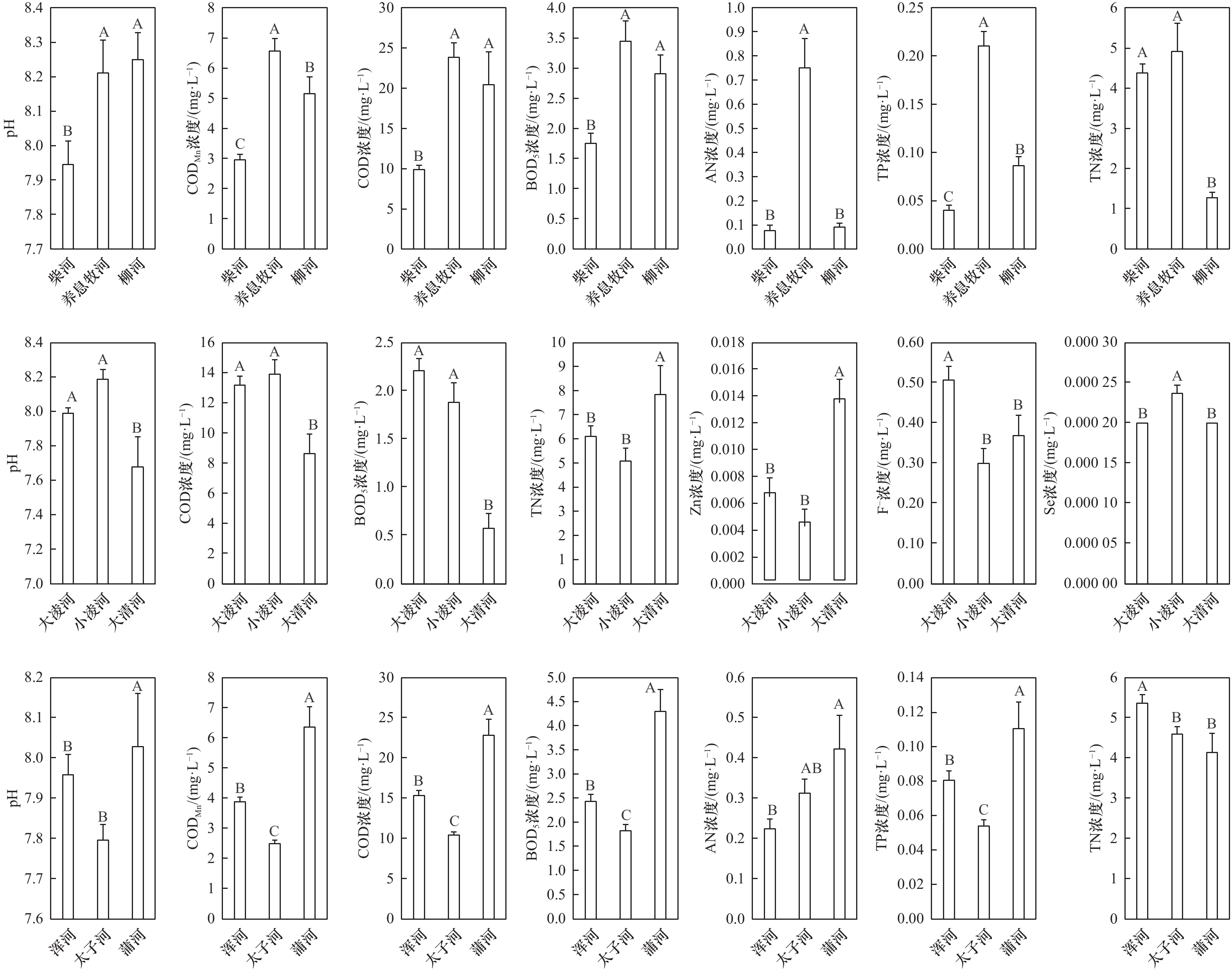
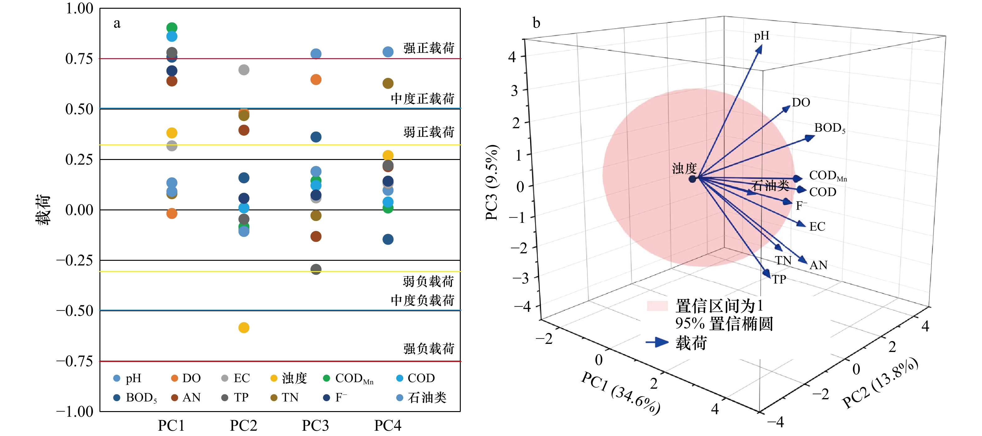
Based on the dataset of 120 water quality monitoring sites (including 16 coastal sites) in rivers along Liaodong Bay, the principal component analysis-multiple linear regression (PCA-MLR) model was used to study the pollution characteristics and flux of organic matter, nutrients and heavy metals, and analyze their possible sources. The pollutants exceeding the first grade of Environmental Quality Standards for Surface Water were CODMn, AN concentration. TP concentration and TN concentration, and other water quality parameters met the standard. The TN/TP ratios were high and seriously deviated from the Redfield ratio. The input of high N and low P load from terrestrial sources was the main factor causing the increase of TN/TP in Bohai Sea. DO concentration, EC, AN concentration and TN concentration in non-flood season increased significantly than in flood season, while pH, turbidity, CODMn and TP concentration in non-flood season decreased significantly than in flood season. The concentrations of organic matter and nutrients in estuaries were affected by factors such as the agricultural areas that rivers flowed, while the concentrations of heavy metals were related to the distribution of industrial enterprises in the region. The annual fluxes of TN, TP, COD, AN and petroleum pollutant into Liaodong Bay were 3.63 × 10⁴ t, 1 608.5 t, 14.8 ×10⁴ t, 3 086.6 t and 221.9 t, respectively, and the fluxes of Hg, Cd, Pb, As and Cr6+ were 0.264 t, 0.253 t, 1.978 t, 20.434 t and 31.651 t, respectively. According to their contribution, the main pollution sources were domestic sewage and industrial wastewater, sources caused by hydrological factors (hydrodynamic conditions, etc.), water-gas interface pollutants exchange and secondary sources, non-point sources of farmland runoff and transportation.
Based on the dataset of 120 water quality monitoring sites (including 16 coastal sites) in rivers along Liaodong Bay, the principal component analysis-multiple linear regression (PCA-MLR) model was used to study the pollution characteristics and flux of organic matter, nutrients and heavy metals, and analyze their possible sources. The pollutants exceeding the first grade of Environmental Quality Standards for Surface Water were CODMn, AN concentration. TP concentration and TN concentration, and other water quality parameters met the standard. The TN/TP ratios were high and seriously deviated from the Redfield ratio. The input of high N and low P load from terrestrial sources was the main factor causing the increase of TN/TP in Bohai Sea. DO concentration, EC, AN concentration and TN concentration in non-flood season increased significantly than in flood season, while pH, turbidity, CODMn and TP concentration in non-flood season decreased significantly than in flood season. The concentrations of organic matter and nutrients in estuaries were affected by factors such as the agricultural areas that rivers flowed, while the concentrations of heavy metals were related to the distribution of industrial enterprises in the region. The annual fluxes of TN, TP, COD, AN and petroleum pollutant into Liaodong Bay were 3.63 × 10⁴ t, 1 608.5 t, 14.8 ×10⁴ t, 3 086.6 t and 221.9 t, respectively, and the fluxes of Hg, Cd, Pb, As and Cr6+ were 0.264 t, 0.253 t, 1.978 t, 20.434 t and 31.651 t, respectively. According to their contribution, the main pollution sources were domestic sewage and industrial wastewater, sources caused by hydrological factors (hydrodynamic conditions, etc.), water-gas interface pollutants exchange and secondary sources, non-point sources of farmland runoff and transportation.


 Email alert
 RSS
RSS