


2023 Vol. 45, No. 2
Display Method:
2023, 45(2): 1-12.
doi: 10.12284/hyxb2023001
Abstract:
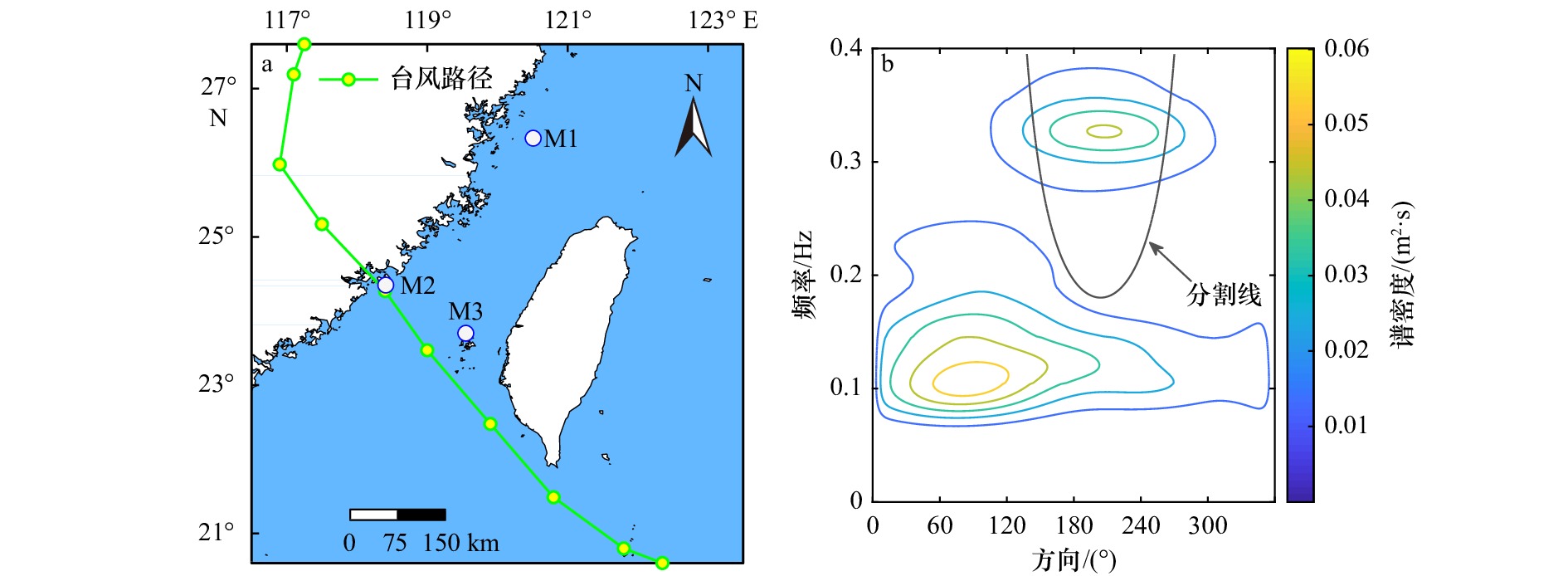
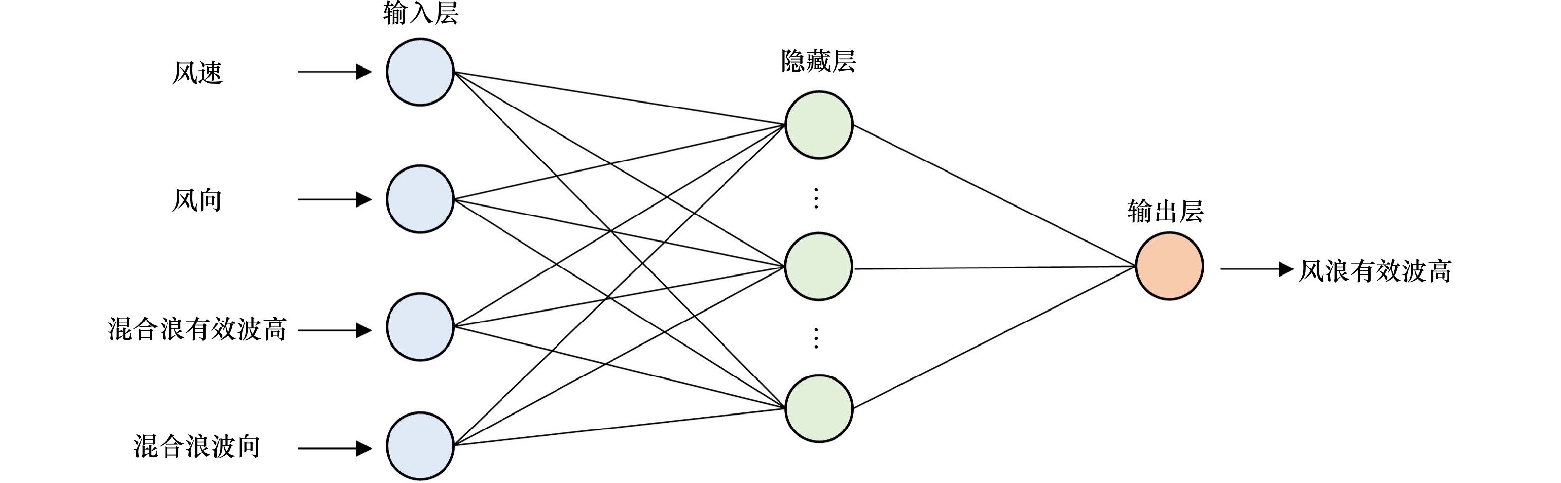
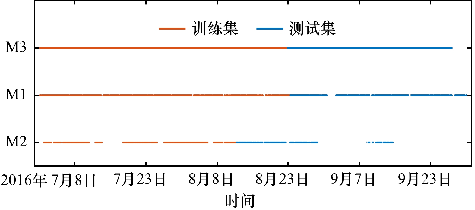
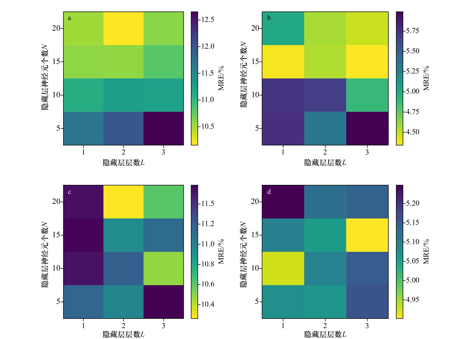
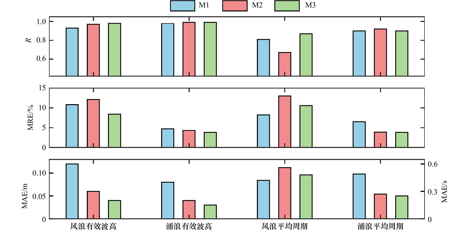
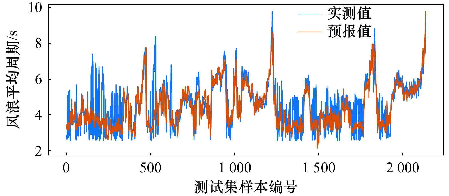
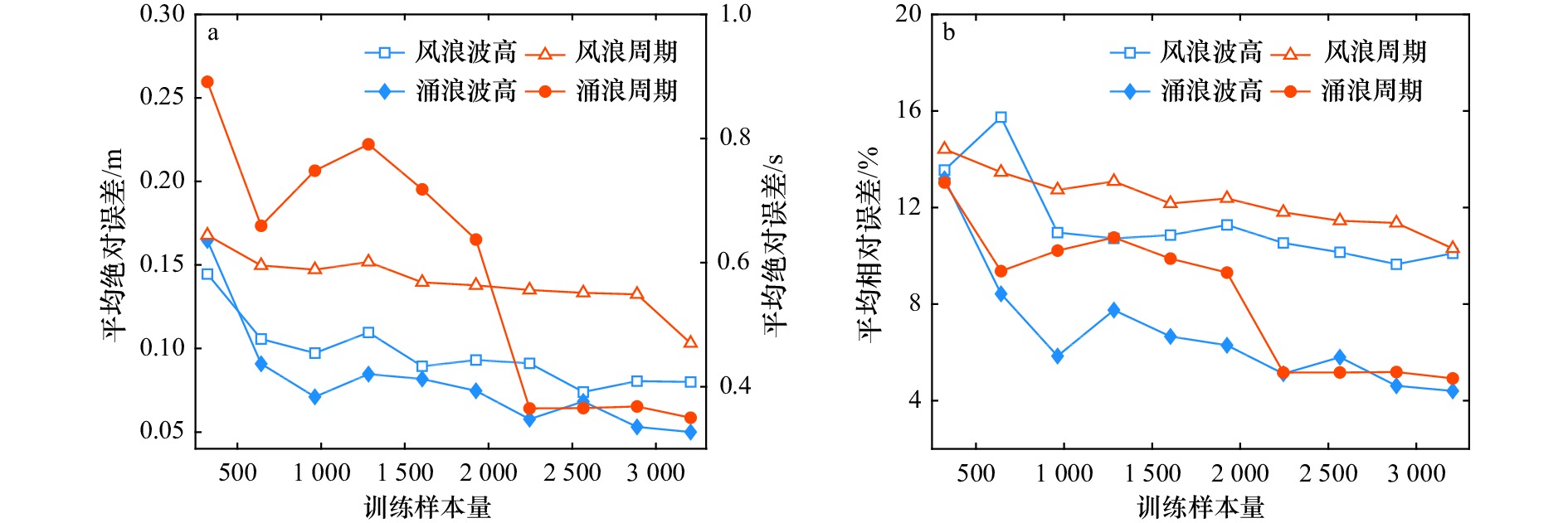
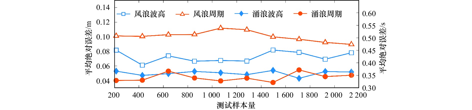
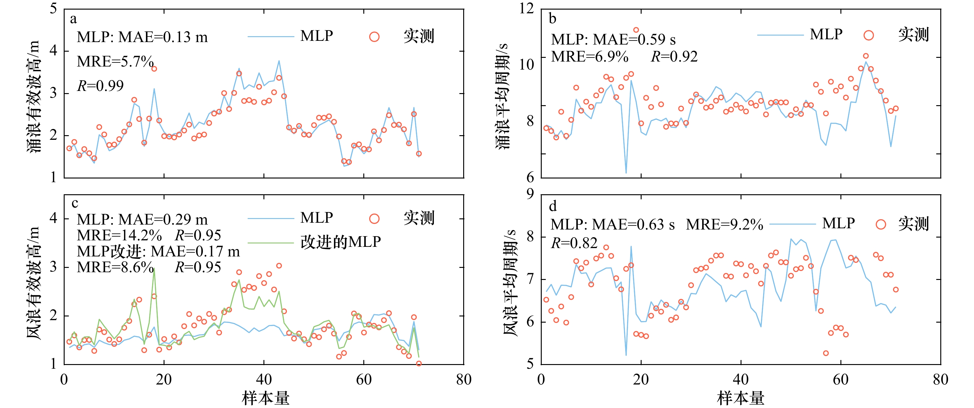
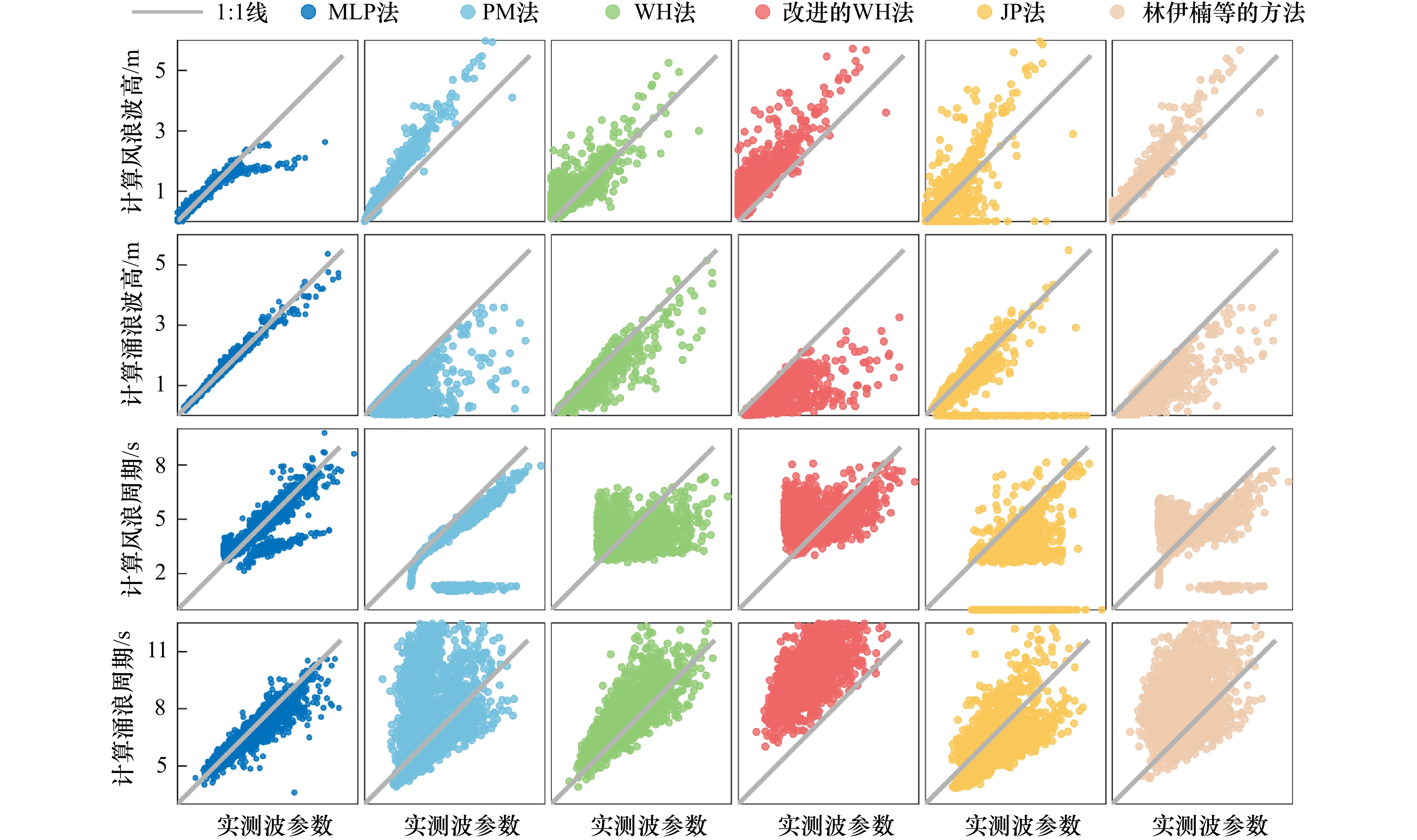
Separation of wind-wave and swell is the basis for studying the respective characteristics of wind-wave and swell. However, due to the lack of wave spectrum data, it is difficult to popularize and apply separation methods based on wave spectrums. An effective solution is to use wave observations that are easy to obtain, namely basic wave elements to separate wind-wave and swell. Existing methods cannot use basic wave elements to comprehensively calculate the proportions and characteristic parameters of wind-wave and swell. For this reason, this paper introduces machine learning into the separation of wind-wave and swell. Based on the multi-layer perceptron model, a method using wave elements and wind elements to accurately estimate wind-wave and swell parameters is proposed. This method requires each station to provide at least 466 training samples of wave data and 766 or more training samples are recommended. The method is suitable for 3 stations in the Taiwan Strait with its accuracy significantly better than traditional methods based on wave spectrums. The proposed method can provide alternative calculation schemes of wind-wave and swell for stations lacking wave spectrums in this sea area. It helps expand the source of measured data of wind-wave and swell, therefore strengthening the research on the characteristics and early warning and forecasting of wind-wave and swell.
Separation of wind-wave and swell is the basis for studying the respective characteristics of wind-wave and swell. However, due to the lack of wave spectrum data, it is difficult to popularize and apply separation methods based on wave spectrums. An effective solution is to use wave observations that are easy to obtain, namely basic wave elements to separate wind-wave and swell. Existing methods cannot use basic wave elements to comprehensively calculate the proportions and characteristic parameters of wind-wave and swell. For this reason, this paper introduces machine learning into the separation of wind-wave and swell. Based on the multi-layer perceptron model, a method using wave elements and wind elements to accurately estimate wind-wave and swell parameters is proposed. This method requires each station to provide at least 466 training samples of wave data and 766 or more training samples are recommended. The method is suitable for 3 stations in the Taiwan Strait with its accuracy significantly better than traditional methods based on wave spectrums. The proposed method can provide alternative calculation schemes of wind-wave and swell for stations lacking wave spectrums in this sea area. It helps expand the source of measured data of wind-wave and swell, therefore strengthening the research on the characteristics and early warning and forecasting of wind-wave and swell.
2023, 45(2): 13-26.
doi: 10.12284/hyxb2023045
Abstract:
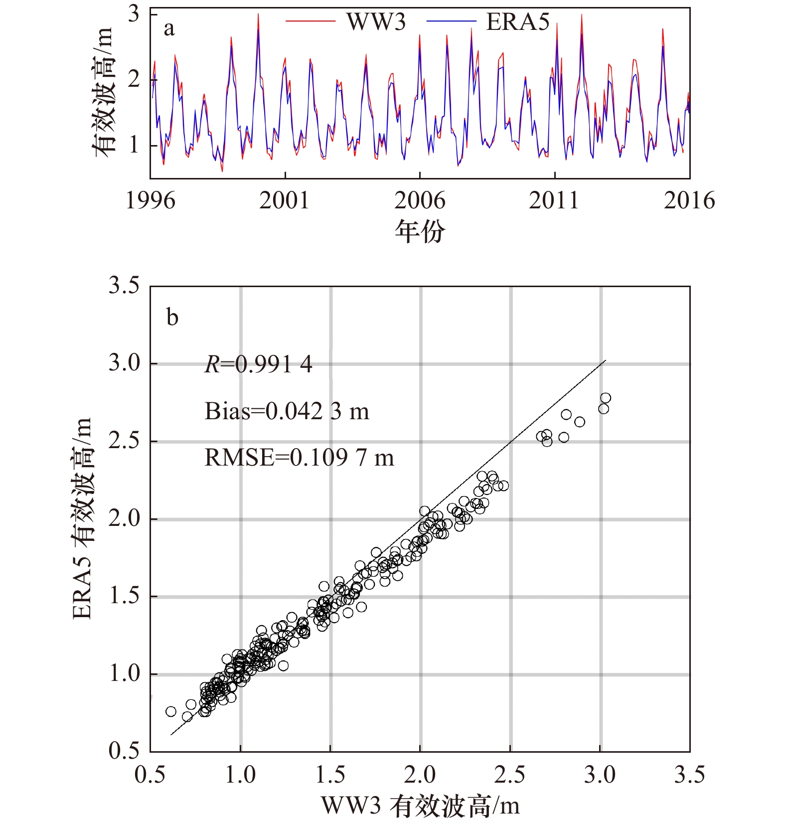
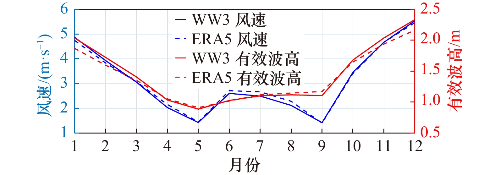
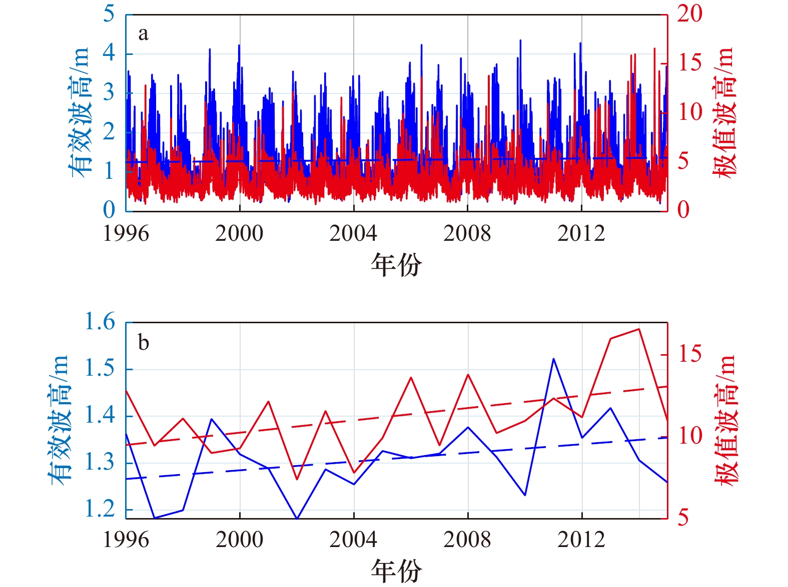
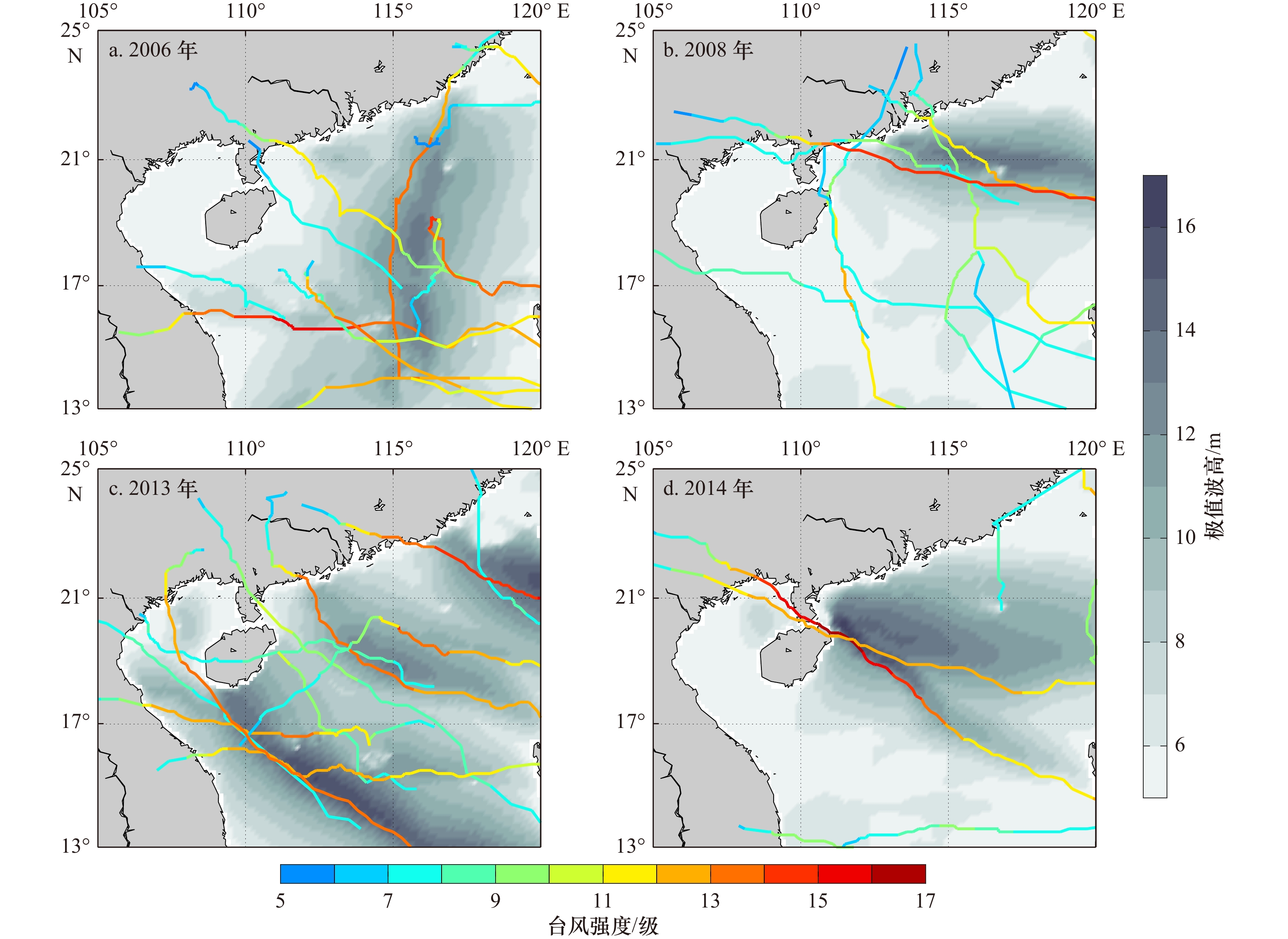
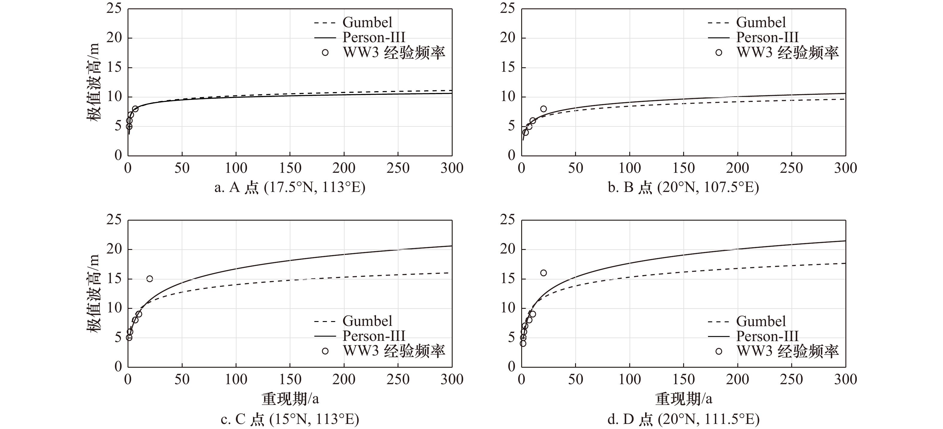
The spatio-temporal variations of significant wave height and its extremum in the northern South China Sea from 1996 to 2015 are analyzed based on the wave hindcast simulation by the third-generation wave model WaveWatch III (WW3). Two extreme value distribution methods, Pearson-III and Gumbel methods, have been used to estimate the return period of the extreme significant wave height in the northern South China Sea. The results show that the seasonal variation and spatial distribution of significant wave height in the northern South China Sea are consistent with the monsoon field, similar to the results of reanalysis data. It is high in autumn and winter and low in spring and summer, and decreases from the west part of the Luzon Strait to the southwest. But the extremum of significant wave height is strongly affected by the temporal resolution. The higher resolution (such as hourly), the more typhoon wave characteristics are displayed. After deducting the seasonal cycle signal, both the significant wave height and its annual extremum show an intense linear trend, increasing by 7.7% and 31.6% in the last 20 years respectively. There are several large value regions of the return period wave height in this area. They are related to the typhoon's track and intensity directly, indicating that typhoons are the primary mechanism causing extreme waves in this region. Comparing the Pearson-III and Gumbel distribution, it is found that if the extreme significant wave height was relatively low and the frequency decreased slowly with the growth of the extremum, the two methods are both accurate, with little difference which could be ignored. However, when the extreme significant wave height was much higher in one year than that in other years, the estimated result of the Pearson-III would be much higher than that of the Gumbel method, and also closer to the actual value. In other words, the Pearson-III extreme value distribution behaves better in this situation. This study shows that when the extreme significant wave height caused by a super typhoon is much higher than that in other years, the estimation from different methods differs greatly, which will significantly affect the assessment of the return period. Besides, the strong increasing trend of the extreme significant wave height in the northern South China Sea will also bring a non-negligible impact on the calculation of return period wave height and marine engineering protection in the future.
The spatio-temporal variations of significant wave height and its extremum in the northern South China Sea from 1996 to 2015 are analyzed based on the wave hindcast simulation by the third-generation wave model WaveWatch III (WW3). Two extreme value distribution methods, Pearson-III and Gumbel methods, have been used to estimate the return period of the extreme significant wave height in the northern South China Sea. The results show that the seasonal variation and spatial distribution of significant wave height in the northern South China Sea are consistent with the monsoon field, similar to the results of reanalysis data. It is high in autumn and winter and low in spring and summer, and decreases from the west part of the Luzon Strait to the southwest. But the extremum of significant wave height is strongly affected by the temporal resolution. The higher resolution (such as hourly), the more typhoon wave characteristics are displayed. After deducting the seasonal cycle signal, both the significant wave height and its annual extremum show an intense linear trend, increasing by 7.7% and 31.6% in the last 20 years respectively. There are several large value regions of the return period wave height in this area. They are related to the typhoon's track and intensity directly, indicating that typhoons are the primary mechanism causing extreme waves in this region. Comparing the Pearson-III and Gumbel distribution, it is found that if the extreme significant wave height was relatively low and the frequency decreased slowly with the growth of the extremum, the two methods are both accurate, with little difference which could be ignored. However, when the extreme significant wave height was much higher in one year than that in other years, the estimated result of the Pearson-III would be much higher than that of the Gumbel method, and also closer to the actual value. In other words, the Pearson-III extreme value distribution behaves better in this situation. This study shows that when the extreme significant wave height caused by a super typhoon is much higher than that in other years, the estimation from different methods differs greatly, which will significantly affect the assessment of the return period. Besides, the strong increasing trend of the extreme significant wave height in the northern South China Sea will also bring a non-negligible impact on the calculation of return period wave height and marine engineering protection in the future.


2023, 45(2): 27-41.
doi: 10.12284/hyxb2023013
Abstract:
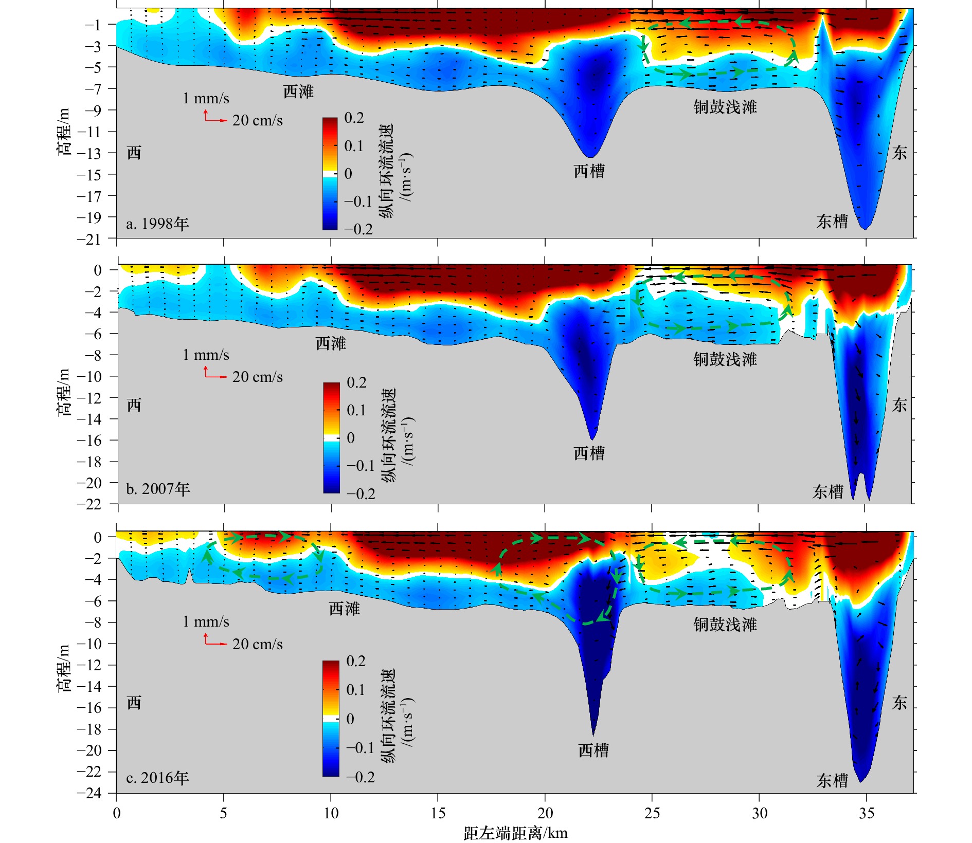
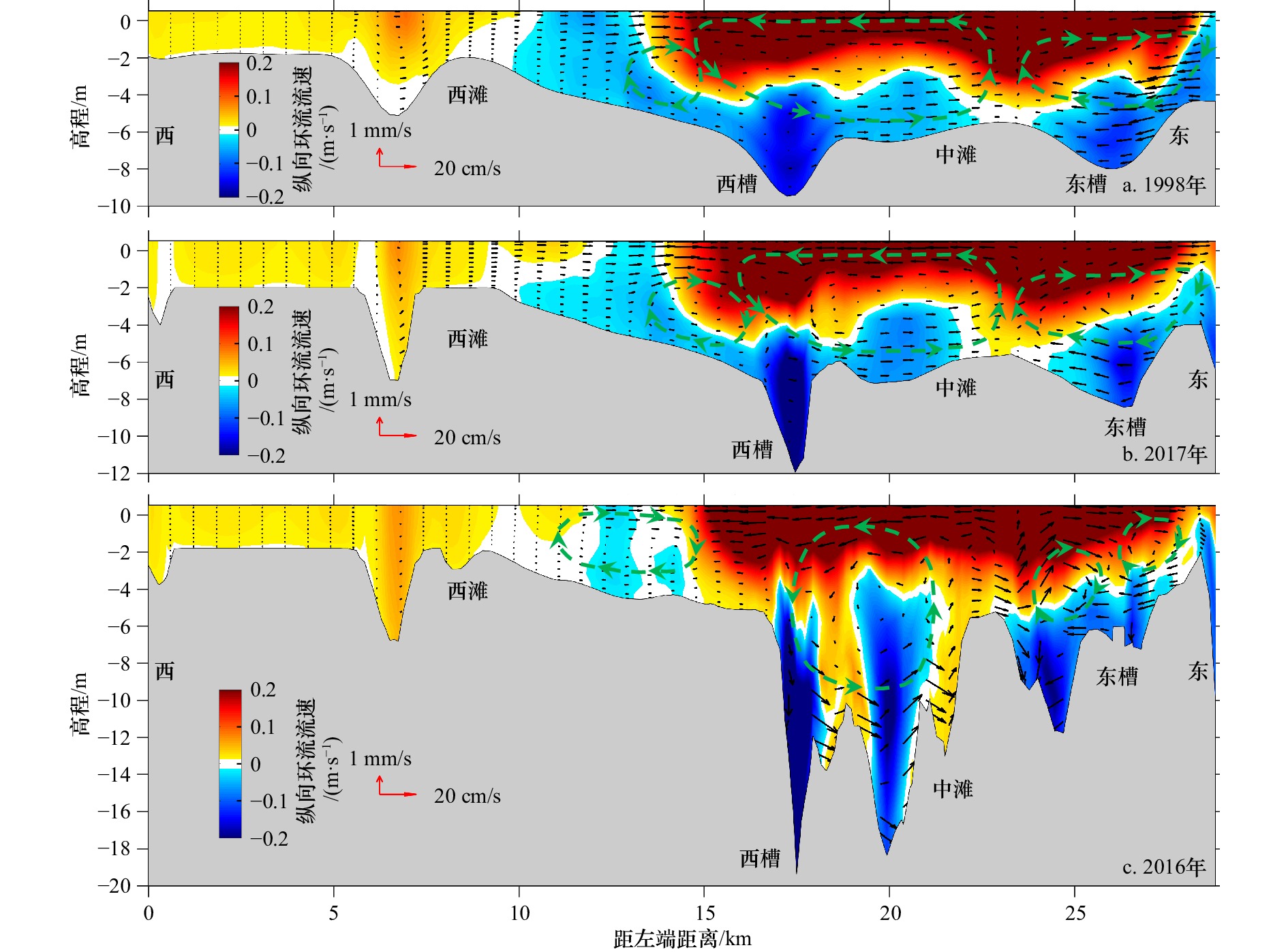
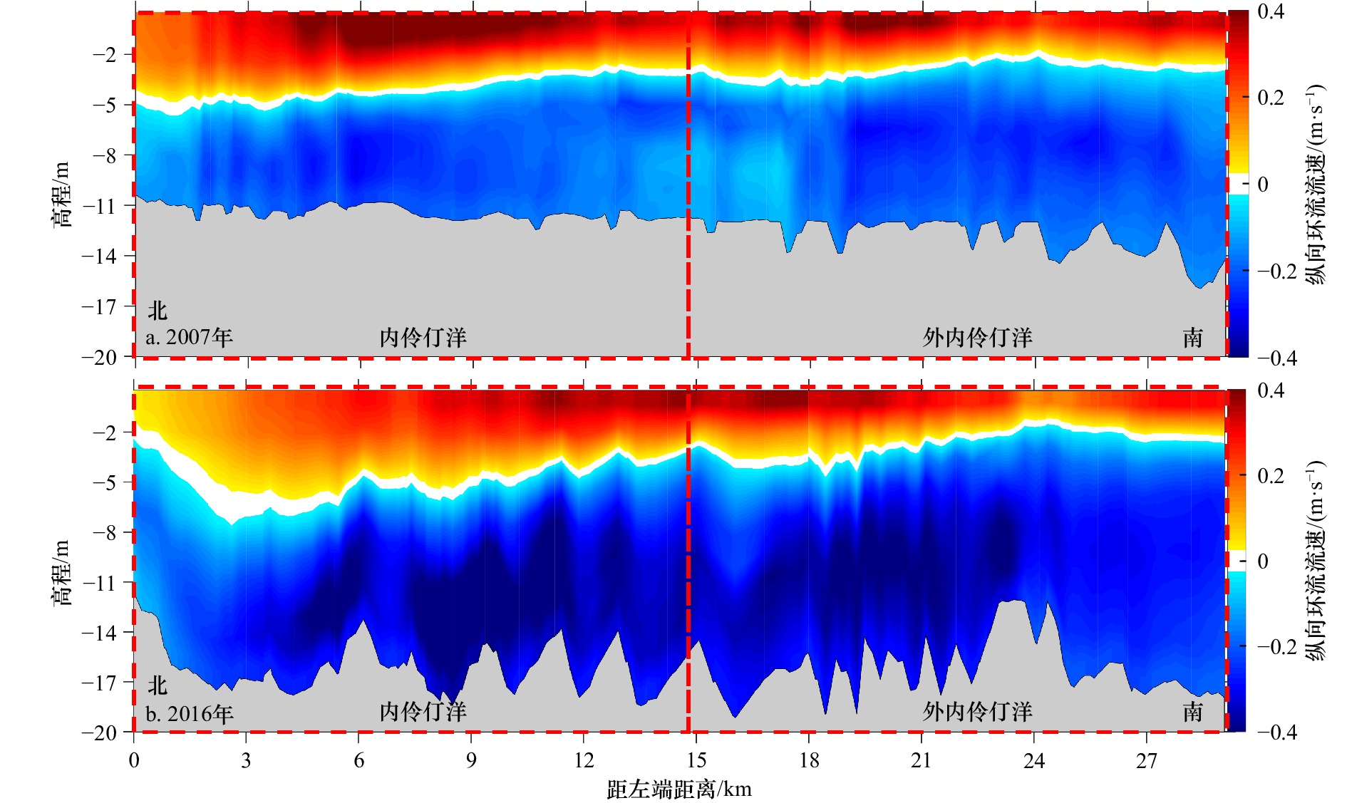
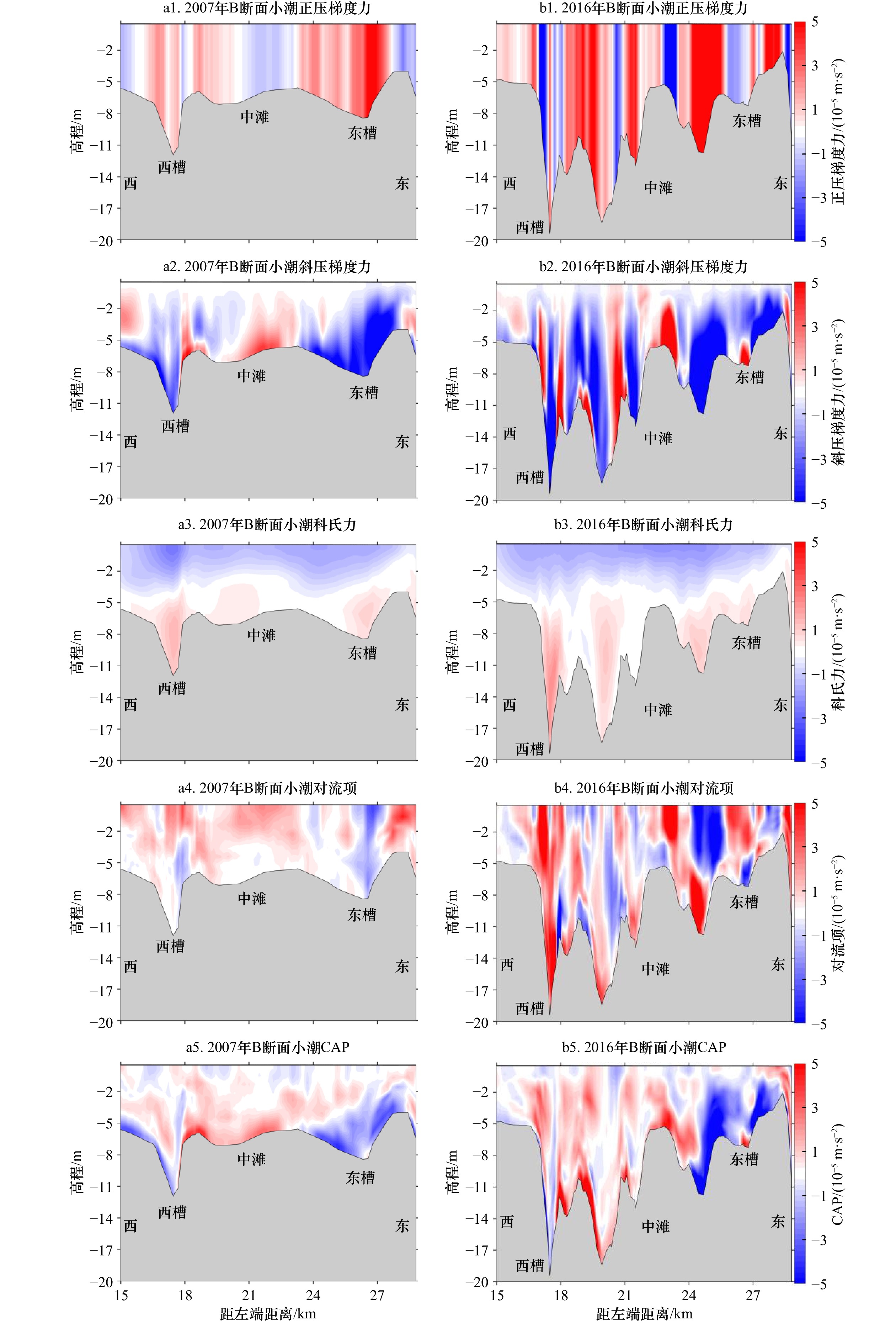
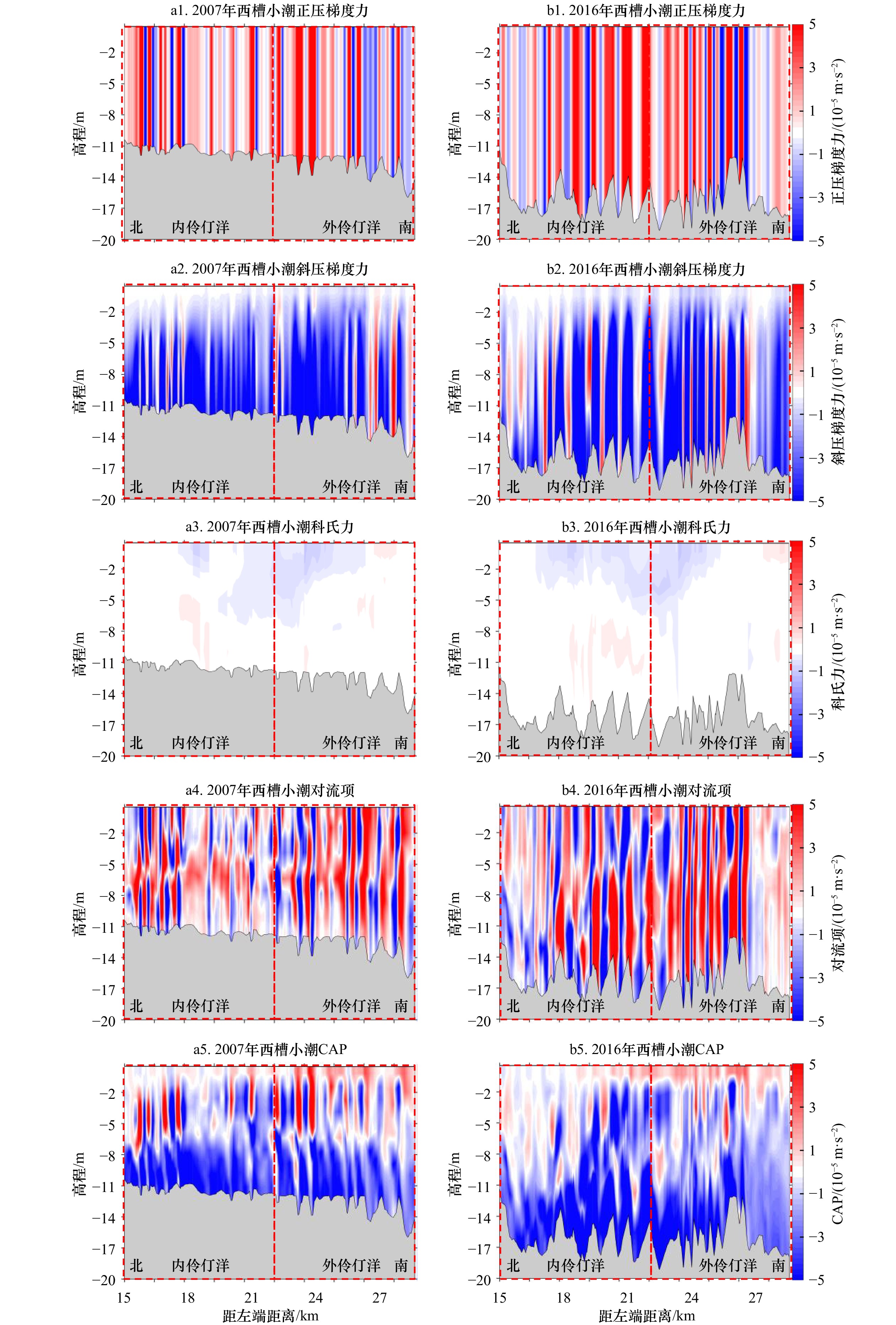
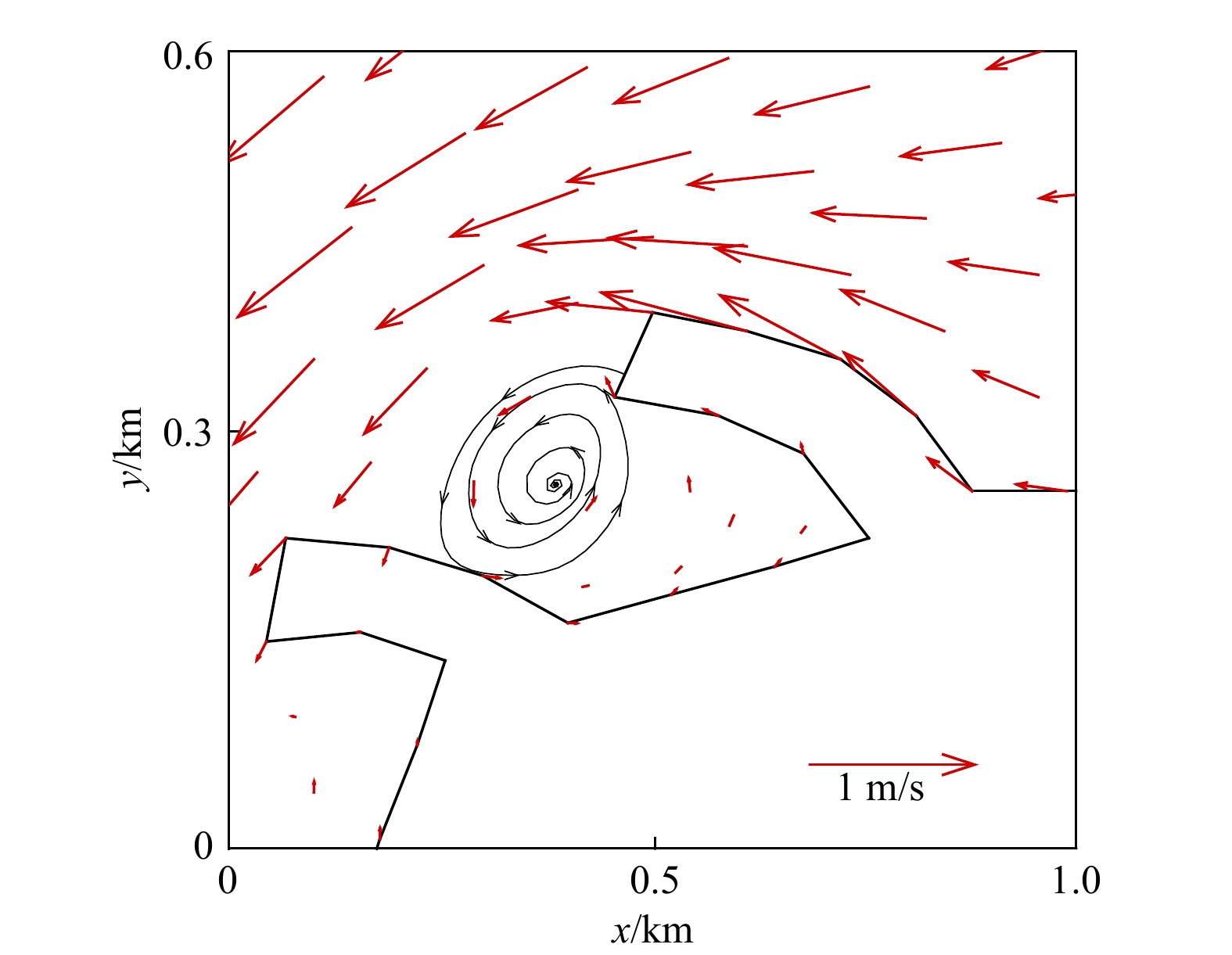
Over the past 20 years, the morphology of the Lingding Bay in the Zhujiang River Estuary has undergone anomalous changes, which is far beyond natural processes due to the influence of high intensity human activities. Hence, the resulted estuarine dynamics have inevitably influenced as well as the material transport processes. In this study, a three-dimensional model has been setup to explore the changes of residual circulation pattern in the Lingding Bay over the past 20 years and their potential impacts. The results show that the bottom residual flow along the East and West channels is turned towards the Middle Shoal area, which promotes the sedimentation there. The lateral residual circulation in the Middle Shoal depicts a layered structure of the surface to the west and the bottom to the east, mainly driven by the non-linear advection term. The large-scale sand mining in the Middle Shoal has resulted in the eastward shift of the residual circulation structure and the enhancement of the surface and bottom residual currents, which can accelerate the exchange of material between the surface and bottom layers. A longitudinal residual circulation structure exists in the West Channel with the surface layer seaward and the bottom layer landward, driven mainly by barotropic and baroclinic pressure gradient forces. Due to the effect of dredging depth, both the landward baroclinic pressure gradient force and the non-linear convection term are enhanced, the seaward-direction surface residual flow reduces by 22%, while the landward-direction bottom residual flow increases by 24%, which will weaken the exchange capacity of the water body in the western trough during the neap tide period, i.e. slow down the material export, resulting in the siltation of the western trough and the weakening of the water environment. This study can provide implications for understanding of estuarine residual circulation as well as material transport under anthropogenic disturbance.
Over the past 20 years, the morphology of the Lingding Bay in the Zhujiang River Estuary has undergone anomalous changes, which is far beyond natural processes due to the influence of high intensity human activities. Hence, the resulted estuarine dynamics have inevitably influenced as well as the material transport processes. In this study, a three-dimensional model has been setup to explore the changes of residual circulation pattern in the Lingding Bay over the past 20 years and their potential impacts. The results show that the bottom residual flow along the East and West channels is turned towards the Middle Shoal area, which promotes the sedimentation there. The lateral residual circulation in the Middle Shoal depicts a layered structure of the surface to the west and the bottom to the east, mainly driven by the non-linear advection term. The large-scale sand mining in the Middle Shoal has resulted in the eastward shift of the residual circulation structure and the enhancement of the surface and bottom residual currents, which can accelerate the exchange of material between the surface and bottom layers. A longitudinal residual circulation structure exists in the West Channel with the surface layer seaward and the bottom layer landward, driven mainly by barotropic and baroclinic pressure gradient forces. Due to the effect of dredging depth, both the landward baroclinic pressure gradient force and the non-linear convection term are enhanced, the seaward-direction surface residual flow reduces by 22%, while the landward-direction bottom residual flow increases by 24%, which will weaken the exchange capacity of the water body in the western trough during the neap tide period, i.e. slow down the material export, resulting in the siltation of the western trough and the weakening of the water environment. This study can provide implications for understanding of estuarine residual circulation as well as material transport under anthropogenic disturbance.


2023, 45(2): 42-50.
doi: 10.12284/hyxb2023011
Abstract:
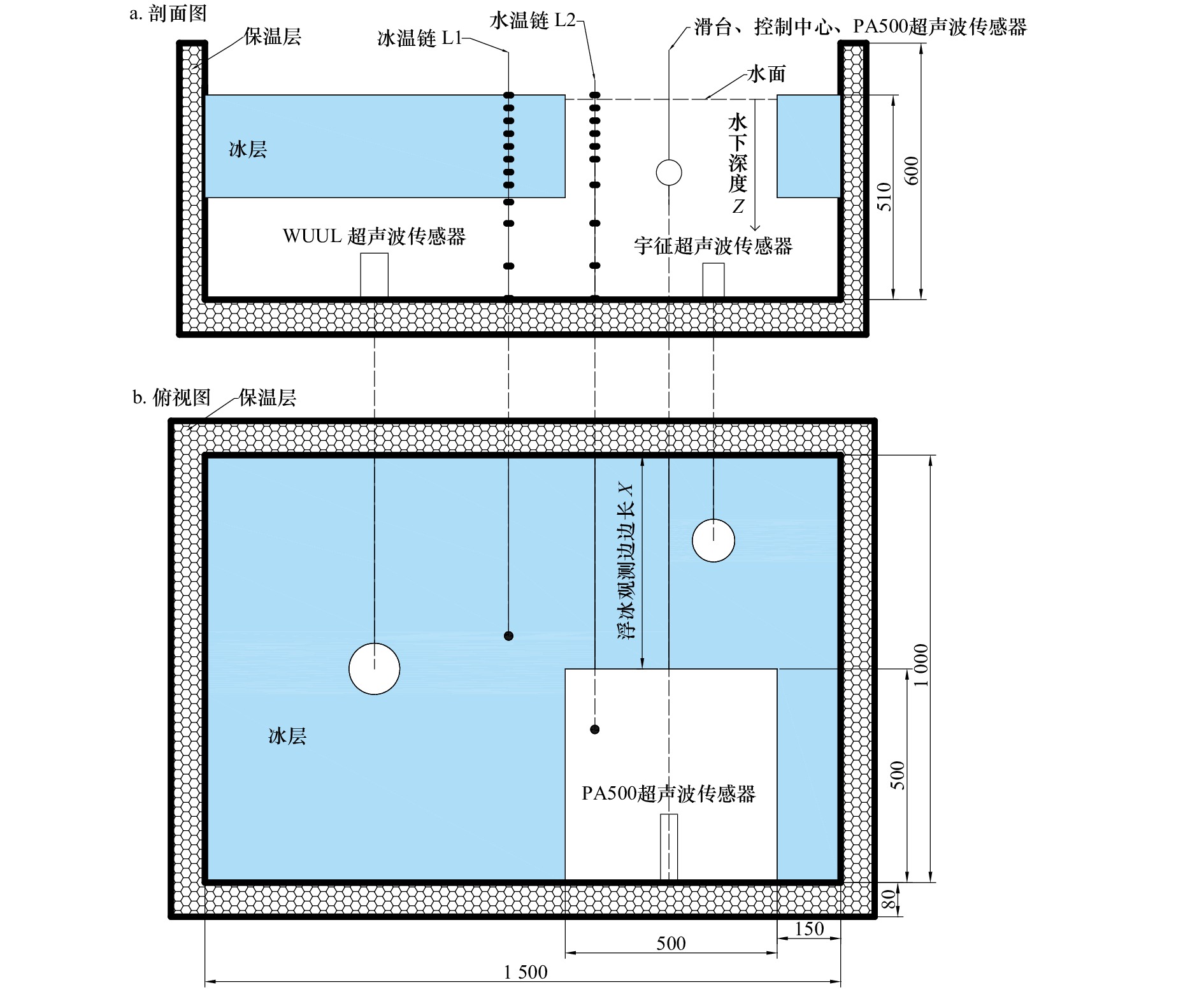
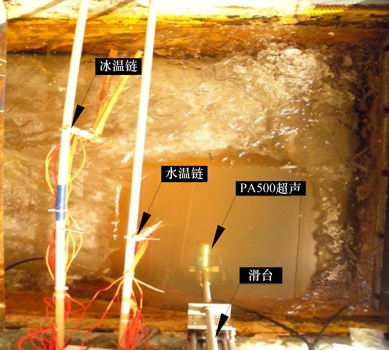
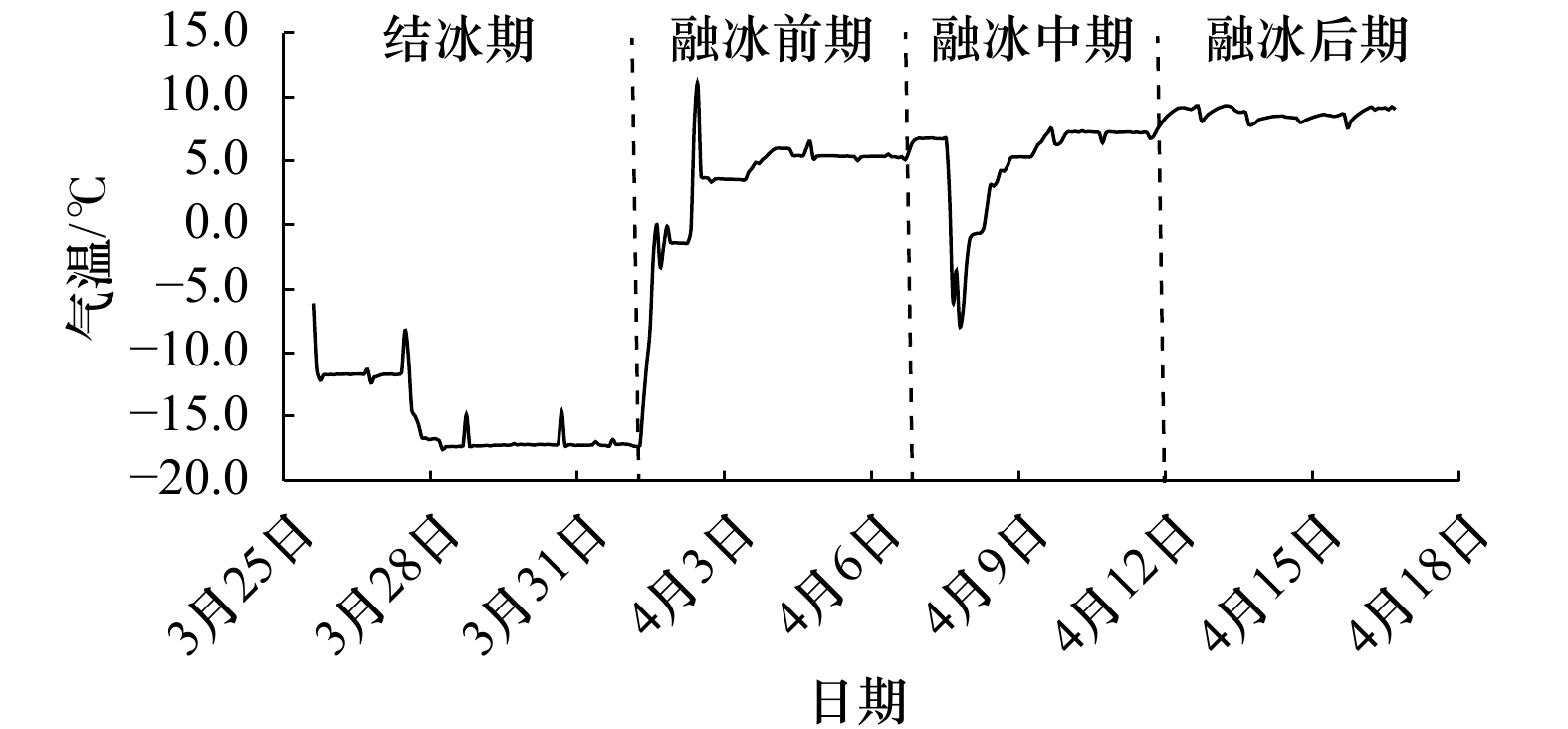
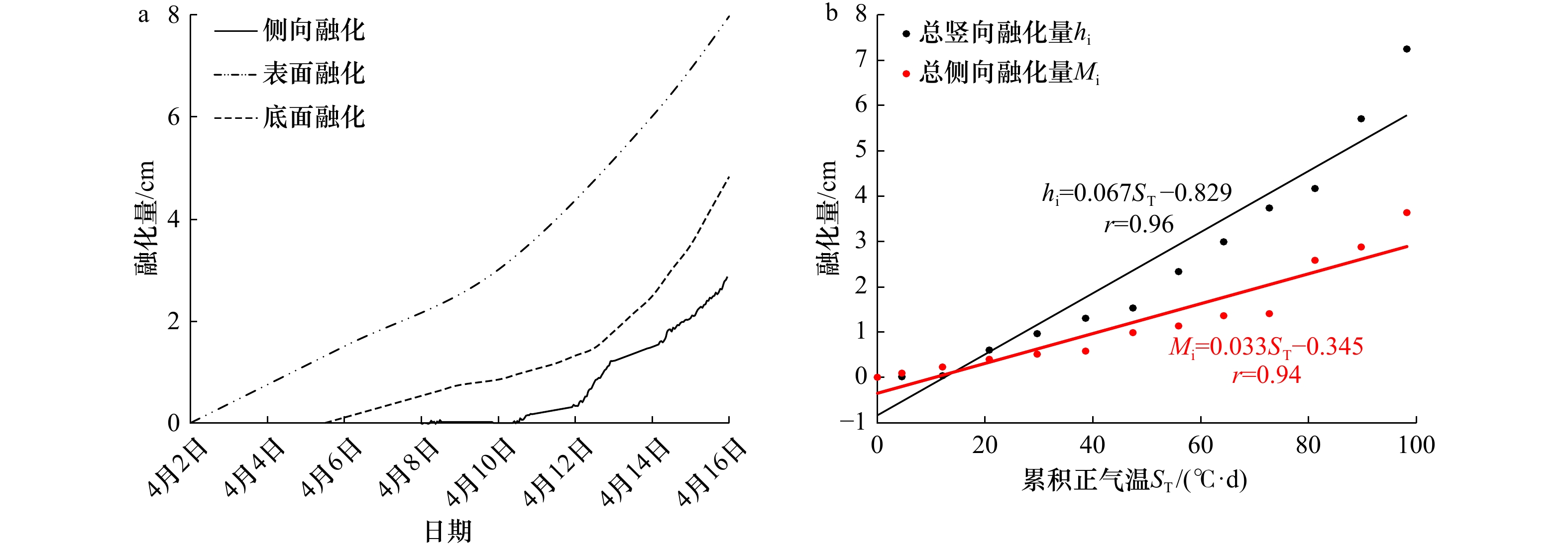
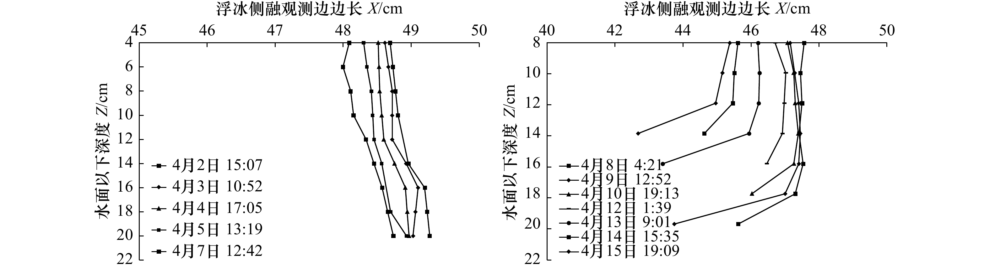
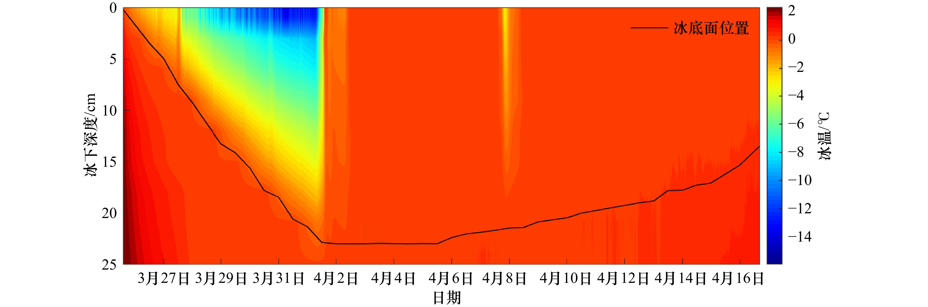
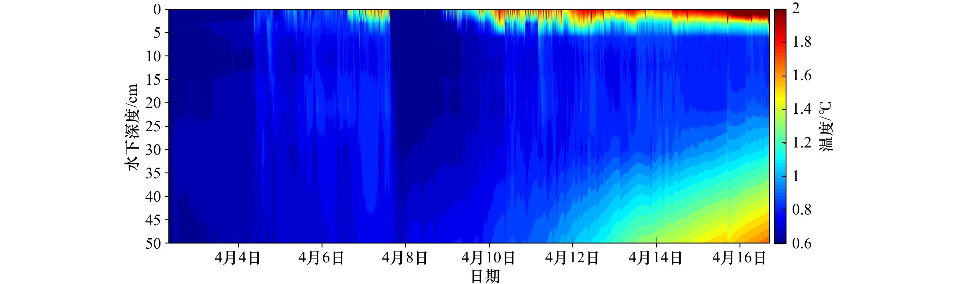
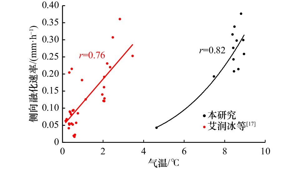
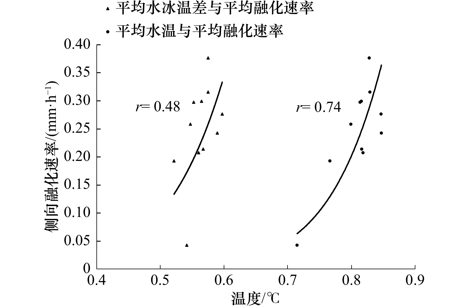
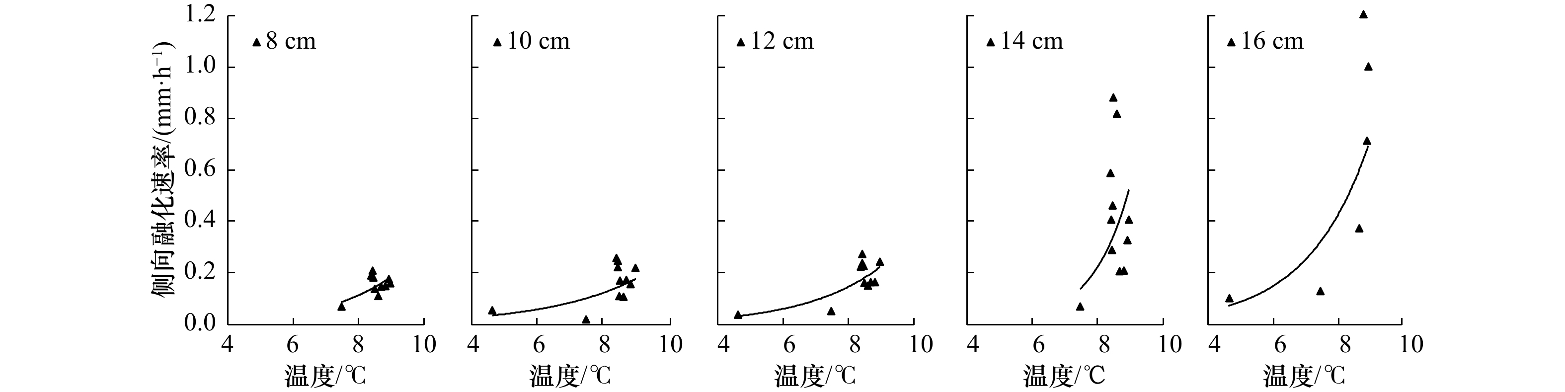
In order to investigate the melting process at the ice-water lateral interface and to quantify the dominant factors affecting the lateral melting rate of ice layer, an ice melting experiment was carried out in a low-temperature water tank. Simultaneous measurements of the ice bottom and surface processes and the lateral melting process of the ice layer were carried out, while the laboratory air temperature, ice temperature at different depths inside the ice samples and water temperature at different depths in open water were recorded, the relationships between different elements and their influence patterns on the lateral melting rate of ice were investigated using correlation analysis methods. The results show that the lateral melting rate at different depths inside the ice samples was slow and uniform in the early stage of melting, with an average melting rate of 0.05 mm/h. The lateral melting rate at different depths in the middle and late stages of melting increased significantly and was no longer uniform, with an average melting rate of 0.15 mm/h. The correlation coefficient of the average lateral melting rate and air temperature (r=0.82) was better than that between the average water temperature (r=0.74) and the water-ice temperature difference (r=0.48). The quantitative relationships of lateral melting rate with temperature (air temperature, water temperature) and depth were established to accurately describe the non-uniformity of the lateral melting process of ice layer. It also verifies the feasibility of conducting non-uniform lateral melting test techniques, and lays the foundation for sea ice tests that more closely resemble real Arctic conditions considering wind speed and light source conditions.
In order to investigate the melting process at the ice-water lateral interface and to quantify the dominant factors affecting the lateral melting rate of ice layer, an ice melting experiment was carried out in a low-temperature water tank. Simultaneous measurements of the ice bottom and surface processes and the lateral melting process of the ice layer were carried out, while the laboratory air temperature, ice temperature at different depths inside the ice samples and water temperature at different depths in open water were recorded, the relationships between different elements and their influence patterns on the lateral melting rate of ice were investigated using correlation analysis methods. The results show that the lateral melting rate at different depths inside the ice samples was slow and uniform in the early stage of melting, with an average melting rate of 0.05 mm/h. The lateral melting rate at different depths in the middle and late stages of melting increased significantly and was no longer uniform, with an average melting rate of 0.15 mm/h. The correlation coefficient of the average lateral melting rate and air temperature (r=0.82) was better than that between the average water temperature (r=0.74) and the water-ice temperature difference (r=0.48). The quantitative relationships of lateral melting rate with temperature (air temperature, water temperature) and depth were established to accurately describe the non-uniformity of the lateral melting process of ice layer. It also verifies the feasibility of conducting non-uniform lateral melting test techniques, and lays the foundation for sea ice tests that more closely resemble real Arctic conditions considering wind speed and light source conditions.

2023, 45(2): 51-61.
doi: 10.12284/hyxb2023029
Abstract:
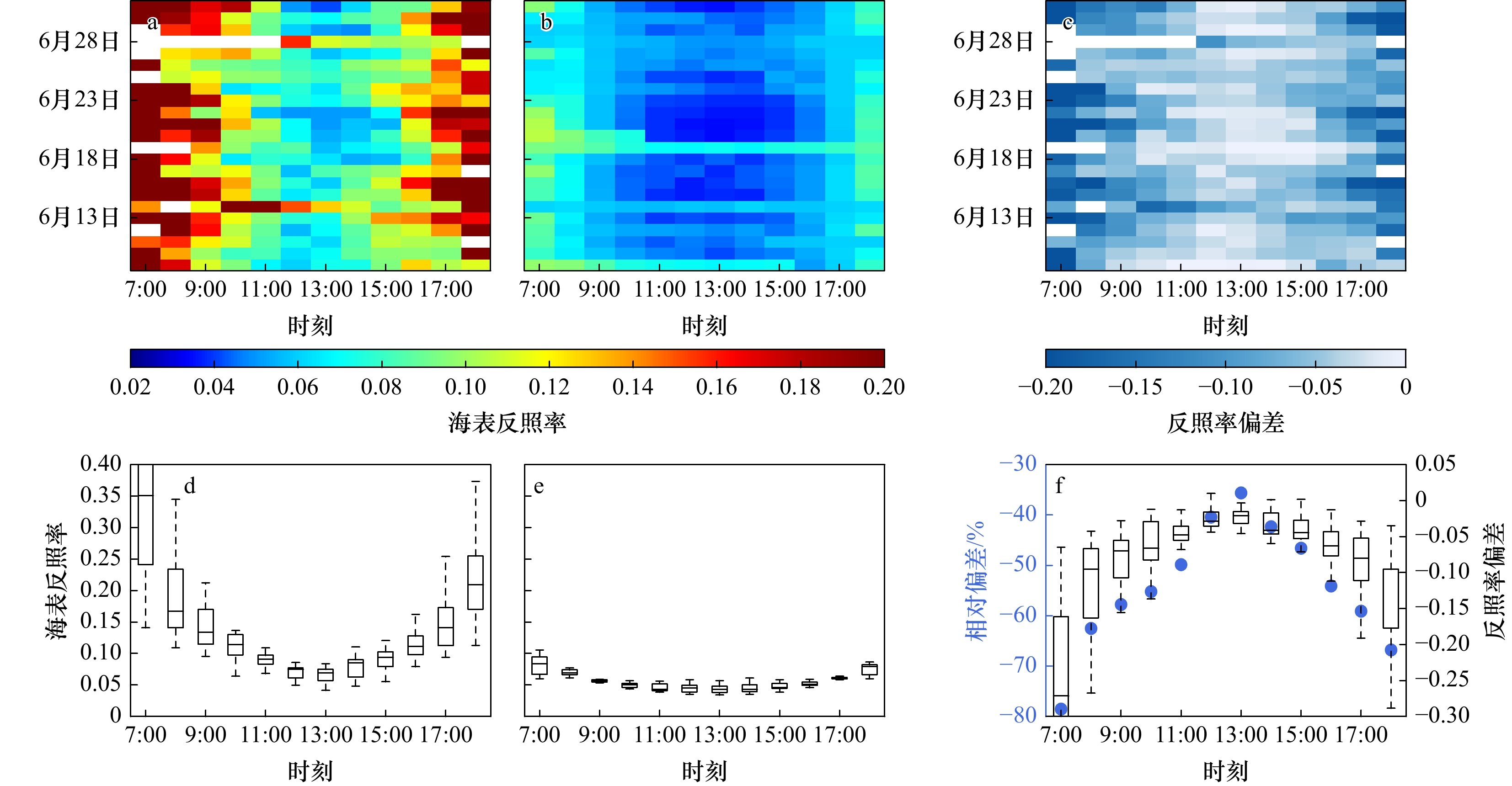
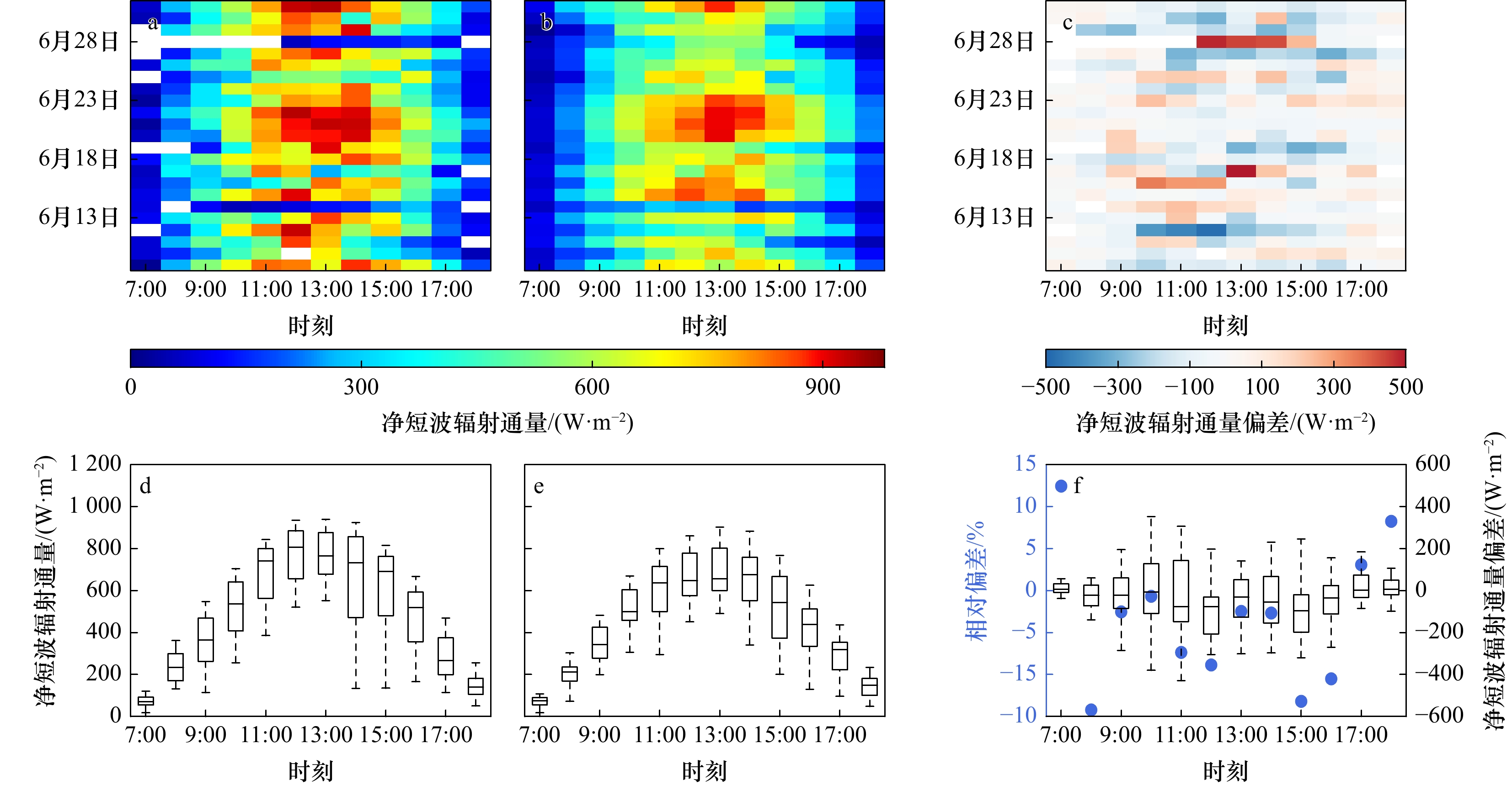
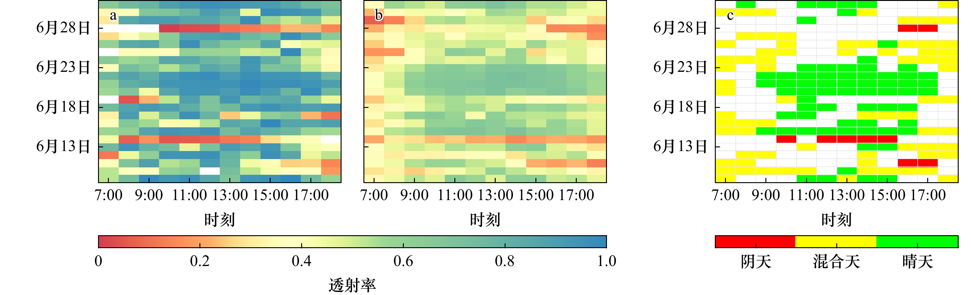
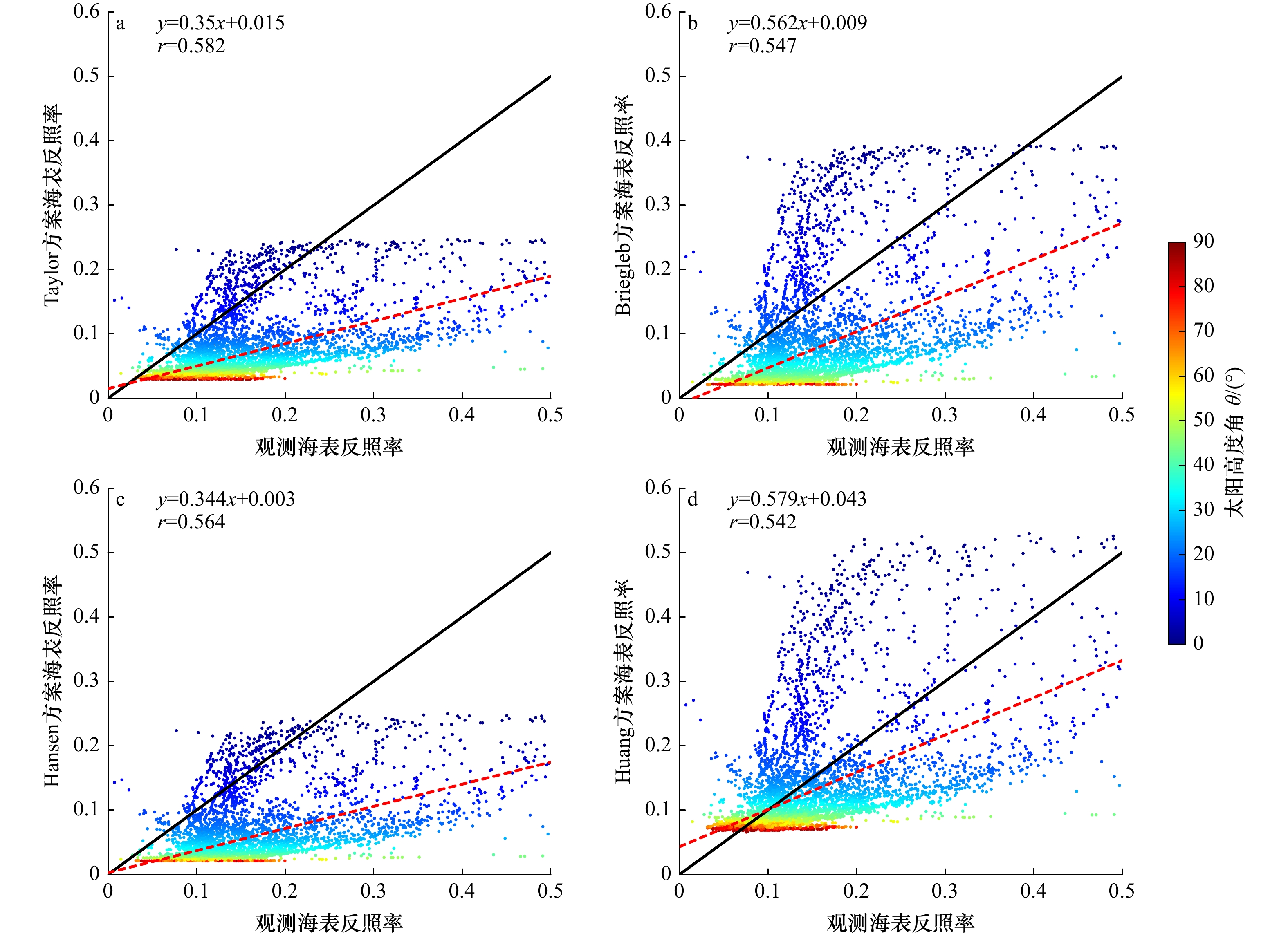
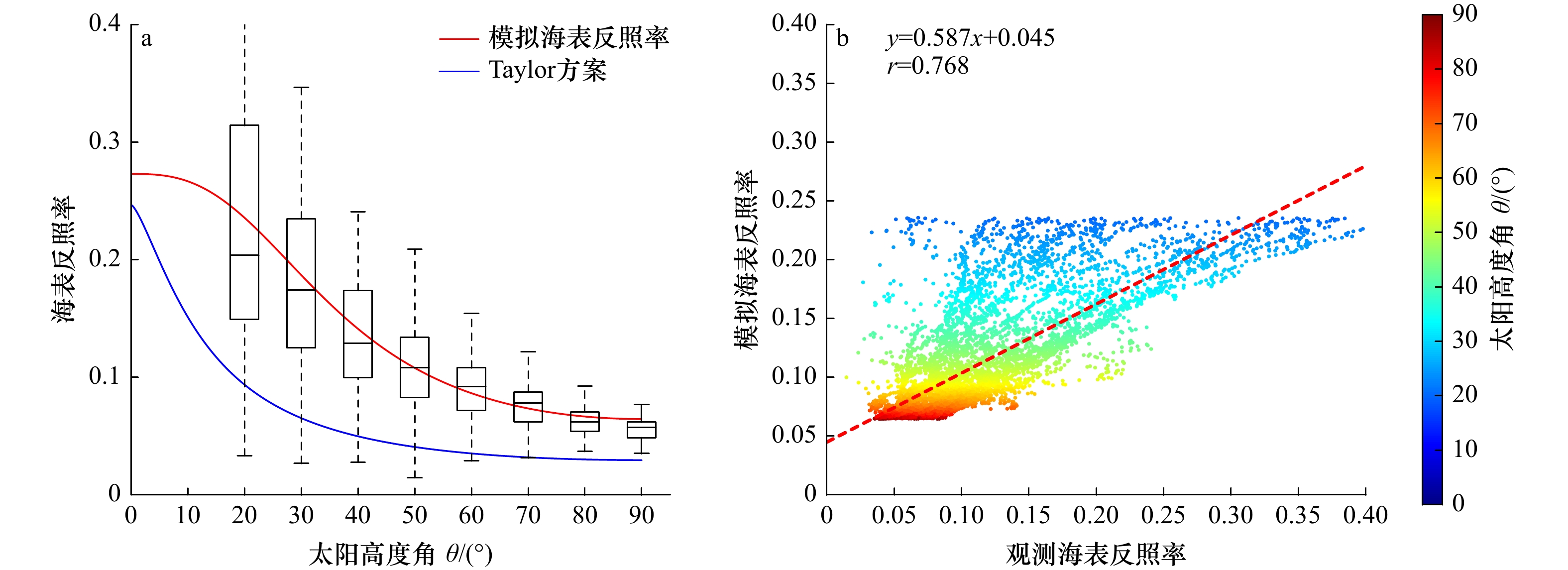
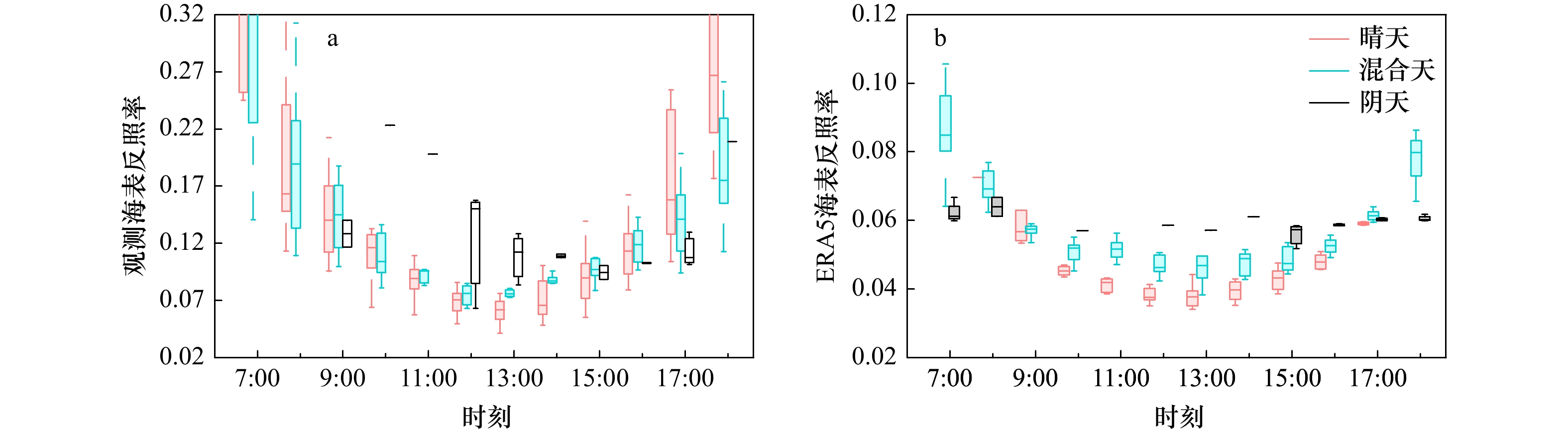
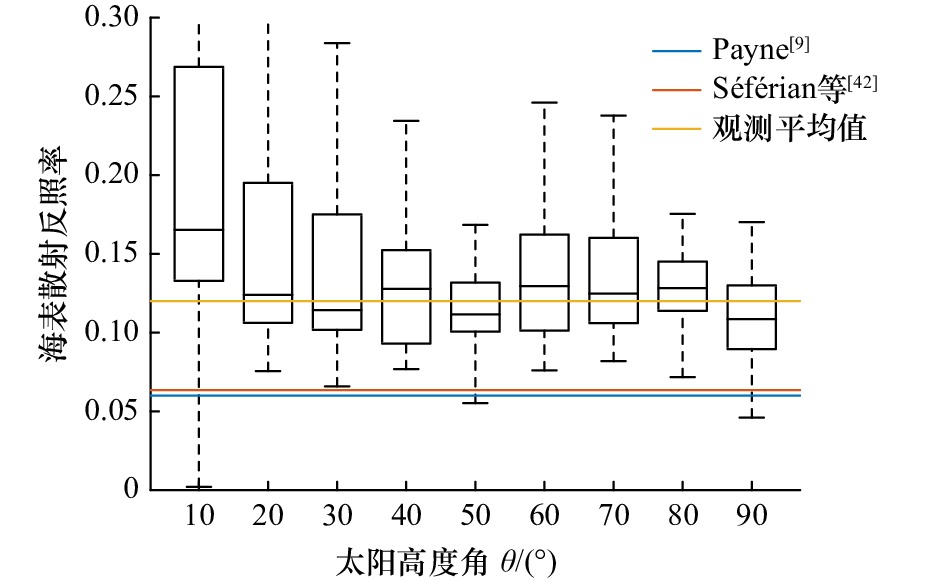
The short wave radiation budget on the sea surface is an important physical process of energy exchange at the sea-air interface. In this study, the sea surface short wave radiation flux budget of ERA5 reanalysis data is evaluated by using the observed data of summer scientific research voyages in the northern South China Sea in 2019. The results show that the downward short wave radiation of ERA5 is smaller than the observed data, and the deviation is the largest at 11:00 and 15:00 (Beijing time), up to −100 W/m2. At the same time, the sea surface albedo of ERA5 is generally lower than observed. The bias in ERA5 is small under a high solar altitude angle, being about −0.03, but can reach −0.15 under a low solar altitude. The bias in the downward shortwave radiation and sea surface albedo jointly caused an underestimation of 25.4 W/m2 in the daytime average sea surface net shortwave radiation flux in ERA5. In particular, the albedo underestimation offsets about 50% of the contribution of downward shortwave radiation bias. The results show that ERA5 has different manifestations of sea surface radiation budget deviation under different atmospheric transmittance conditions. We also found that the underestimation of sea surface albedo in ERA5 is caused by its parameterization schemes and put an optimization based on our observation.
The short wave radiation budget on the sea surface is an important physical process of energy exchange at the sea-air interface. In this study, the sea surface short wave radiation flux budget of ERA5 reanalysis data is evaluated by using the observed data of summer scientific research voyages in the northern South China Sea in 2019. The results show that the downward short wave radiation of ERA5 is smaller than the observed data, and the deviation is the largest at 11:00 and 15:00 (Beijing time), up to −100 W/m2. At the same time, the sea surface albedo of ERA5 is generally lower than observed. The bias in ERA5 is small under a high solar altitude angle, being about −0.03, but can reach −0.15 under a low solar altitude. The bias in the downward shortwave radiation and sea surface albedo jointly caused an underestimation of 25.4 W/m2 in the daytime average sea surface net shortwave radiation flux in ERA5. In particular, the albedo underestimation offsets about 50% of the contribution of downward shortwave radiation bias. The results show that ERA5 has different manifestations of sea surface radiation budget deviation under different atmospheric transmittance conditions. We also found that the underestimation of sea surface albedo in ERA5 is caused by its parameterization schemes and put an optimization based on our observation.

2023, 45(2): 139-150.
doi: 10.12284/hyxb2023003
Abstract:
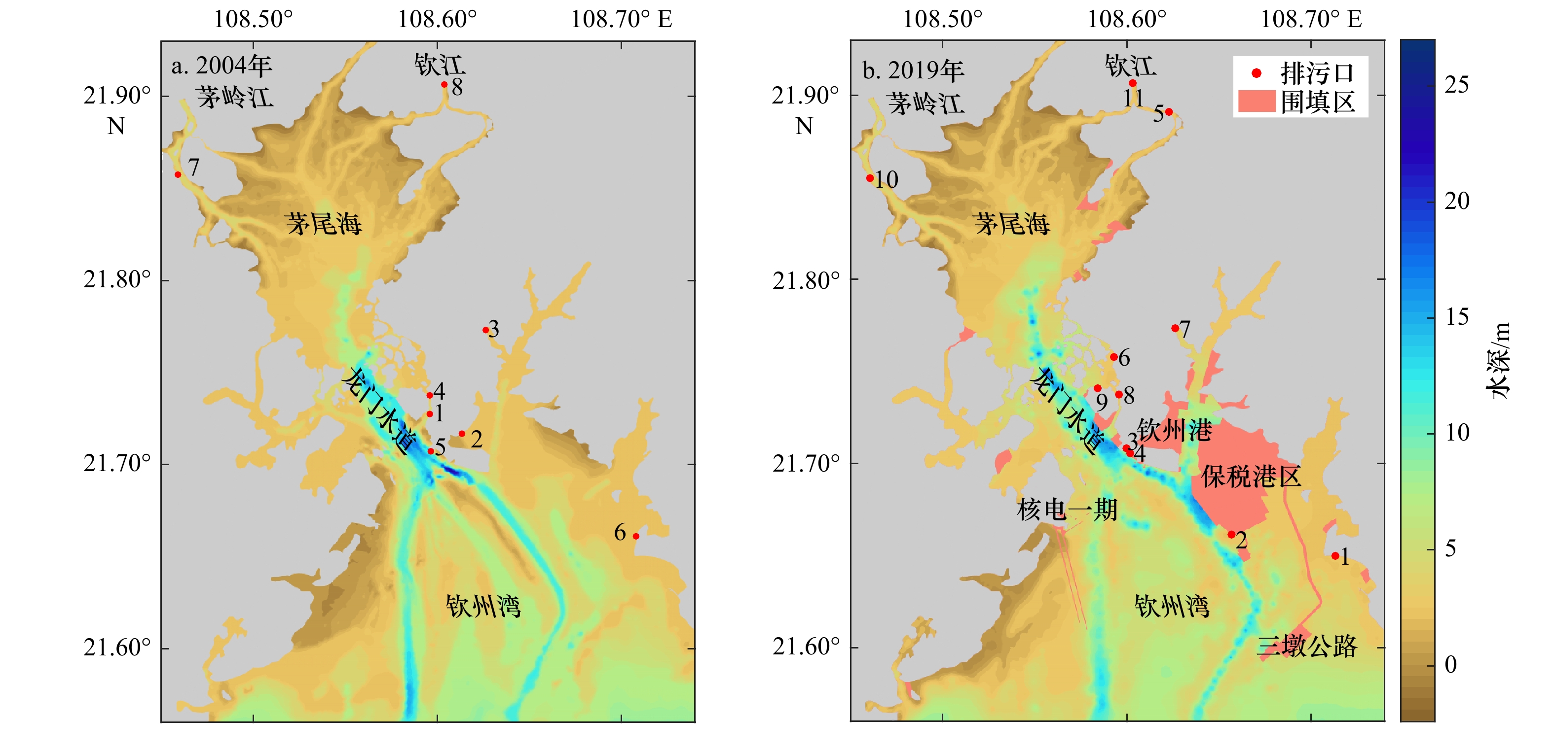
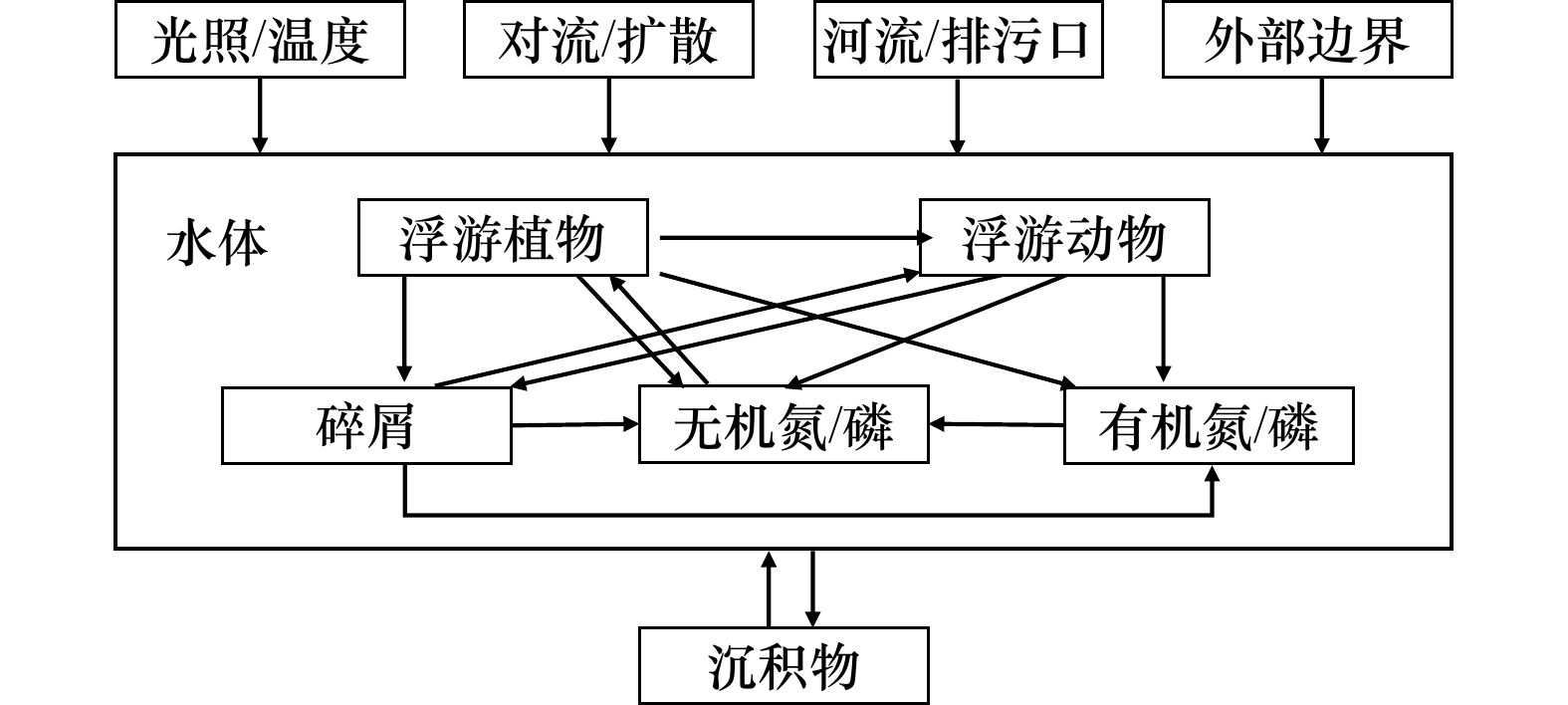
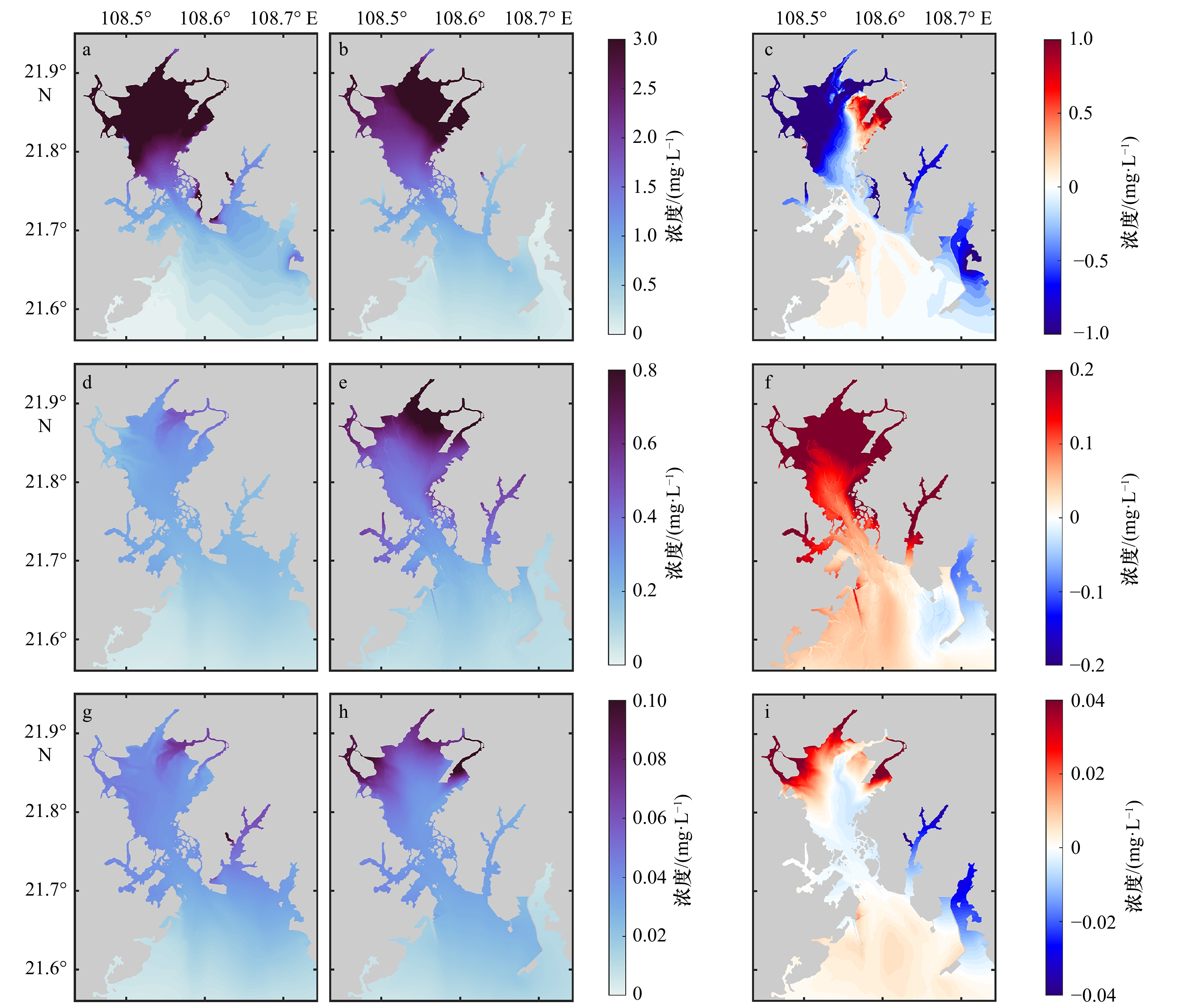
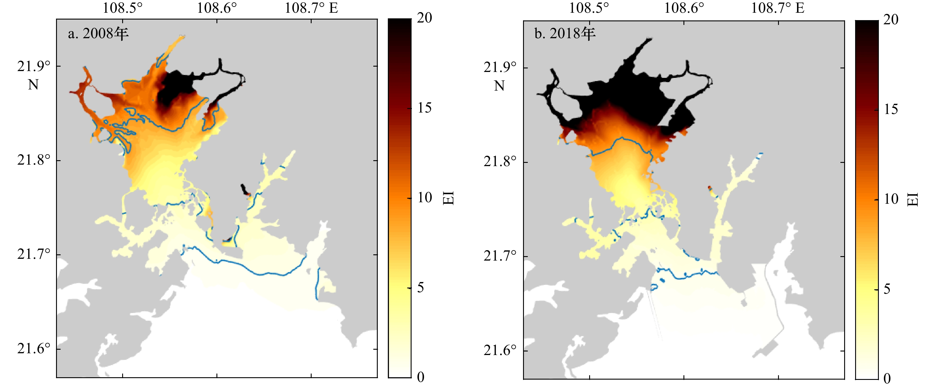
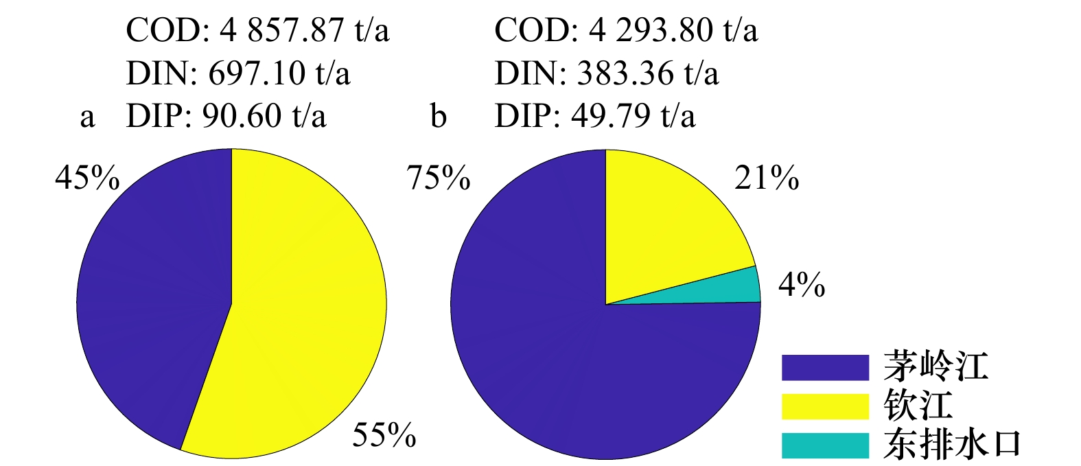
From 2004 to 2019, human activities have caused a profound and irreversible impact on Qinzhou Bay (QZB) through large-scale land reclamation and land-based sewage discharge. In this study, based on the satellite images and marine charts, a hydro-biogeochemical model was established to analyze the cumulative effect of human activities on water quality in Qinzhou Bay during the past decades. Under the double anthropogenic pressures, the concentration of chemical oxygen demand (COD) in QZB has slightly decreased from 0.976 mg/L to 0.909 mg/L. But the concentration of inorganic nitrogen (DIN) and inorganic phosphorus (DIP) increased obviously from 0.146 mg/L and 0.023 mg/L to 0.230 mg/L and 0.027 mg/L, respectively. The statistical results show that the area of heavily polluted and severe eutrophication water has increased dramatically, indicating the water quality in QZB being degenerated. According to the characteristics of pollution discharge in the bay, the share rate method was used to calculate the environment capacity in different scenarios. The results show that the actual emissions far exceed the maximum allowed amount in the bay, particularly in Maoling River and Qinjiang River, where the emissions of pollutants need to be reduced urgently. Because of the decrease of the water area and water exchange capacity caused by land reclamation, the environment capacity has reduced compare to the historical situation. The calculation of sewage discharge optimization method for Maowei Sea indicates that Maoling River should share more sewage discharge than Qinjiang River, which is conducive to the improvement of water quality in Maowei Sea. It is estimated that the environmental capacity value loss of Qinzhou Bay caused by two anthropogenic pressures is approximate 2.695 billion per year, so compensation should be considered before exploitation and utilization of the coastal ocean.
From 2004 to 2019, human activities have caused a profound and irreversible impact on Qinzhou Bay (QZB) through large-scale land reclamation and land-based sewage discharge. In this study, based on the satellite images and marine charts, a hydro-biogeochemical model was established to analyze the cumulative effect of human activities on water quality in Qinzhou Bay during the past decades. Under the double anthropogenic pressures, the concentration of chemical oxygen demand (COD) in QZB has slightly decreased from 0.976 mg/L to 0.909 mg/L. But the concentration of inorganic nitrogen (DIN) and inorganic phosphorus (DIP) increased obviously from 0.146 mg/L and 0.023 mg/L to 0.230 mg/L and 0.027 mg/L, respectively. The statistical results show that the area of heavily polluted and severe eutrophication water has increased dramatically, indicating the water quality in QZB being degenerated. According to the characteristics of pollution discharge in the bay, the share rate method was used to calculate the environment capacity in different scenarios. The results show that the actual emissions far exceed the maximum allowed amount in the bay, particularly in Maoling River and Qinjiang River, where the emissions of pollutants need to be reduced urgently. Because of the decrease of the water area and water exchange capacity caused by land reclamation, the environment capacity has reduced compare to the historical situation. The calculation of sewage discharge optimization method for Maowei Sea indicates that Maoling River should share more sewage discharge than Qinjiang River, which is conducive to the improvement of water quality in Maowei Sea. It is estimated that the environmental capacity value loss of Qinzhou Bay caused by two anthropogenic pressures is approximate 2.695 billion per year, so compensation should be considered before exploitation and utilization of the coastal ocean.

2023, 45(2): 62-73.
doi: 10.12284/hyxb2023017
Abstract:
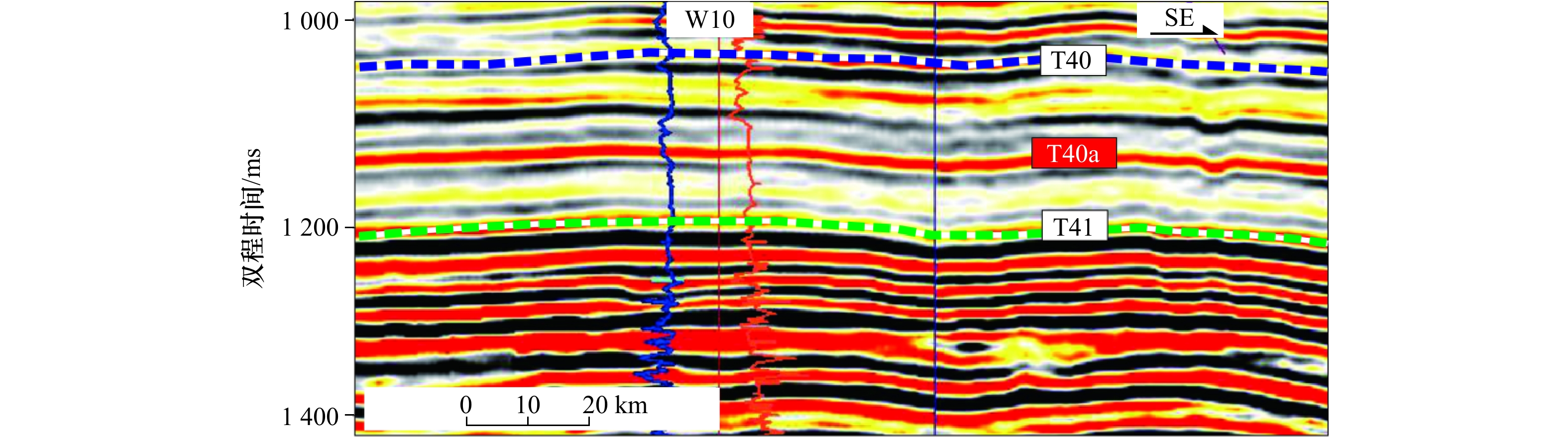
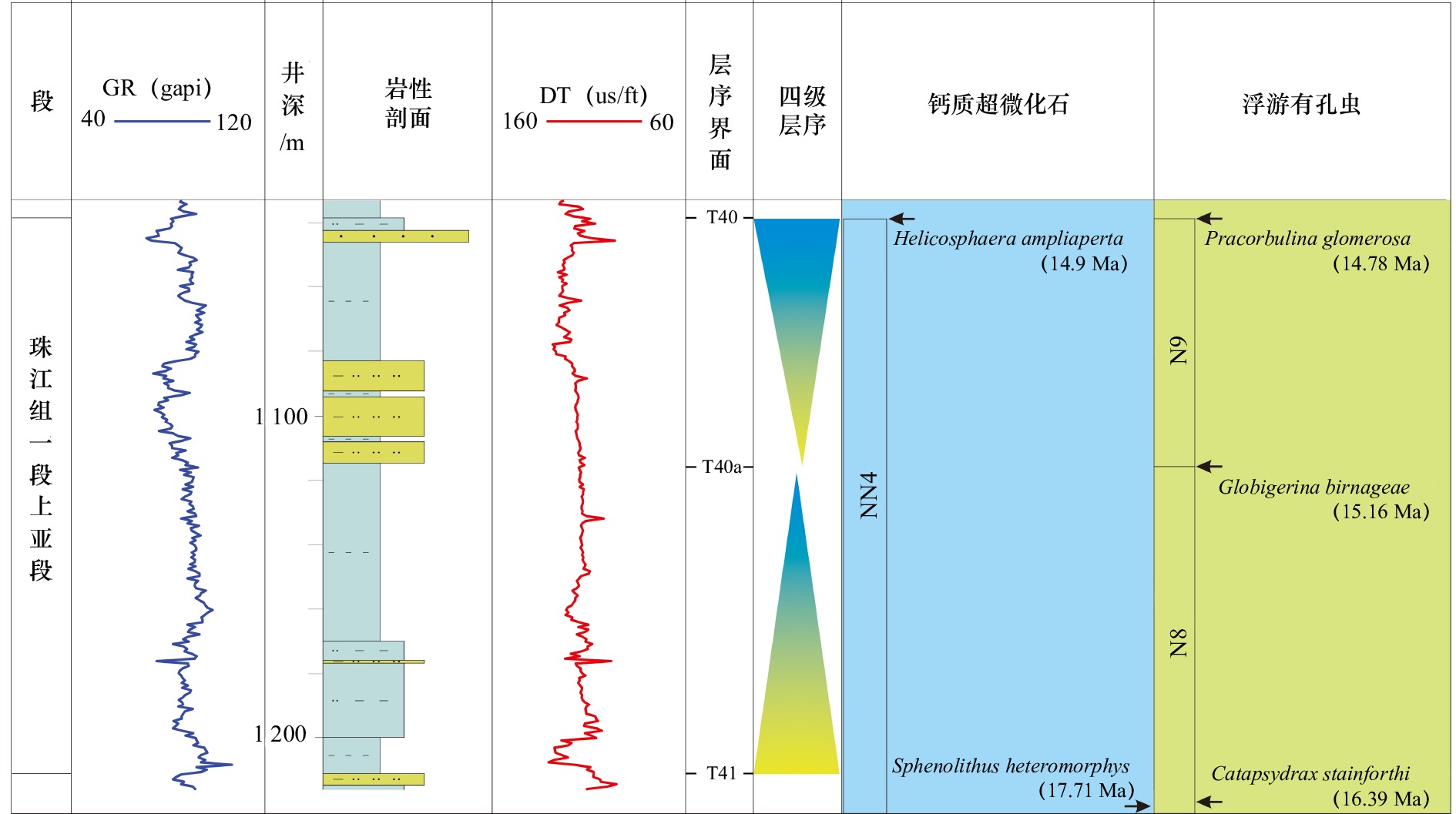
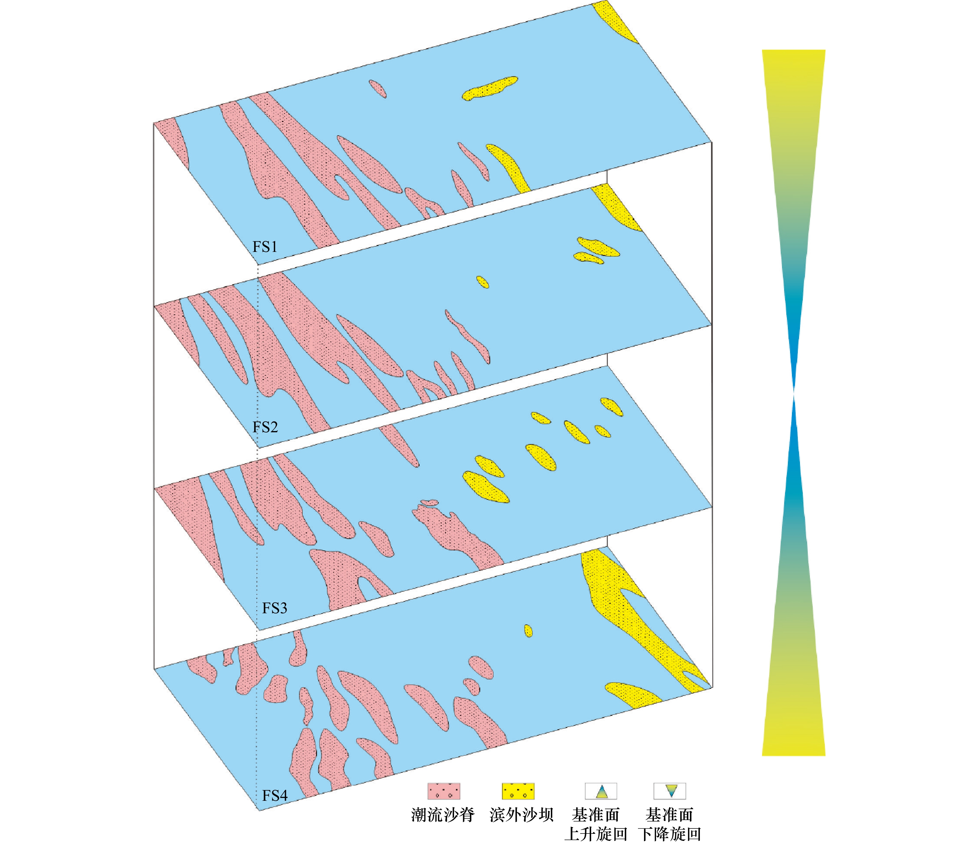
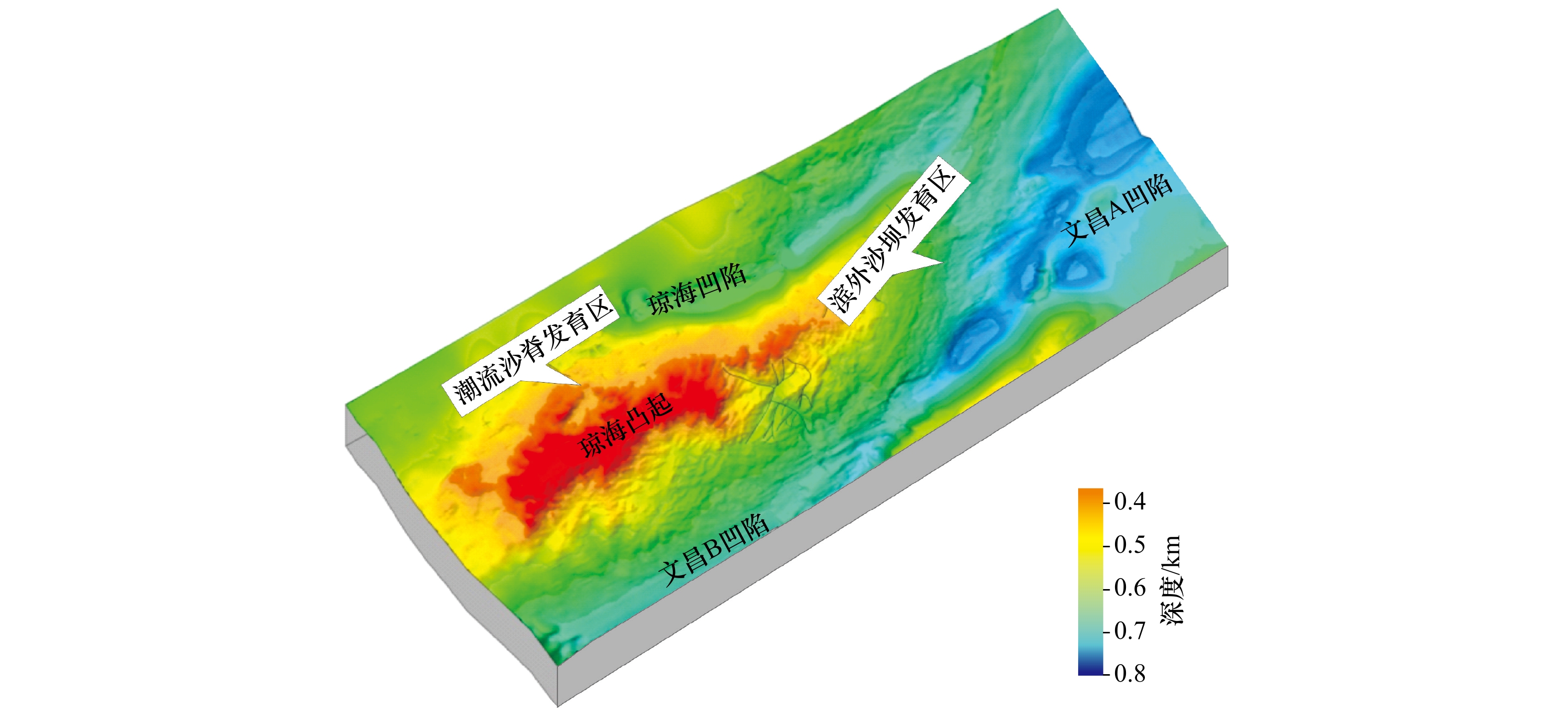
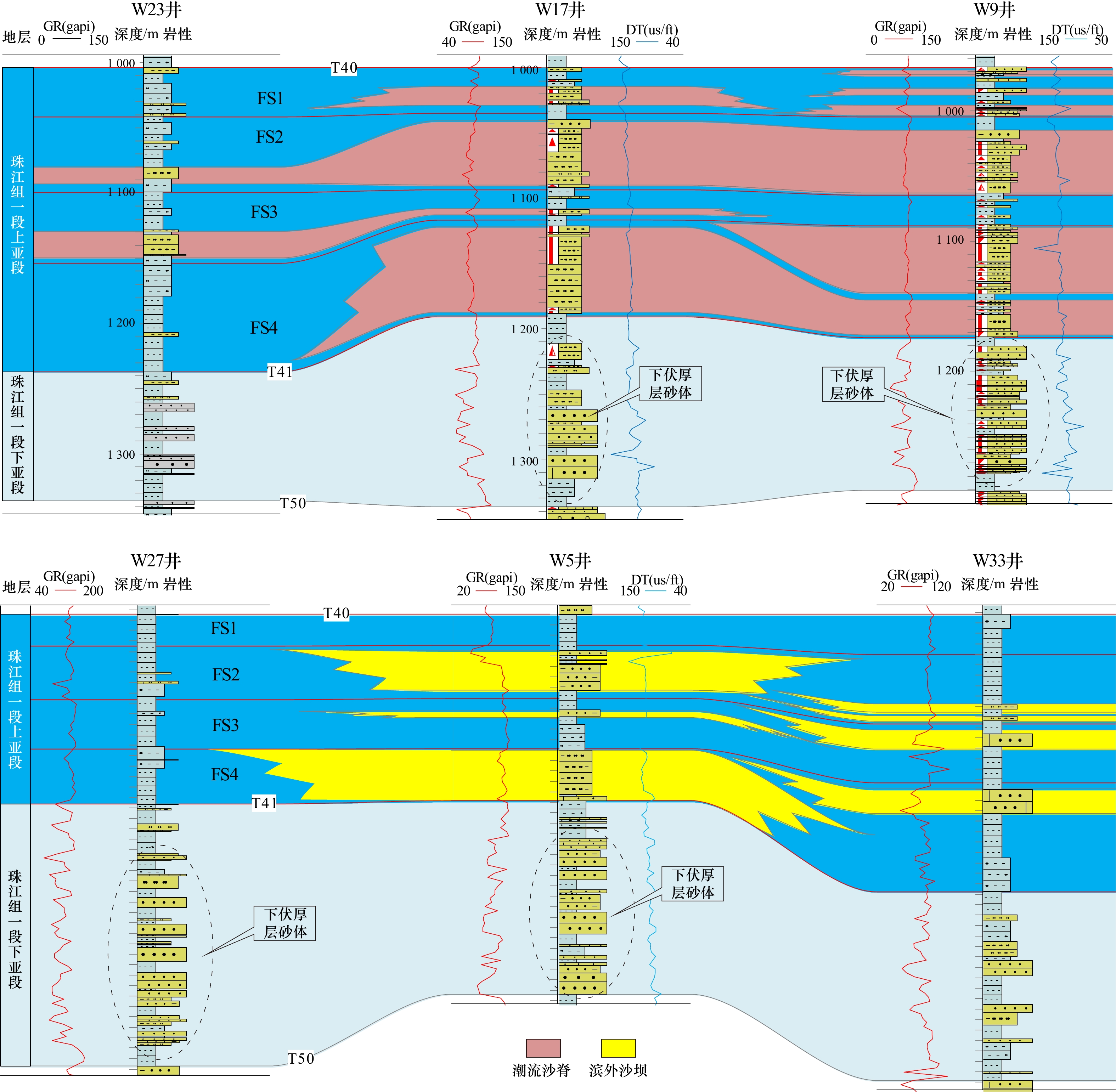
In order to clarify the genetic mechanism of shallow continental shelf sandbodies in the upper submember of the first member of Zhujiang Formation in the northwestern Zhusan Depression, with integrated use of geological and geophysical data, the five-order sequence framework was established firstly, inside of which, the shallow continental shelf sandbodies were identified and quantitatively described, and the temporal and spatial evolution of the shallow continental shelf sandbodies were analyzed, and the genetic mechanism was discussed. The results show that: (1) The upper submember of the first member of Zhujiang Formation in the study area can be divided into four five-order sequences, which were numbered as FS4, FS3, FS2 and FS1 from bottom to top. (2) There are two types of shelf sand bodies: tidal sand ridge and offshore sand bar, which are distributed in NW−SE direction. Tidal sand ridges are mainly distributed in the west of the study area, while offshore sand bars are concentrated in the east. (3) In the three five-order sequences FS4, FS3 and FS2, the scale and quantity of both tidal sand rdiges and offshore sand bars are relatively large, while in the upper five-order sequence FS1, the scale and quantity present poor. (4) Sedimentary base level (hydrodynamic condition), synsedimentary geomorphology and sediment debris supply jointly affected the development scale, distribution characteristics and temporal and spatial evolution of tidal sand ridges and offshore sand bars, which comprehensively constituted the genetic mechanism of shallow continental shelf sand bodies in the northwestern Zhusan Depression.
In order to clarify the genetic mechanism of shallow continental shelf sandbodies in the upper submember of the first member of Zhujiang Formation in the northwestern Zhusan Depression, with integrated use of geological and geophysical data, the five-order sequence framework was established firstly, inside of which, the shallow continental shelf sandbodies were identified and quantitatively described, and the temporal and spatial evolution of the shallow continental shelf sandbodies were analyzed, and the genetic mechanism was discussed. The results show that: (1) The upper submember of the first member of Zhujiang Formation in the study area can be divided into four five-order sequences, which were numbered as FS4, FS3, FS2 and FS1 from bottom to top. (2) There are two types of shelf sand bodies: tidal sand ridge and offshore sand bar, which are distributed in NW−SE direction. Tidal sand ridges are mainly distributed in the west of the study area, while offshore sand bars are concentrated in the east. (3) In the three five-order sequences FS4, FS3 and FS2, the scale and quantity of both tidal sand rdiges and offshore sand bars are relatively large, while in the upper five-order sequence FS1, the scale and quantity present poor. (4) Sedimentary base level (hydrodynamic condition), synsedimentary geomorphology and sediment debris supply jointly affected the development scale, distribution characteristics and temporal and spatial evolution of tidal sand ridges and offshore sand bars, which comprehensively constituted the genetic mechanism of shallow continental shelf sand bodies in the northwestern Zhusan Depression.


2023, 45(2): 74-84.
doi: 10.12284/hyxb2023021
Abstract:
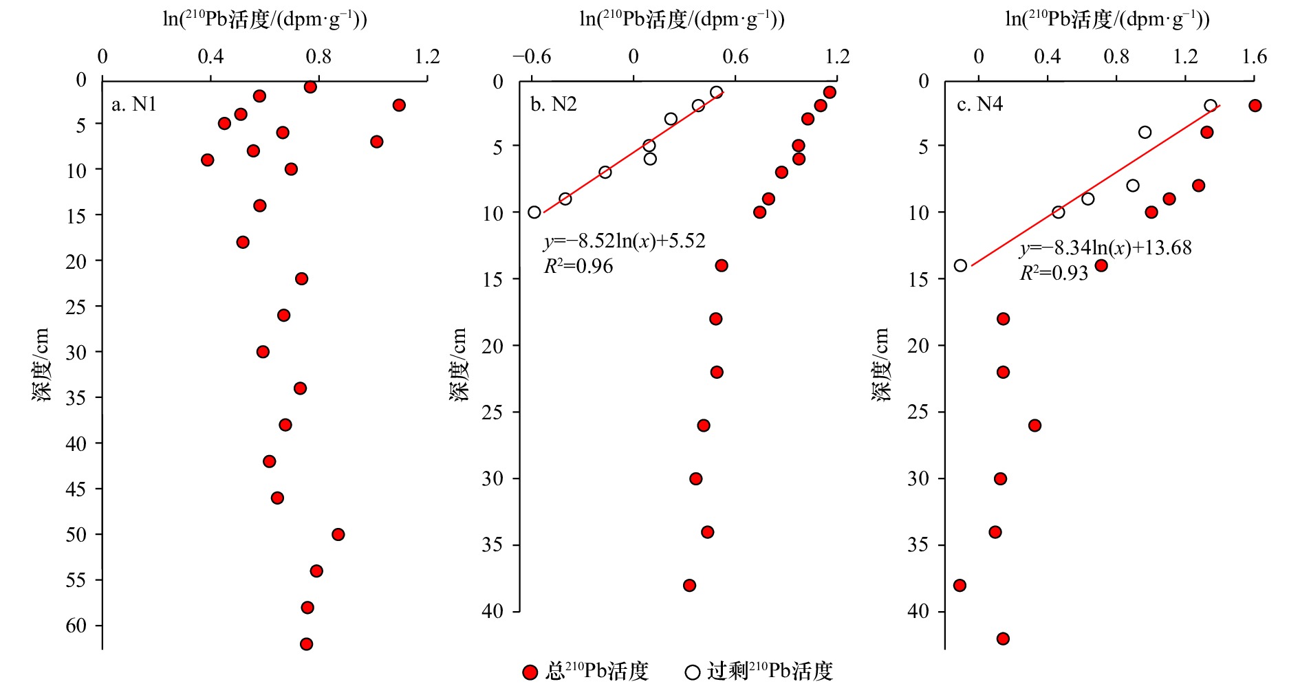
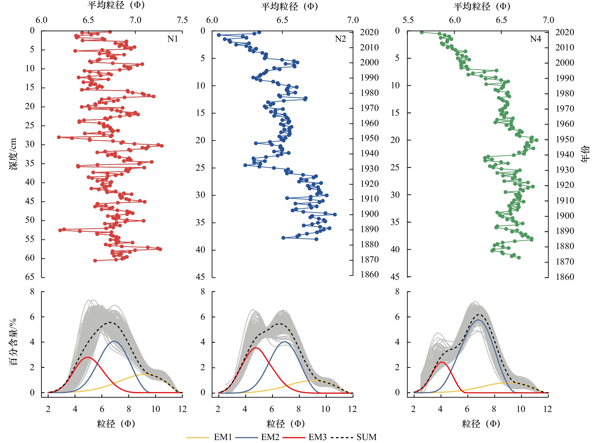
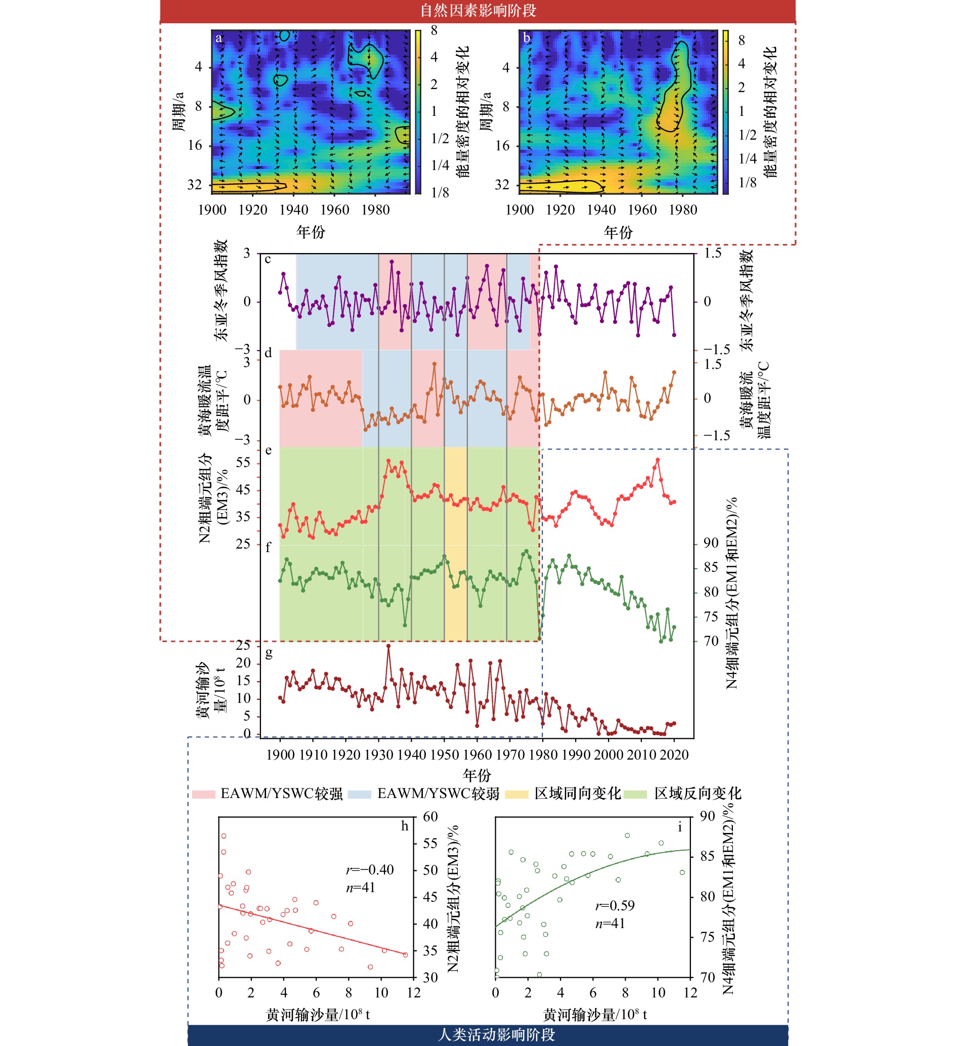
Paleoclimate and paleoenvironment reconstruction based on shelf mud deposits remain controversial due to the complexity of coastal dynamic conditions. In this paper, three sediment cores distributed along the sediment transport path in the North Yellow Sea were collected, and the sediment grain size composition, end member, winter storms and Yellow Sea Warm Current strength variation were also analyzed. Based on above analysis, the response mechanism and intensity of different sediment grain size end member to winter storms and Yellow Sea Warm Current were discussed, and sedimentary effect in different regions caused by the above changes was also revealed. The results show that sediment composition in the north branch of Huanghe River distal mud is dominated by the natural condition and human activity over the past 100 years, respectively. Due to the impact of human activities on the sediment flux and composition of the Huanghe River into the sea began to enhance since 1980, and the natural evolution information was destroyed. In addition, through comparing sediment end member of different cores along the sediment transport pathway, the discrepancy in response mechanism and intensity of different end member to winter storms and the Yellow Sea Warm Current were observed before 1980, which reflected significant regional sedimentation effect. Further analysis demonstrated that, the coarse-grained end member is dominated by the winter storm, reflecting intensity of cross-front transport from the north Shandong Peninsula; and the fine-grained end member is controlled by the Yellow Sea Warm Current, representing the long distance transport from the offshore mud patch of the western North Yellow Sea to the eastern coast of the Liaodong Peninsula. Above conclusions indicated that, the sediment grain size is a robust tool for paleoclimate and paleoenvironment reconstruction; however, the utility of sensitive grain size should be based on sediment source and the characteristics of the sediment hydrodynamic environment analysis, and selection of the sensitive grain size and its implication should be careful.
Paleoclimate and paleoenvironment reconstruction based on shelf mud deposits remain controversial due to the complexity of coastal dynamic conditions. In this paper, three sediment cores distributed along the sediment transport path in the North Yellow Sea were collected, and the sediment grain size composition, end member, winter storms and Yellow Sea Warm Current strength variation were also analyzed. Based on above analysis, the response mechanism and intensity of different sediment grain size end member to winter storms and Yellow Sea Warm Current were discussed, and sedimentary effect in different regions caused by the above changes was also revealed. The results show that sediment composition in the north branch of Huanghe River distal mud is dominated by the natural condition and human activity over the past 100 years, respectively. Due to the impact of human activities on the sediment flux and composition of the Huanghe River into the sea began to enhance since 1980, and the natural evolution information was destroyed. In addition, through comparing sediment end member of different cores along the sediment transport pathway, the discrepancy in response mechanism and intensity of different end member to winter storms and the Yellow Sea Warm Current were observed before 1980, which reflected significant regional sedimentation effect. Further analysis demonstrated that, the coarse-grained end member is dominated by the winter storm, reflecting intensity of cross-front transport from the north Shandong Peninsula; and the fine-grained end member is controlled by the Yellow Sea Warm Current, representing the long distance transport from the offshore mud patch of the western North Yellow Sea to the eastern coast of the Liaodong Peninsula. Above conclusions indicated that, the sediment grain size is a robust tool for paleoclimate and paleoenvironment reconstruction; however, the utility of sensitive grain size should be based on sediment source and the characteristics of the sediment hydrodynamic environment analysis, and selection of the sensitive grain size and its implication should be careful.

2023, 45(2): 85-97.
doi: 10.12284/hyxb2023025
Abstract:
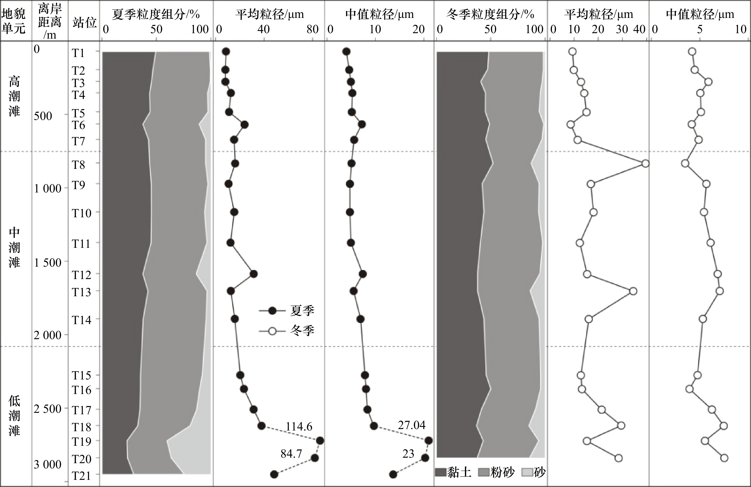
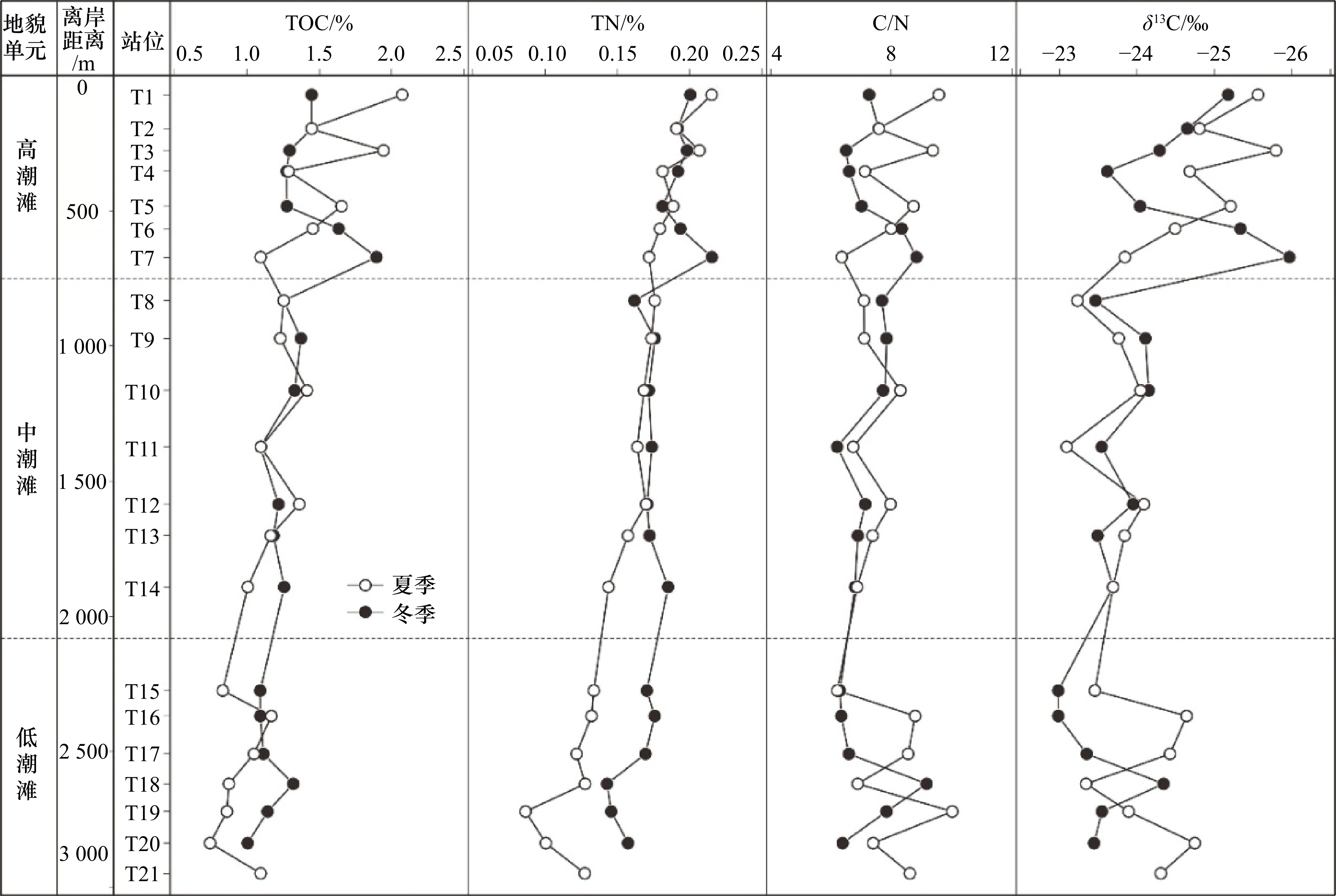
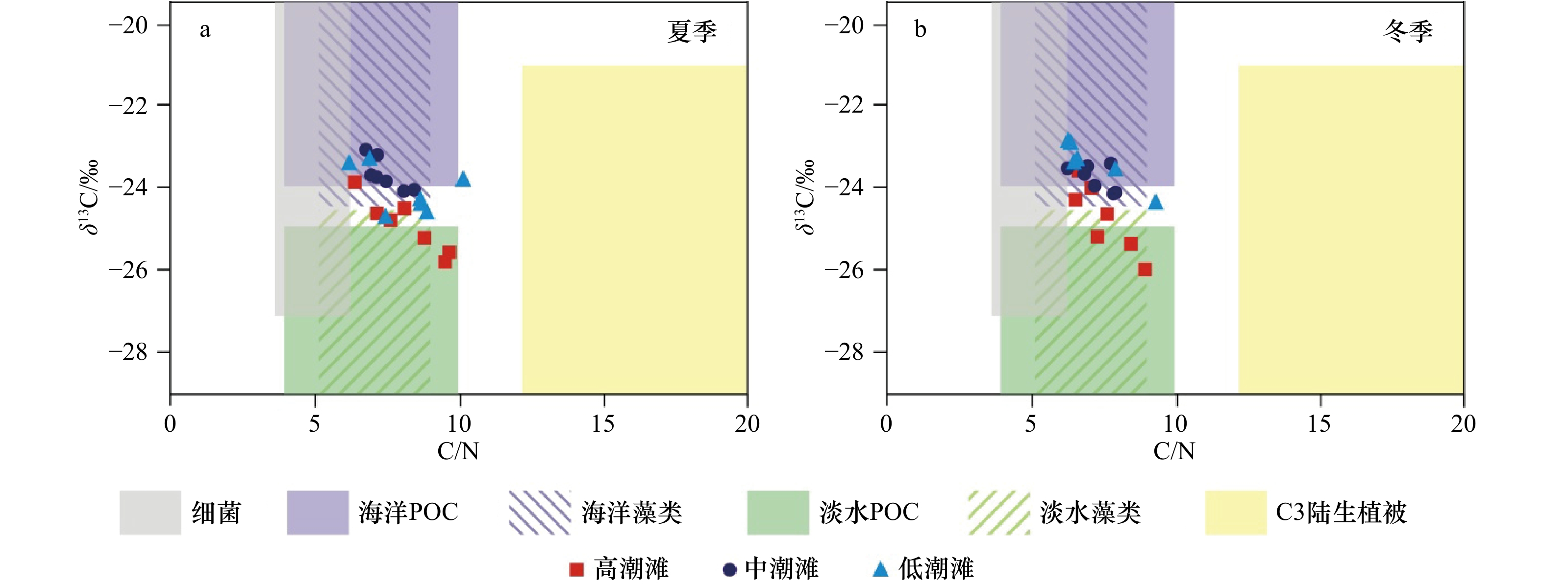
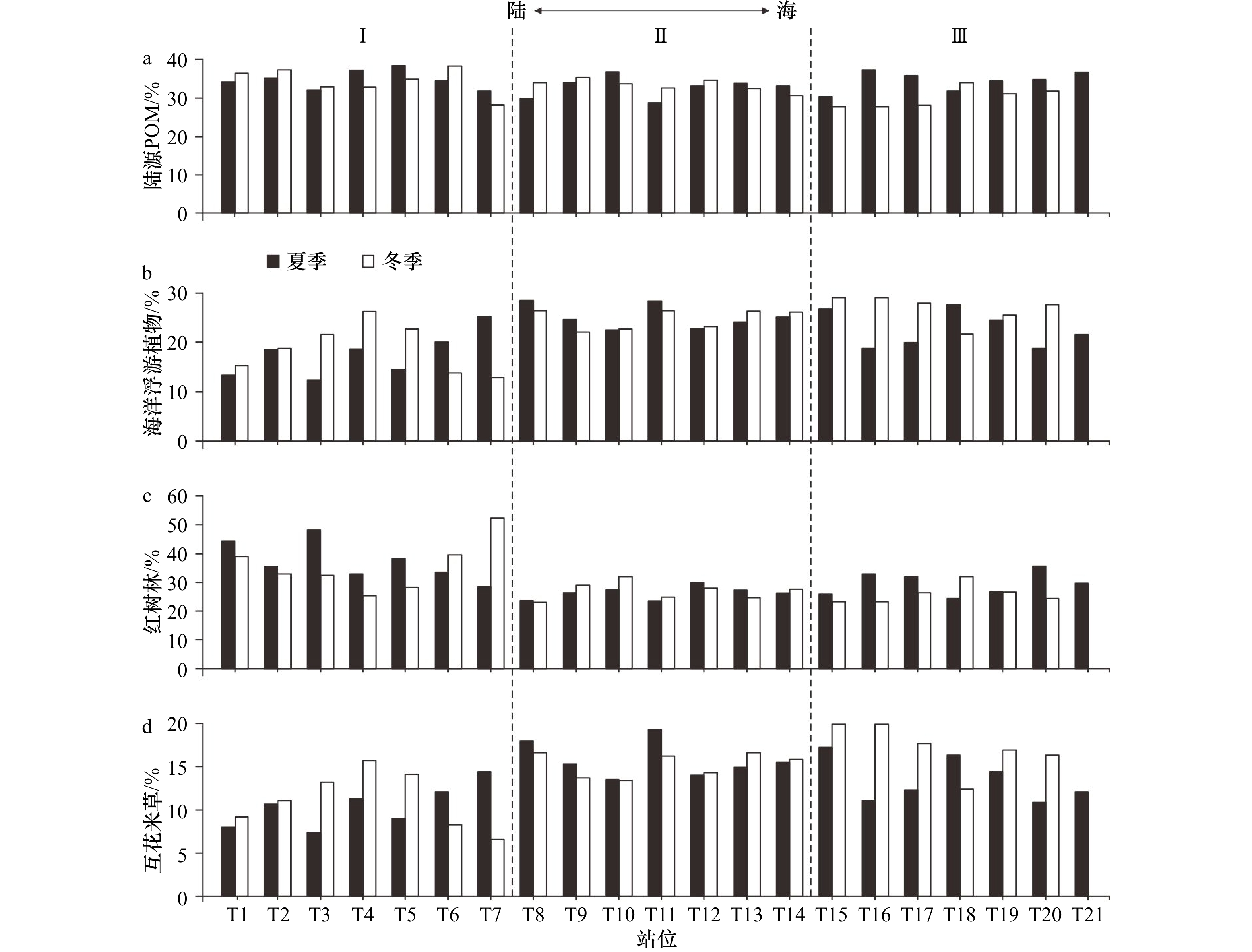
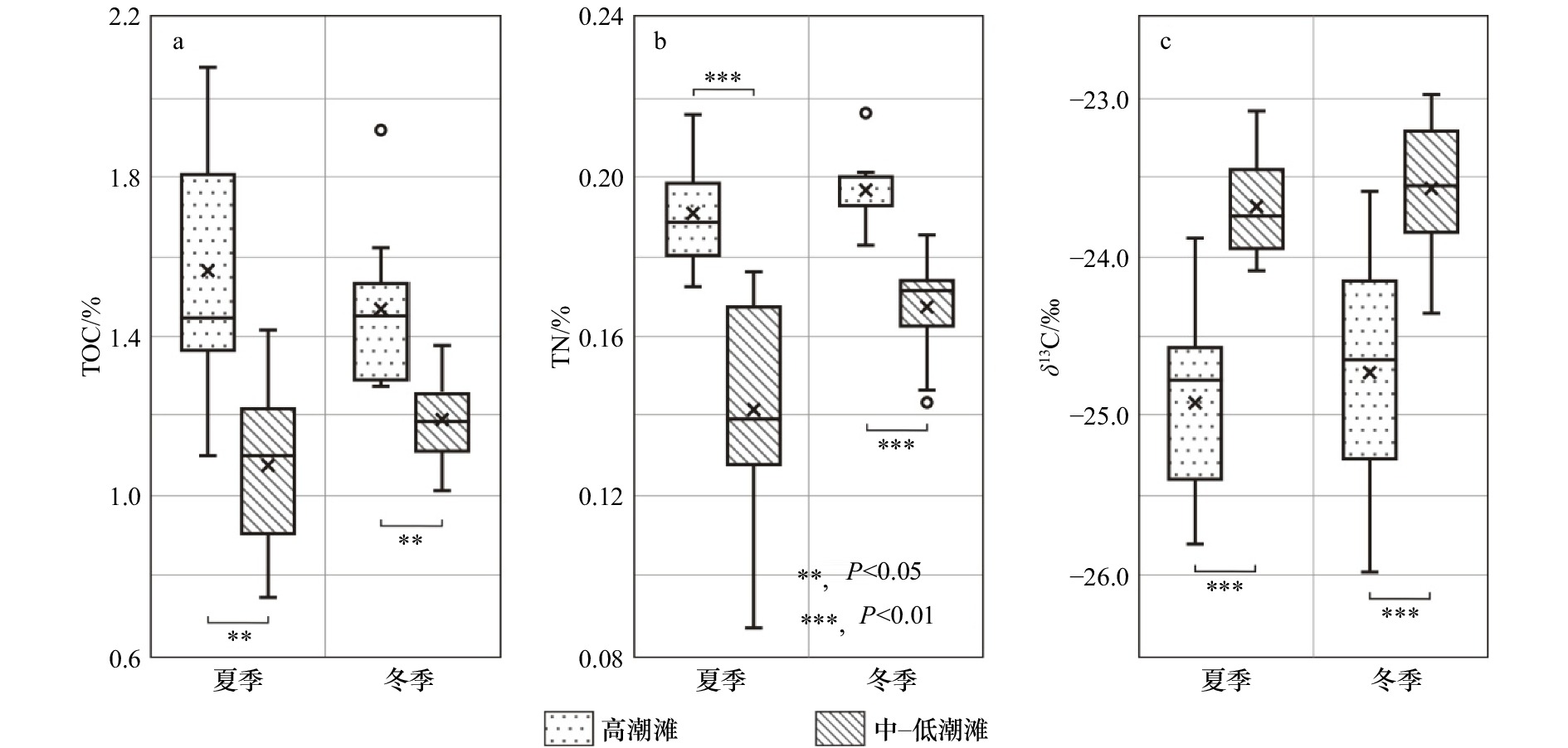
This article is focus on the distribution and source of organic matter in tidal flat in the Jiulong River Estuary, and to seek effective organic geochemistry proxies for recognize sedimentary microfacies, and thus to help that organic carbon is better applied to identify sedimentary microfacies and paleo-environment. Forty one surficial sediment samples were obtained and measured their grain size, total organic carbon (TOC), total nitrogen (TN), and organic carbon stable isotopes (δ13C) in the tidal flat from three sedimentary environments: upper tidal flat, middle tidal flat and lower tidal flat in summer and winter. The results show that, from upper tidal flat to lower tidal flat, the grain size of sediments becomes coarser gradually with decreasing TOC, TN and C/N, and the increase of δ13C. The sources of organic matter in the upper tidal flat are dominated by terrestrial organic matter and mangrove, marine organic matter and Spartina alterniflora in middle tidal, and marine organic matter in lower tidal flat. The distribution and sources of organic carbon in tidal flat from the Jiulong River Estuary are controlled by the seasonal changes of land-ocean interaction, sedimentary hydrodynamic sorting, and plants. There is a significant difference in TOC, and a highly significant difference in TN and δ13C in sediments of the tidal flat. We thus proposed that organic geochemistry properties TOC, TN and δ13C are the effective indicators to identify upper tidal flat and middle-lower tidal flat in the Jiulong River Estuary.
This article is focus on the distribution and source of organic matter in tidal flat in the Jiulong River Estuary, and to seek effective organic geochemistry proxies for recognize sedimentary microfacies, and thus to help that organic carbon is better applied to identify sedimentary microfacies and paleo-environment. Forty one surficial sediment samples were obtained and measured their grain size, total organic carbon (TOC), total nitrogen (TN), and organic carbon stable isotopes (δ13C) in the tidal flat from three sedimentary environments: upper tidal flat, middle tidal flat and lower tidal flat in summer and winter. The results show that, from upper tidal flat to lower tidal flat, the grain size of sediments becomes coarser gradually with decreasing TOC, TN and C/N, and the increase of δ13C. The sources of organic matter in the upper tidal flat are dominated by terrestrial organic matter and mangrove, marine organic matter and Spartina alterniflora in middle tidal, and marine organic matter in lower tidal flat. The distribution and sources of organic carbon in tidal flat from the Jiulong River Estuary are controlled by the seasonal changes of land-ocean interaction, sedimentary hydrodynamic sorting, and plants. There is a significant difference in TOC, and a highly significant difference in TN and δ13C in sediments of the tidal flat. We thus proposed that organic geochemistry properties TOC, TN and δ13C are the effective indicators to identify upper tidal flat and middle-lower tidal flat in the Jiulong River Estuary.


2023, 45(2): 98-109.
doi: 10.12284/hyxb2023005
Abstract:
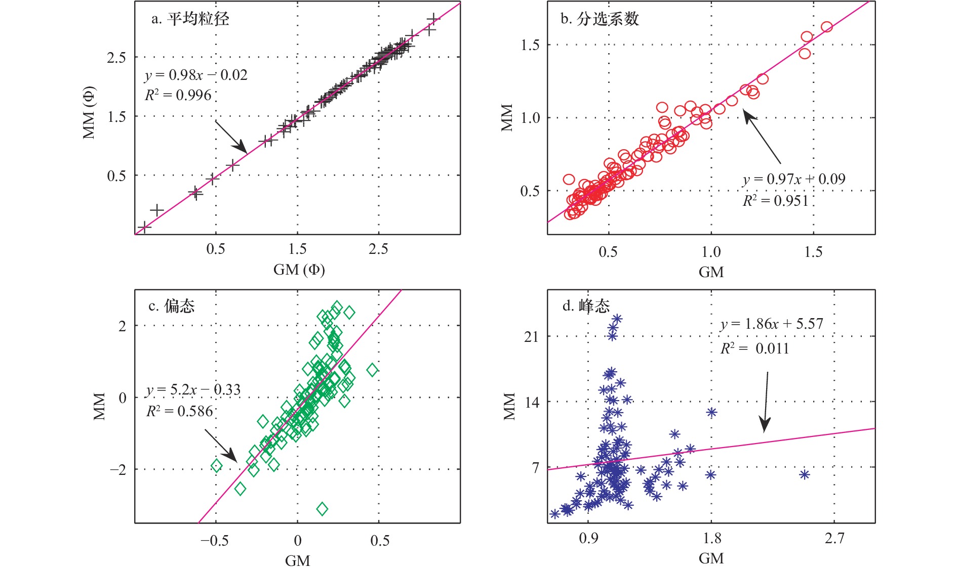
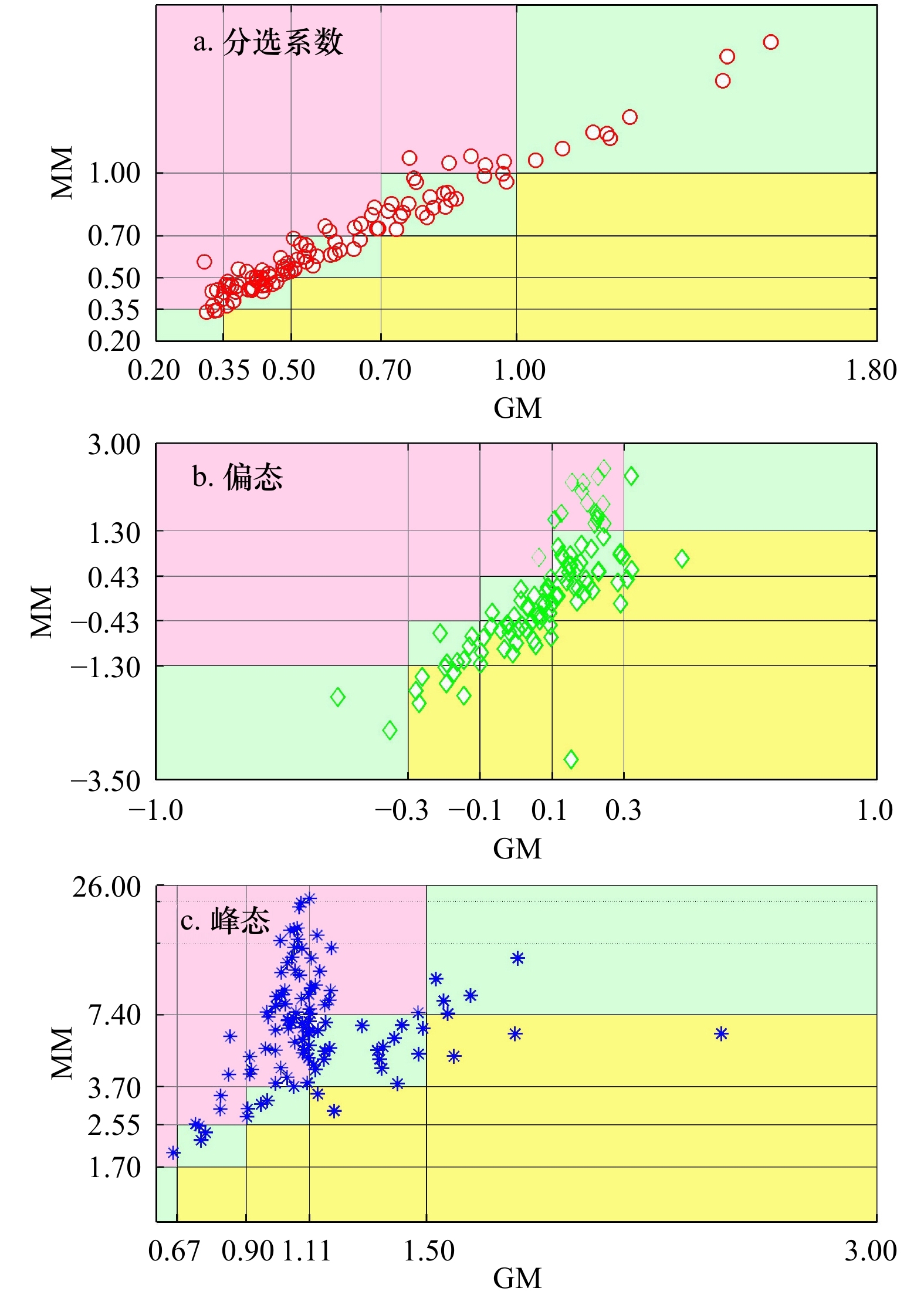
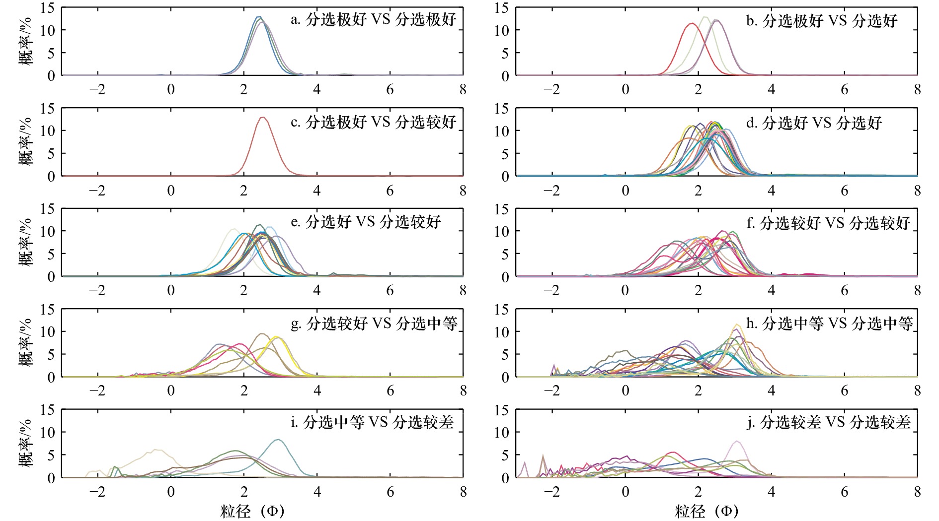
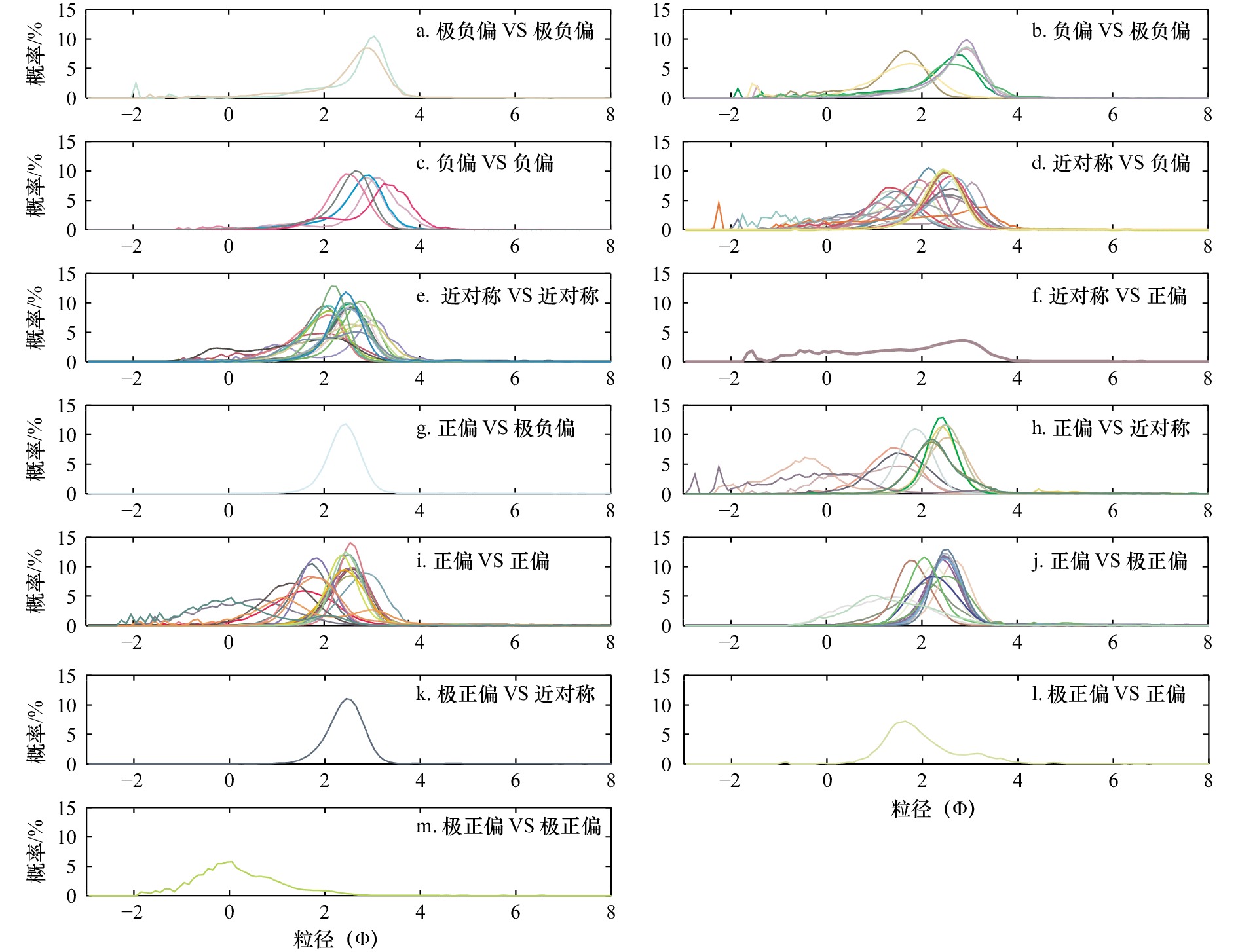
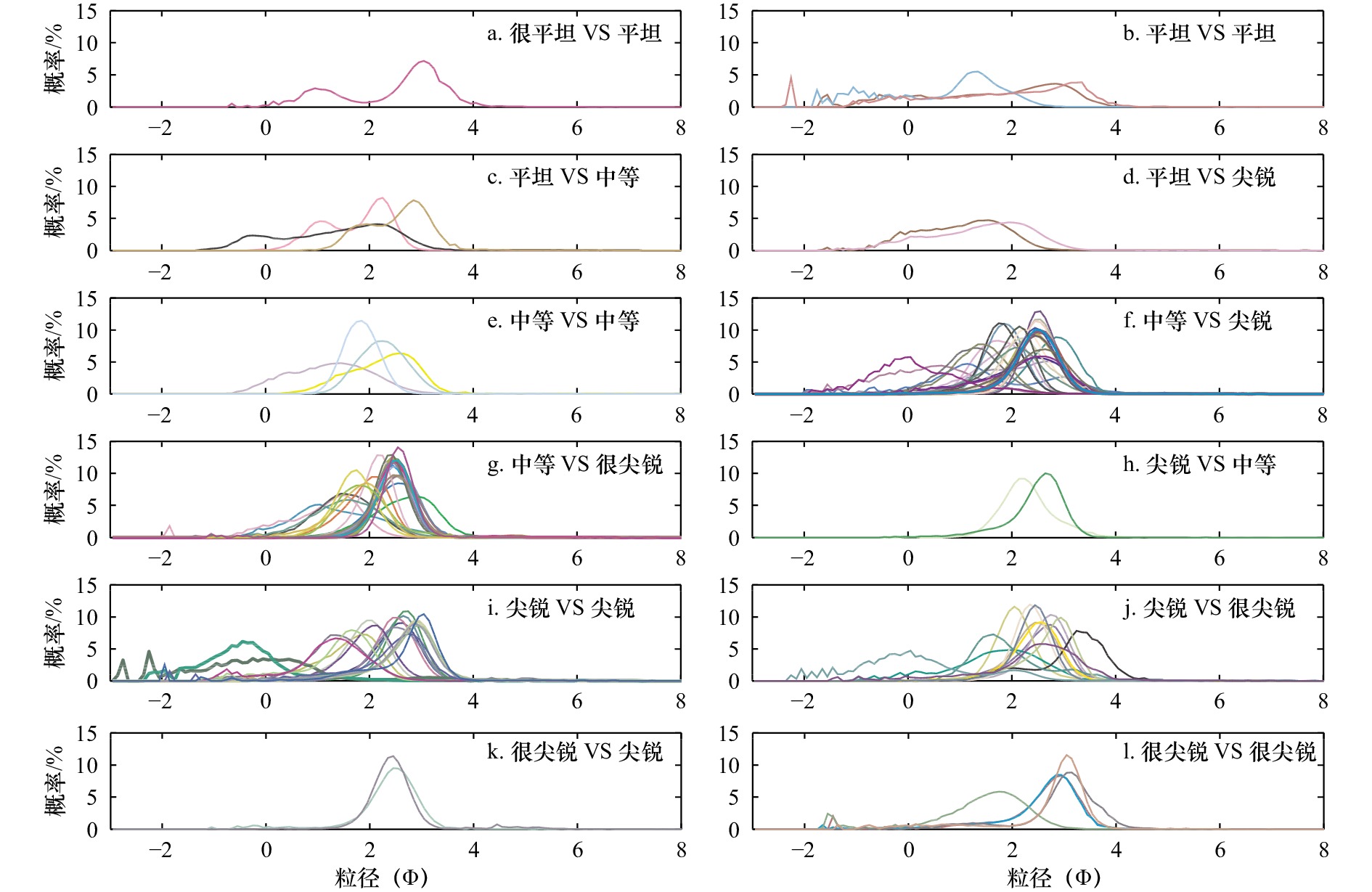
Little research attention has been paid to comparison of the descriptive terms used in graphical method and moment method for grains-size parameters, although some work has been done on comparison of the numerical values and mutual conversion equations. In this paper, 105 surface sediments from 22 sections of 15 beaches on both sides of the Qiongzhou Strait are selected as typical research objects. The grain-size parameter results are obtained by the Folk & Ward graphic method and Friedman moment method respectively. The regression relationship of quantitative results is constructed and the similarities and differences of qualitative results are compared. Combined with the previous research results, this paper further discusses the comparability of the results of the two methods, and analyzes the possible impact of the differences between the two methods on the extraction and use of sediment particle size information. The results show that: (1) in terms of quantitative results, the average particle size and sorting coefficient calculated by graphic method and moment method have strong correlation (R2 ≥ 0.951), while the skewness and kurtosis show moderate correlation (R2 = 0.586) and uncorrelation (R2 = 0.011), indicating that the correlation between the quantitative results of particle size parameters calculated by the two methods is not stable, which is basically consistent with the previous research results; (2) as far as qualitative results are concerned, there is a large deviation between the results of graphic method and moment method. The proportion of inconsistent sorting coefficient, skewness and kurtosis is 30.48%, 55.24% and 71.43% respectively, which deviates from the correlation of quantitative results to a certain extent, indicating that the correlation degree of quantitative results can not be fully used to indicate the consistency degree of qualitative term results. Since it is the goal of grain-size parameter analysis method to reveal the differences of sediments to the greatest extent, it is necessary to fully consider the characteristics of grain-size distribution curve when choosing which method to calculate grain-size parameters. This paper provides a typical case of comparing the results of graphical method and moment method for grain-size parameters of beach sediments. The research results help to improve the understanding of the differences, causes and scientific use of grain-size parameter analysis methods.
Little research attention has been paid to comparison of the descriptive terms used in graphical method and moment method for grains-size parameters, although some work has been done on comparison of the numerical values and mutual conversion equations. In this paper, 105 surface sediments from 22 sections of 15 beaches on both sides of the Qiongzhou Strait are selected as typical research objects. The grain-size parameter results are obtained by the Folk & Ward graphic method and Friedman moment method respectively. The regression relationship of quantitative results is constructed and the similarities and differences of qualitative results are compared. Combined with the previous research results, this paper further discusses the comparability of the results of the two methods, and analyzes the possible impact of the differences between the two methods on the extraction and use of sediment particle size information. The results show that: (1) in terms of quantitative results, the average particle size and sorting coefficient calculated by graphic method and moment method have strong correlation (R2 ≥ 0.951), while the skewness and kurtosis show moderate correlation (R2 = 0.586) and uncorrelation (R2 = 0.011), indicating that the correlation between the quantitative results of particle size parameters calculated by the two methods is not stable, which is basically consistent with the previous research results; (2) as far as qualitative results are concerned, there is a large deviation between the results of graphic method and moment method. The proportion of inconsistent sorting coefficient, skewness and kurtosis is 30.48%, 55.24% and 71.43% respectively, which deviates from the correlation of quantitative results to a certain extent, indicating that the correlation degree of quantitative results can not be fully used to indicate the consistency degree of qualitative term results. Since it is the goal of grain-size parameter analysis method to reveal the differences of sediments to the greatest extent, it is necessary to fully consider the characteristics of grain-size distribution curve when choosing which method to calculate grain-size parameters. This paper provides a typical case of comparing the results of graphical method and moment method for grain-size parameters of beach sediments. The research results help to improve the understanding of the differences, causes and scientific use of grain-size parameter analysis methods.
2023, 45(2): 110-117.
doi: 10.12284/hyxb2023015
Abstract:
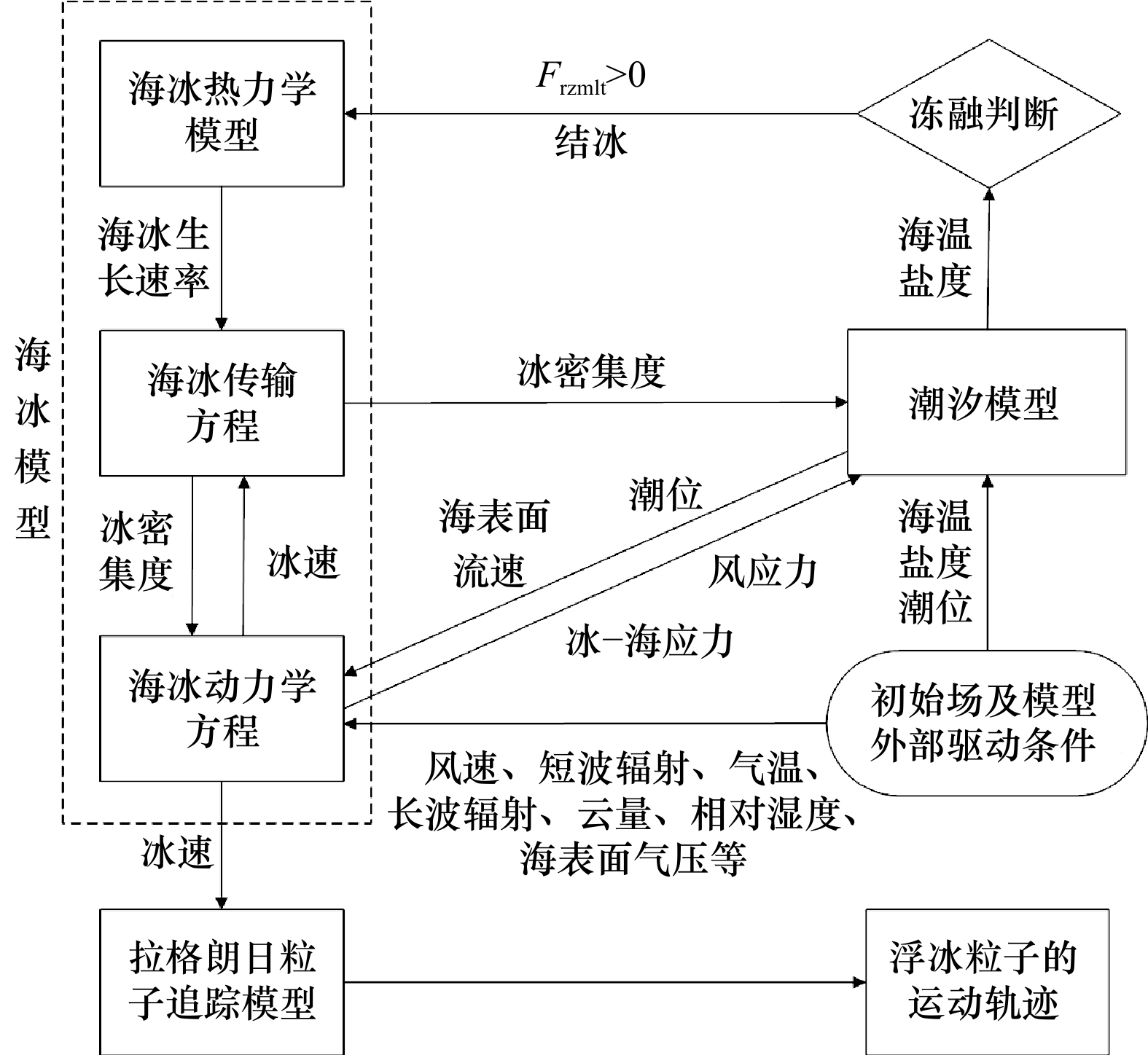
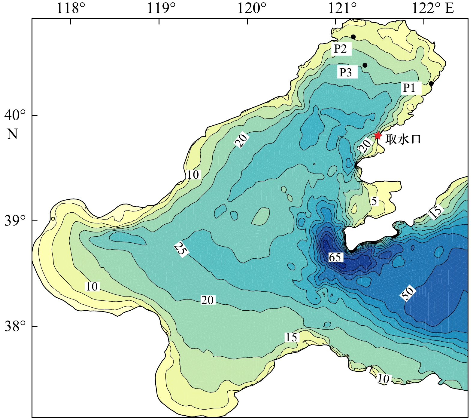
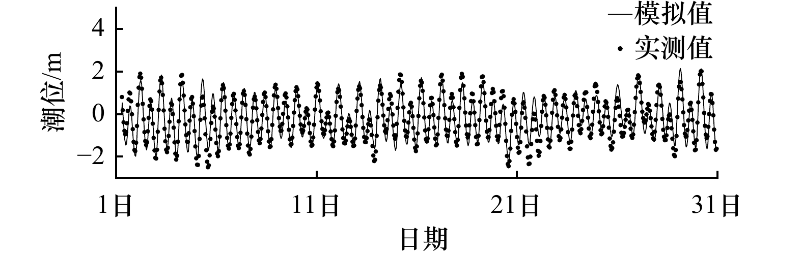
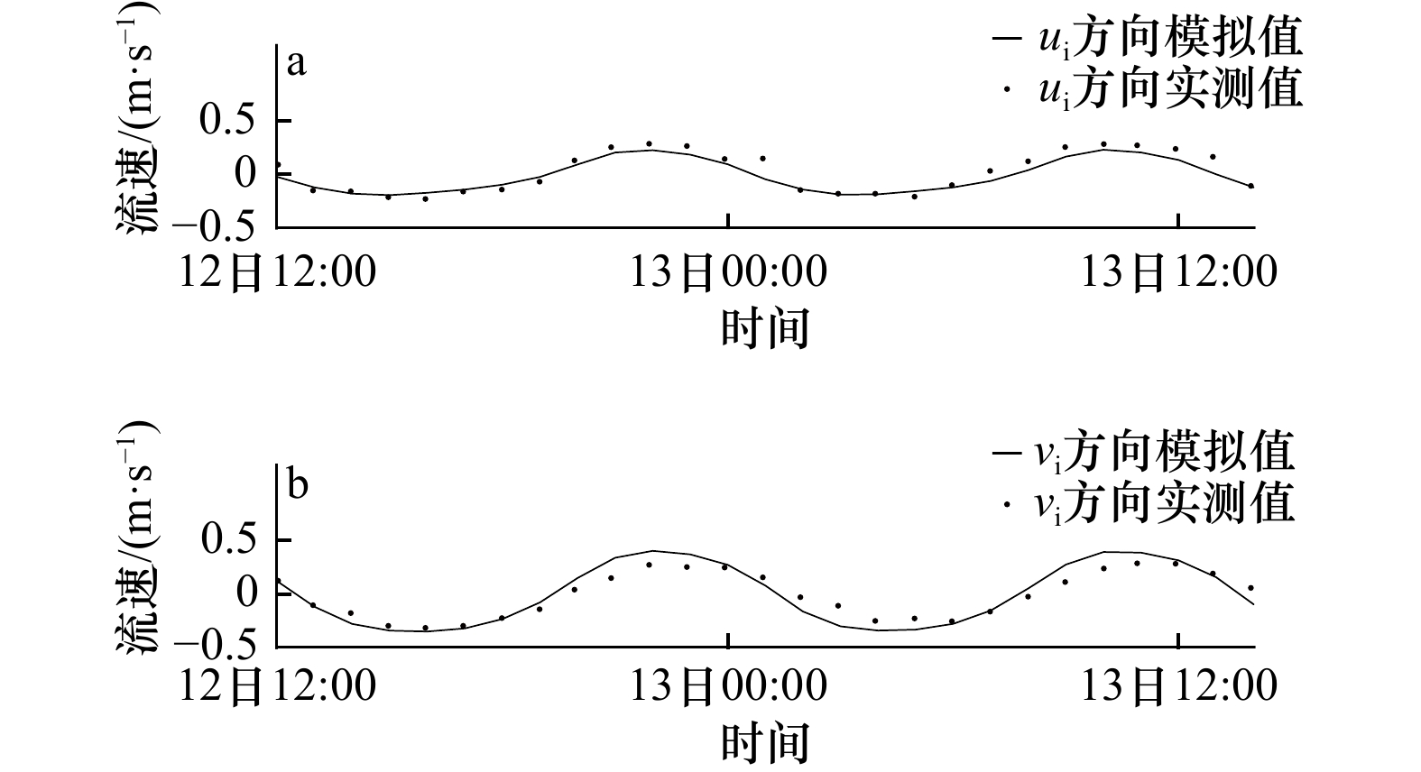
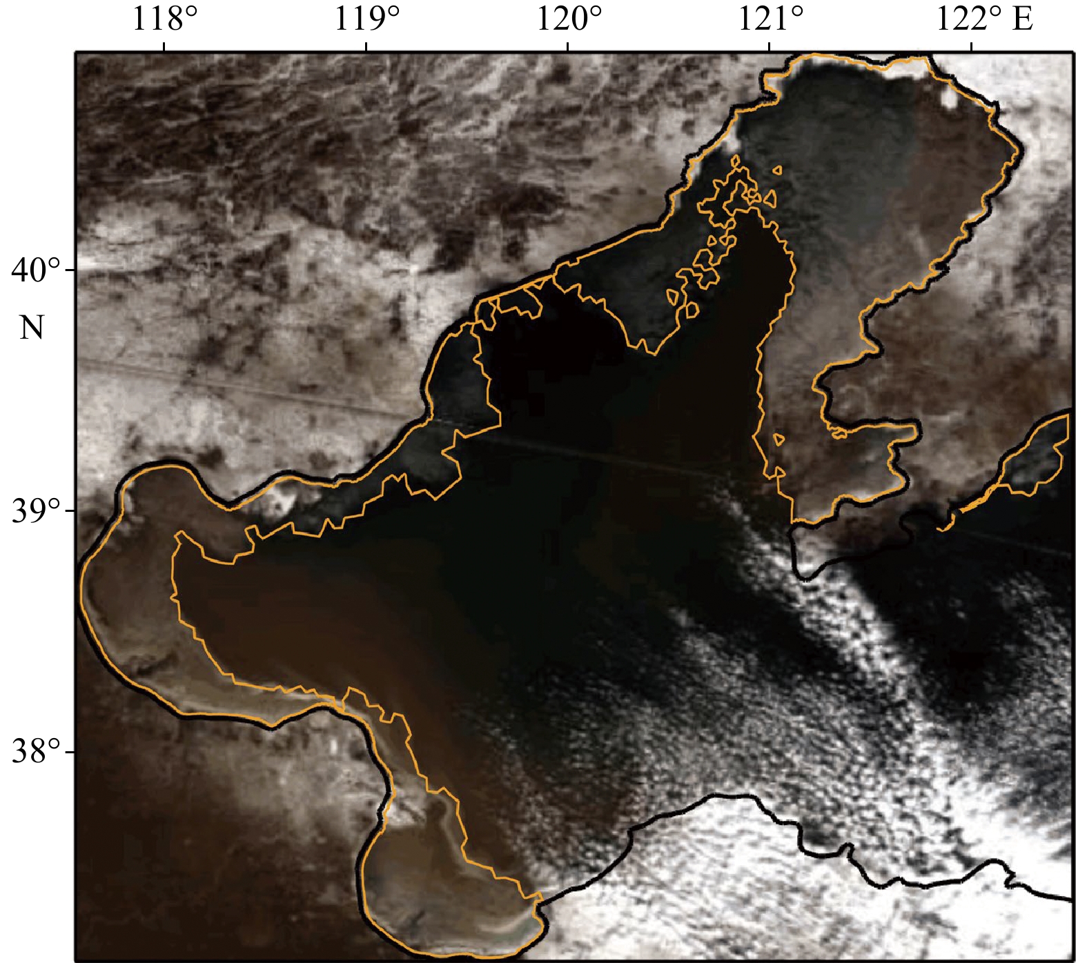
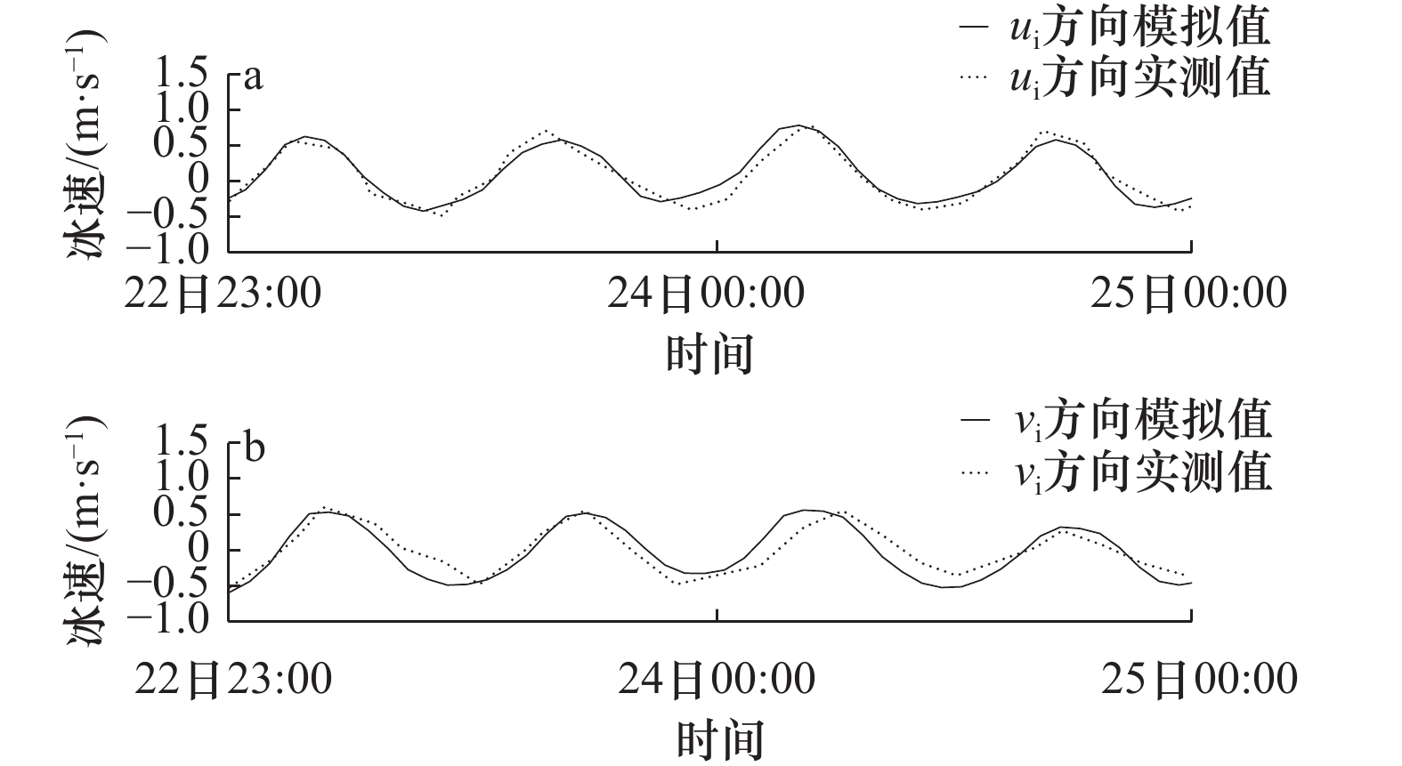
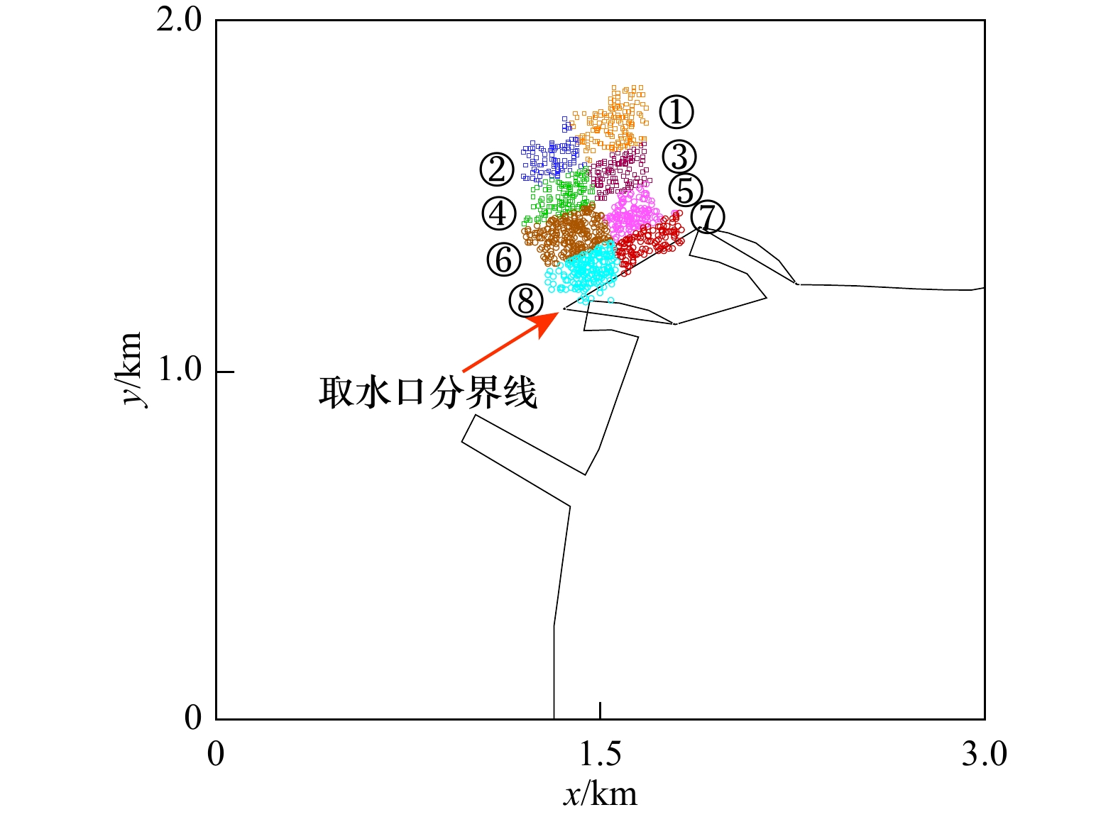
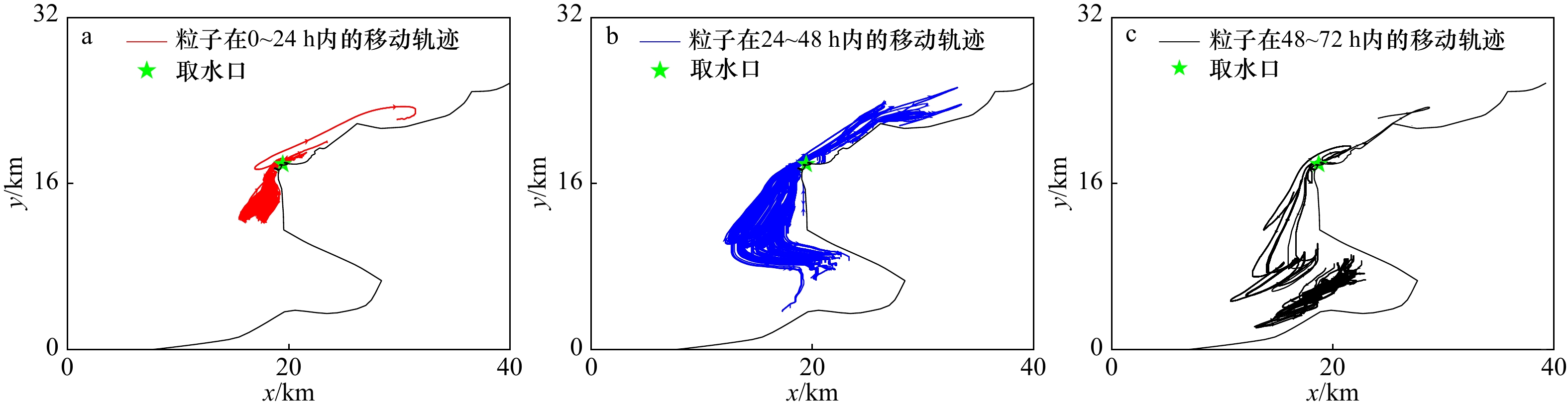
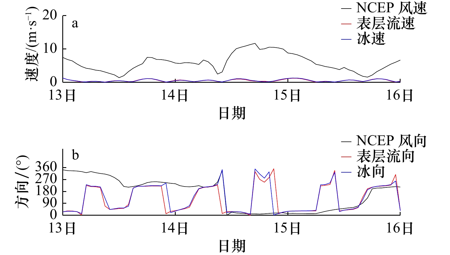
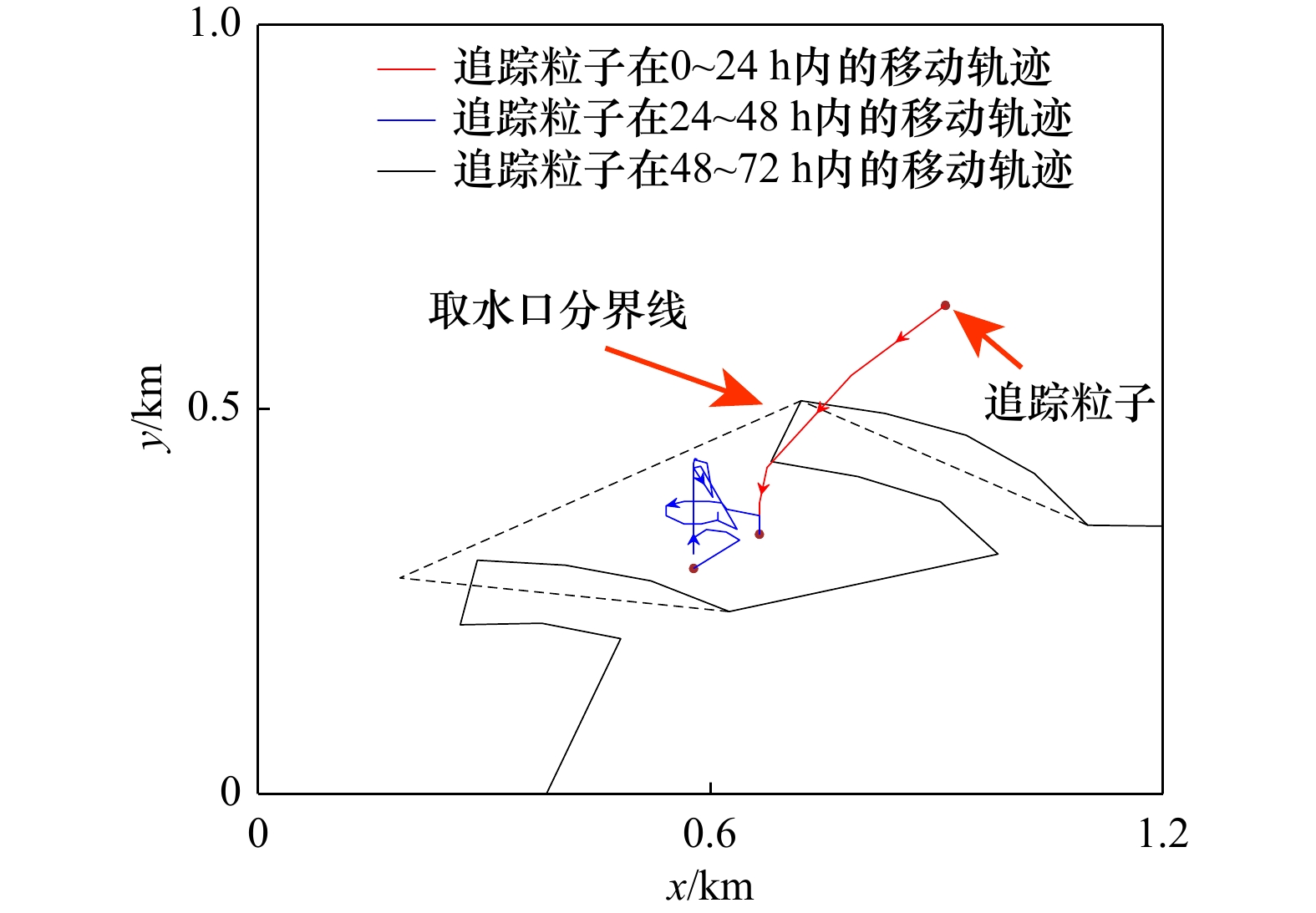
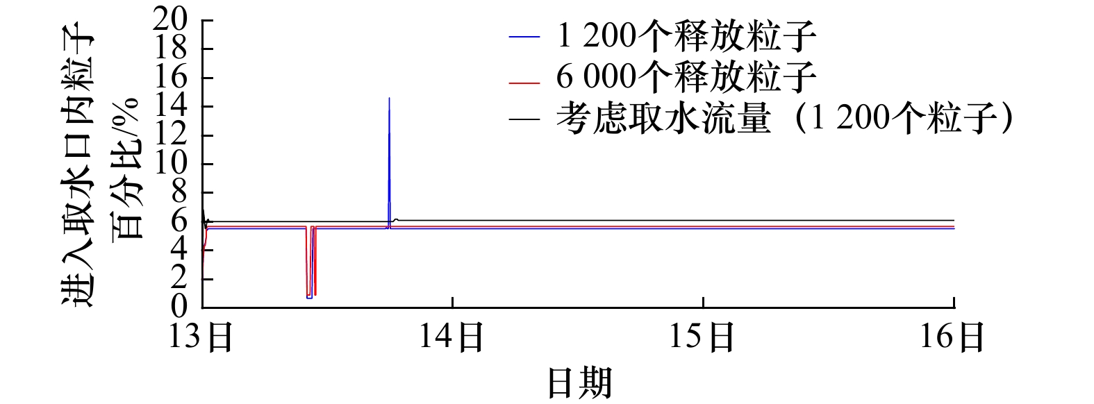
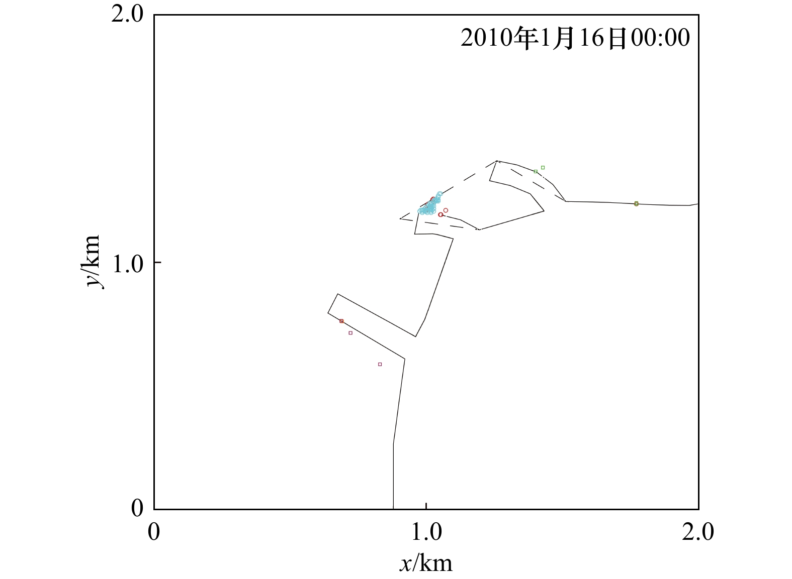
To provide technical support for sea ice environmental monitoring and dynamic risk early warning in the sea area of the proposed, under construction and built cold source water intake project in cold regions, a Lagrangian particle tracking prediction model under the sea ice ocean coupling condition is constructed in this paper. Taking the water intake of a nuclear power station in the Liaodong Bay as an example, the migration trajectories of high-risk ice blocks in 24 h, 48 h and 72 h under cold wave weather and the probability of entering the water intake are simulated and discussed. The results show that since the direction of the water intake is almost perpendicular to the flow direction and wind direction, less than 6% of the 1200 high-risk ice particles randomly released outside the water intake enter the water intake. It is found that most of the particles come from within 300 m near the water intake by identifying the particle color in different regions. The results of sensitivity analysis showed that when the number of released particles increased to 5 times, the conclusion remained unchanged. This study provides a new method for safety early warning of cold source water intake.
To provide technical support for sea ice environmental monitoring and dynamic risk early warning in the sea area of the proposed, under construction and built cold source water intake project in cold regions, a Lagrangian particle tracking prediction model under the sea ice ocean coupling condition is constructed in this paper. Taking the water intake of a nuclear power station in the Liaodong Bay as an example, the migration trajectories of high-risk ice blocks in 24 h, 48 h and 72 h under cold wave weather and the probability of entering the water intake are simulated and discussed. The results show that since the direction of the water intake is almost perpendicular to the flow direction and wind direction, less than 6% of the 1200 high-risk ice particles randomly released outside the water intake enter the water intake. It is found that most of the particles come from within 300 m near the water intake by identifying the particle color in different regions. The results of sensitivity analysis showed that when the number of released particles increased to 5 times, the conclusion remained unchanged. This study provides a new method for safety early warning of cold source water intake.
2023, 45(2): 118-129.
doi: 10.12284/hyxb2023009
Abstract:
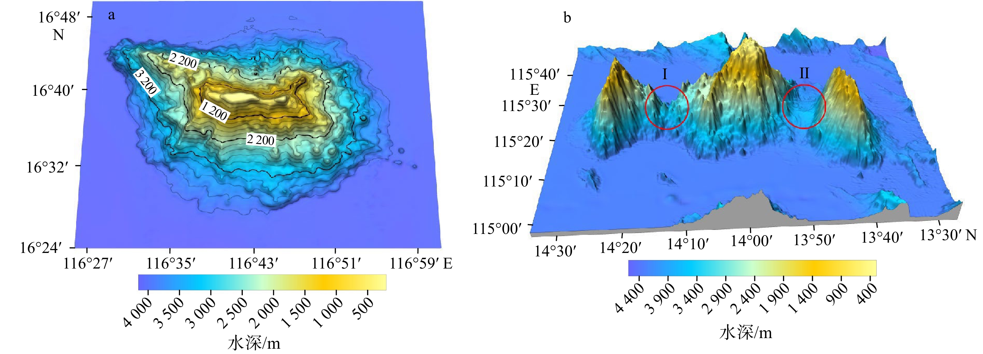
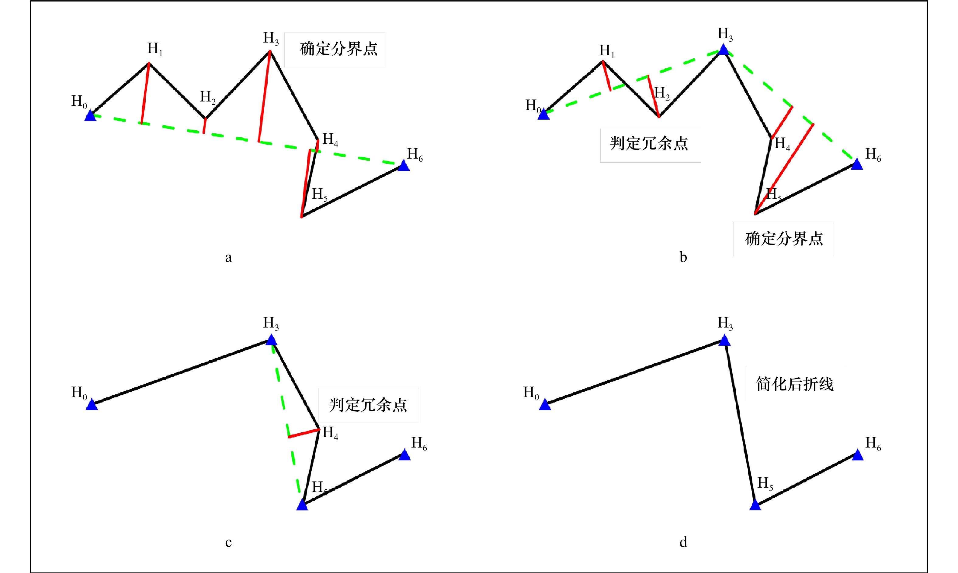
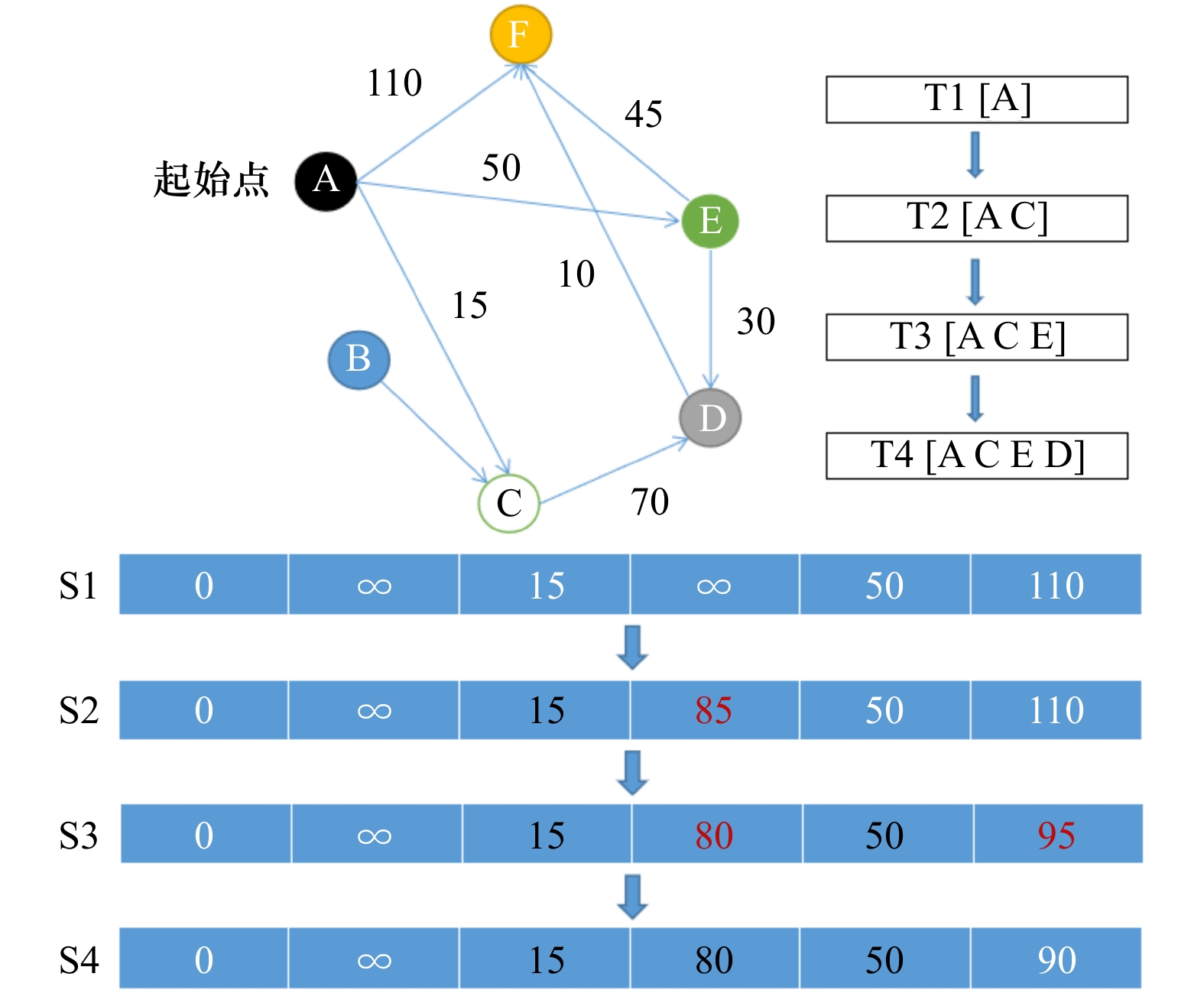
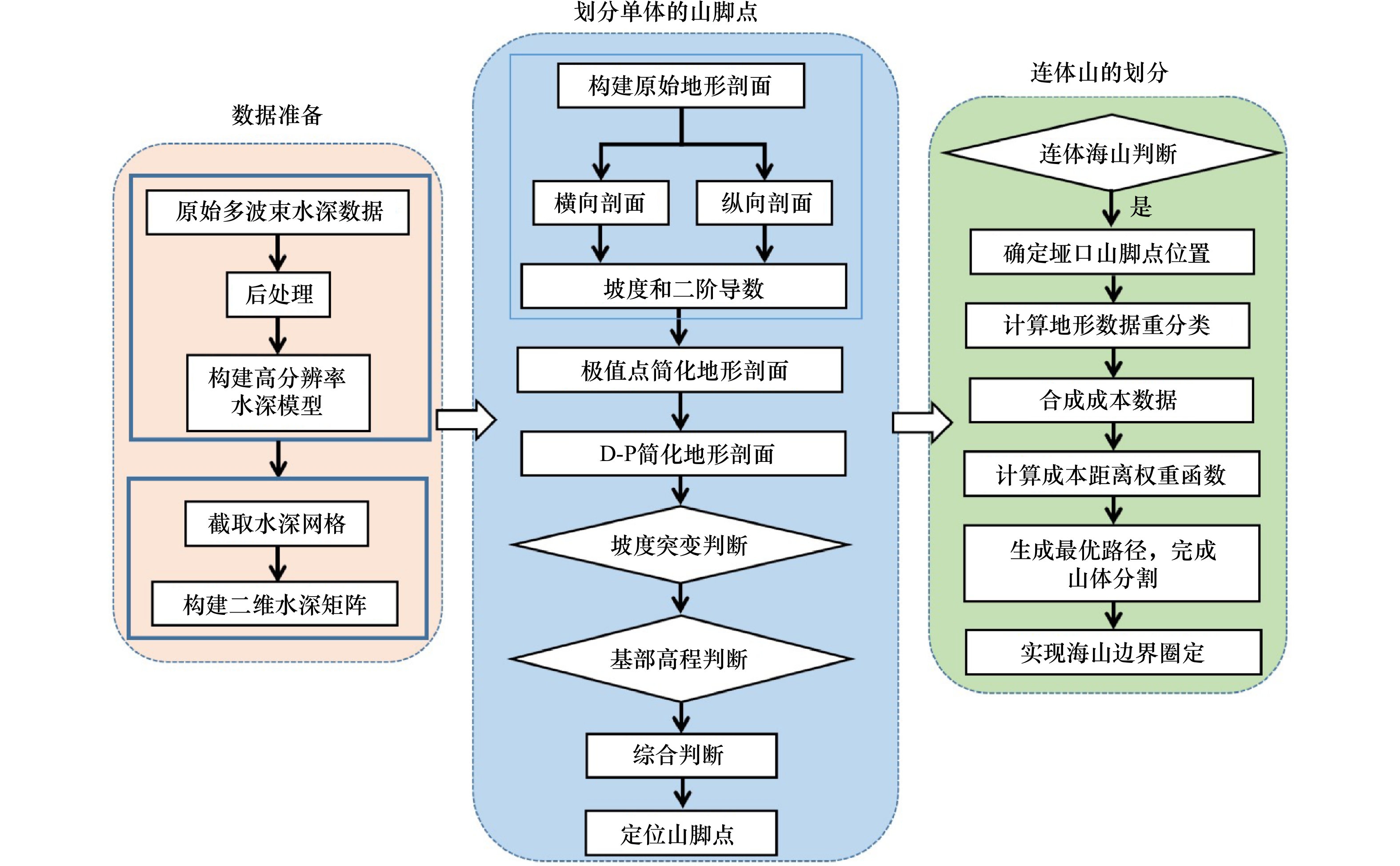
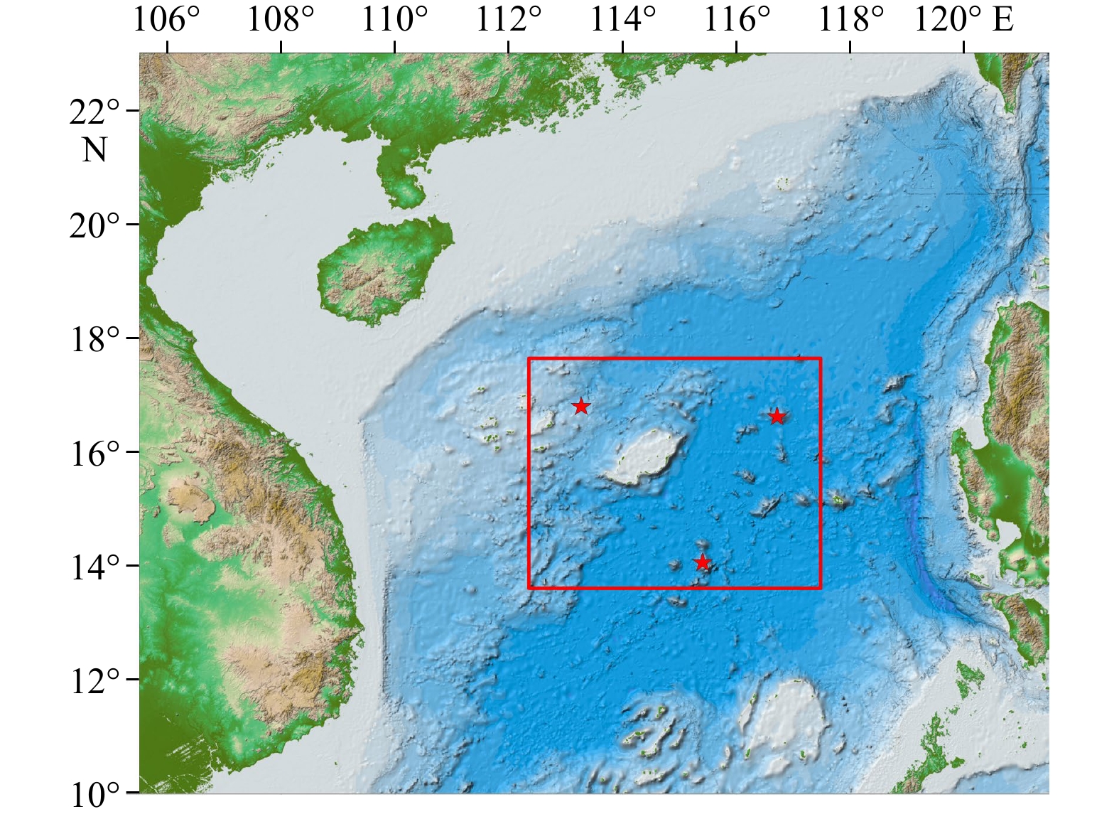
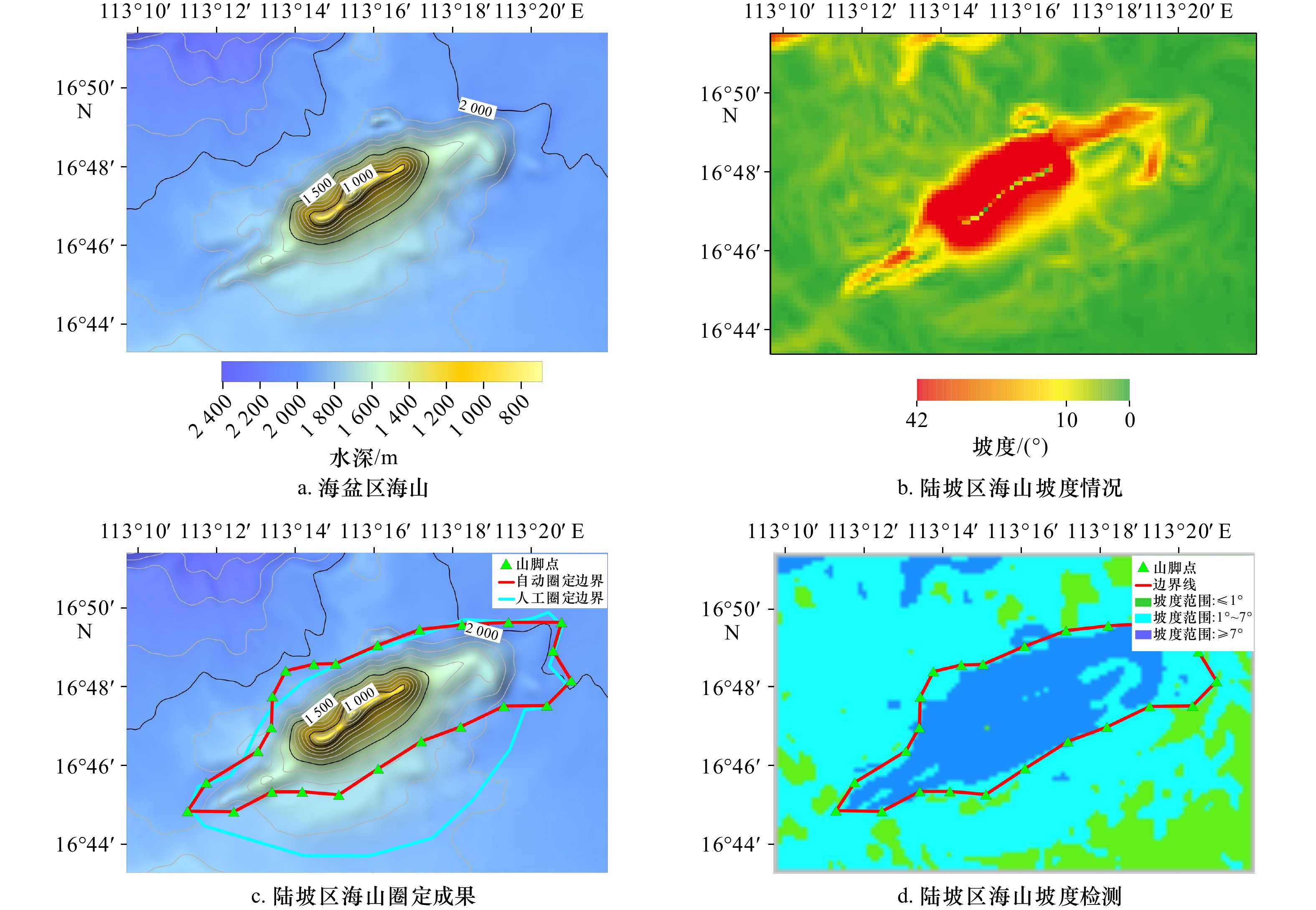
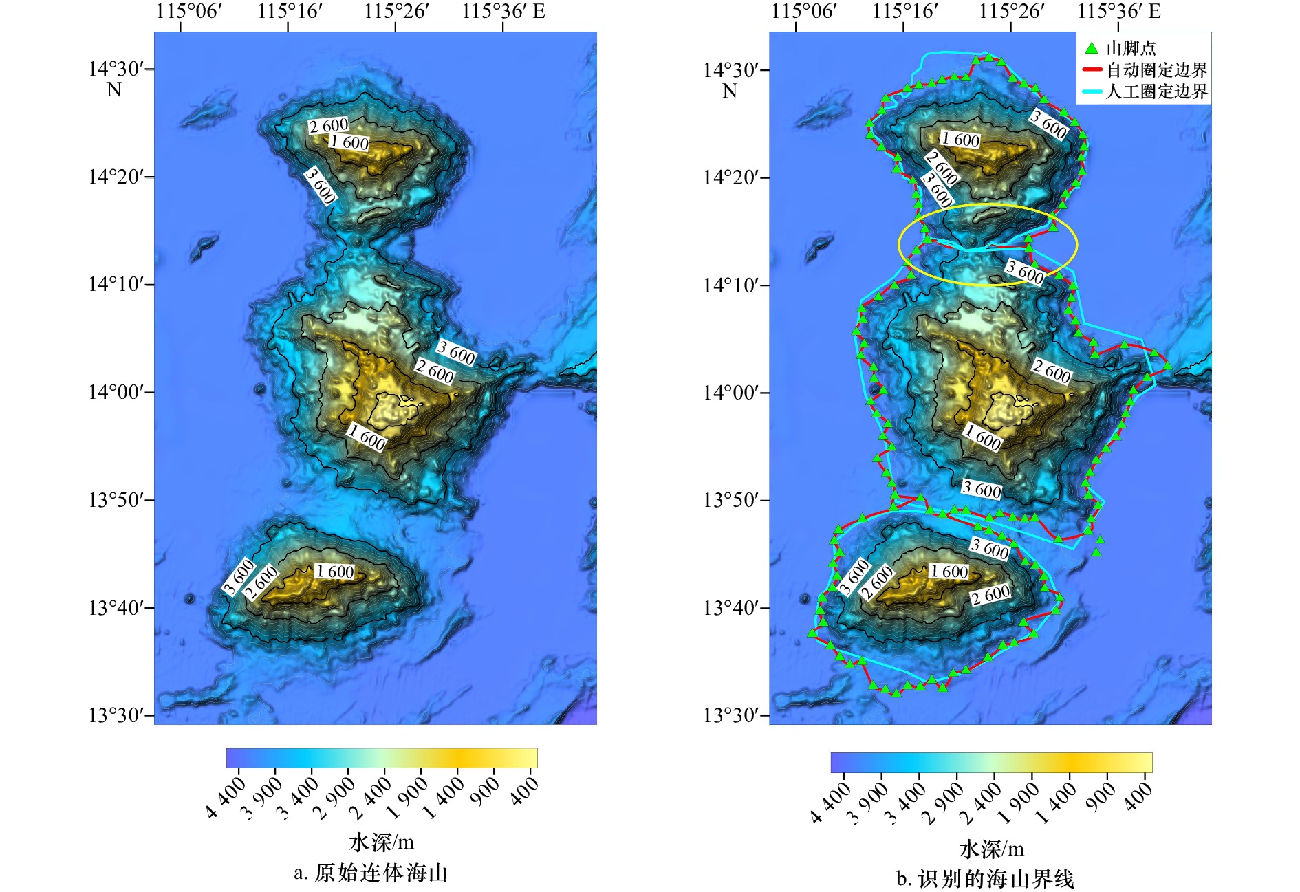
The delimitation and naming of seabed geographic entities is one of the hot research issues in the field of international maritime rights and interests. However, due to the lack of quantitative definition technology for the boundaries of seabed geographic entities, the determination of the boundaries is inevitably artificial. For this reason, this paper proposes a method for the boundary delineation of seabed geographic entities based on the D-P algorithm and optimal path. Convert the high-resolution bathymetry model into a two-dimensional bathymetry matrix, conduct cross-section analysis from the horizontal and vertical directions, and use extreme point simplification and D-P algorithm for quadratic simplification. In this way, the automatic division of the mountain body and its base of a single seamount is realized; on this basis, the method of path optimization is used to realize the automatic segmentation of conjoined seamounts. The method has been verified in the delineation of seabed geographic entities in the South China Sea and achieved good application results.
The delimitation and naming of seabed geographic entities is one of the hot research issues in the field of international maritime rights and interests. However, due to the lack of quantitative definition technology for the boundaries of seabed geographic entities, the determination of the boundaries is inevitably artificial. For this reason, this paper proposes a method for the boundary delineation of seabed geographic entities based on the D-P algorithm and optimal path. Convert the high-resolution bathymetry model into a two-dimensional bathymetry matrix, conduct cross-section analysis from the horizontal and vertical directions, and use extreme point simplification and D-P algorithm for quadratic simplification. In this way, the automatic division of the mountain body and its base of a single seamount is realized; on this basis, the method of path optimization is used to realize the automatic segmentation of conjoined seamounts. The method has been verified in the delineation of seabed geographic entities in the South China Sea and achieved good application results.


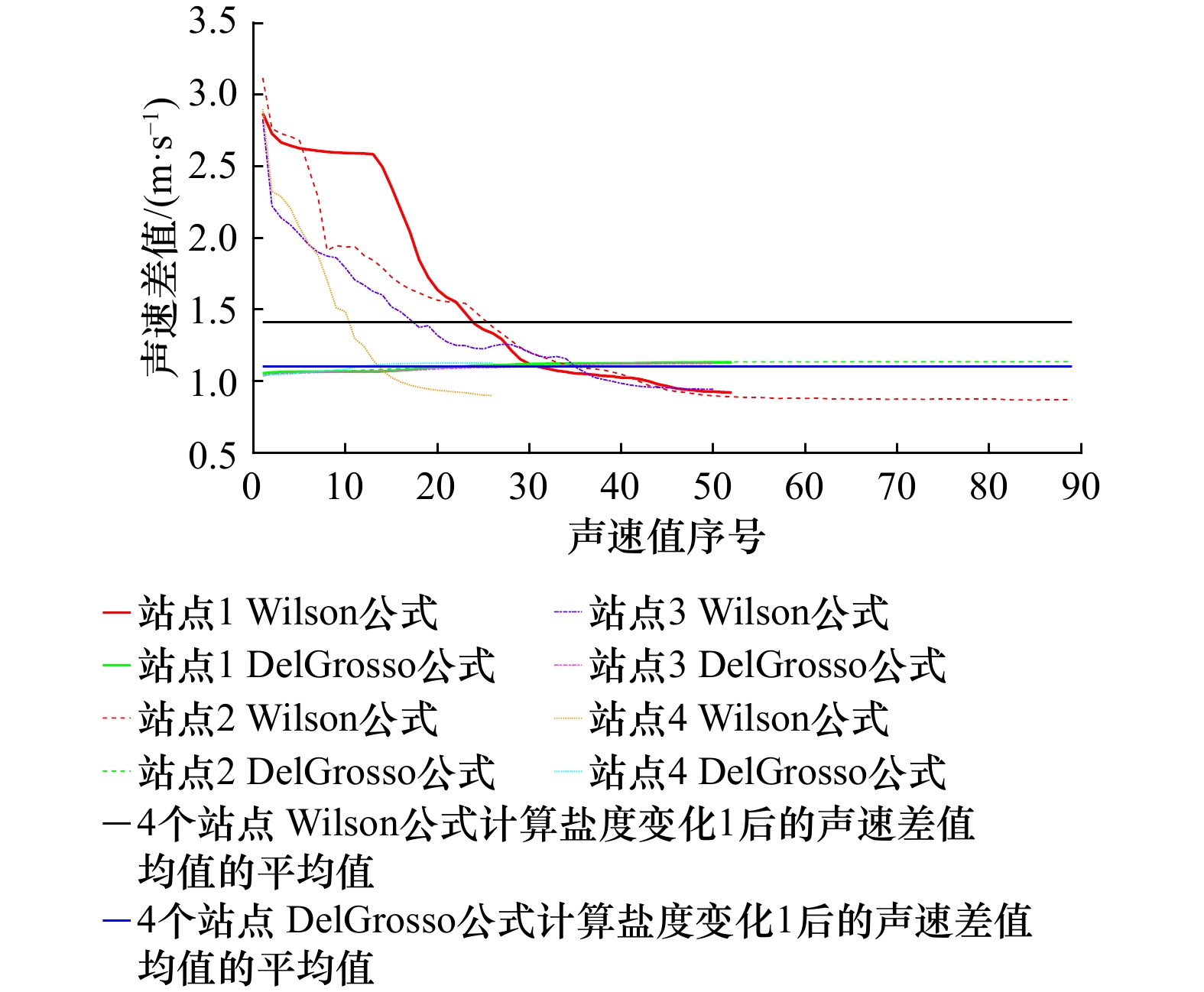
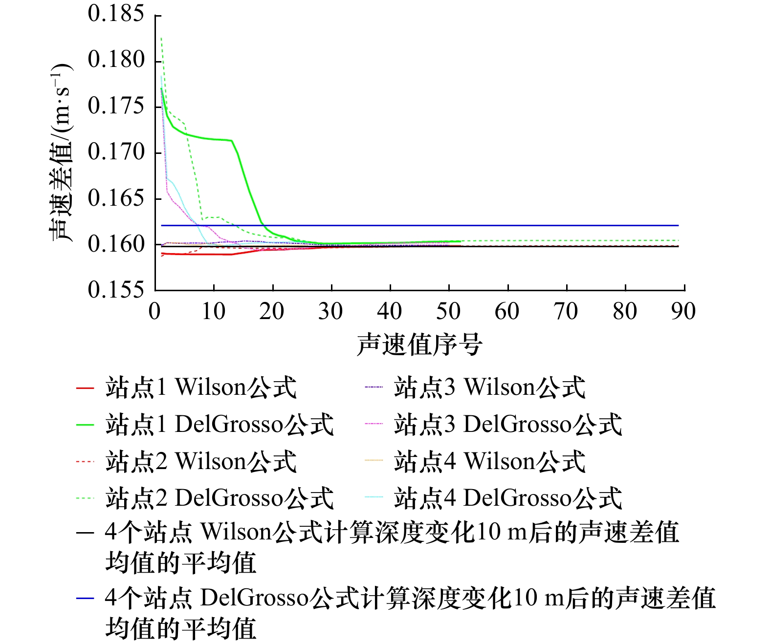
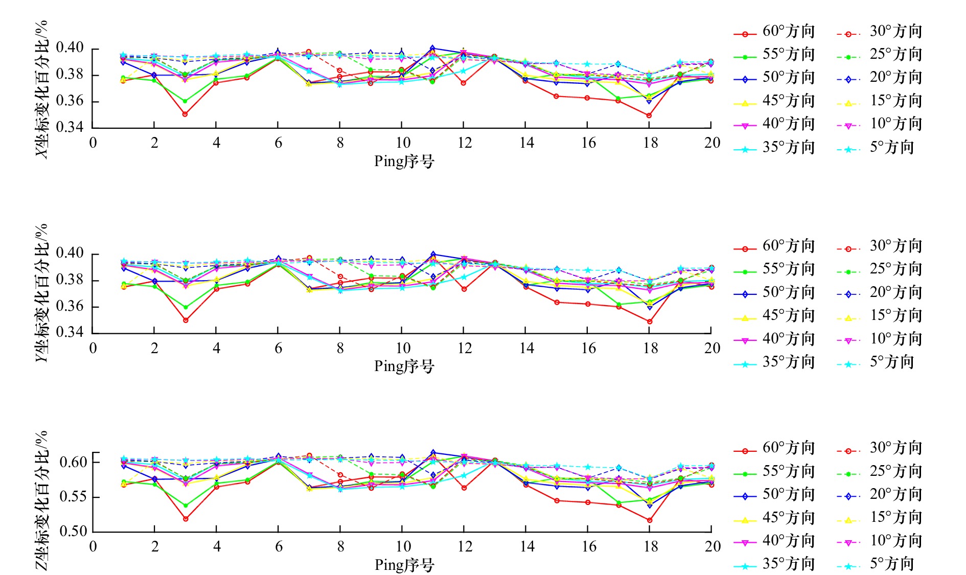
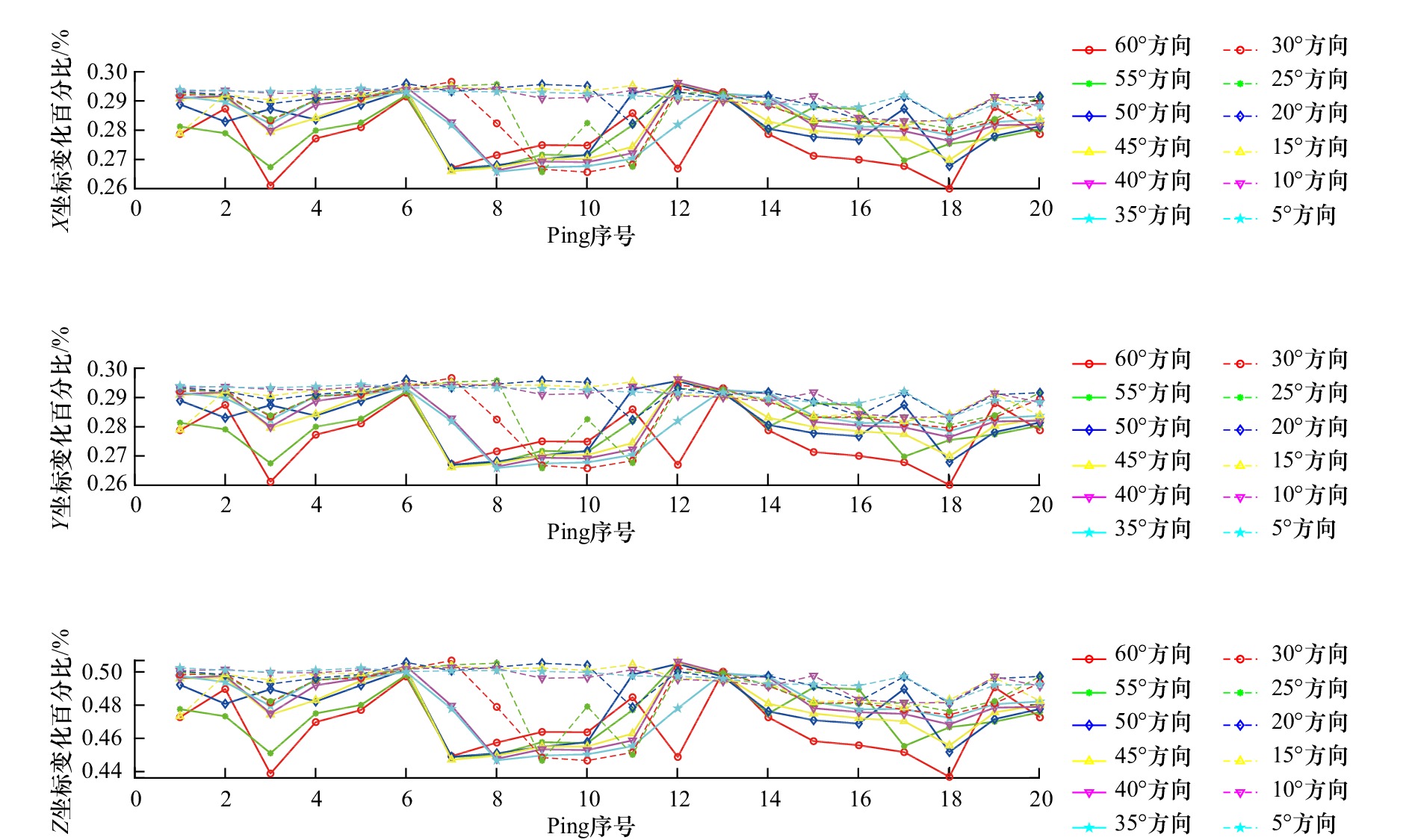
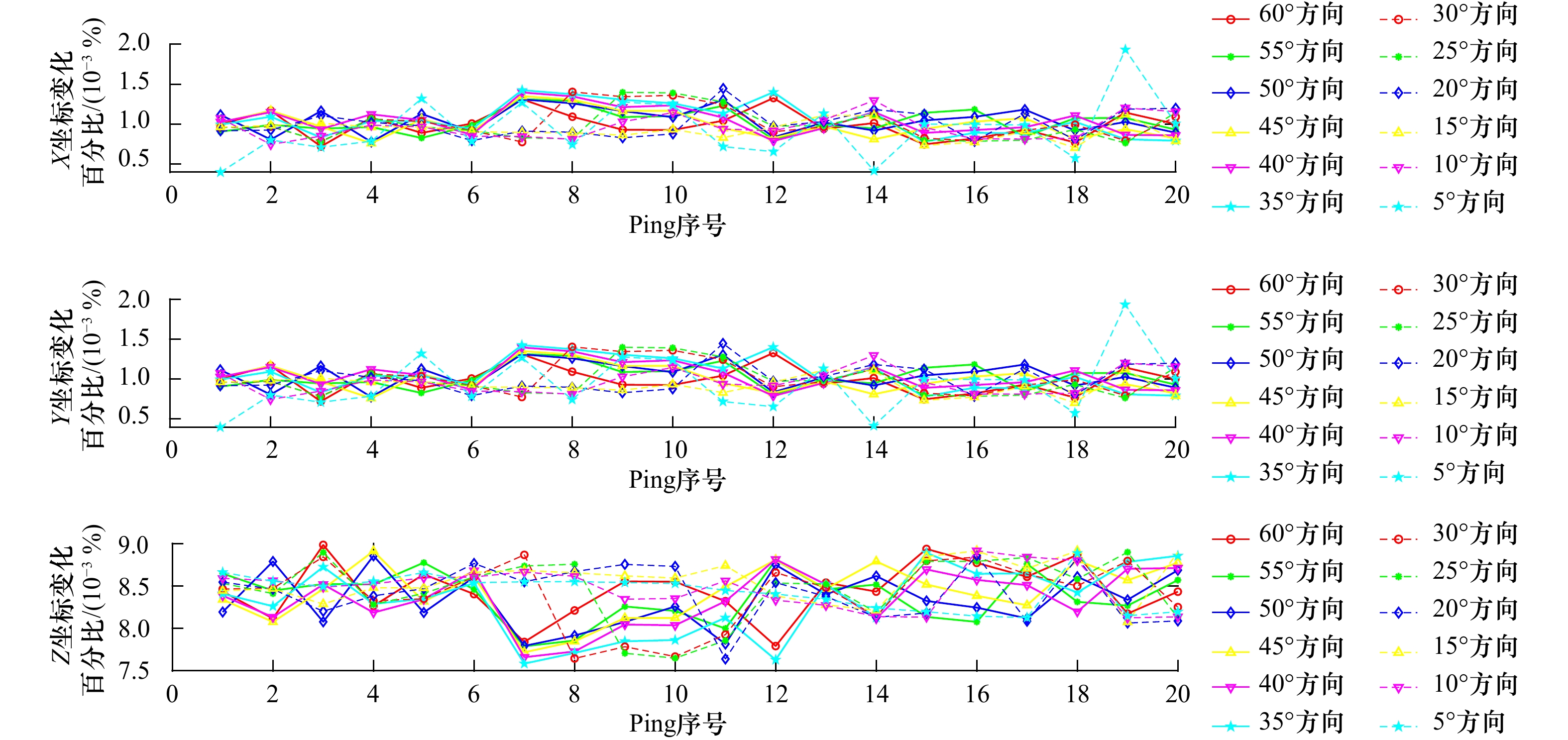
2023, 45(2): 130-138.
doi: 10.12284/hyxb2023007
Abstract:
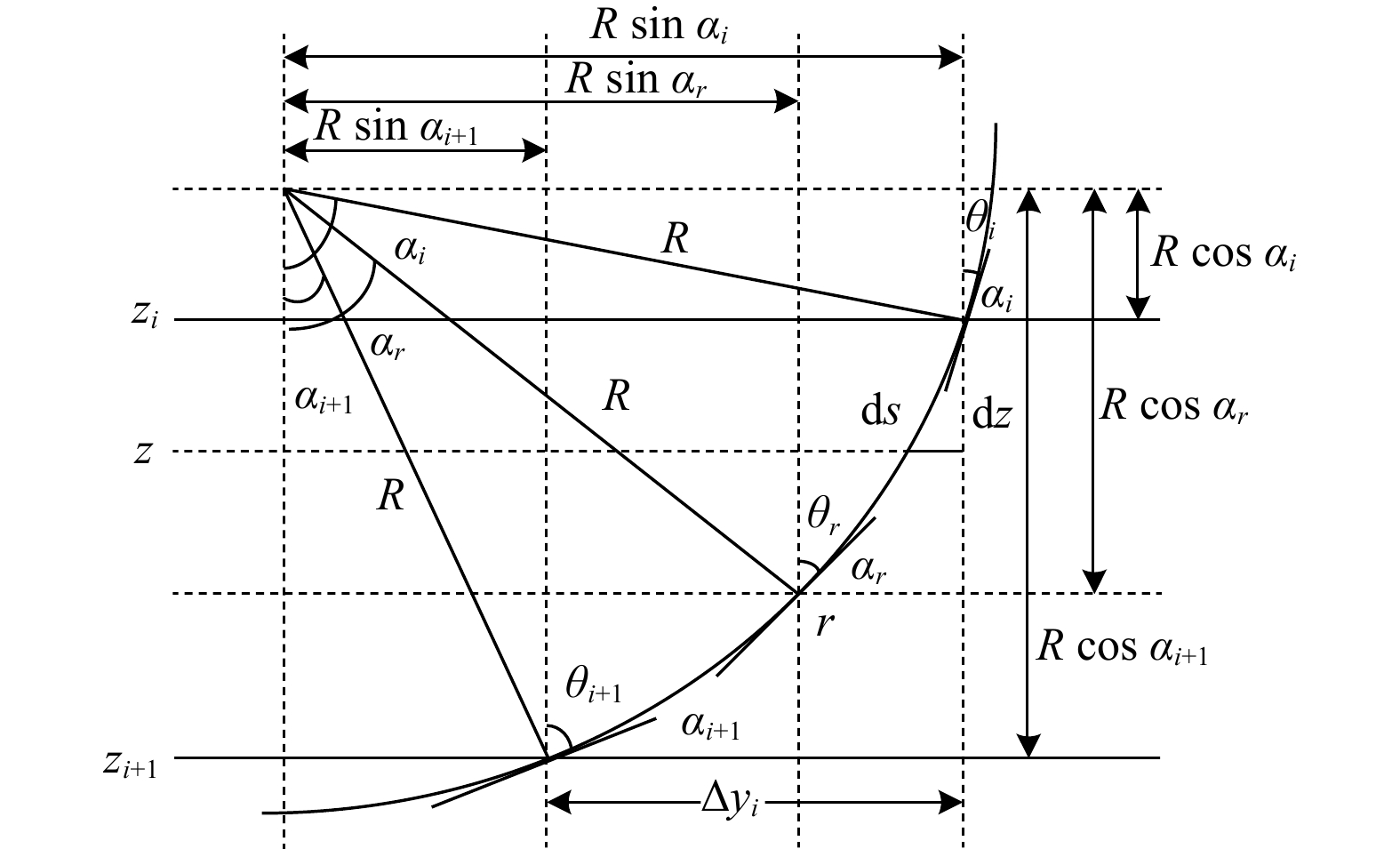
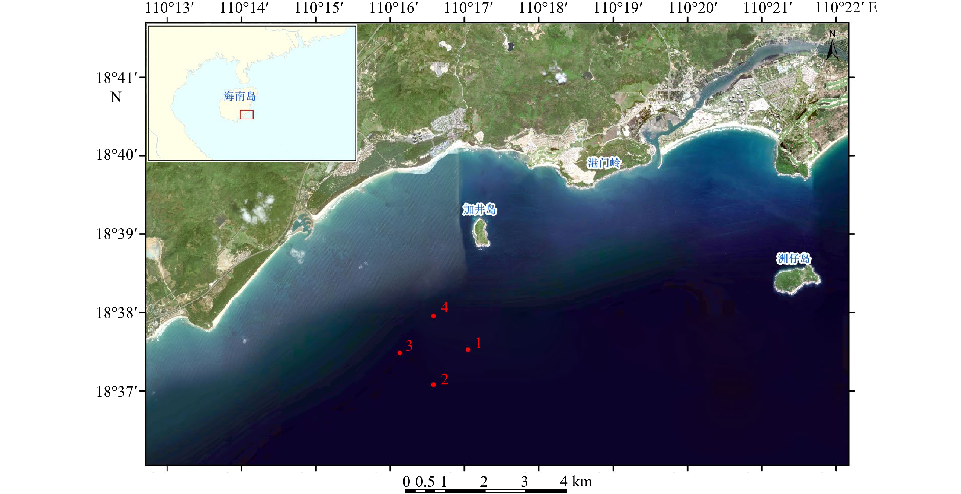
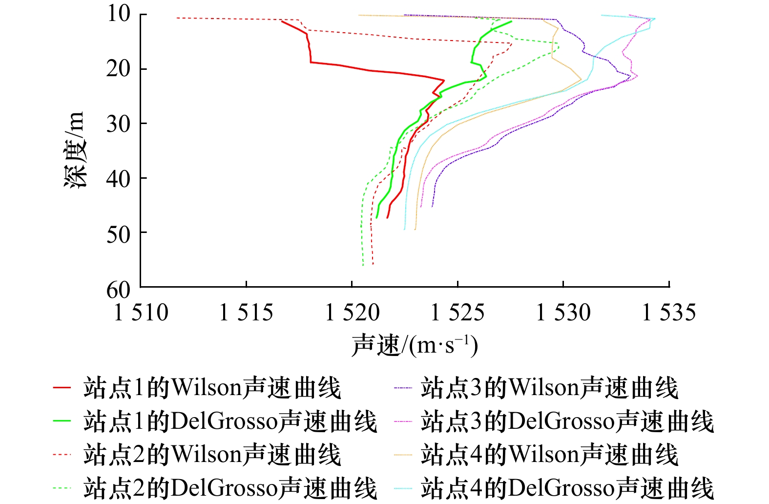
The multi-beam echo sounder is usually used in bathymetry activity, the accuracy of temperature, salinity and depth profile data play a very important role in the bathymetry. Unfortunately, those errors among the temperature, salinity and depth data were inevitably brought into the measurement. To analyze the influence of temperature, salinity and depth variations on beam footprint coordinates and quantify its influence value, then, on basis of the indirect measurement data of sound velocity profile, the empirical formula of sound velocity with high precision and strong adaptability were selected to deduce their error formula, and the error value of sound velocity caused by temperature, salinity and depth variation was calculated. On the basis of constant-gradient sound ray tracing model, the horizontal and vertical displacement error formulas of sound wave travel path were derived, and then the influence value of acoustic velocity error on beam footprint coordinates was calculated by combining with sound velocity profile. The experimental results show that temperature has the greatest influence on sound velocity, followed by salinity and depth. The variations of temperature, salinity and depth cause the Z-coordinate variation of the beam footprint to be larger than the X and Y coordinates, up to 0.6% of the depth before the change. The variation of three-dimensional coordinates caused by temperature and salinity decreases with the increase of incident angle, however, the variation of three-dimensional coordinates caused by depth hardly changes with the change of incident angle. The results of this paper can be used for reference to evaluate the accuracy of multi-beam bathymetry with temperature, salinity and depth error.
The multi-beam echo sounder is usually used in bathymetry activity, the accuracy of temperature, salinity and depth profile data play a very important role in the bathymetry. Unfortunately, those errors among the temperature, salinity and depth data were inevitably brought into the measurement. To analyze the influence of temperature, salinity and depth variations on beam footprint coordinates and quantify its influence value, then, on basis of the indirect measurement data of sound velocity profile, the empirical formula of sound velocity with high precision and strong adaptability were selected to deduce their error formula, and the error value of sound velocity caused by temperature, salinity and depth variation was calculated. On the basis of constant-gradient sound ray tracing model, the horizontal and vertical displacement error formulas of sound wave travel path were derived, and then the influence value of acoustic velocity error on beam footprint coordinates was calculated by combining with sound velocity profile. The experimental results show that temperature has the greatest influence on sound velocity, followed by salinity and depth. The variations of temperature, salinity and depth cause the Z-coordinate variation of the beam footprint to be larger than the X and Y coordinates, up to 0.6% of the depth before the change. The variation of three-dimensional coordinates caused by temperature and salinity decreases with the increase of incident angle, however, the variation of three-dimensional coordinates caused by depth hardly changes with the change of incident angle. The results of this paper can be used for reference to evaluate the accuracy of multi-beam bathymetry with temperature, salinity and depth error.


 Email alert
 RSS
RSS