


2022 Vol. 44, No. 10
Display Method:
2022, 44(10): 1-9.
doi: 10.12284/hyxb2022198
Abstract:
Estuarine flow is the fundamental driving of physical processes such as estuarine ecological environment, river evolution and material transport. Due to the runoff, tide, topography and meteorology, the estuarine flow presents a complex three-dimensional structure, including not only the residual flow induced by fresh water injection, but also the periodical tidal current, wind-driven flow, baroclinic flow and the residual flow caused by estuarine nonlinearity. In order to explore the composition and intra-tidal variation of estuarine flow, based on the field data in the Oujiang River Estuary, the estuarine flow is decomposed by principal component analysis (PCA) method, and the decomposition performance of PCA method for estuarine flow and high-frequency characteristics of baroclinic overtide are deeply discussed. The results show that PCA method can operate original data or standardized data in the study of estuarine flow structure. PCA method can decompose baroclinic components (estuarine gravitational circulation structure), but cannot separate barotropic components (runoff and tidal current). The coupled effect of runoff and tidal current is reflected in the score of principal components. The filter of principal components should employ conjoint judgment of flow structure and cumulative interpretation variance, rather than only cumulative interpretation variance. The estuarine baroclinic flow has clearly high-frequency characteristics, which approximates quarter-diurnal.
Estuarine flow is the fundamental driving of physical processes such as estuarine ecological environment, river evolution and material transport. Due to the runoff, tide, topography and meteorology, the estuarine flow presents a complex three-dimensional structure, including not only the residual flow induced by fresh water injection, but also the periodical tidal current, wind-driven flow, baroclinic flow and the residual flow caused by estuarine nonlinearity. In order to explore the composition and intra-tidal variation of estuarine flow, based on the field data in the Oujiang River Estuary, the estuarine flow is decomposed by principal component analysis (PCA) method, and the decomposition performance of PCA method for estuarine flow and high-frequency characteristics of baroclinic overtide are deeply discussed. The results show that PCA method can operate original data or standardized data in the study of estuarine flow structure. PCA method can decompose baroclinic components (estuarine gravitational circulation structure), but cannot separate barotropic components (runoff and tidal current). The coupled effect of runoff and tidal current is reflected in the score of principal components. The filter of principal components should employ conjoint judgment of flow structure and cumulative interpretation variance, rather than only cumulative interpretation variance. The estuarine baroclinic flow has clearly high-frequency characteristics, which approximates quarter-diurnal.


2022, 44(10): 10-19.
doi: 10.12284/hyxb2022184
Abstract:
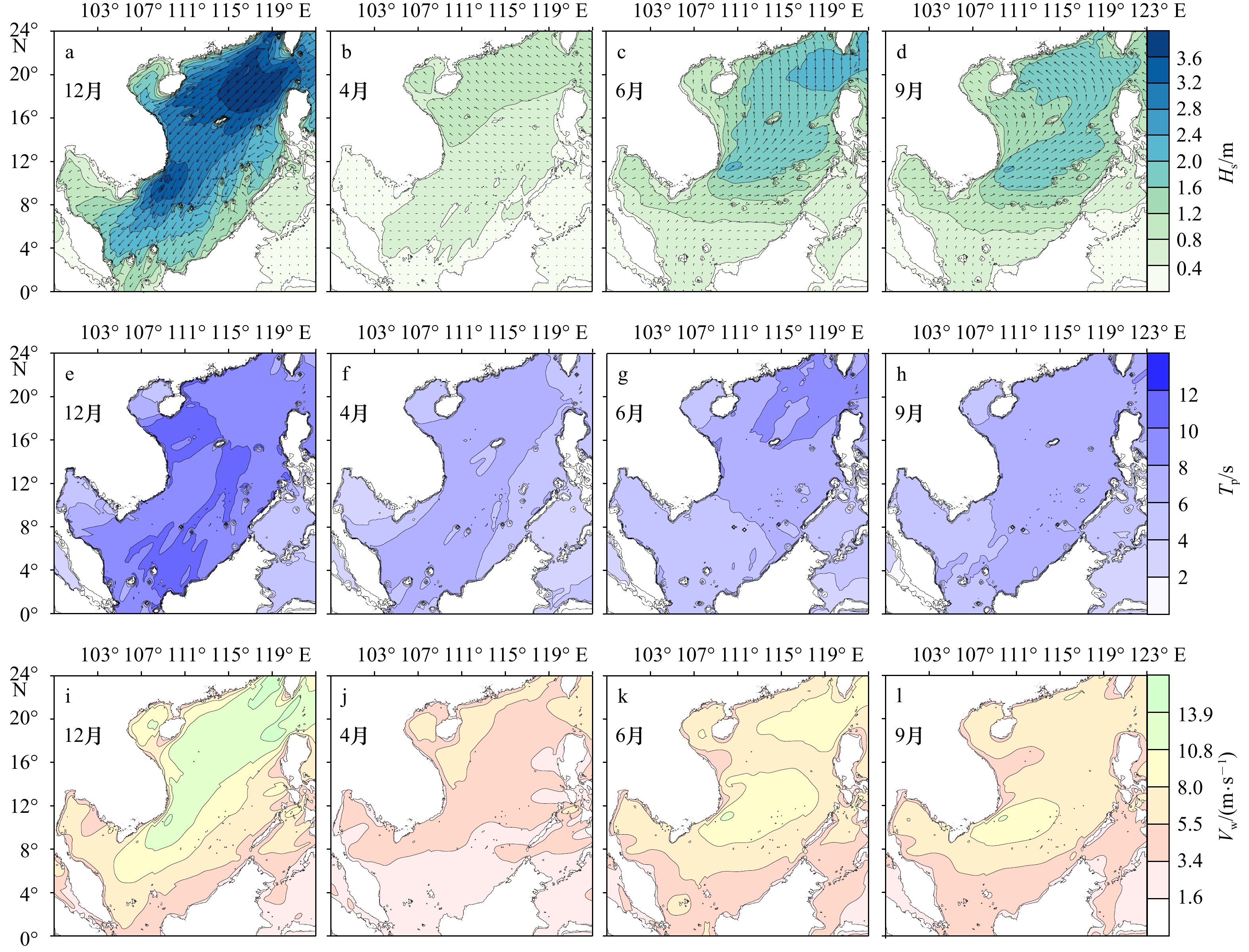
Driven by the reanalysis wind data NCEP CFSV2, the third-generation wave model SWAN is utilized in a self-nested grid system to simulate waves in the Beibu Gulf (BG), South China Sea (SCS) for a period of one year. The model accuracy is examined by comparing the numerical results with the Jason-2 satellite altimetry data and the near-shore buoy measurements. Based on the numerical simulations, the influence of spatial resolutions on model predication is evaluated, the seasonal characteristics of waves in the BG are analyzed, and the forcing contributions of local wind in BG and sea waves from SCS are discussed. The results show that: (1) Compared with the Jason-2 satellite data, the root-mean square bias (RMSB) and scatter index (SI) for significant wave height are approximately 0.4 m and 0.2, respectively. Compared with the near-shore buoy observations, the RMSB and SI for significant wave height are about 0.2 m and 0.4, respectively; the RMSB and SI for mean wave period are roughly 0.6 s and 0.2, respectively; and the RMSB for mean wave direction is around 30°. (2) The numerical model with the spatial resolution 12'×12' can predict reasonable results for the open sea area of BG, and the mean relative bias compared to the model results of 2'×2' is not exceeding 10%. (3) In the BG, the northeasterly waves prevail in winter monsoon, the southerly waves reign in summer monsoon, and the southeast waves predominate during the periods of monsoon transition (MT). Waves are stronger in monsoons than MTs, up to the strongest in winter monsoon and down to the weakest when winter goes to summer. (4) The driving contribution of local wind to waves in the BG increases gradually from the bay mouth to the inner bay, and the contribution is stronger in monsoons than MTs. The driving contribution of sea waves from SCS gradually weakens from the bay mouth to the inner bay, and the contribution is weaker during monsoons than MTs. In the middle and northern parts of BG, waves are mainly controlled by local wind. In the water areas to the south and east of Hainan Island, waves are mainly dominated by sea waves from SCS. While in the areas to the southwest of Hainan Island, waves are jointly affected by the both factors.
Driven by the reanalysis wind data NCEP CFSV2, the third-generation wave model SWAN is utilized in a self-nested grid system to simulate waves in the Beibu Gulf (BG), South China Sea (SCS) for a period of one year. The model accuracy is examined by comparing the numerical results with the Jason-2 satellite altimetry data and the near-shore buoy measurements. Based on the numerical simulations, the influence of spatial resolutions on model predication is evaluated, the seasonal characteristics of waves in the BG are analyzed, and the forcing contributions of local wind in BG and sea waves from SCS are discussed. The results show that: (1) Compared with the Jason-2 satellite data, the root-mean square bias (RMSB) and scatter index (SI) for significant wave height are approximately 0.4 m and 0.2, respectively. Compared with the near-shore buoy observations, the RMSB and SI for significant wave height are about 0.2 m and 0.4, respectively; the RMSB and SI for mean wave period are roughly 0.6 s and 0.2, respectively; and the RMSB for mean wave direction is around 30°. (2) The numerical model with the spatial resolution 12'×12' can predict reasonable results for the open sea area of BG, and the mean relative bias compared to the model results of 2'×2' is not exceeding 10%. (3) In the BG, the northeasterly waves prevail in winter monsoon, the southerly waves reign in summer monsoon, and the southeast waves predominate during the periods of monsoon transition (MT). Waves are stronger in monsoons than MTs, up to the strongest in winter monsoon and down to the weakest when winter goes to summer. (4) The driving contribution of local wind to waves in the BG increases gradually from the bay mouth to the inner bay, and the contribution is stronger in monsoons than MTs. The driving contribution of sea waves from SCS gradually weakens from the bay mouth to the inner bay, and the contribution is weaker during monsoons than MTs. In the middle and northern parts of BG, waves are mainly controlled by local wind. In the water areas to the south and east of Hainan Island, waves are mainly dominated by sea waves from SCS. While in the areas to the southwest of Hainan Island, waves are jointly affected by the both factors.


2022, 44(10): 20-34.
doi: 10.12284/hyxb2022200
Abstract:
Aiming at two types of typhoon field parameters used in parametric typhoon wind field model, such as radius to maximum wind speed\begin{document}${R}_{{\rm{max}}}$\end{document} ![]()
![]()
\begin{document}$(B)$\end{document} ![]()
![]()
\begin{document}${R}_{{\rm{max}}}$\end{document} ![]()
![]()
\begin{document}$ B $\end{document} ![]()
![]()
Aiming at two types of typhoon field parameters used in parametric typhoon wind field model, such as radius to maximum wind speed


2022, 44(10): 35-48.
doi: 10.12284/hyxb2022202
Abstract:
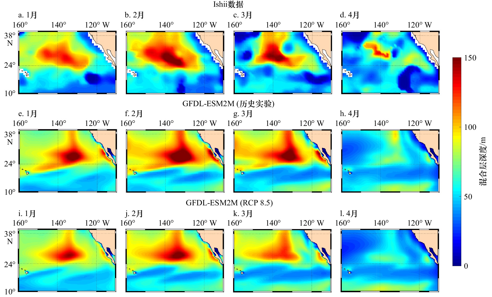
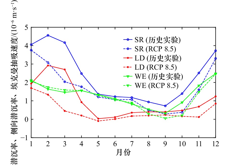
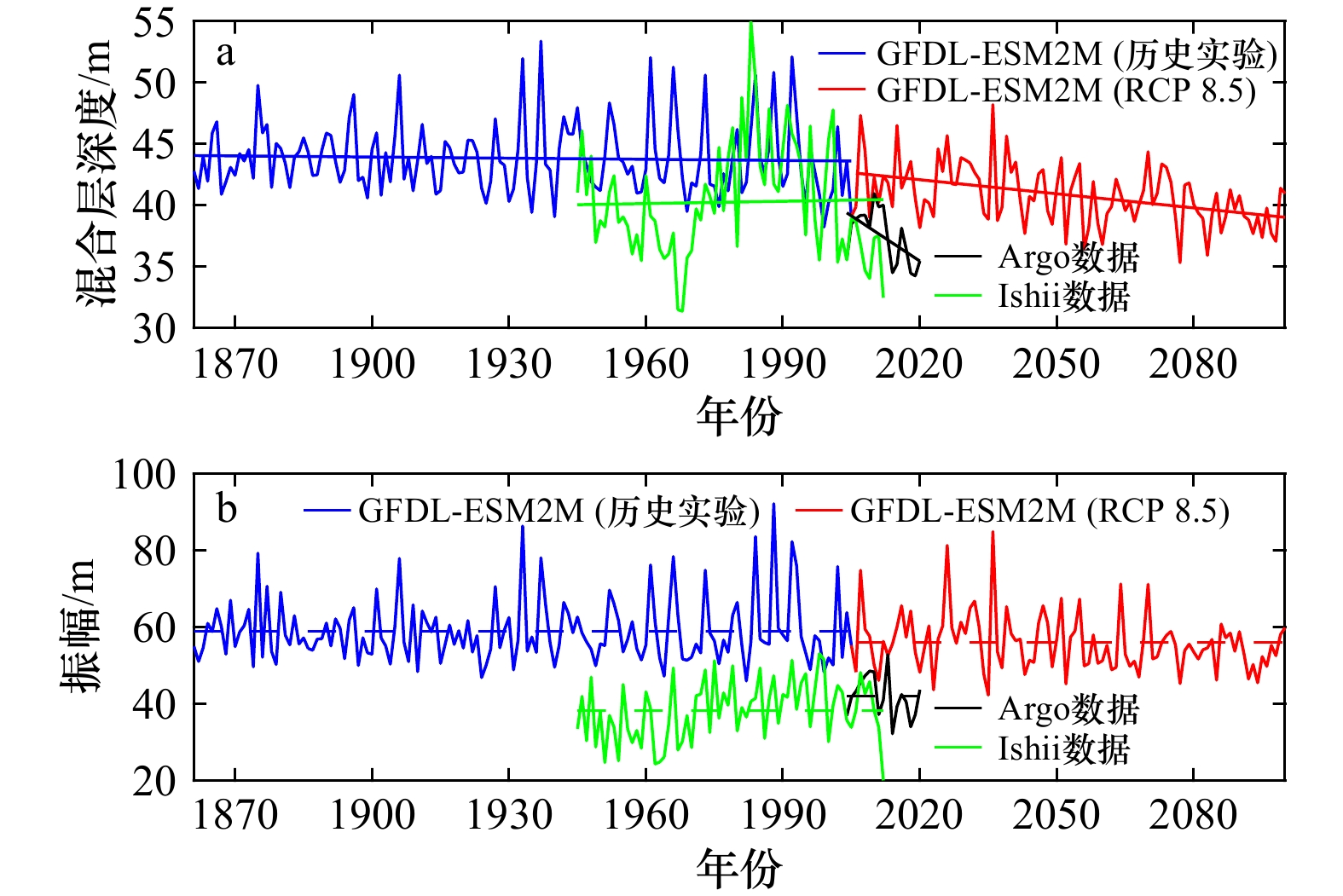
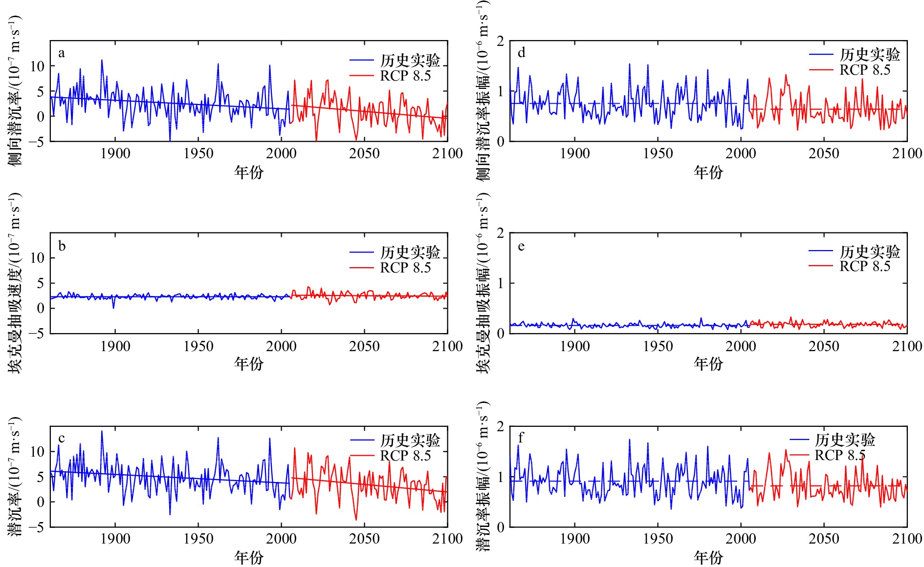
Based on the Earth System Model (ESM2M) of the Coupled Model Intercomparison Project 5 (CMIP5), combined with Argo observation data and the reanalysis dataset compiled by Ishii et al., this paper presents the seasonal variation characteristics of mixed layer depth (MLD) and subduction process in the subtropical Northeast Pacific Ocean (10°−40°N, 110°−160°W) under the present climate background and extreme enhancement of radiative forcing are presented, to study its response to global warming. Under the current climate background, both of MLD and subduction rate reach their maximum values in winter. The main contribution items of subduction rate have significant seasonal variation. From January to May, the subduction rate is mainly controlled by the change of lateral induction rate, while from June to December, the main mechanism is the change of Ekman pumping velocity controlled by wind stress curl. After global warming, the main control elements of seasonal signals remain unchanged. However, under the influences of wind stress curl and other factors, the MLD in each season decreased and the range of the core maximum region shrinks. As the decrease in winter is much larger than that in summer, the seasonal fluctuation range (amplitude) of MLD is significantly smaller. In the long run, MLD shows a trend of continuous shallower, and the weakening of MLD front caused by the weakening of its spatial non-uniformity is the key to control the weakening of lateral induction rate and eventually lead to the weakening of the subduction rate. Since the seasonal variation signal of Ekman pumping velocity has little response to global warming, subduction rate is most strongly affected in winter. The results show that the contribution proportion of the two key factors to the subduction rate changes with the seasons: when the MLD front is strong in winter, the influence of the lateral induction rate will be significantly enhanced. The different variations of the two factors before and after global warming will significantly change the seasonal amplitude of the subduction rate, which may have a profound impact on the formation and transport of mode water in the region.
Based on the Earth System Model (ESM2M) of the Coupled Model Intercomparison Project 5 (CMIP5), combined with Argo observation data and the reanalysis dataset compiled by Ishii et al., this paper presents the seasonal variation characteristics of mixed layer depth (MLD) and subduction process in the subtropical Northeast Pacific Ocean (10°−40°N, 110°−160°W) under the present climate background and extreme enhancement of radiative forcing are presented, to study its response to global warming. Under the current climate background, both of MLD and subduction rate reach their maximum values in winter. The main contribution items of subduction rate have significant seasonal variation. From January to May, the subduction rate is mainly controlled by the change of lateral induction rate, while from June to December, the main mechanism is the change of Ekman pumping velocity controlled by wind stress curl. After global warming, the main control elements of seasonal signals remain unchanged. However, under the influences of wind stress curl and other factors, the MLD in each season decreased and the range of the core maximum region shrinks. As the decrease in winter is much larger than that in summer, the seasonal fluctuation range (amplitude) of MLD is significantly smaller. In the long run, MLD shows a trend of continuous shallower, and the weakening of MLD front caused by the weakening of its spatial non-uniformity is the key to control the weakening of lateral induction rate and eventually lead to the weakening of the subduction rate. Since the seasonal variation signal of Ekman pumping velocity has little response to global warming, subduction rate is most strongly affected in winter. The results show that the contribution proportion of the two key factors to the subduction rate changes with the seasons: when the MLD front is strong in winter, the influence of the lateral induction rate will be significantly enhanced. The different variations of the two factors before and after global warming will significantly change the seasonal amplitude of the subduction rate, which may have a profound impact on the formation and transport of mode water in the region.


2022, 44(10): 49-62.
doi: 10.12284/hyxb2022178
Abstract:
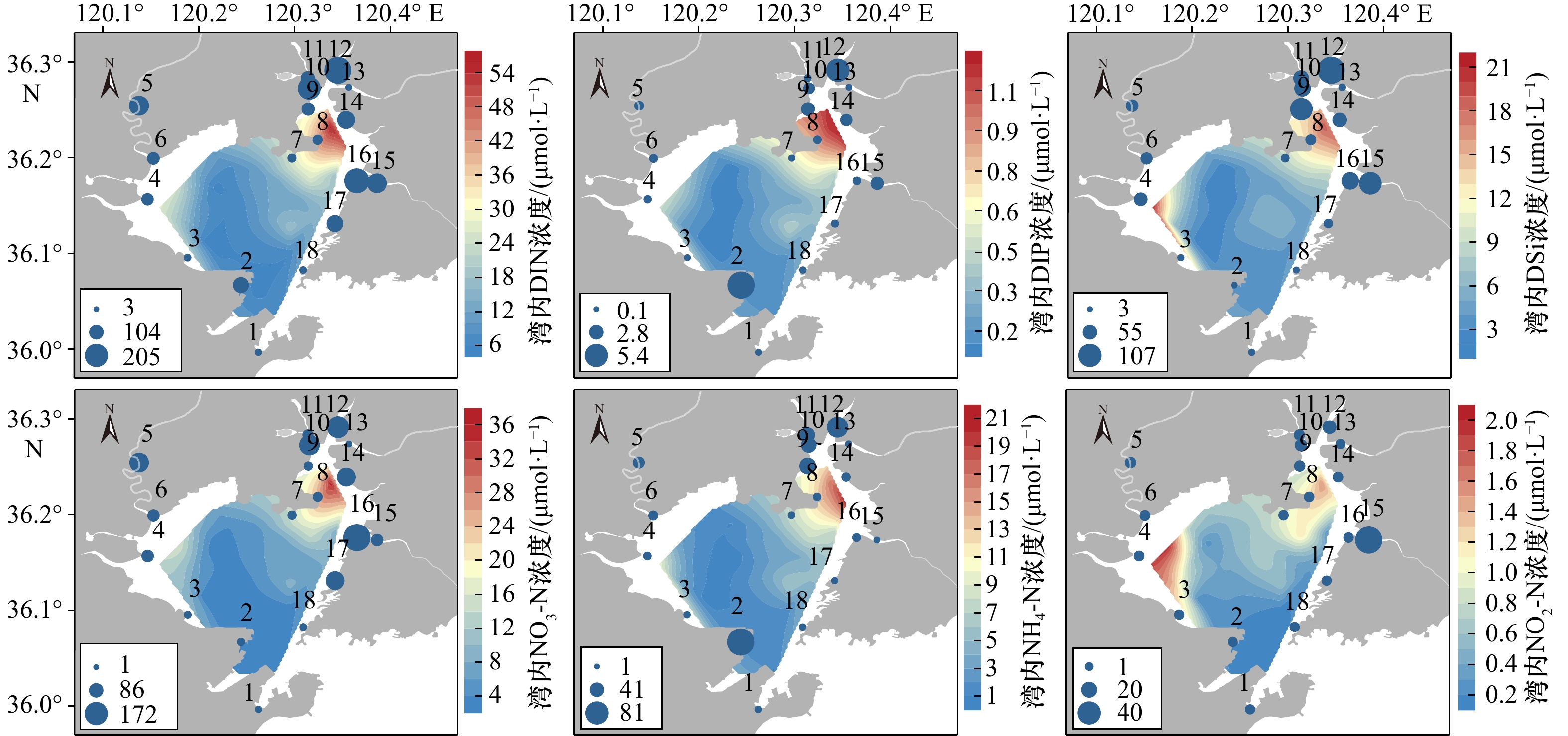
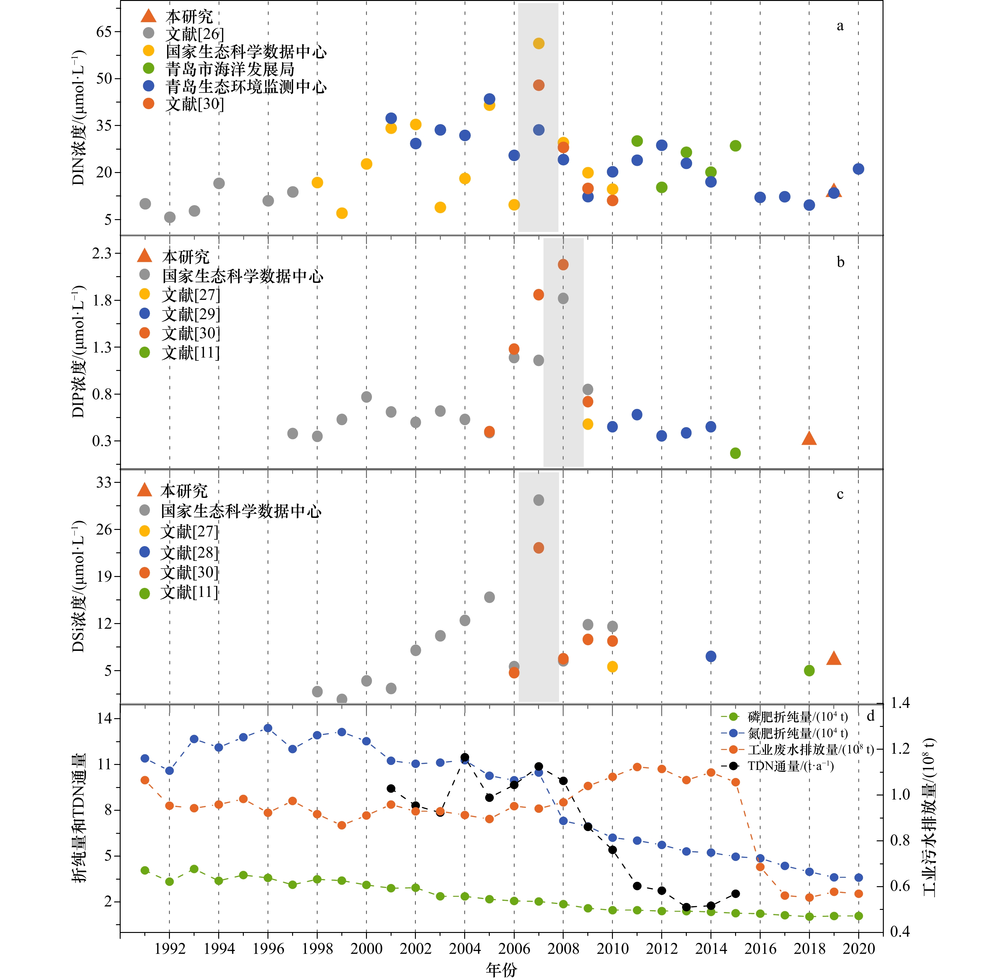
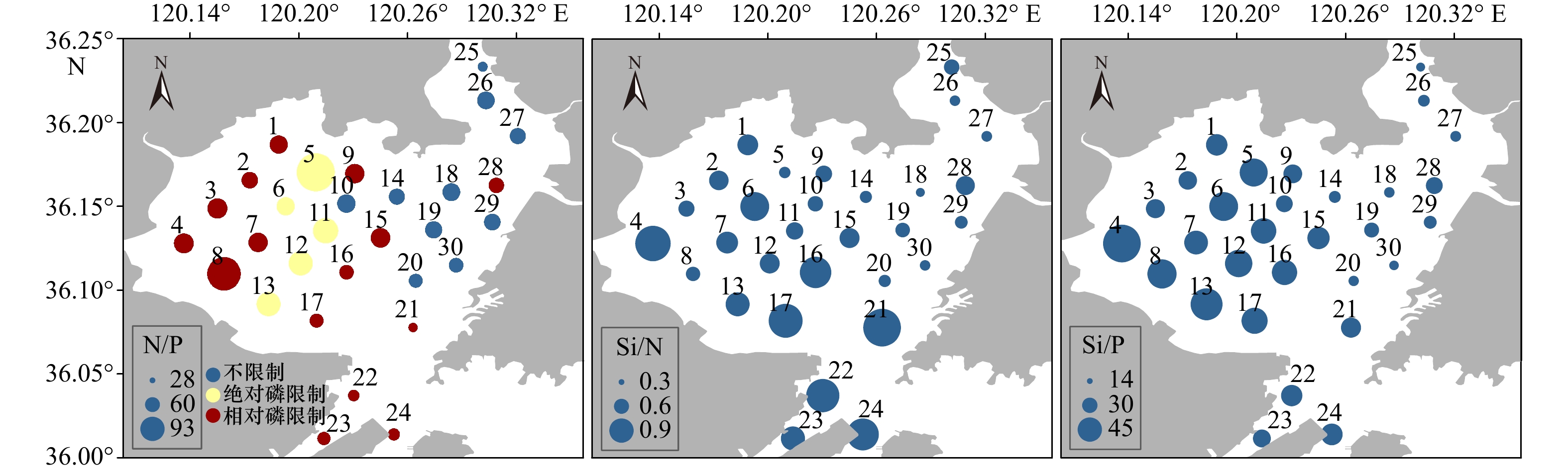
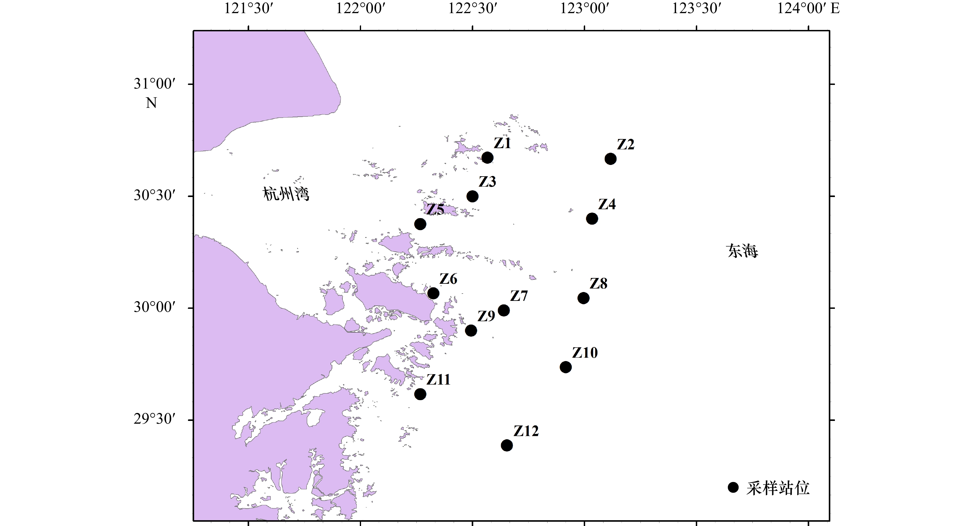
Seawater and surface sediment samples at 30 stations in the Jiaozhou Bay (JZB) and river water and coastal water samples at 18 stations along the JZB were collected in August 2019 and May 2021, respectively. Dissolved inorganic nutrient concentrations and structure in the water and the contents of total organic carbon (TOC), total nitrogen (TN), total phosphorus (TP), biogenic silica (BSi), and stable isotopes of carbon and nitrogen (δ13C, δ15N) in surface sediments were analyzed to clarify the present nutritional environment of seawater and surface sediment and its main influencing factors in the JZB. The results show that the spatial distribution of dissolved inorganic nitrogen (DIN), dissolved inorganic phosphorus (DIP), and dissolved silicate (DSi) in seawater is consistent with that in the coastal water of JZB. The high values that occur northeast of the bay are mainly caused by river input and sewage discharge, and the low values mainly occur at the center and bay mouth. Combined with the analysis of historical data, we found that the nutrient concentrations of JZB in summer continued to rise from 1990 to 2008 and then declined since 2006 because of the declining nutrient loadings related to the implementation of total pollutant load control management and freshwater loadings from surrounding rivers. The decreased nutrient loadings were mainly found in rivers such as the Dagu River, causing the disappearance of high concentrations in the western region after 2010. The phosphorus limitation accelerated after 2000 as a result of the imbalanced input of nitrogen and phosphorus. The high values of TOC, TN, and TP in the surface sediments of JZB are concentrated along the northeast and east coasts, combined with BSi and water nutrient analysis, which is mainly caused by the river input and sewage discharge and the high primary productivity they bring. Sediment biogenic elements are well coupled with water column nutrients in spatial distribution. The adverse effect of coarse sediment grain size on the preservation of organic matter and the strong hydrodynamic effect of the bay mouth jointly lead to the low content of biogenic elements in the west, middle, and mouth of the bay. The δ13C and two-endmember mixing model show that the source of organic matter in the surface sediments of JZB is mainly marine-derived, accounting for an average of 64%. The eastern coast is obviously affected by terrestrial input. The spatial distribution of δ15N shows that the nitrogen in the surface sediment of JZB is jointly affected by mariculture and sewage discharge. The current situation of the water body and sediment nutrient environments shows that the control of sewage discharge from the northeast river and the coastal area is the key to the later pollution control of JZB.
Seawater and surface sediment samples at 30 stations in the Jiaozhou Bay (JZB) and river water and coastal water samples at 18 stations along the JZB were collected in August 2019 and May 2021, respectively. Dissolved inorganic nutrient concentrations and structure in the water and the contents of total organic carbon (TOC), total nitrogen (TN), total phosphorus (TP), biogenic silica (BSi), and stable isotopes of carbon and nitrogen (δ13C, δ15N) in surface sediments were analyzed to clarify the present nutritional environment of seawater and surface sediment and its main influencing factors in the JZB. The results show that the spatial distribution of dissolved inorganic nitrogen (DIN), dissolved inorganic phosphorus (DIP), and dissolved silicate (DSi) in seawater is consistent with that in the coastal water of JZB. The high values that occur northeast of the bay are mainly caused by river input and sewage discharge, and the low values mainly occur at the center and bay mouth. Combined with the analysis of historical data, we found that the nutrient concentrations of JZB in summer continued to rise from 1990 to 2008 and then declined since 2006 because of the declining nutrient loadings related to the implementation of total pollutant load control management and freshwater loadings from surrounding rivers. The decreased nutrient loadings were mainly found in rivers such as the Dagu River, causing the disappearance of high concentrations in the western region after 2010. The phosphorus limitation accelerated after 2000 as a result of the imbalanced input of nitrogen and phosphorus. The high values of TOC, TN, and TP in the surface sediments of JZB are concentrated along the northeast and east coasts, combined with BSi and water nutrient analysis, which is mainly caused by the river input and sewage discharge and the high primary productivity they bring. Sediment biogenic elements are well coupled with water column nutrients in spatial distribution. The adverse effect of coarse sediment grain size on the preservation of organic matter and the strong hydrodynamic effect of the bay mouth jointly lead to the low content of biogenic elements in the west, middle, and mouth of the bay. The δ13C and two-endmember mixing model show that the source of organic matter in the surface sediments of JZB is mainly marine-derived, accounting for an average of 64%. The eastern coast is obviously affected by terrestrial input. The spatial distribution of δ15N shows that the nitrogen in the surface sediment of JZB is jointly affected by mariculture and sewage discharge. The current situation of the water body and sediment nutrient environments shows that the control of sewage discharge from the northeast river and the coastal area is the key to the later pollution control of JZB.


2022, 44(10): 63-79.
doi: 10.12284/hyxb2022186
Abstract:
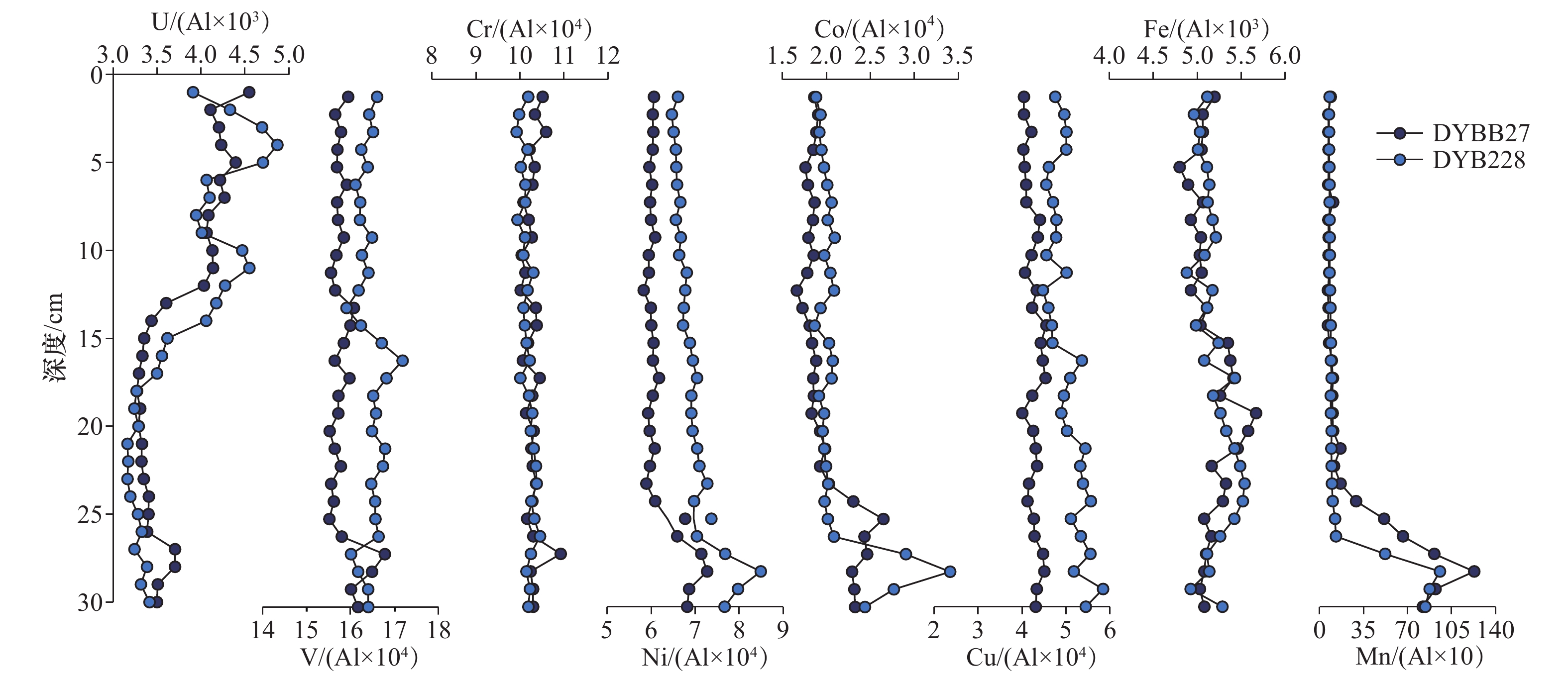
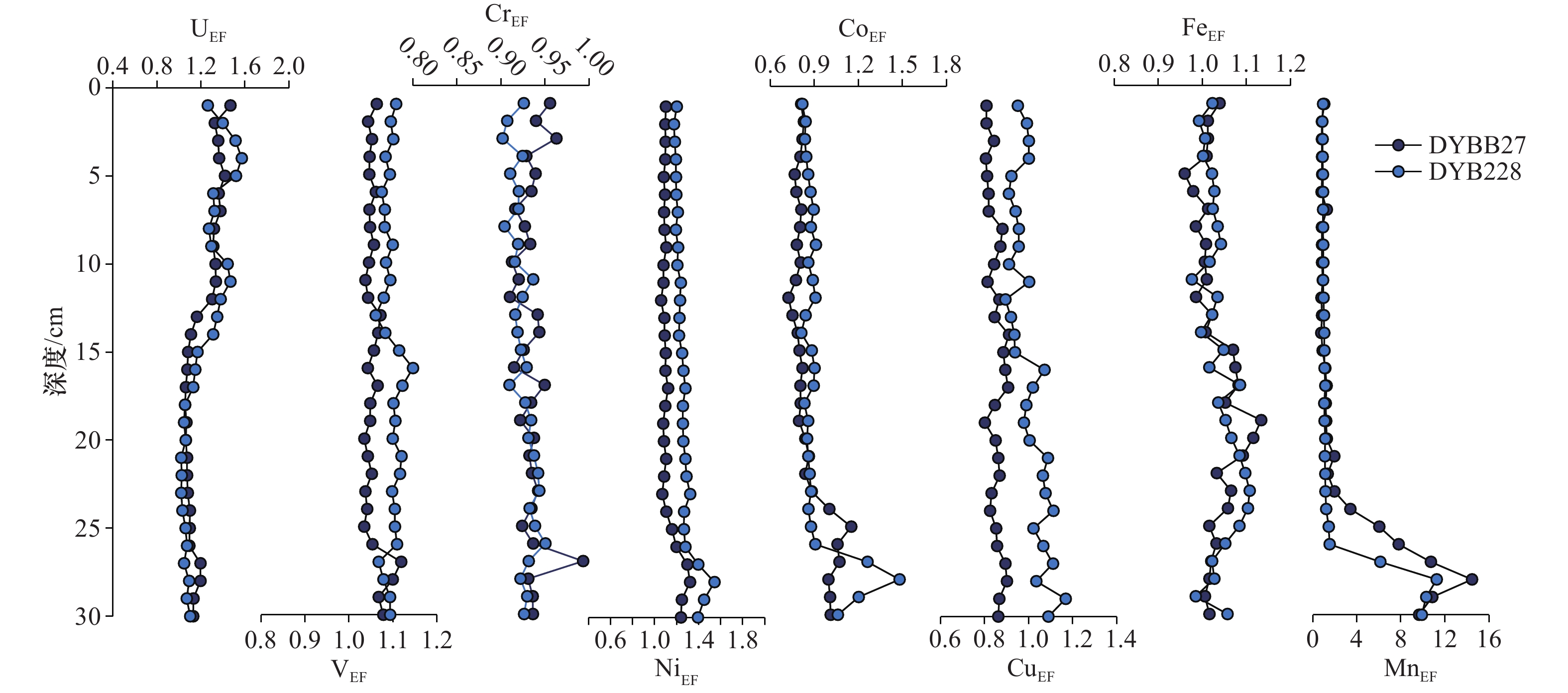
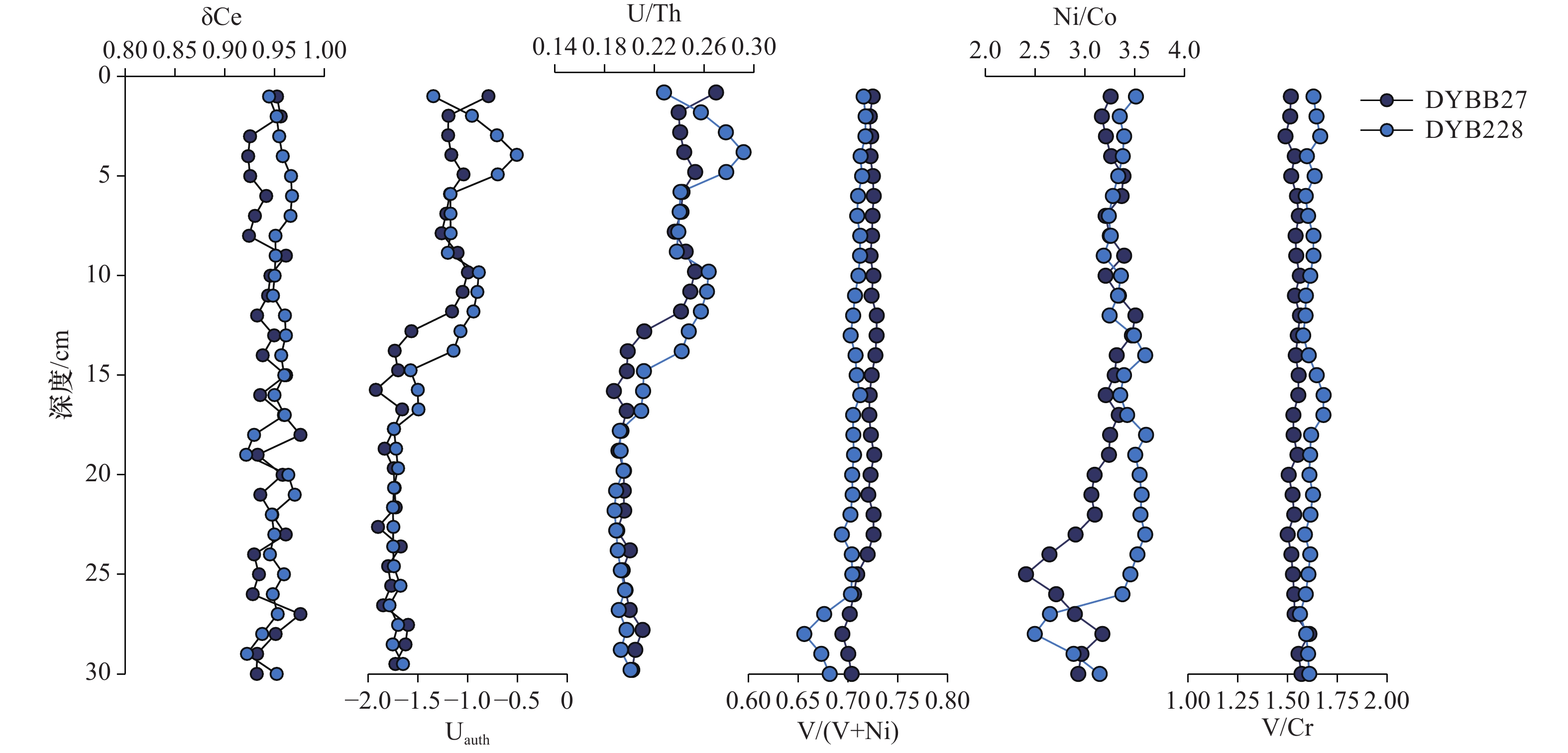
Changes in the content of redox sensitive elements (RSE) in sediments are good surrogate indicators for the redox environment of the overlying water. The RSE in the columnar sediments under complex environmental backgrounds through the grain size, total organic carbon and total nitrogen and its isotopes contents, and redox sensitive elements contents of the two columnar sediments (30 cm) in South Central Okinawa Trough are explored in this paper. And to explore the occurrence mechanism and environmental indication significance. The study found that in addition to the depletion of Cr in the columnar sediments, other RSEs showed different degrees of enrichment. The “grain size effect” has little effect on the RSE content of columnar sediments in the Okinawa Trough; analysis and judgment show that seawater surface productivity is the main factor affecting the redox environment of sediments, and RSE is achieved through the adsorption or desorption of Mn (hydrogen) oxides enrichment and loss. Indicators such as δCe, V/(V+Ni), Ni/Co and V/Cr indicate that the sediment is in an oxic-dysoxic water environment. The Mn element in the sediment diffuses upward in the form of Mn2+ through reduction, and is oxidized and enriched by oxygen-containing interstitial water at 25−30 cm to form a manganese peak. The 0−25 cm columnar sediment is in an oxic water column, and 25−30 cm is in a dysoxic water column.
Changes in the content of redox sensitive elements (RSE) in sediments are good surrogate indicators for the redox environment of the overlying water. The RSE in the columnar sediments under complex environmental backgrounds through the grain size, total organic carbon and total nitrogen and its isotopes contents, and redox sensitive elements contents of the two columnar sediments (30 cm) in South Central Okinawa Trough are explored in this paper. And to explore the occurrence mechanism and environmental indication significance. The study found that in addition to the depletion of Cr in the columnar sediments, other RSEs showed different degrees of enrichment. The “grain size effect” has little effect on the RSE content of columnar sediments in the Okinawa Trough; analysis and judgment show that seawater surface productivity is the main factor affecting the redox environment of sediments, and RSE is achieved through the adsorption or desorption of Mn (hydrogen) oxides enrichment and loss. Indicators such as δCe, V/(V+Ni), Ni/Co and V/Cr indicate that the sediment is in an oxic-dysoxic water environment. The Mn element in the sediment diffuses upward in the form of Mn2+ through reduction, and is oxidized and enriched by oxygen-containing interstitial water at 25−30 cm to form a manganese peak. The 0−25 cm columnar sediment is in an oxic water column, and 25−30 cm is in a dysoxic water column.


2022, 44(10): 182-192.
doi: 10.12284/hyxb2022166
Abstract:
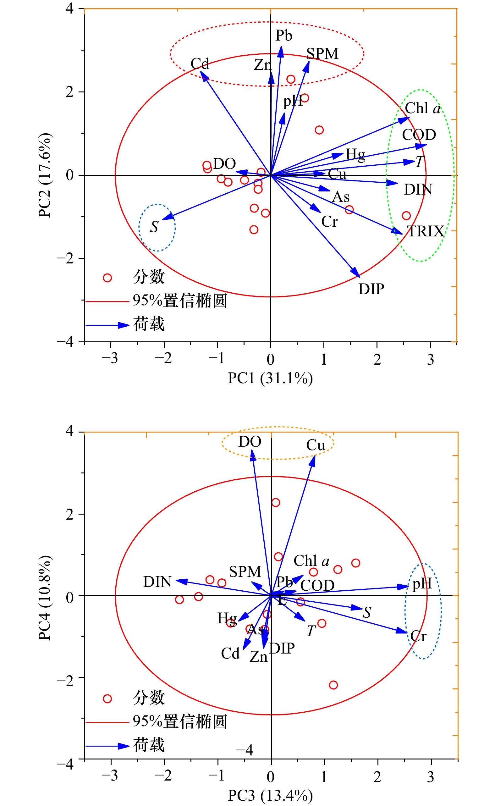
Characteristics of heavy metals in the Zhujiang River Estuary are mainly influenced by the interacting river-tide dynamics. Water and sediment samples were collected in the Zhujiang River Estuary and its adjacent zones in the summer of 2018. The present study aimed to investigate the estuarine behaviors (i.e., sedimentary, transportation, accumulation) of seven metals Hg, As, Zn, Cd, Pb, Cu, and Cr, which were co-influenced by the physicochemical properties in the estuary. The levels of heavy metals in sediments were higher than those dissolved in water. The heavy metals in sediments were more stable and the pollution was thus more serious. The results of Pearson correlation and principal component analysis showed that dissolved metals were more easily diluted and mixed, and the sediment metals were significantly influenced by the total organic carbon and redox. The metal partitioning between sediments and water was discussed as well in this study under the influence of estuarine dynamics, which indicated the phase exchange between multimedia in the estuary; Pb and Cr were more easily absorbed in the particulate particles, while Cd and Hg were intended to dissolve in water. The significant correlations between metals (e.g., Hg, Pb, and Zn) indicated the similar sources, and the principal component analysis was used to probe into the source contributions of heavy metals in sediments of the Zhujiang River Estuary, contributed mainly by industrial pollution, followed by agricultural pollution and atmospheric deposition. These findings will provide important information for the effective controls of heavy metal inputs and estuary management.
Characteristics of heavy metals in the Zhujiang River Estuary are mainly influenced by the interacting river-tide dynamics. Water and sediment samples were collected in the Zhujiang River Estuary and its adjacent zones in the summer of 2018. The present study aimed to investigate the estuarine behaviors (i.e., sedimentary, transportation, accumulation) of seven metals Hg, As, Zn, Cd, Pb, Cu, and Cr, which were co-influenced by the physicochemical properties in the estuary. The levels of heavy metals in sediments were higher than those dissolved in water. The heavy metals in sediments were more stable and the pollution was thus more serious. The results of Pearson correlation and principal component analysis showed that dissolved metals were more easily diluted and mixed, and the sediment metals were significantly influenced by the total organic carbon and redox. The metal partitioning between sediments and water was discussed as well in this study under the influence of estuarine dynamics, which indicated the phase exchange between multimedia in the estuary; Pb and Cr were more easily absorbed in the particulate particles, while Cd and Hg were intended to dissolve in water. The significant correlations between metals (e.g., Hg, Pb, and Zn) indicated the similar sources, and the principal component analysis was used to probe into the source contributions of heavy metals in sediments of the Zhujiang River Estuary, contributed mainly by industrial pollution, followed by agricultural pollution and atmospheric deposition. These findings will provide important information for the effective controls of heavy metal inputs and estuary management.


2022, 44(10): 80-89.
doi: 10.12284/hyxb2022116
Abstract:
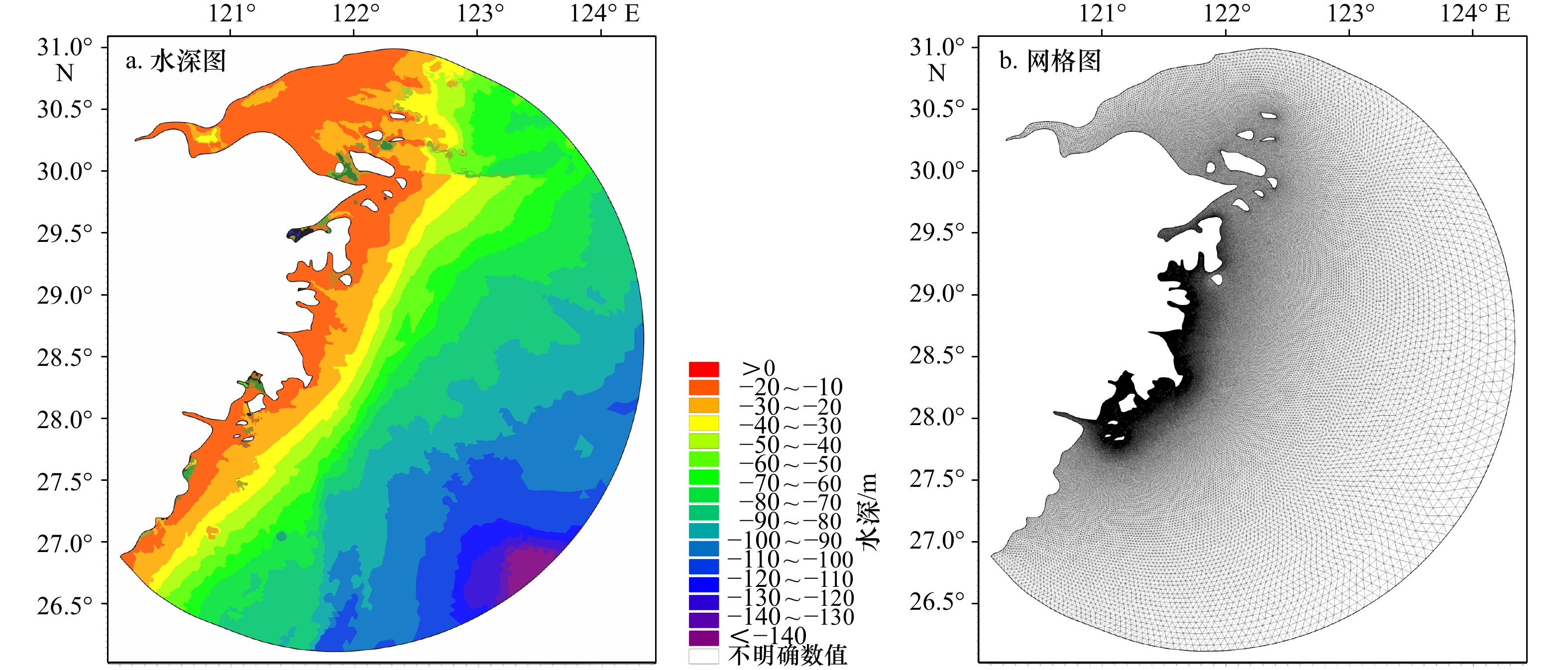
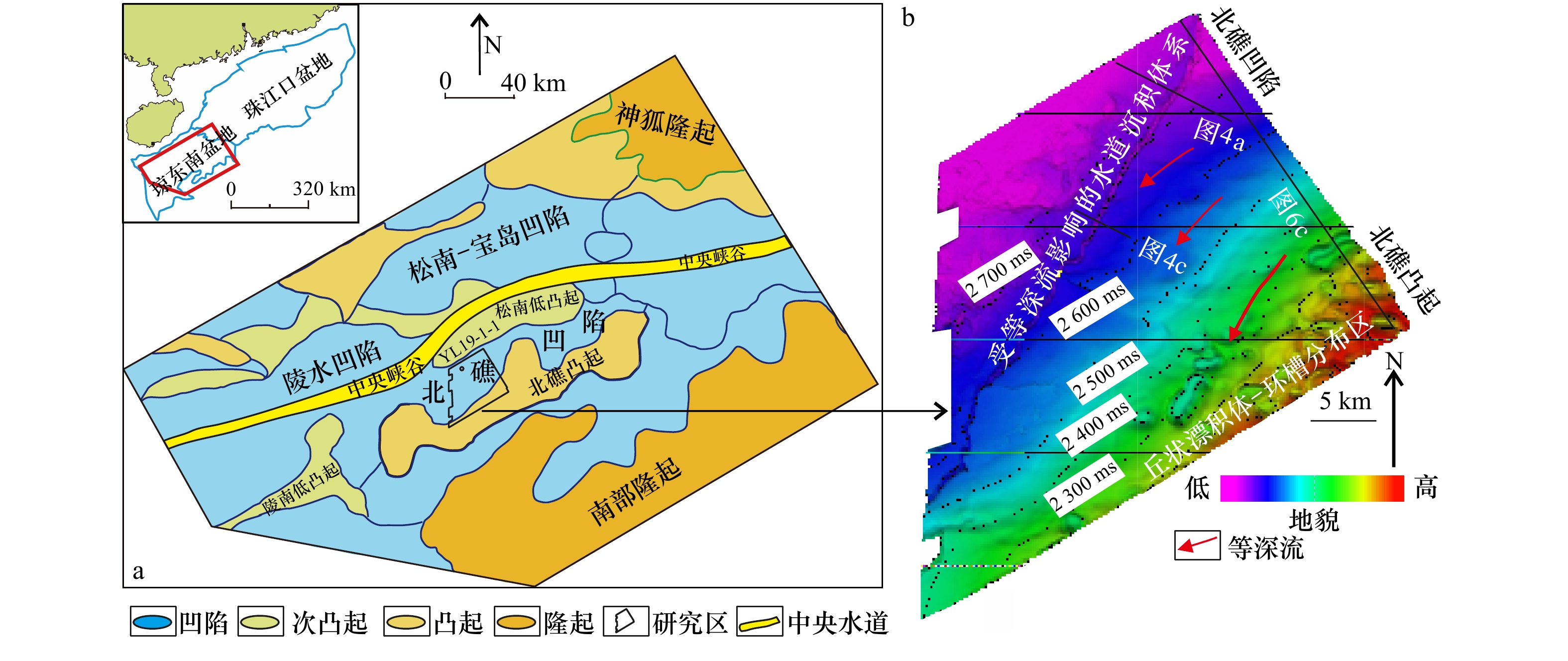
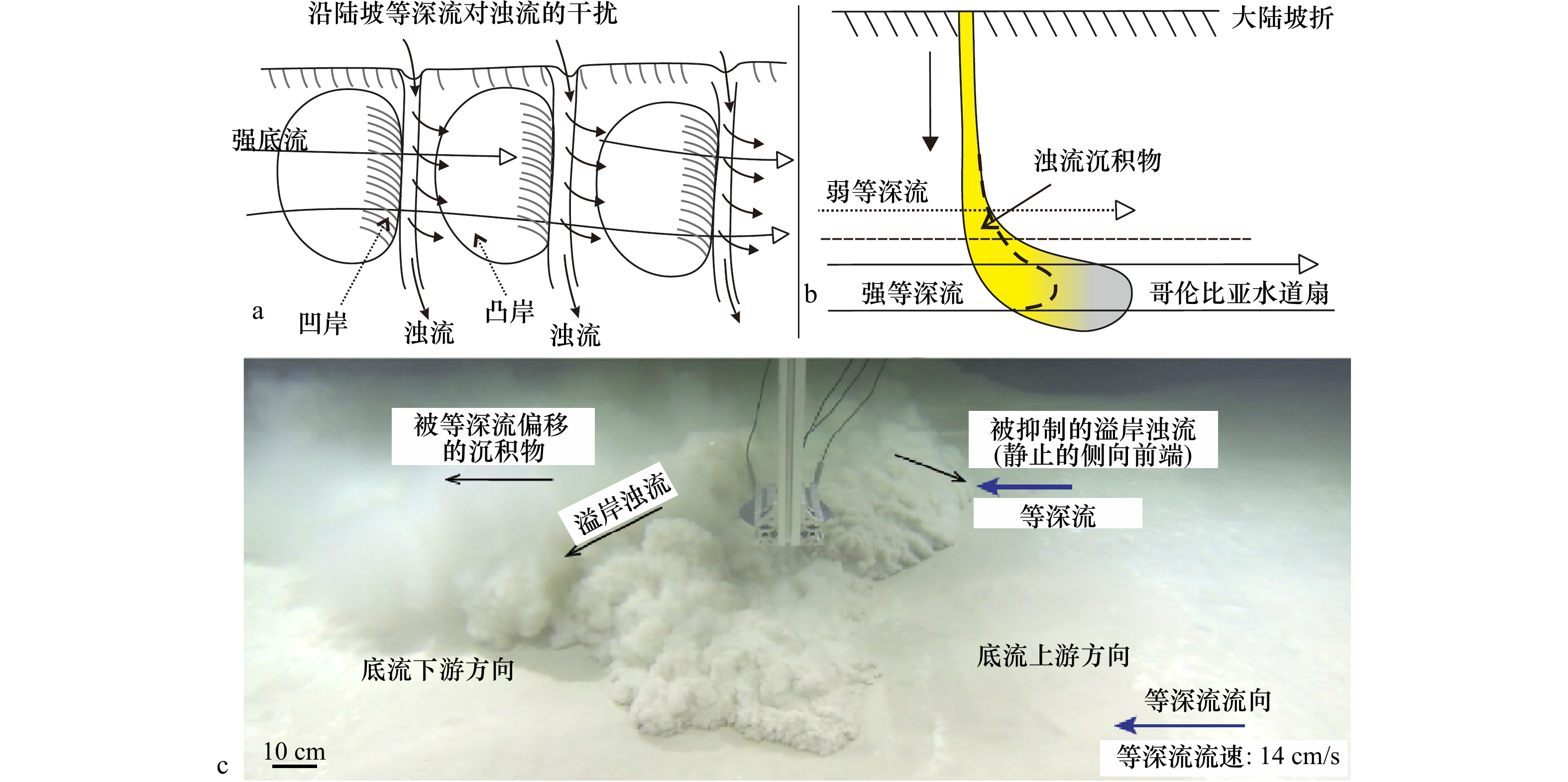
Depositional characteristics and process of deep-water channel sedimentary system influenced by contour currents is a current hotspot and new scientific issue in the study of deposits resulted from interaction between contour currents and turbidity flows. Using root mean square (RMS) attribute, coherenceseismic attribute, time structure and stratal slice, we focus on depositional characteristics and process of the channel sedimentary system in Pliocene strata in the Beijiao Sag, Qiongdongnan Basin. The results show that the channel sedimentary systems are divided into the early and late channel sedimentary systems. The depositonal units of the early system include channel, flake-shaped and fan-shaped overbank deposits. The units of the late systems incorporate: channel and flank-shaped overbank deposits. Fan-shaped overbank deposits are only distributed on the right side of the bend of the channel. Flake-shaped overbank deposits are only located on the left side of the channel. The channels are persistently oblique to the strike of the slope and they are symmetrical and characterized by vertical aggradations. Combined with the development features of mounded drifts and moats over the Beijiao uplift, it is inferred that the geometry of the channel sedimentary systems are mainly controlled by depositional products of the interaction between turbidity flows and contour currents. Contour currents flow across channels, forcing the upper part (low velocity and low density) of turbidity flows to deflect towards the left (downstream) side of channels and then form overspill currents. The direction of overspills is the same to that of contour currents, in this case, generating wide flake-shaped overbank deposits extending for several kmlometers. In the bend of channels, the direction of overspill currents is in contrast to that of contour currents, blocking or confining the range of the overbank deposits and then creating fan-shaped overbank deposits. This result are consistent with the previous results of flume-tank experiment.
Depositional characteristics and process of deep-water channel sedimentary system influenced by contour currents is a current hotspot and new scientific issue in the study of deposits resulted from interaction between contour currents and turbidity flows. Using root mean square (RMS) attribute, coherenceseismic attribute, time structure and stratal slice, we focus on depositional characteristics and process of the channel sedimentary system in Pliocene strata in the Beijiao Sag, Qiongdongnan Basin. The results show that the channel sedimentary systems are divided into the early and late channel sedimentary systems. The depositonal units of the early system include channel, flake-shaped and fan-shaped overbank deposits. The units of the late systems incorporate: channel and flank-shaped overbank deposits. Fan-shaped overbank deposits are only distributed on the right side of the bend of the channel. Flake-shaped overbank deposits are only located on the left side of the channel. The channels are persistently oblique to the strike of the slope and they are symmetrical and characterized by vertical aggradations. Combined with the development features of mounded drifts and moats over the Beijiao uplift, it is inferred that the geometry of the channel sedimentary systems are mainly controlled by depositional products of the interaction between turbidity flows and contour currents. Contour currents flow across channels, forcing the upper part (low velocity and low density) of turbidity flows to deflect towards the left (downstream) side of channels and then form overspill currents. The direction of overspills is the same to that of contour currents, in this case, generating wide flake-shaped overbank deposits extending for several kmlometers. In the bend of channels, the direction of overspill currents is in contrast to that of contour currents, blocking or confining the range of the overbank deposits and then creating fan-shaped overbank deposits. This result are consistent with the previous results of flume-tank experiment.


2022, 44(10): 90-99.
doi: 10.12284/hyxb2022188
Abstract:
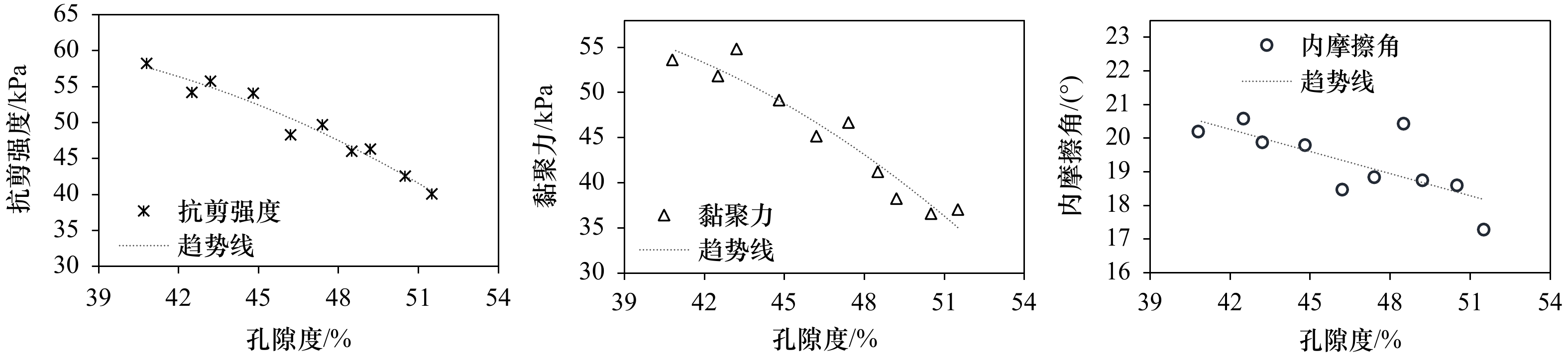
Marine sediments are characterized by soft texture and low strength, and their strength parameters are closely related to offshore platform pile placement and jacket installation, and are closely related to offshore operation safety. Conventional methods for obtaining strength parameters, such as drilling and cone penetration test, have high cost, few sampling points, and great disturbance to the soil. Therefore, it is of great significance to predict the strength parameters of marine sediments with easily accessible acoustic data. Based on the acoustic propagation theories such as Wood equation, Biot-Stoll model and Dvorkin equivalent medium model, the theoretical P-wave velocity under different physical parameter (density, porosity) gradients was calculated. Combined with the indoor simulated stratum acoustic experiment, the variation characteristics of the calculated and measured sound velocity were compared, and the relationship model between sound velocity and physical parameter was established. The relationship between soil physical parameter and shear strength, cohesive force and other parameters was revealed based on laboratory geotechnical test, and the relationship model between soil physical parameter and strength parameters was established. A prediction model for strength parameters of marine sediments based on acoustic characteristics was established by using physical parameters as bridge. This model not only avoids the problem of water loss disturbance of in-situ sampled soil, but also makes up for the limitation of empirical formula. It has universality and accuracy, and can effectively improve the precision of strength parameters of soil in unsampled areas, improve economic benefits, and play a theoretical guiding role in shallow exploration and development.
Marine sediments are characterized by soft texture and low strength, and their strength parameters are closely related to offshore platform pile placement and jacket installation, and are closely related to offshore operation safety. Conventional methods for obtaining strength parameters, such as drilling and cone penetration test, have high cost, few sampling points, and great disturbance to the soil. Therefore, it is of great significance to predict the strength parameters of marine sediments with easily accessible acoustic data. Based on the acoustic propagation theories such as Wood equation, Biot-Stoll model and Dvorkin equivalent medium model, the theoretical P-wave velocity under different physical parameter (density, porosity) gradients was calculated. Combined with the indoor simulated stratum acoustic experiment, the variation characteristics of the calculated and measured sound velocity were compared, and the relationship model between sound velocity and physical parameter was established. The relationship between soil physical parameter and shear strength, cohesive force and other parameters was revealed based on laboratory geotechnical test, and the relationship model between soil physical parameter and strength parameters was established. A prediction model for strength parameters of marine sediments based on acoustic characteristics was established by using physical parameters as bridge. This model not only avoids the problem of water loss disturbance of in-situ sampled soil, but also makes up for the limitation of empirical formula. It has universality and accuracy, and can effectively improve the precision of strength parameters of soil in unsampled areas, improve economic benefits, and play a theoretical guiding role in shallow exploration and development.


2022, 44(10): 100-108.
doi: 10.12284/hyxb2022180
Abstract:
Swordfish (Xiphias gladius) is a highly migratory fish whose habitat suitability is significantly influenced by the marine environment, and the prediction of its habitat using changes in the marine environment is of great scientific importance. In this study, we used the catch information of swordfish in the Chinese Indian Ocean Longline Fisheries Observer Data from 2017 to 2019 as species occurrence data, combined with the environmental data in the western Indian Ocean waters, including sea surface temperature (SST), sea surface height (SSH), chlorophyll a (Chl a) concentration, mixed layer depth (MLD), and sea surface salinity (SSS), the habitat suitability distribution of swordfish in the western Indian Ocean is simulated by using a maximum entropy model (MaxEnt). Model results show that: (1) the model has very high accuracy in simulating the habitat suitability distribution of swordfish in the western Indian Ocean, with AUC values greater than 0.9 in all seasons, and can be used to simulate the potential habitat suitability distribution of swordfish; (2) changes in the distribution of suitable habitat for swordfish in the study area are generally consistent with changes in the actual operational location, and the distribution of areas with high habitat suitability for swordfish is more concentrated in both the dry and rainy seasons, but the distribution range is greater in the wet season than in the dry season; (3) SST, SSS and MLD are important environmental factors affecting the habitat suitability distribution of swordfish in the western Indian Ocean. The optimum ranges of SST, SSS and MLD in the dry and rainy seasons are 25.8−31.6°C, 34.4−35.9 and 0.1−24.9 m, and 25.6−30.5°C, 34.8−36.4 and 13.1−54.1 m, respectively. The results of the study provide essential reference information for the sustainable use and scientific management of swordfish populations in the western Indian Ocean.
Swordfish (Xiphias gladius) is a highly migratory fish whose habitat suitability is significantly influenced by the marine environment, and the prediction of its habitat using changes in the marine environment is of great scientific importance. In this study, we used the catch information of swordfish in the Chinese Indian Ocean Longline Fisheries Observer Data from 2017 to 2019 as species occurrence data, combined with the environmental data in the western Indian Ocean waters, including sea surface temperature (SST), sea surface height (SSH), chlorophyll a (Chl a) concentration, mixed layer depth (MLD), and sea surface salinity (SSS), the habitat suitability distribution of swordfish in the western Indian Ocean is simulated by using a maximum entropy model (MaxEnt). Model results show that: (1) the model has very high accuracy in simulating the habitat suitability distribution of swordfish in the western Indian Ocean, with AUC values greater than 0.9 in all seasons, and can be used to simulate the potential habitat suitability distribution of swordfish; (2) changes in the distribution of suitable habitat for swordfish in the study area are generally consistent with changes in the actual operational location, and the distribution of areas with high habitat suitability for swordfish is more concentrated in both the dry and rainy seasons, but the distribution range is greater in the wet season than in the dry season; (3) SST, SSS and MLD are important environmental factors affecting the habitat suitability distribution of swordfish in the western Indian Ocean. The optimum ranges of SST, SSS and MLD in the dry and rainy seasons are 25.8−31.6°C, 34.4−35.9 and 0.1−24.9 m, and 25.6−30.5°C, 34.8−36.4 and 13.1−54.1 m, respectively. The results of the study provide essential reference information for the sustainable use and scientific management of swordfish populations in the western Indian Ocean.


2022, 44(10): 109-118.
doi: 10.12284/hyxb2022176
Abstract:
Tachypleus tridentatus has been upgraded to the State Key Protection Wildlife GradeⅡ in China in 2021. The population of T. tridentatus decreased sharply in recent years. T. tridentatus has become an endangered species. Based on the investigation of coastal wetlands along the Beibu Gulf coast, the resource data of major benthic species of each habitat is added, and niche width and niche overlap index analysis are used to explore the resource utilization of juvenile T. tridentatus and inter-species competition in this study, so as to further explore the competition between juvenile T. tridentatus and various species by using interspecific connectivity. The results show that: (1) juvenile T. tridentatus belongs to a wide niche species in the benthic community, and its niche width is the largest (4.252 2); (2) the niches of juvenile T. tridentatus and various benthos are ecologically partitioned with partial overlap, among which the niche overlap with Mictyris brevidactylus is as high as 0.8375; (3) the population dynamics simulation result of juvenile T. tridentatus and Mictyris brevidactylus shows that the population size displays an opposite trend between the two species in Xibeiling area and Sanniangwan area, and the reduction of natural supplement is an important factor that limits the population growth. The research shows that the juvenile T. tridentatus can be used as the indicator species to characterize the health of coastal wetland ecosystem. It is suggested to take juvenile T. tridentatus as the flagship species to carry out biodiversity conservation, management and publicity in coastal wetland.
Tachypleus tridentatus has been upgraded to the State Key Protection Wildlife GradeⅡ in China in 2021. The population of T. tridentatus decreased sharply in recent years. T. tridentatus has become an endangered species. Based on the investigation of coastal wetlands along the Beibu Gulf coast, the resource data of major benthic species of each habitat is added, and niche width and niche overlap index analysis are used to explore the resource utilization of juvenile T. tridentatus and inter-species competition in this study, so as to further explore the competition between juvenile T. tridentatus and various species by using interspecific connectivity. The results show that: (1) juvenile T. tridentatus belongs to a wide niche species in the benthic community, and its niche width is the largest (4.252 2); (2) the niches of juvenile T. tridentatus and various benthos are ecologically partitioned with partial overlap, among which the niche overlap with Mictyris brevidactylus is as high as 0.8375; (3) the population dynamics simulation result of juvenile T. tridentatus and Mictyris brevidactylus shows that the population size displays an opposite trend between the two species in Xibeiling area and Sanniangwan area, and the reduction of natural supplement is an important factor that limits the population growth. The research shows that the juvenile T. tridentatus can be used as the indicator species to characterize the health of coastal wetland ecosystem. It is suggested to take juvenile T. tridentatus as the flagship species to carry out biodiversity conservation, management and publicity in coastal wetland.


2022, 44(10): 119-126.
doi: 10.12284/hyxb2022152
Abstract:
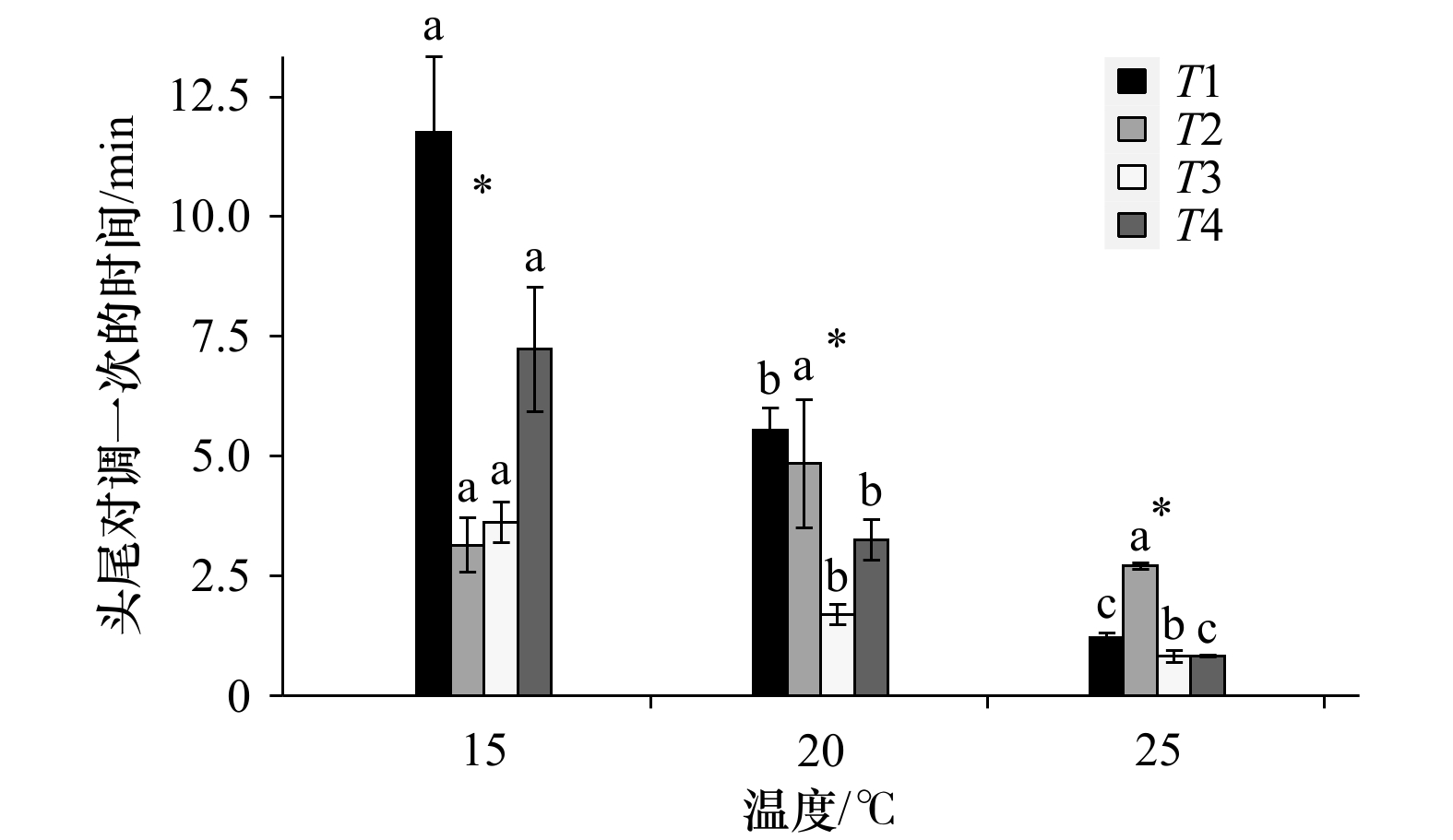
Tidal replacement has a significant impact on the physiology and behavior of intertidal organisms. Infauna can establish a suitable microenvironment to adapt to intertidal environment through the behavioral process. In this experiment, the behavioral response of Perinereis aibuhitensis Grube to tidal alternation were studied by behavioral observation device. Three temperature grades (15℃, 20℃ and 25℃) and four time periods (T1: before ebb tide, T2: after ebb tide, T3: within 30 minutes after rising tide and T4: 30 minutes after rising tide) were set up for the experiment, with six replications for each experimental group. The results showed that at the same time period, the radial undulation frequency, radial undulation pumping rate, axial crawling velocity and the frequency of head-tail exchange of P. aibuhitensis Grube tended to increase with the increase of temperature, while the time of head-tail exchange tended to decrease. At the same temperature, the radial undulation frequency, axial crawling velocity, radial undulation pumping rate, radial undulation pumping efficiency, axial crawling time and the frequency of head-tail exchange of P. aibuhitensis Grube in T3 were higher than those of other time periods, while the time of one head-tail exchange was lower. There was no significant difference in all behavioral indexes between T1 and T4 (p>0.05). At 20℃, the radial undulation frequency and pumping rate of P. aibuhitensis Grube in T3 were higher than T1. At the same time period, the radial undulation time and axial crawling time of P. aibuhitensis Grube were at the maximum and minimum at 20℃, respectively. There was no significant difference in axial crawling velocity of P. aibuhitensis Grube at 15℃ and 20℃ in T1 and T3. However, at 25℃, the axial crawling velocity in T3 was significantly higher than T1 (p<0.05). The results indicate that the motion intensity of P. aibuhitensis Grube increased with the increase of temperature. The motion state of P. aibuhitensis Grube was better at 20℃. After ebb tide, it is an important time for P. aibuhitensis Grube to forage for sediment, and its axial crawling motion is relatively slow. At the beginning of the rising tide, the motion intensity of P. aibuhitensis Grube increased significantly. 30 minutes after the rising tide, the motion of P. aibuhitensis Grube gradually returns to a state similar to that before the ebb tide. P. aibuhitensis Grube can deal with the adverse effects of tidal replacement through a series of behaviors.
Tidal replacement has a significant impact on the physiology and behavior of intertidal organisms. Infauna can establish a suitable microenvironment to adapt to intertidal environment through the behavioral process. In this experiment, the behavioral response of Perinereis aibuhitensis Grube to tidal alternation were studied by behavioral observation device. Three temperature grades (15℃, 20℃ and 25℃) and four time periods (T1: before ebb tide, T2: after ebb tide, T3: within 30 minutes after rising tide and T4: 30 minutes after rising tide) were set up for the experiment, with six replications for each experimental group. The results showed that at the same time period, the radial undulation frequency, radial undulation pumping rate, axial crawling velocity and the frequency of head-tail exchange of P. aibuhitensis Grube tended to increase with the increase of temperature, while the time of head-tail exchange tended to decrease. At the same temperature, the radial undulation frequency, axial crawling velocity, radial undulation pumping rate, radial undulation pumping efficiency, axial crawling time and the frequency of head-tail exchange of P. aibuhitensis Grube in T3 were higher than those of other time periods, while the time of one head-tail exchange was lower. There was no significant difference in all behavioral indexes between T1 and T4 (p>0.05). At 20℃, the radial undulation frequency and pumping rate of P. aibuhitensis Grube in T3 were higher than T1. At the same time period, the radial undulation time and axial crawling time of P. aibuhitensis Grube were at the maximum and minimum at 20℃, respectively. There was no significant difference in axial crawling velocity of P. aibuhitensis Grube at 15℃ and 20℃ in T1 and T3. However, at 25℃, the axial crawling velocity in T3 was significantly higher than T1 (p<0.05). The results indicate that the motion intensity of P. aibuhitensis Grube increased with the increase of temperature. The motion state of P. aibuhitensis Grube was better at 20℃. After ebb tide, it is an important time for P. aibuhitensis Grube to forage for sediment, and its axial crawling motion is relatively slow. At the beginning of the rising tide, the motion intensity of P. aibuhitensis Grube increased significantly. 30 minutes after the rising tide, the motion of P. aibuhitensis Grube gradually returns to a state similar to that before the ebb tide. P. aibuhitensis Grube can deal with the adverse effects of tidal replacement through a series of behaviors.


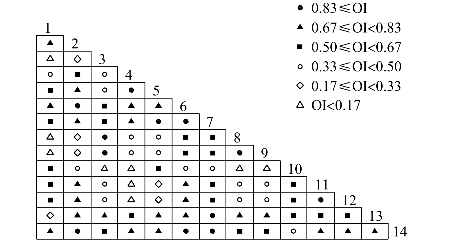
2022, 44(10): 127-139.
doi: 10.12284/hyxb2022170
Abstract:
In order to understand the relationship between zooplankton species in the Zhoushan waters and the impact of environmental factor changes on the niche differentiation of dominant species, according to the survey data of zooplankton in the Zhoushan waters in the summer of 2019 and 2020, the dominance index was used to judge the dominant species of zooplankton in this sea area. The Shannon formula and the Pianka formula were used to analyze the niche breadth and niche overlap index of the dominant zooplankton species, and the redundancy analysis (RDA) method was used to explore the main environmental factors affecting the niche differentiation of the dominant zooplankton species in the Zhoushan waters for two years. The results showed that the replacement rate of dominant zooplankton species in the Zhoushan waters was 66.67% in 2019 and 2020. According to the niche width value of the dominant species of zooplankton in the offshore Zhoushan waters, they could be divided into broad niche species, medium niche species, and narrow niche species. They accounted for 66.67% and 60.00% of the dominant species of zooplankton in 2019 and 2020, indicating that the broad niche species were the main components of the dominant species of zooplankton in the coastal waters of Zhoushan. The niche overlap index of the dominant zooplankton species ranged from 0.11 to 0.79 in 2019, and the range of the niche overlap index in 2020 was from 0 to 0.98. RDA analysis showed that the niche differentiation of zooplankton dominant species in 2019 was mainly affected by SiO3-Si concentration, COD, temperature and Chl a concentration, and the niche differentiation of zooplankton dominant species in 2020 was mainly affected by SiO3-Si concentration and DO concentration. This study is expected to further understand the interspecific relationships of zooplankton communities in the Zhoushan waters, and provide a data basis and scientific basis for studies such as elaborating the adaptation mechanism of zooplankton to environmental changes.
In order to understand the relationship between zooplankton species in the Zhoushan waters and the impact of environmental factor changes on the niche differentiation of dominant species, according to the survey data of zooplankton in the Zhoushan waters in the summer of 2019 and 2020, the dominance index was used to judge the dominant species of zooplankton in this sea area. The Shannon formula and the Pianka formula were used to analyze the niche breadth and niche overlap index of the dominant zooplankton species, and the redundancy analysis (RDA) method was used to explore the main environmental factors affecting the niche differentiation of the dominant zooplankton species in the Zhoushan waters for two years. The results showed that the replacement rate of dominant zooplankton species in the Zhoushan waters was 66.67% in 2019 and 2020. According to the niche width value of the dominant species of zooplankton in the offshore Zhoushan waters, they could be divided into broad niche species, medium niche species, and narrow niche species. They accounted for 66.67% and 60.00% of the dominant species of zooplankton in 2019 and 2020, indicating that the broad niche species were the main components of the dominant species of zooplankton in the coastal waters of Zhoushan. The niche overlap index of the dominant zooplankton species ranged from 0.11 to 0.79 in 2019, and the range of the niche overlap index in 2020 was from 0 to 0.98. RDA analysis showed that the niche differentiation of zooplankton dominant species in 2019 was mainly affected by SiO3-Si concentration, COD, temperature and Chl a concentration, and the niche differentiation of zooplankton dominant species in 2020 was mainly affected by SiO3-Si concentration and DO concentration. This study is expected to further understand the interspecific relationships of zooplankton communities in the Zhoushan waters, and provide a data basis and scientific basis for studies such as elaborating the adaptation mechanism of zooplankton to environmental changes.

2022, 44(10): 140-151.
doi: 10.12284/hyxb2022164
Abstract:
In October 2020, we sampled the benthic ciliate communities in 14 sandy intertidal zones in northern China to gain insight into the relative influence of diverse geographical scale parameters on driving the spatial pattern of microbial communities. The main findings were as follow: (1) 105 ciliates were identified belonging to 65 genera and 26 orders, and Pleuronematida, Microthoracida, and Cyclotrichida were the dominant groups; (2) although significant differences in environmental conditions were detected between the Yellow Sea and the Bohai Sea, the community composition of ciliates did not show significant difference; (3) partial Mental test revealed that environmental factors were more important than spatial distance in determining ciliate community composition, with salinity, grain size, and beach slope were the most important environmental factors in explaining ciliate spatial distribution, while tidal range and dissolved inorganic nitrogen content were less important; (4) in coastal areas, the mass effect of microorganisms somewhat hided the effects of environmental heterogeneity. In conclusion, because microorganisms in coastal environments were less restricted by dispersal, environmental variables played a larger role in the establishment of spatial distribution patterns than spatial distance. This research gives basic information on marine microbial biogeography, which can aid beach management and conservation planning in the face of global change.
In October 2020, we sampled the benthic ciliate communities in 14 sandy intertidal zones in northern China to gain insight into the relative influence of diverse geographical scale parameters on driving the spatial pattern of microbial communities. The main findings were as follow: (1) 105 ciliates were identified belonging to 65 genera and 26 orders, and Pleuronematida, Microthoracida, and Cyclotrichida were the dominant groups; (2) although significant differences in environmental conditions were detected between the Yellow Sea and the Bohai Sea, the community composition of ciliates did not show significant difference; (3) partial Mental test revealed that environmental factors were more important than spatial distance in determining ciliate community composition, with salinity, grain size, and beach slope were the most important environmental factors in explaining ciliate spatial distribution, while tidal range and dissolved inorganic nitrogen content were less important; (4) in coastal areas, the mass effect of microorganisms somewhat hided the effects of environmental heterogeneity. In conclusion, because microorganisms in coastal environments were less restricted by dispersal, environmental variables played a larger role in the establishment of spatial distribution patterns than spatial distance. This research gives basic information on marine microbial biogeography, which can aid beach management and conservation planning in the face of global change.


2022, 44(10): 152-162.
doi: 10.12284/hyxb2022158
Abstract:
Insulin-like growth factors (IGFs) are key regulators downstream of the growth axis and play an important role in promoting cell differentiation and growth. In order to further study the expression mechanism and possible roles of IGF-1 and IGF-2 genes in the embryonic development of Acanthopagrus latus. Our research cloned and identified the cDNA sequence of IGF-2 gene from A. latus and proceeded a biological information analysis. At the same time, based on the foundation of continual observation of the embryonic development of A. latus. RT-qPCR was carried out to explore the expression levels of IGF-1 and IGF-2 genes. The results suggested that the full length and open reading frame of IGF-2 gene are 1 736 bp and 648 bp respectively, encoding a predicted peptide of 215 amino acids. Multiple alignment showed that A. latus IGF-2 was 99.95% similar to Sparus aurata and 98.14% similarity with Pagrus auriga, as well as relatively high homology with other teleosts, indicating that conservation of IGF-2 in teleost evolutionary relationships. Through continuous observation of the embryonic development of A. latus, it was found that under the conditions of water temperature of (26.5±0.5)℃, pH of 8.0 and salinity of 28, the time from fertilization of egg to hatching of membrane of A. latus was 25.5 h. Expression analysis showed that IGF-1 and IGF-2 genes constitutively expresses in various tested stages of embryo of A. latus. The expression of IGF-1 gene showed a trend of first increasing and then decreasing, reaching a relatively high expression in the muscle effect period, and the expression of IGF-2 gene showed a trend of first increasing and then decreasing and then increasing, IGF-2 gene was expressed in the gastrula stage, the muscle effect stage and 3 days after membrane emergence. Summarizing, all the data of our study above showed that IGF-1 and IGF-2 genes may play a crucial role in embryonic development in A. latus.
Insulin-like growth factors (IGFs) are key regulators downstream of the growth axis and play an important role in promoting cell differentiation and growth. In order to further study the expression mechanism and possible roles of IGF-1 and IGF-2 genes in the embryonic development of Acanthopagrus latus. Our research cloned and identified the cDNA sequence of IGF-2 gene from A. latus and proceeded a biological information analysis. At the same time, based on the foundation of continual observation of the embryonic development of A. latus. RT-qPCR was carried out to explore the expression levels of IGF-1 and IGF-2 genes. The results suggested that the full length and open reading frame of IGF-2 gene are 1 736 bp and 648 bp respectively, encoding a predicted peptide of 215 amino acids. Multiple alignment showed that A. latus IGF-2 was 99.95% similar to Sparus aurata and 98.14% similarity with Pagrus auriga, as well as relatively high homology with other teleosts, indicating that conservation of IGF-2 in teleost evolutionary relationships. Through continuous observation of the embryonic development of A. latus, it was found that under the conditions of water temperature of (26.5±0.5)℃, pH of 8.0 and salinity of 28, the time from fertilization of egg to hatching of membrane of A. latus was 25.5 h. Expression analysis showed that IGF-1 and IGF-2 genes constitutively expresses in various tested stages of embryo of A. latus. The expression of IGF-1 gene showed a trend of first increasing and then decreasing, reaching a relatively high expression in the muscle effect period, and the expression of IGF-2 gene showed a trend of first increasing and then decreasing and then increasing, IGF-2 gene was expressed in the gastrula stage, the muscle effect stage and 3 days after membrane emergence. Summarizing, all the data of our study above showed that IGF-1 and IGF-2 genes may play a crucial role in embryonic development in A. latus.


2022, 44(10): 163-172.
doi: 10.12284/hyxb2022182
Abstract:
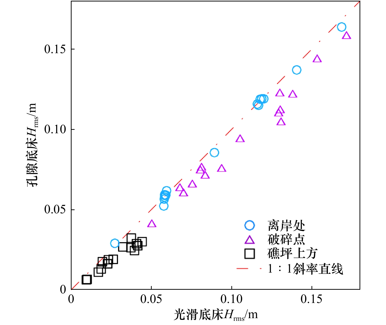
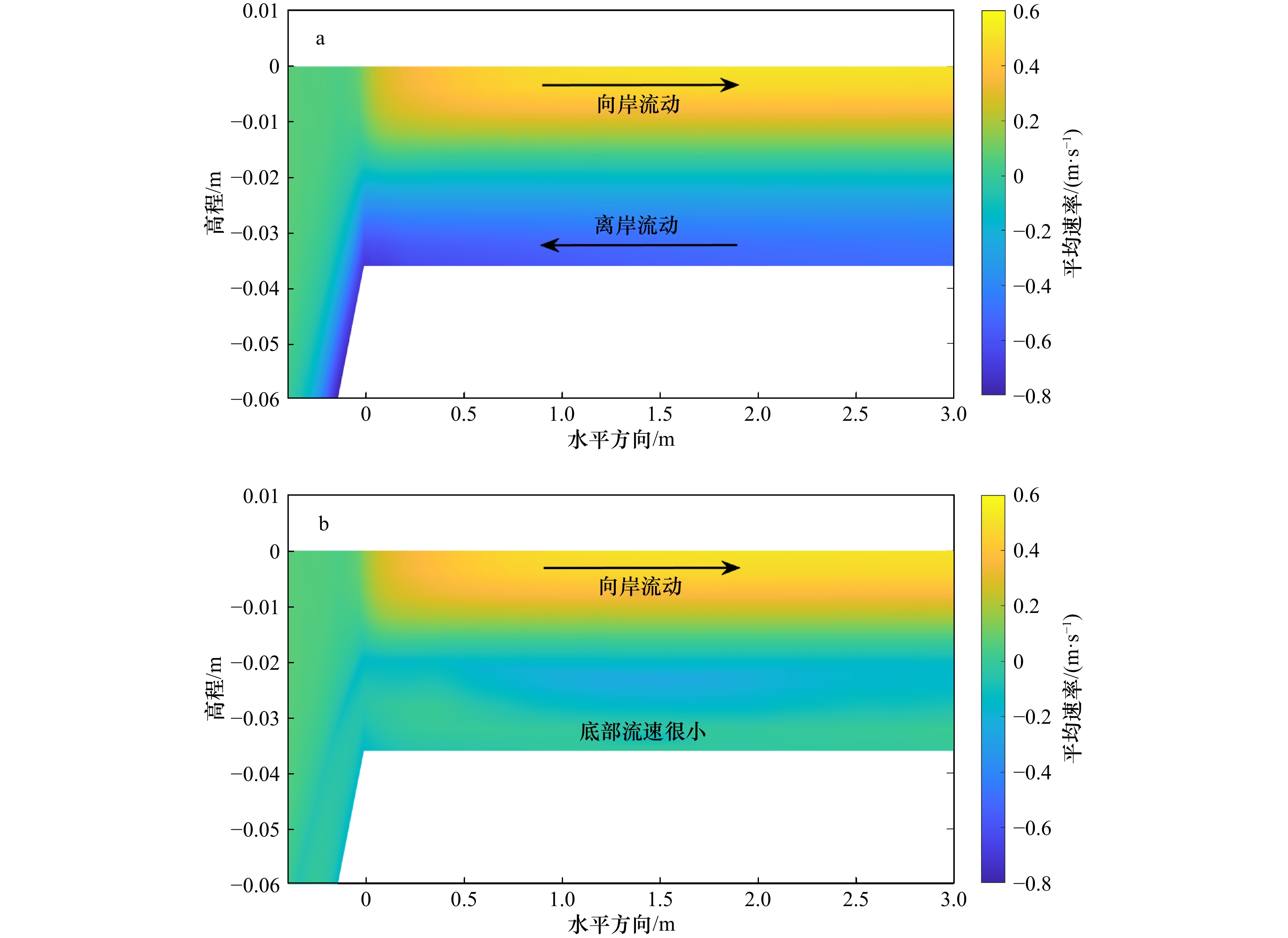
A three-dimensional non-hydrostatic model based on volumed-averaged, Reynolds-averaged Navier-Stokes (VARANS) equations in sigma coordinate, is applied to simulate the propagation process of irregular wave over a typical fringing coral reef profile, with emphasis on the changes of wave height and wave setup on the reef flat. Compared with the laboratory measured data of several groups of wave and water level parameters, the model is shown to be capable of simulating well the wave transformation over the reef profile with and without porous media. Across all cases, the porous cases decrease the wave height by 12% around the breaking point, and by 28% on the reef flat than the smooth cases. As for the mean water level, the results show that the maximum setdown decreases by 43% on average for the porous cases than the smooth cases, while the wave setup on the reef flat for corresponding porous and smooth simulations is found to agree with an average difference of only 6%. In addition, the variation of porosity in the range 0.47−0.87 auses little effect on the wave setup.
A three-dimensional non-hydrostatic model based on volumed-averaged, Reynolds-averaged Navier-Stokes (VARANS) equations in sigma coordinate, is applied to simulate the propagation process of irregular wave over a typical fringing coral reef profile, with emphasis on the changes of wave height and wave setup on the reef flat. Compared with the laboratory measured data of several groups of wave and water level parameters, the model is shown to be capable of simulating well the wave transformation over the reef profile with and without porous media. Across all cases, the porous cases decrease the wave height by 12% around the breaking point, and by 28% on the reef flat than the smooth cases. As for the mean water level, the results show that the maximum setdown decreases by 43% on average for the porous cases than the smooth cases, while the wave setup on the reef flat for corresponding porous and smooth simulations is found to agree with an average difference of only 6%. In addition, the variation of porosity in the range 0.47−0.87 auses little effect on the wave setup.


2022, 44(10): 173-181.
doi: 10.12284/hyxb2022168
Abstract:
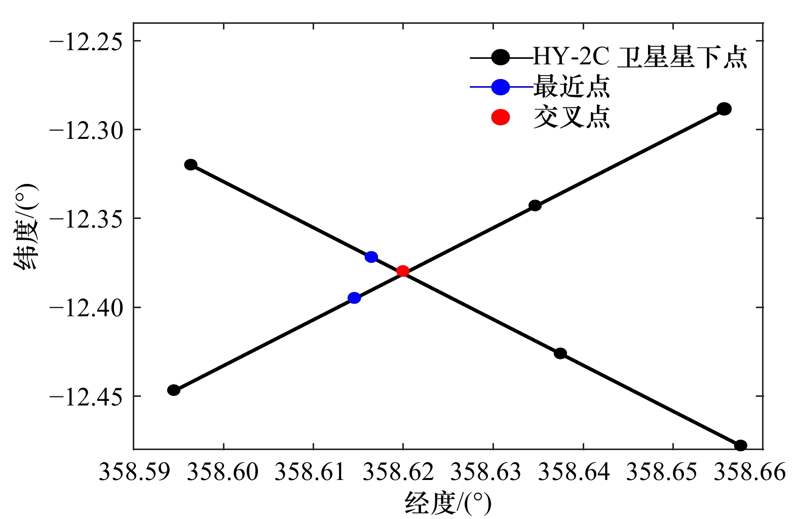
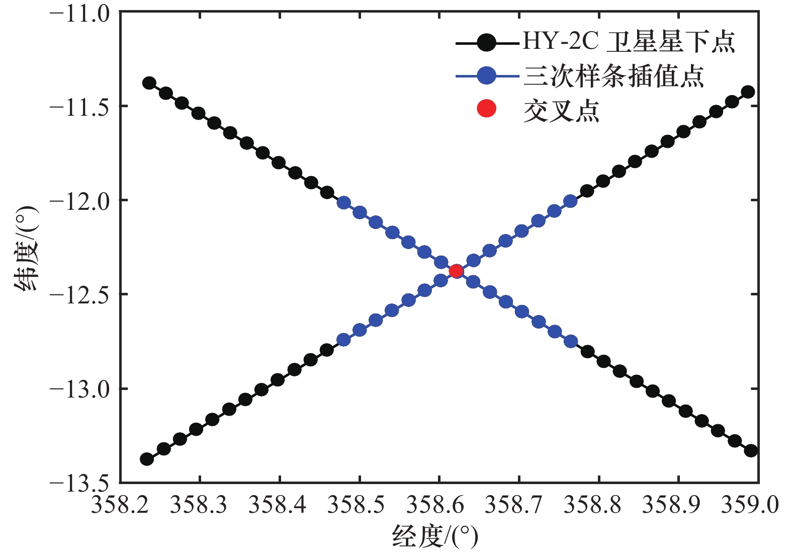
As an important part of monitoring oceanic phenomenon, it is essential to calibrate altimeter sea level height data. In 2020, the Haiyang-2C (HY-2C) satellite was sent to orbit as a follow-up mission of the HY-2B satellite. However, the quality of HY-2C sea level height is not fully known yet. In this paper, the quality and accuracy of HY-2C sensor geophysical data records (SGDR) of the latest version were assessed through the comparison with the HY-2B geophysical data records (GDR) and Jason-3 GDR measured at the same time. According to the results: self-crossover points analysis is carried out by star cross calibration of HY-2C satellite. The quality analysis results of sea level anomaly data of HY-2C SGDR are different. Through the comparison results, the optimal cubic spline interpolation method has the best quality analysis performance, with mean value is 0.03 cm and the standard deviation is 6.17 cm. The mean and standard deviation of sea level anomaly at the dual-crossing calibration of HY-2C and HY-2B satellites are −0.47 cm and 5.32 cm. The mean and standard deviation of sea level anomaly at the intersection of HY-2C and Jason-3 satellites are −0.3 cm and 5.32 cm. These results show that HY-2C has the same precision as HY-2B satellite and Jason-3 satellite. Data quality of HY-2C satellite is enough to meet the requirements of marine scientific research and application.
As an important part of monitoring oceanic phenomenon, it is essential to calibrate altimeter sea level height data. In 2020, the Haiyang-2C (HY-2C) satellite was sent to orbit as a follow-up mission of the HY-2B satellite. However, the quality of HY-2C sea level height is not fully known yet. In this paper, the quality and accuracy of HY-2C sensor geophysical data records (SGDR) of the latest version were assessed through the comparison with the HY-2B geophysical data records (GDR) and Jason-3 GDR measured at the same time. According to the results: self-crossover points analysis is carried out by star cross calibration of HY-2C satellite. The quality analysis results of sea level anomaly data of HY-2C SGDR are different. Through the comparison results, the optimal cubic spline interpolation method has the best quality analysis performance, with mean value is 0.03 cm and the standard deviation is 6.17 cm. The mean and standard deviation of sea level anomaly at the dual-crossing calibration of HY-2C and HY-2B satellites are −0.47 cm and 5.32 cm. The mean and standard deviation of sea level anomaly at the intersection of HY-2C and Jason-3 satellites are −0.3 cm and 5.32 cm. These results show that HY-2C has the same precision as HY-2B satellite and Jason-3 satellite. Data quality of HY-2C satellite is enough to meet the requirements of marine scientific research and application.


 Email alert
 RSS
RSS