


2021 Vol. 43, No. 3
Display Method:
2021, 43(3): 1-12.
doi: 10.12284/hyxb2021029
Abstract:
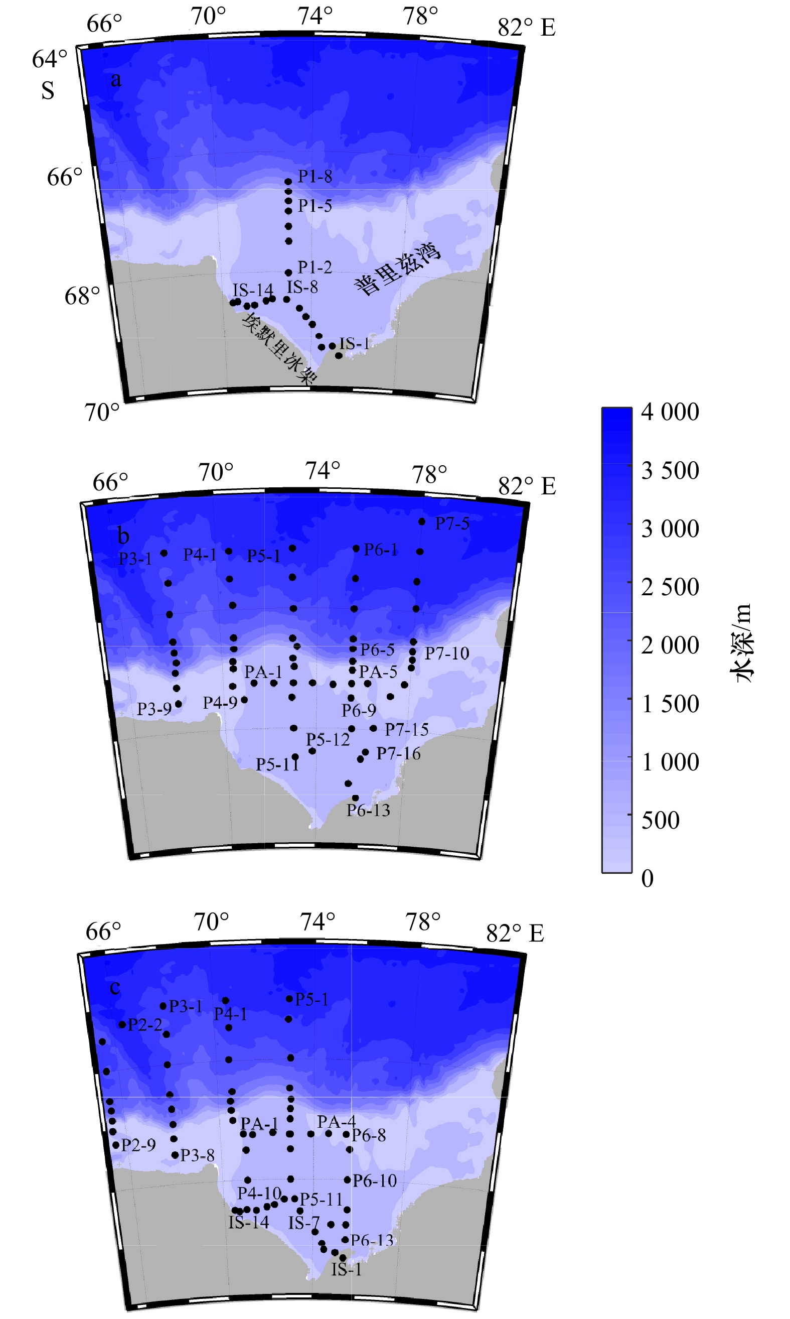
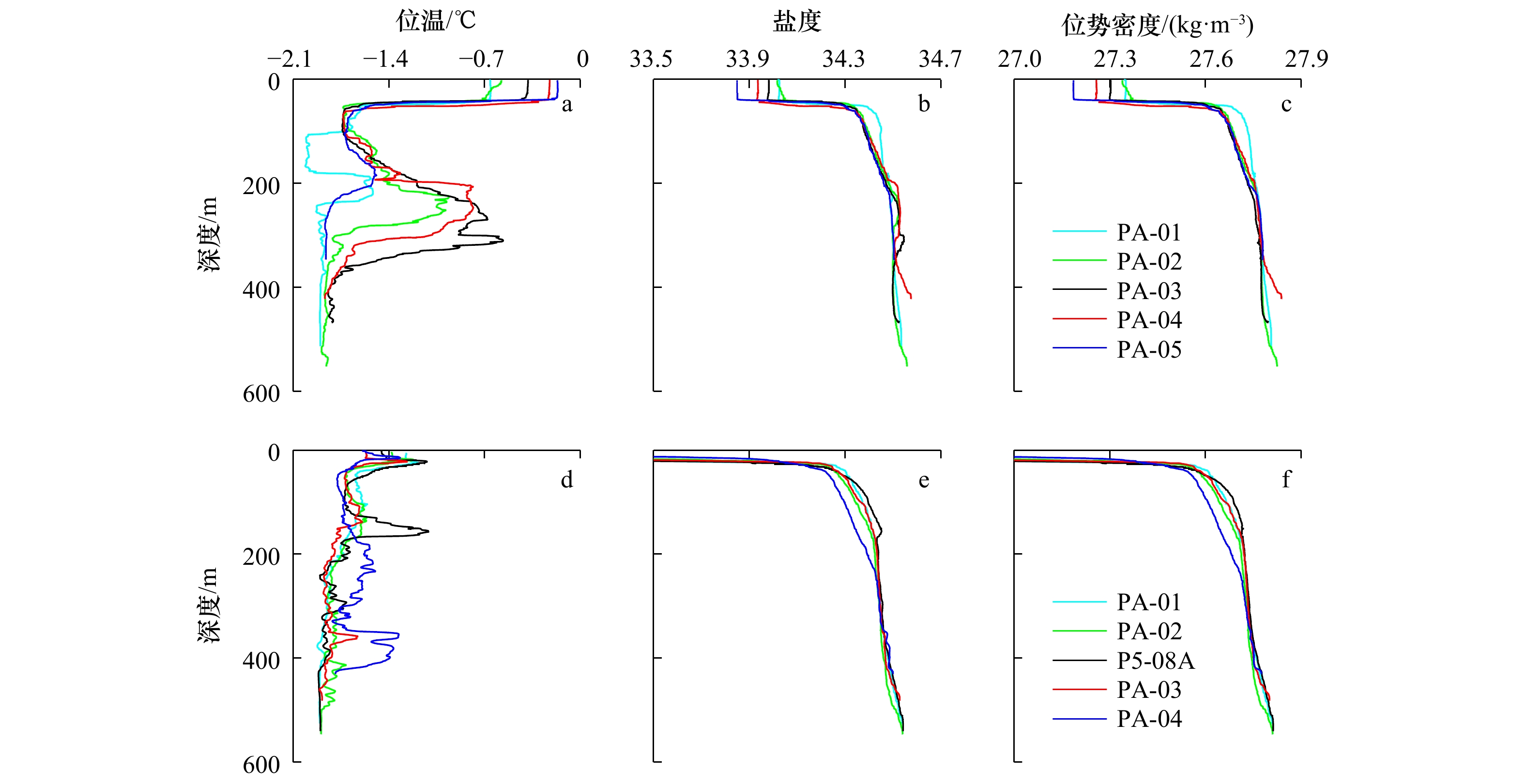
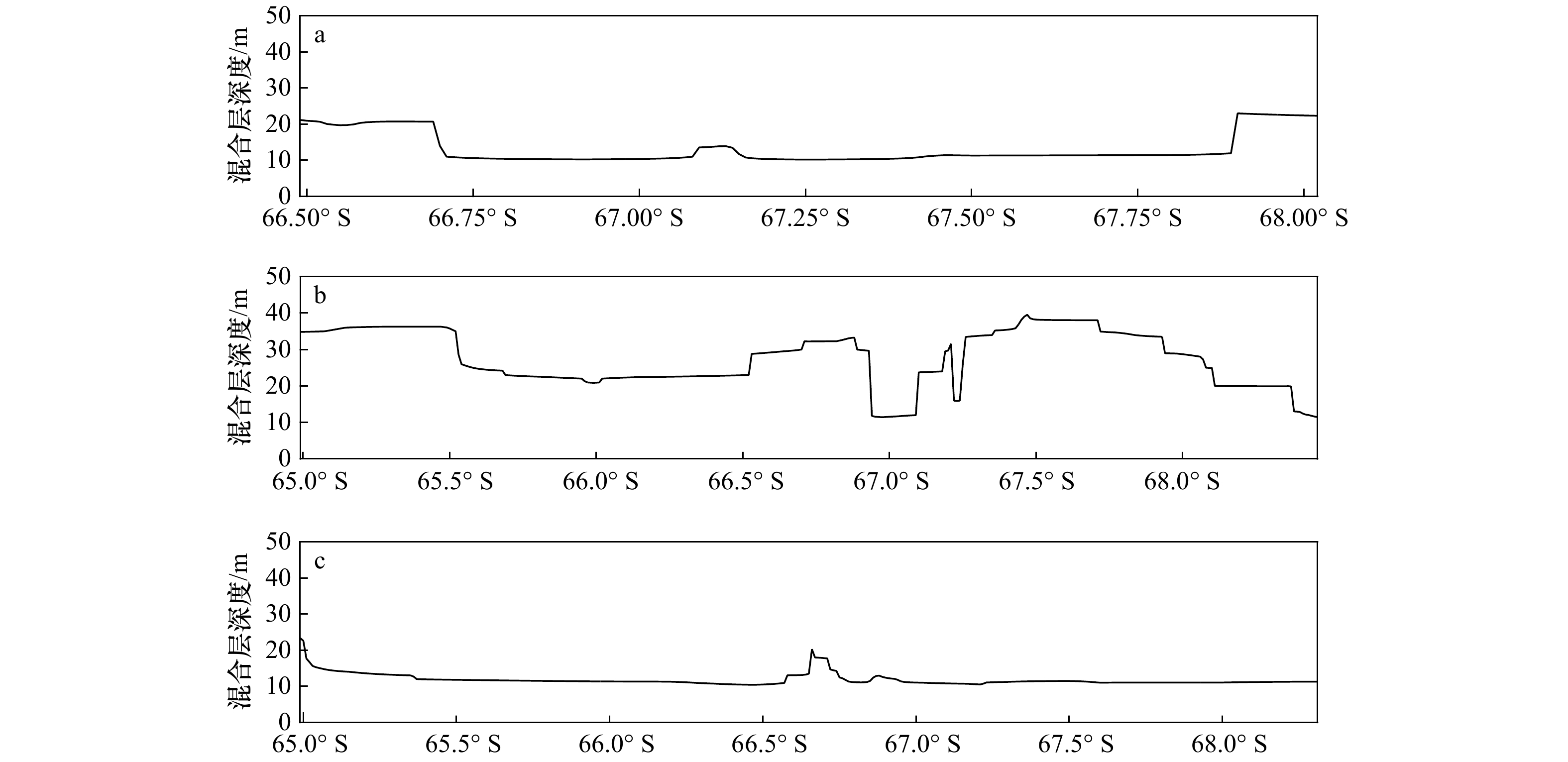
Based on the CTD data from the 28th, 29th and 31st Chinese Antarctic Expedition cruises, we calculated dissipation rate of turbulent kinetic energy by using Thrope scale method, and analyzed the distribution characteristics of the dissipation rate and the structure of water masses in the Prydz Bay and its adjacent waters. Results show that the subsurface dissipation rate intensity of turbulent kinetic energy in the first two cruises reach maximum on the shelf break of Prydz Bay. Moreover, we compared the distribution of water masses among the three cruises and found intrusion of the modified circumplar deep water into the shelf happened on the 28th and 29th cruises. The the modified circumplar deep water could reach the depth of 100 m and 200 m on the cruise of 28th and 29th, respectively, and can extend southward to 67.5°S. Furthermore, the distribution of subsurface dissipation rate of turbulent kinetic energy on the shelf break of Prydz Bay are well related to the structure of local water masses. Therefore, the intrusion of the modified circumplar deep water into the shelf could induce instability of the local waters, promote water exchange and finally enhance local turbulent mixing.
Based on the CTD data from the 28th, 29th and 31st Chinese Antarctic Expedition cruises, we calculated dissipation rate of turbulent kinetic energy by using Thrope scale method, and analyzed the distribution characteristics of the dissipation rate and the structure of water masses in the Prydz Bay and its adjacent waters. Results show that the subsurface dissipation rate intensity of turbulent kinetic energy in the first two cruises reach maximum on the shelf break of Prydz Bay. Moreover, we compared the distribution of water masses among the three cruises and found intrusion of the modified circumplar deep water into the shelf happened on the 28th and 29th cruises. The the modified circumplar deep water could reach the depth of 100 m and 200 m on the cruise of 28th and 29th, respectively, and can extend southward to 67.5°S. Furthermore, the distribution of subsurface dissipation rate of turbulent kinetic energy on the shelf break of Prydz Bay are well related to the structure of local water masses. Therefore, the intrusion of the modified circumplar deep water into the shelf could induce instability of the local waters, promote water exchange and finally enhance local turbulent mixing.


2021, 43(3): 13-23.
doi: 10.12284/hyxb2021097
Abstract:
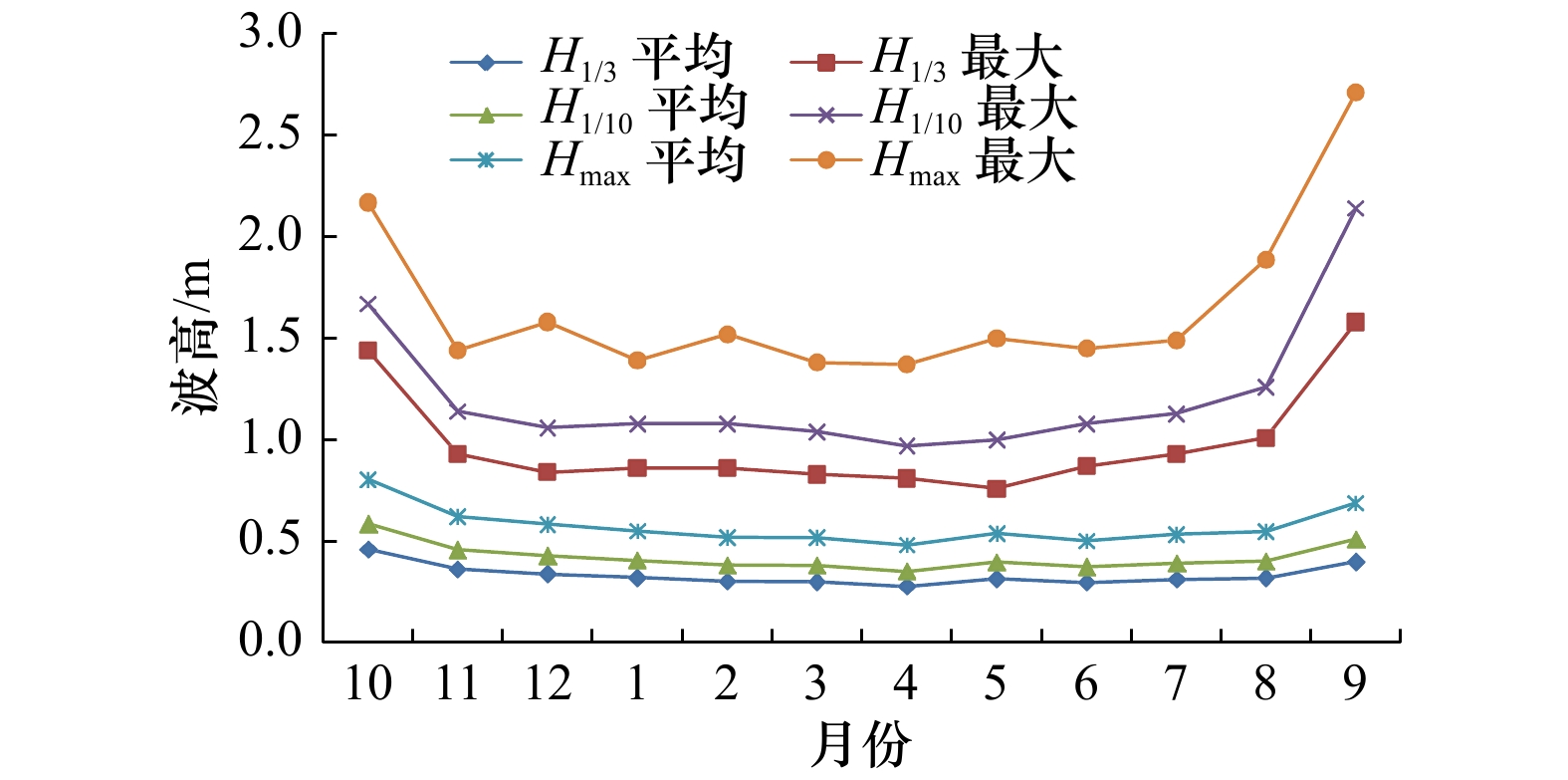
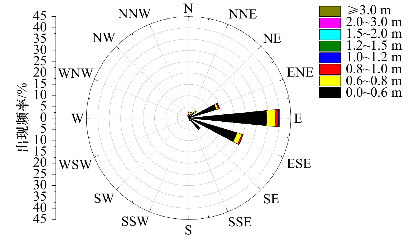
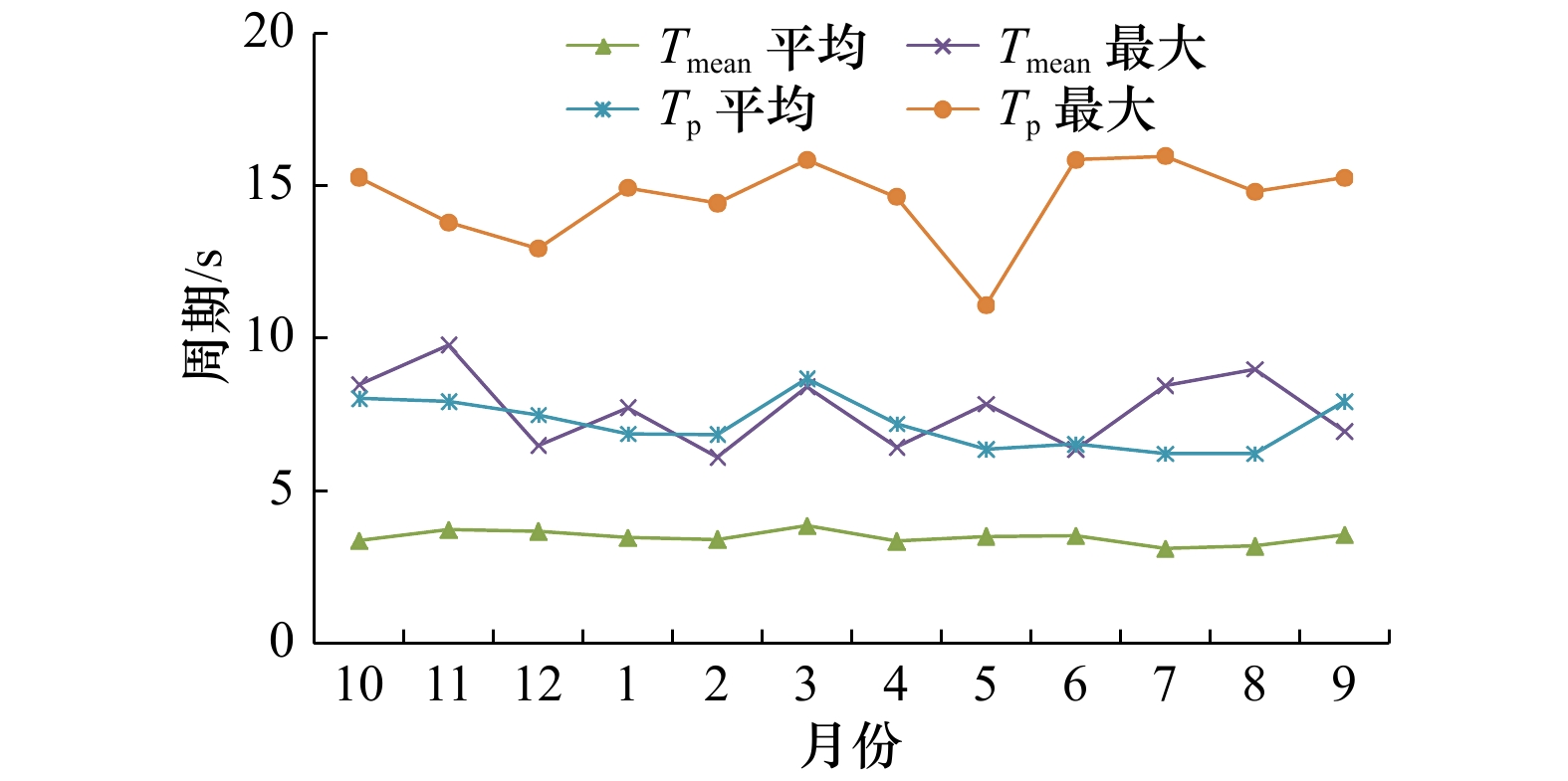
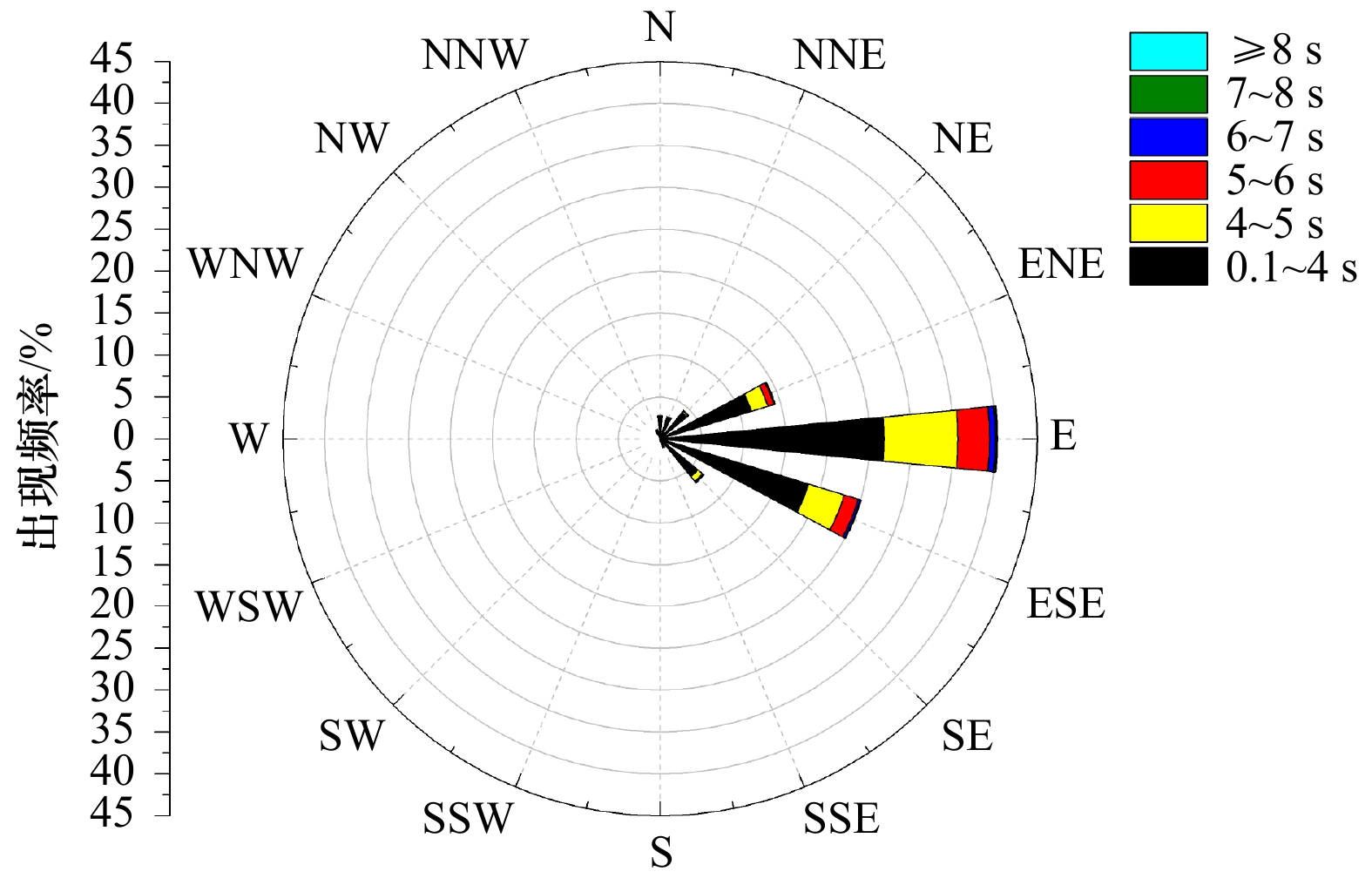
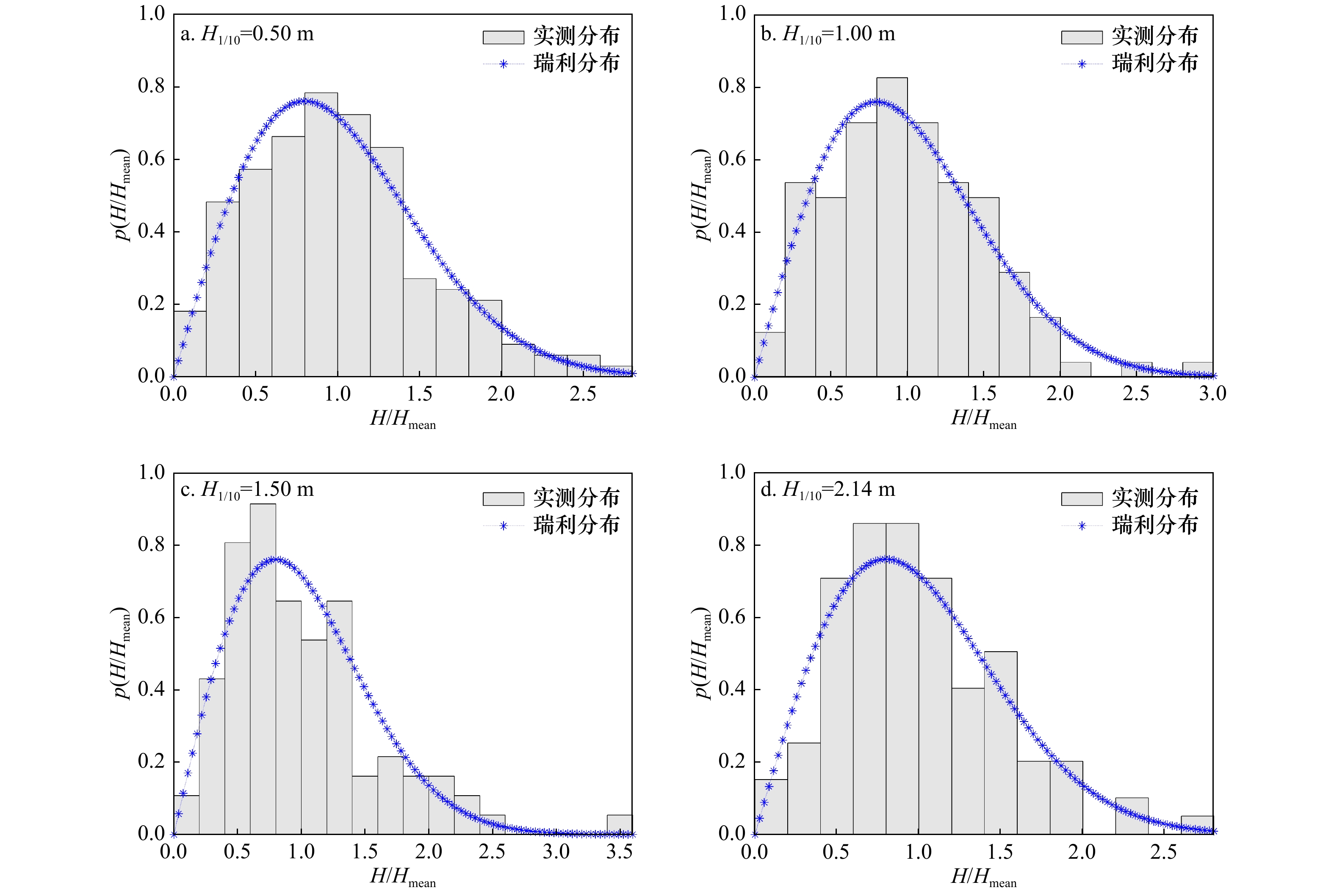
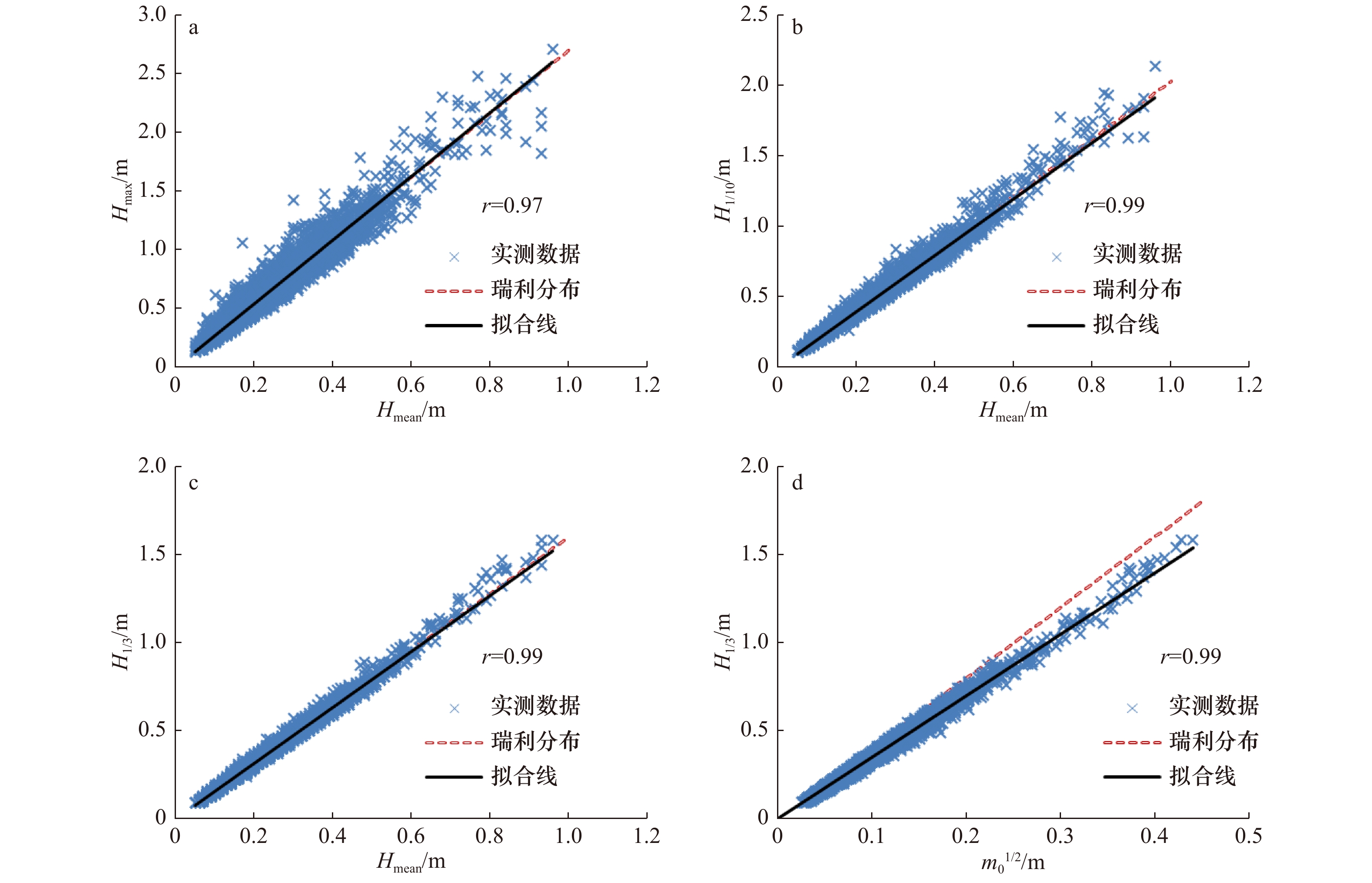
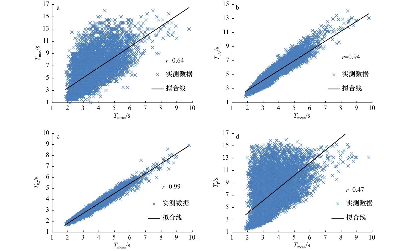
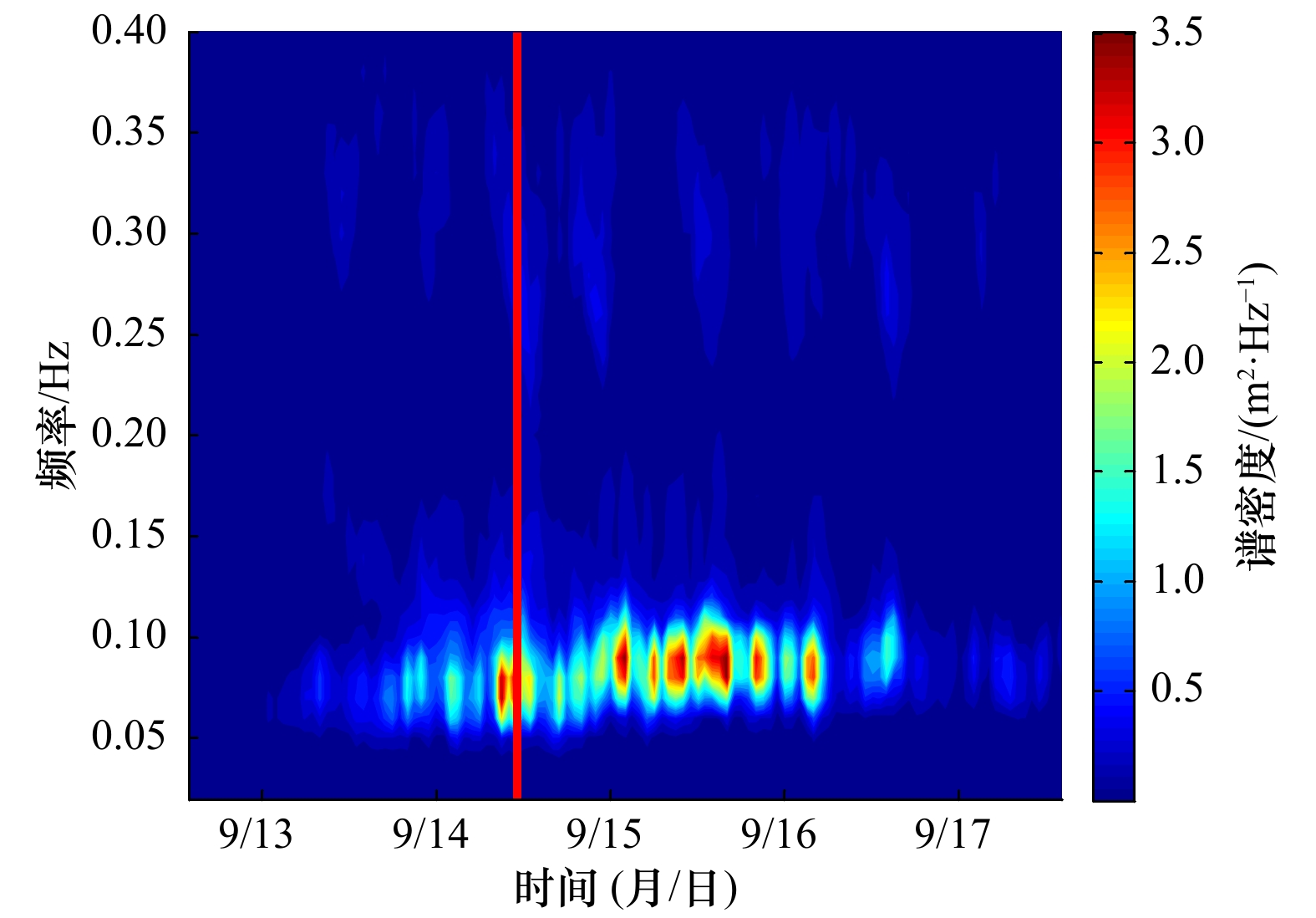
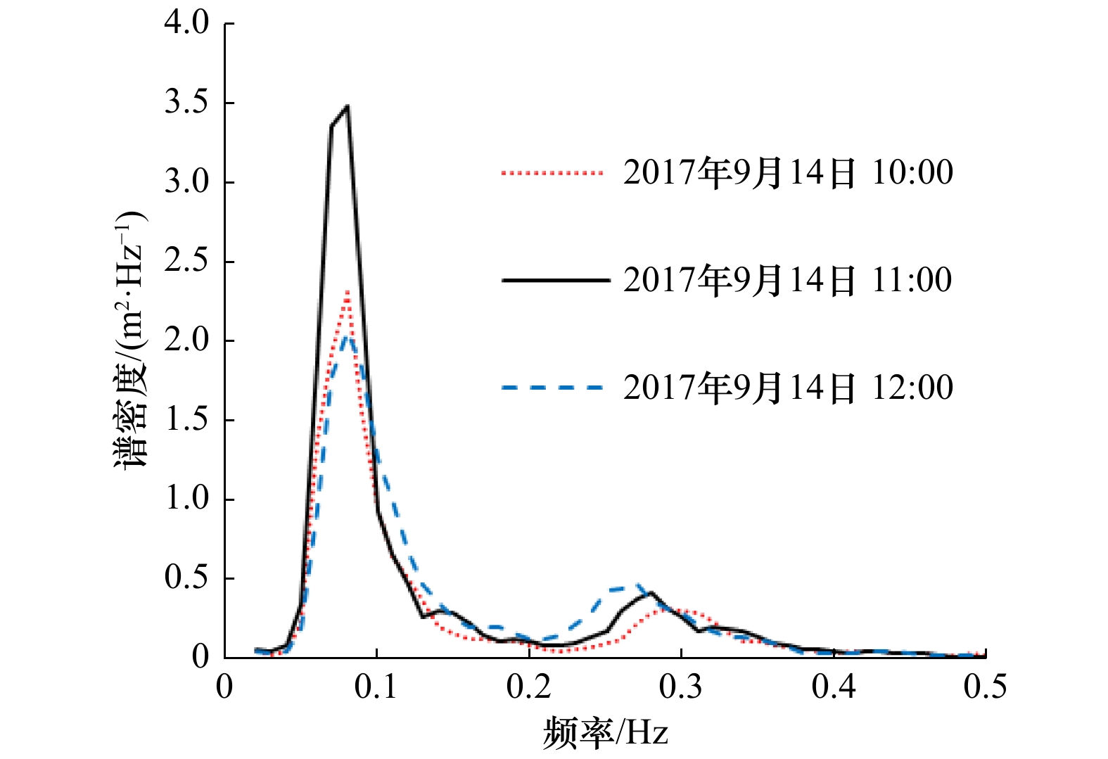
In order to study the wave characteristics in the Sanmen Bay, field observation based on AWAC data acquisition equipment was continued for one year, and the statistical analysis, linear regression analysis was done. Moreover, statistics and spectral variations of waves during the typhoon occurrence were investigated, and the reason for the variations was determined on the basis of wave data collected. The results show that the dominant wave direction and the strong wave direction are both E due to the topography of coastal areas; during the wave observation period, H1/10 is mainly under 0.8 m, and Hmax is 2.71 m; the distribution of wave characteristics is a typical Rayleigh distribution in this region; the wave spectra estimated during Typhoon Talim is double-peaked, and the total wave is a combination of swell and wind sea, when the low frequency swell about 0.08 Hz is in a dominant position and the high frequency wind sea about 0.25 Hz is relatively weak. This study will be important as reference in the design of offshore structures as well as for disaster prevention and mitigation.
In order to study the wave characteristics in the Sanmen Bay, field observation based on AWAC data acquisition equipment was continued for one year, and the statistical analysis, linear regression analysis was done. Moreover, statistics and spectral variations of waves during the typhoon occurrence were investigated, and the reason for the variations was determined on the basis of wave data collected. The results show that the dominant wave direction and the strong wave direction are both E due to the topography of coastal areas; during the wave observation period, H1/10 is mainly under 0.8 m, and Hmax is 2.71 m; the distribution of wave characteristics is a typical Rayleigh distribution in this region; the wave spectra estimated during Typhoon Talim is double-peaked, and the total wave is a combination of swell and wind sea, when the low frequency swell about 0.08 Hz is in a dominant position and the high frequency wind sea about 0.25 Hz is relatively weak. This study will be important as reference in the design of offshore structures as well as for disaster prevention and mitigation.


2021, 43(3): 24-30.
doi: 10.12284/hyxb2021053
Abstract:
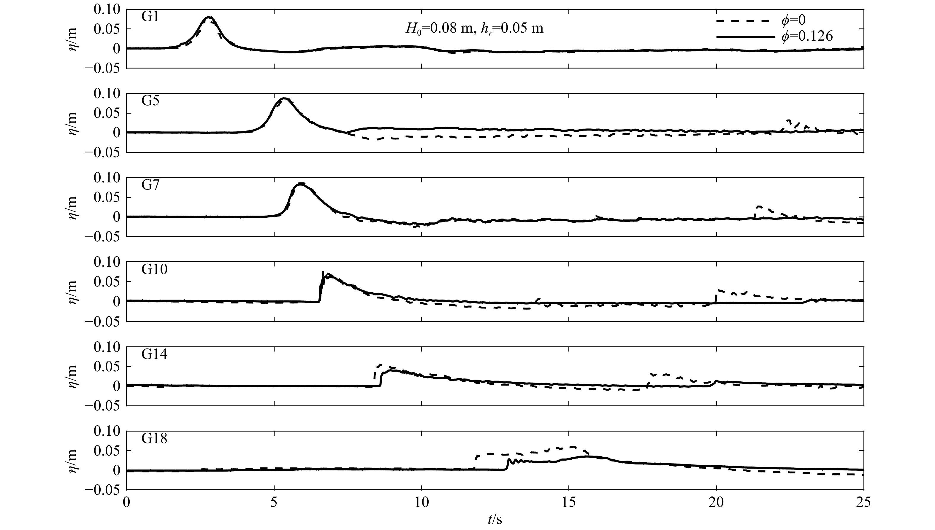
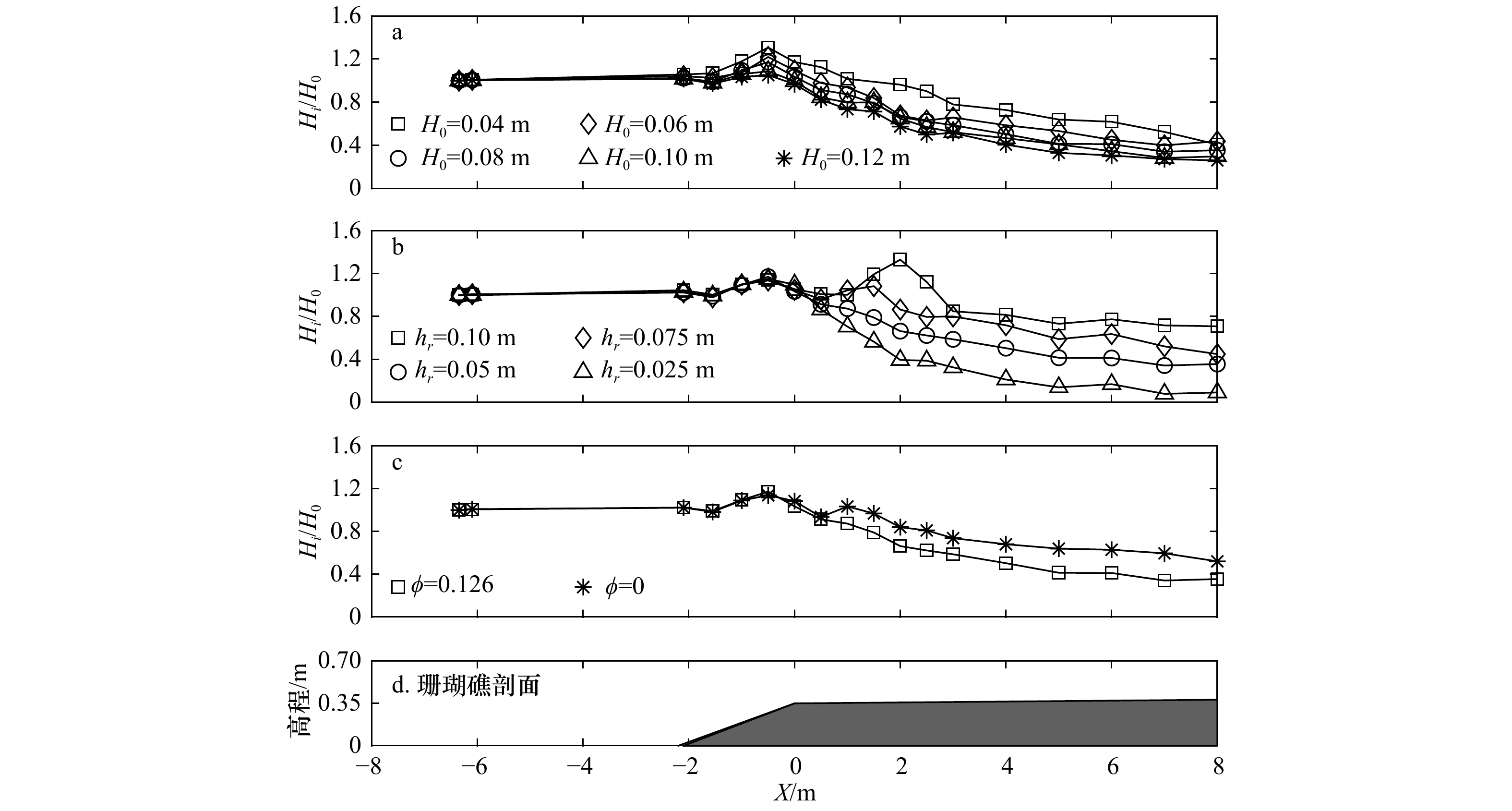
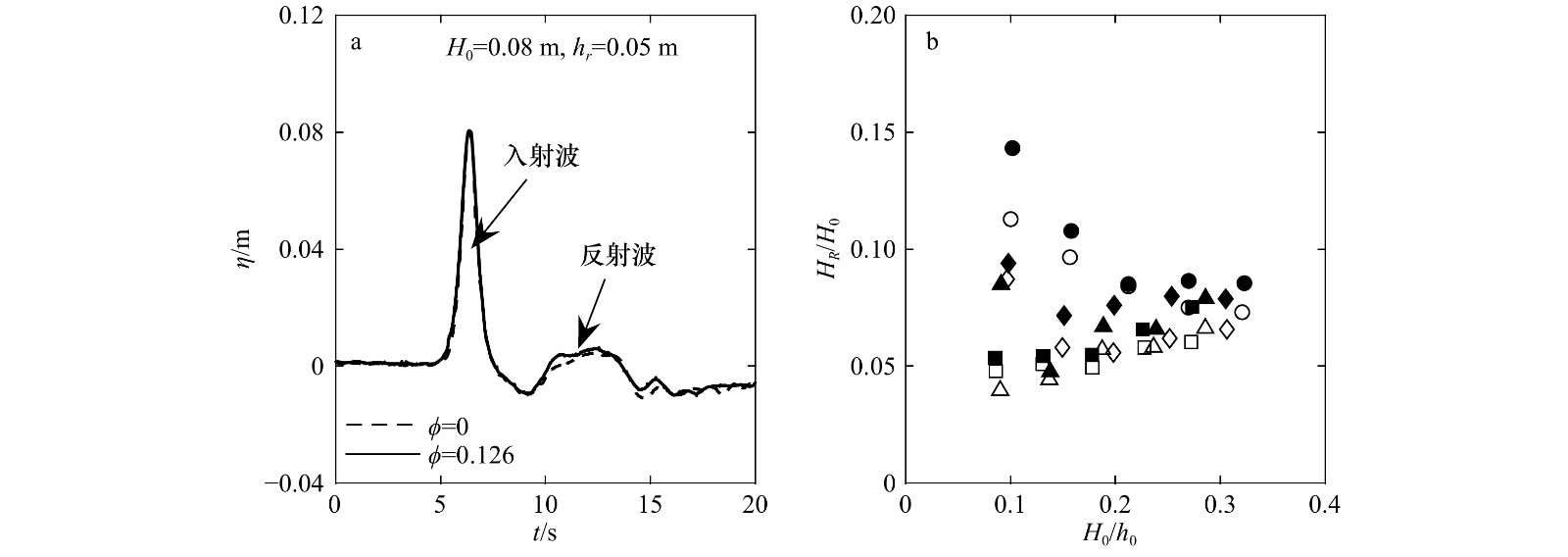
A series of laboratory experiments is carried out in a wave flume to study the influence of rough reef surface on solitary wave transformation and run-up over coral reefs. The cylinder array is used to model the reef surface with large roughness. The results show that the rough reef surface significantly reduces the leading solitary wave and the secondary wave due to beach-reef beach reflection, as well as the wave speed on the reef flat. The relative cross-shore wave height decreases with the increase of dimensionless incident wave height along the reef. It also increases with the increase of reef-flat wave level. The cross-shore wave height attenuation is more evident with the rough reef surface. The variation of dimensionless reflected wave height with the dimensionless incident wave height depends on the reef-flat wave level. The dimensionless reflected wave height approaches to a constant when the incident wave height is sufficient large. The rough reef surface slightly enhances the wave reflection from the fore-reef slope. The dimensionless transmitted wave height as well as wave run-up decline with the increasing dimensionless incident wave height, particularly for the large reef-flat water level. The dimensionless wave run-up on the back-reef beach with the rough reef surface reduces by an average of 46% compared to that with the smooth surface. An empirical formula is obtained by a regression analysis to predict the wave run-up with both smooth and rough reefs.
A series of laboratory experiments is carried out in a wave flume to study the influence of rough reef surface on solitary wave transformation and run-up over coral reefs. The cylinder array is used to model the reef surface with large roughness. The results show that the rough reef surface significantly reduces the leading solitary wave and the secondary wave due to beach-reef beach reflection, as well as the wave speed on the reef flat. The relative cross-shore wave height decreases with the increase of dimensionless incident wave height along the reef. It also increases with the increase of reef-flat wave level. The cross-shore wave height attenuation is more evident with the rough reef surface. The variation of dimensionless reflected wave height with the dimensionless incident wave height depends on the reef-flat wave level. The dimensionless reflected wave height approaches to a constant when the incident wave height is sufficient large. The rough reef surface slightly enhances the wave reflection from the fore-reef slope. The dimensionless transmitted wave height as well as wave run-up decline with the increasing dimensionless incident wave height, particularly for the large reef-flat water level. The dimensionless wave run-up on the back-reef beach with the rough reef surface reduces by an average of 46% compared to that with the smooth surface. An empirical formula is obtained by a regression analysis to predict the wave run-up with both smooth and rough reefs.


2021, 43(3): 31-39.
doi: 10.12284/hyxb2021047
Abstract:
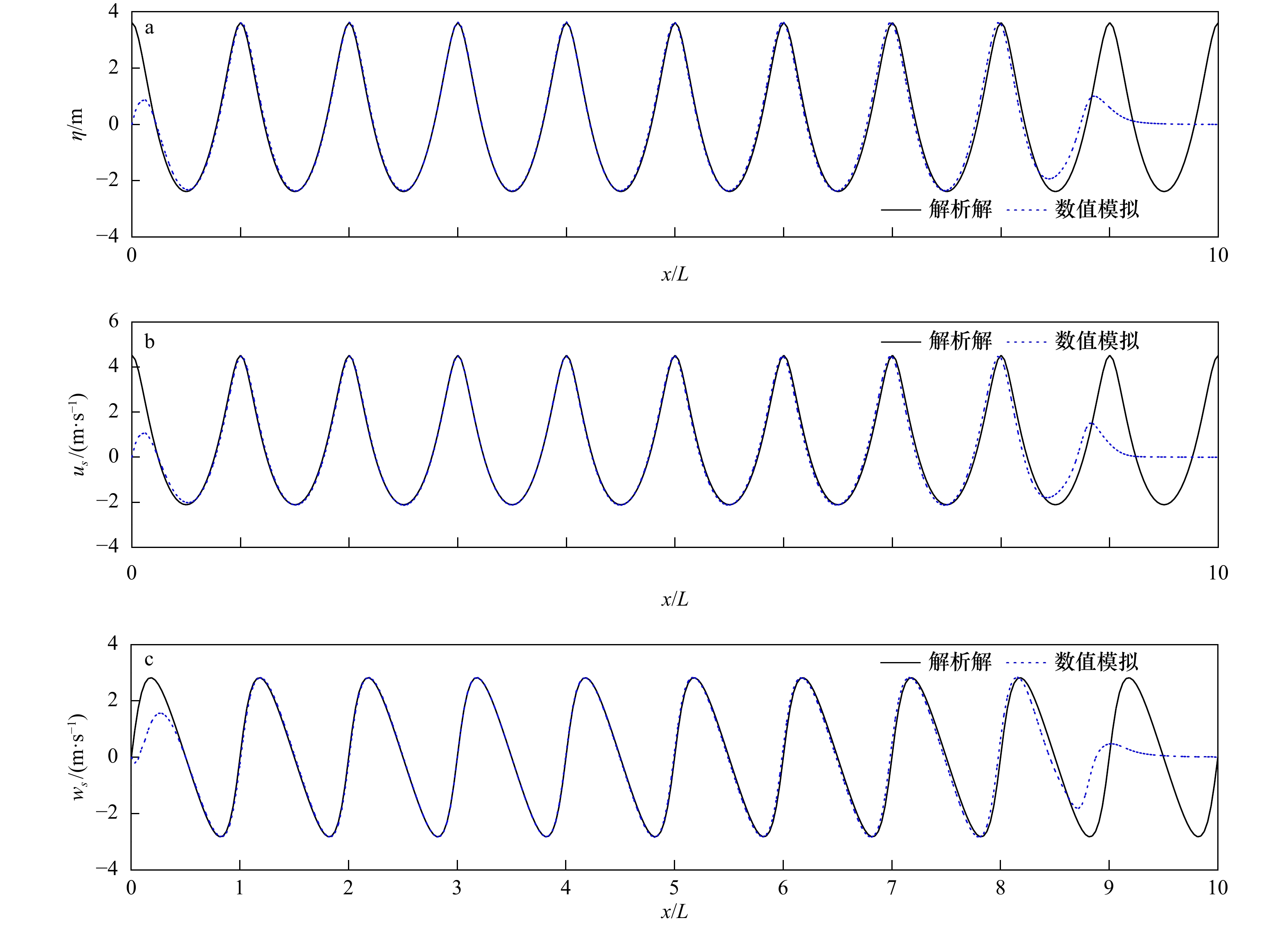
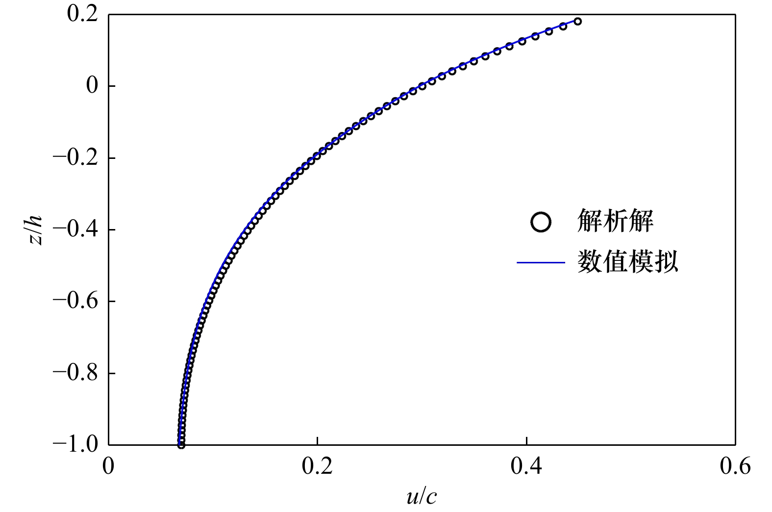
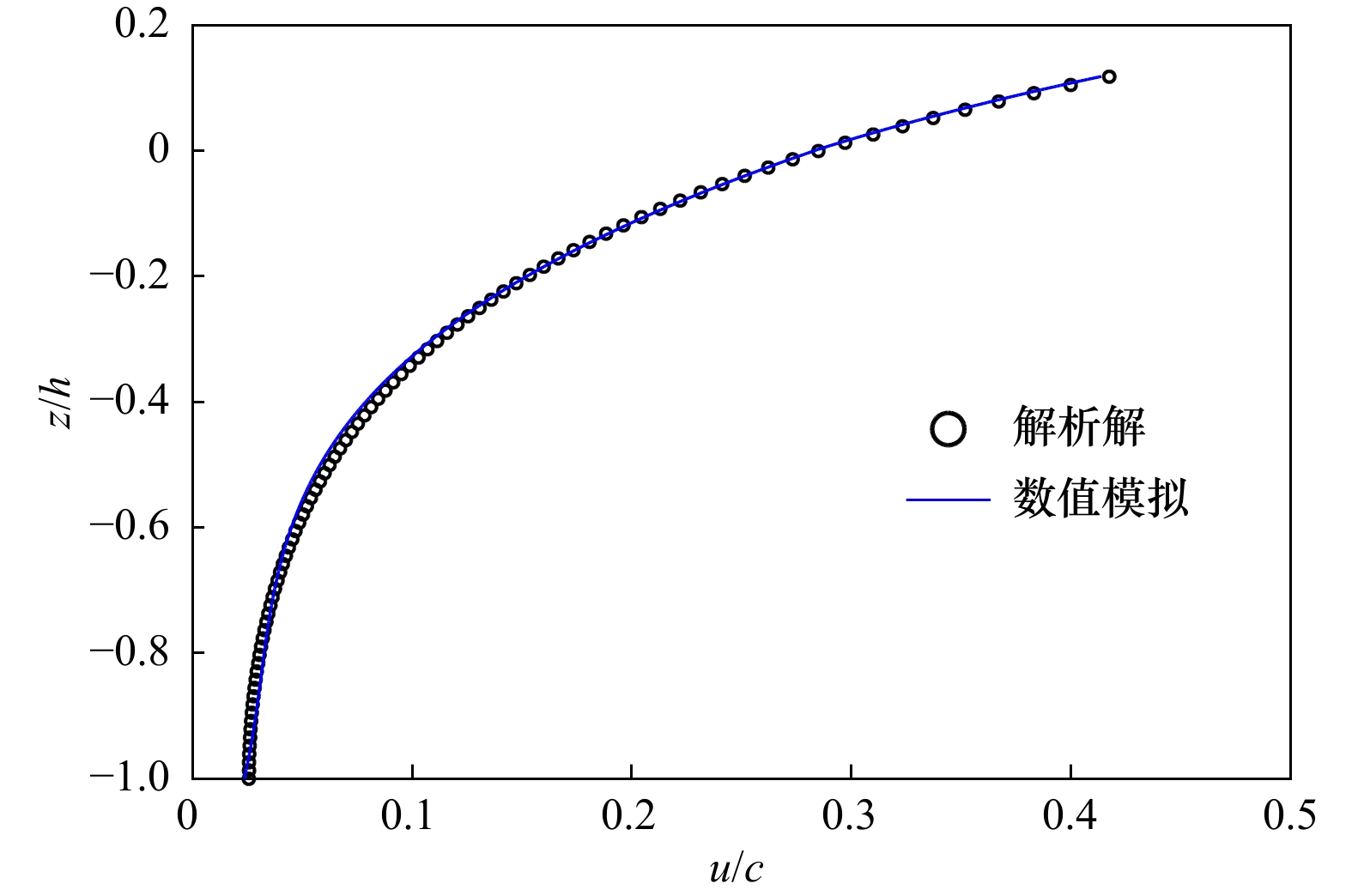
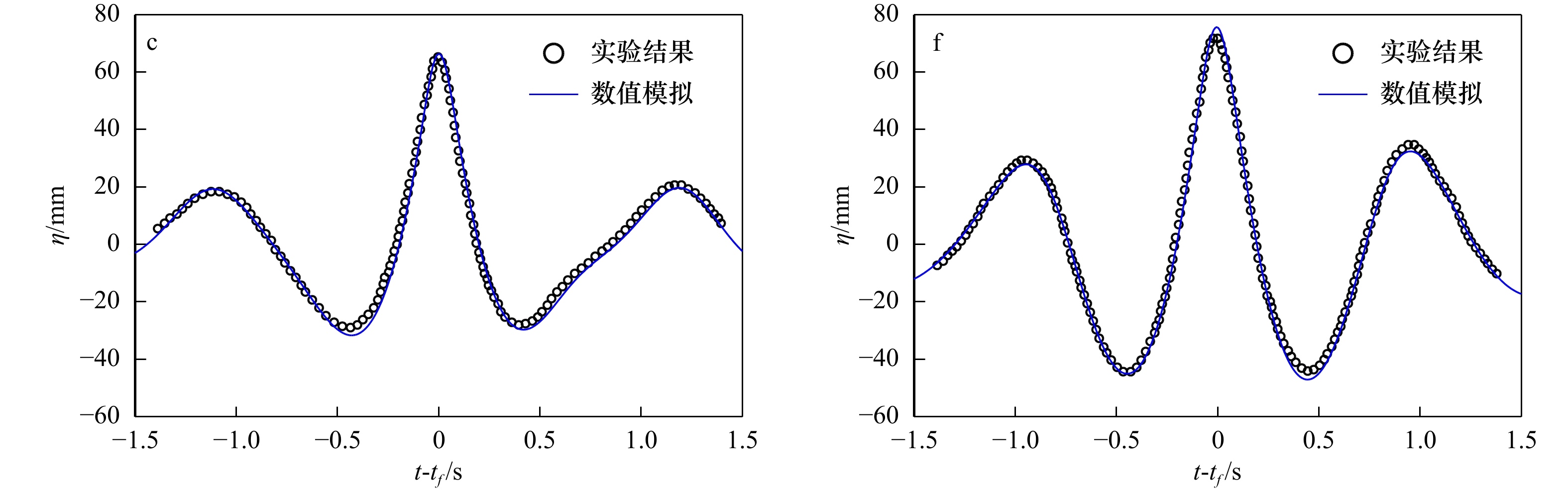
Based on the one-layer Boussinesq model with highest spatial derivative being 3, a numerical model is established for focused wave group. The numerical model is solved with predictor-corrector scheme in finite differential method. For time integration, a third-order Adams-Bashforth scheme and a fourth-order Adams-Moulton scheme are separately used in predicting stage and correcting stage. Firstly, the numerical simulations are carried out upon nonlinear regular wave evolution over a constant water-depth in a flume, and the computed results are compared with the semi-analytical solutions. The results demonstrate that the simulated surface elevations, the horizontal velocity and vertical velocity on the free surface can well match the related analytical solutions, while the agreement of the horizontal velocity profile under the crest becomes worse with the increase of water-depth, and the range of the model with respect to nonlinear horizontal velocity profile is for kh<3.5, which is similar to the range of the related linear model with respect to horizontal velocity profile. Secondly, the numerical simulations are conducted upon the nonlinear focused wave group evolution in deep-water. The linear wave groups are used as incident wave conditions. The laboratory experiments conducted by Baldock and Swan (1996) are used to examine the present model. Both the computed surface elevations and the horizontal velocity profile at the focused position are compared with the related experimental data. The results show that the agreement of the surface elevations is pretty good, while the agreement of the horizontal velocity profile is moderate. Finally, with the middle frequency being kept unchanged, the numerical simulations upon the maximum surface elevation and horizontal velocity under the crest are conducted with the variation of the range of focused wave period, the results show that both the crest and the horizontal velocity increase with the increase of the range of the wave periods.
Based on the one-layer Boussinesq model with highest spatial derivative being 3, a numerical model is established for focused wave group. The numerical model is solved with predictor-corrector scheme in finite differential method. For time integration, a third-order Adams-Bashforth scheme and a fourth-order Adams-Moulton scheme are separately used in predicting stage and correcting stage. Firstly, the numerical simulations are carried out upon nonlinear regular wave evolution over a constant water-depth in a flume, and the computed results are compared with the semi-analytical solutions. The results demonstrate that the simulated surface elevations, the horizontal velocity and vertical velocity on the free surface can well match the related analytical solutions, while the agreement of the horizontal velocity profile under the crest becomes worse with the increase of water-depth, and the range of the model with respect to nonlinear horizontal velocity profile is for kh<3.5, which is similar to the range of the related linear model with respect to horizontal velocity profile. Secondly, the numerical simulations are conducted upon the nonlinear focused wave group evolution in deep-water. The linear wave groups are used as incident wave conditions. The laboratory experiments conducted by Baldock and Swan (1996) are used to examine the present model. Both the computed surface elevations and the horizontal velocity profile at the focused position are compared with the related experimental data. The results show that the agreement of the surface elevations is pretty good, while the agreement of the horizontal velocity profile is moderate. Finally, with the middle frequency being kept unchanged, the numerical simulations upon the maximum surface elevation and horizontal velocity under the crest are conducted with the variation of the range of focused wave period, the results show that both the crest and the horizontal velocity increase with the increase of the range of the wave periods.


2021, 43(3): 40-47.
doi: 10.12284/hyxb2021039
Abstract:
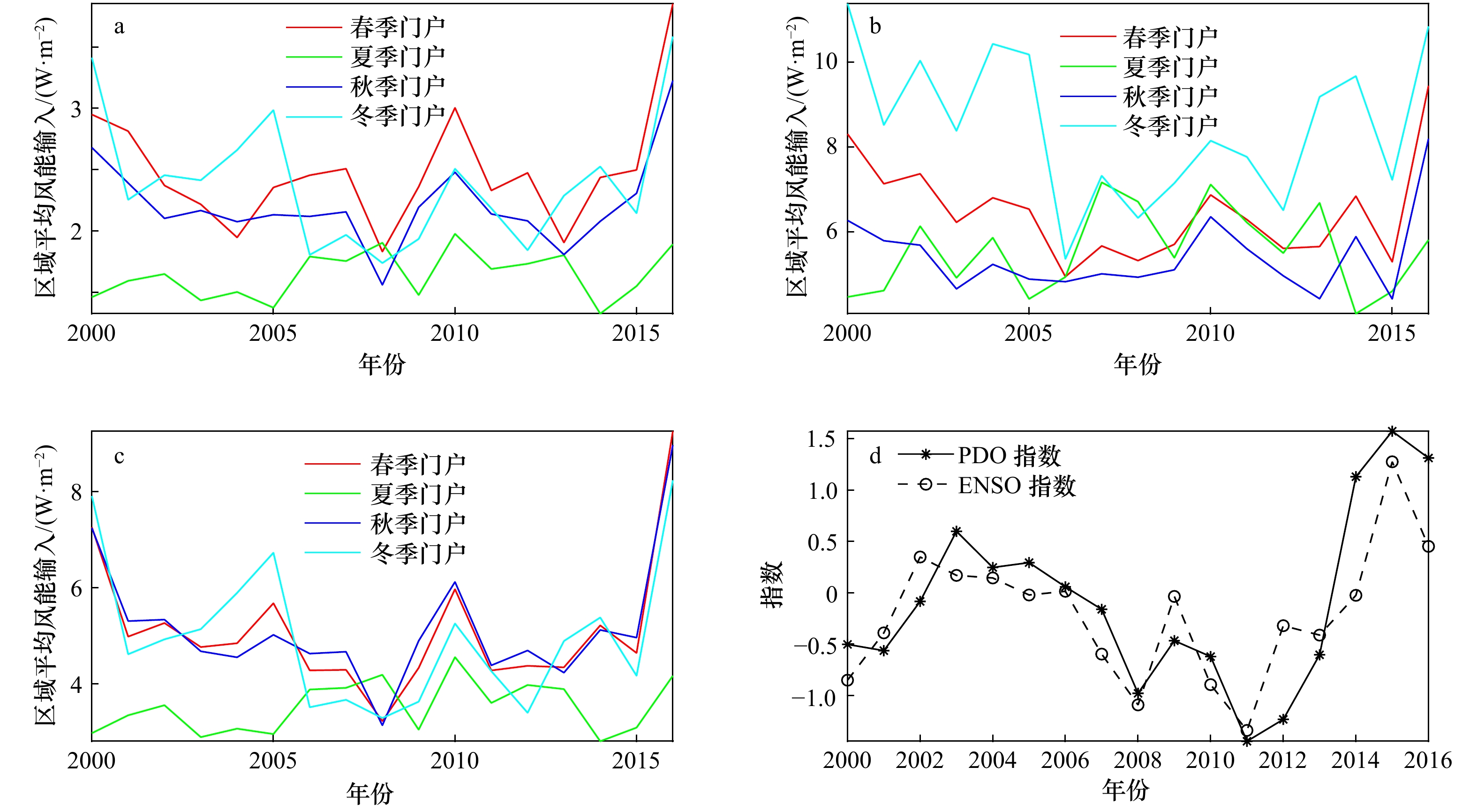
Wind not only drives the surface ocean circulations, but also provides the main source of kinetic energy for deep ocean movements. This study focuses on the wind energy input to the north part of the North Pacific, including wind energy input to surface wave, surface geostrophic currents and surface ageostrophic currents. Results based on SODA3 (2000–2016) data show that there are obvious seasonal wind energy input gateways, which are the Subpolar Gyre for spring and autumn, the Eastern Pacific for summer and the Kuroshio Extension for winter respectively. The winter gateway gains the most wind energy among the four seasonal gateways, which is about 3−5 times higher than others. Since the beginning of the 21st century, wind energy input in winter gateway has weakened significantly, while increased in spring gateway, but has not changed significantly in summer and autumn gateway. For the spatial distribution of the trend in the 17 years, wind energy input to the surface wave is mainly dominated by the wind field, while wind energy input to the surface geostrophic current and ageostrophic current is dominated by the flow field. These mechanical energy input results are important for further understanding the ocean circulations in the North Pacific.
Wind not only drives the surface ocean circulations, but also provides the main source of kinetic energy for deep ocean movements. This study focuses on the wind energy input to the north part of the North Pacific, including wind energy input to surface wave, surface geostrophic currents and surface ageostrophic currents. Results based on SODA3 (2000–2016) data show that there are obvious seasonal wind energy input gateways, which are the Subpolar Gyre for spring and autumn, the Eastern Pacific for summer and the Kuroshio Extension for winter respectively. The winter gateway gains the most wind energy among the four seasonal gateways, which is about 3−5 times higher than others. Since the beginning of the 21st century, wind energy input in winter gateway has weakened significantly, while increased in spring gateway, but has not changed significantly in summer and autumn gateway. For the spatial distribution of the trend in the 17 years, wind energy input to the surface wave is mainly dominated by the wind field, while wind energy input to the surface geostrophic current and ageostrophic current is dominated by the flow field. These mechanical energy input results are important for further understanding the ocean circulations in the North Pacific.


2021, 43(3): 48-61.
doi: 10.12284/hyxb2021055
Abstract:
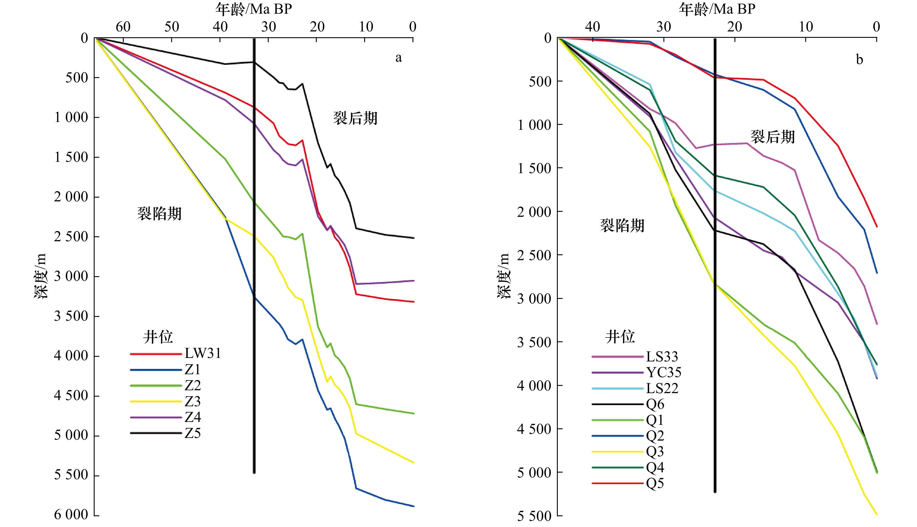
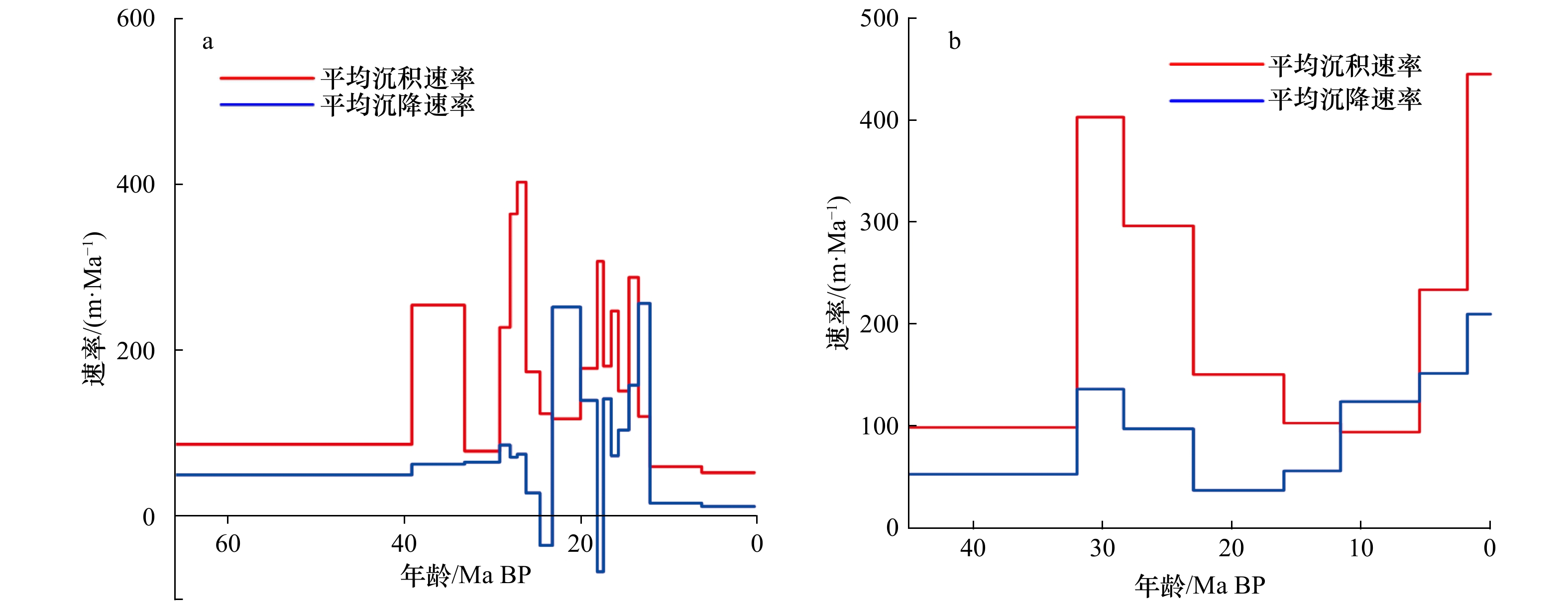
The formation and evolution of the South China Sea is well recorded in the northern continental margin. But the discrepancies of the tectonic and sedimentary evolution between the west and east of the northern margin are still enigmatic. Several drilling and simulation wells with analogous geological setting are chosen from the deep water areas of the Zhujiang River Estuary Basin and the Qiongdongnan Basin. Based on backstripping and previous studies, high resolution sedimentation rates and subsidence rates are constructed. Results show that both two basins are characterized by analogous sedimentation rates and subsidence rates in the syn-rift stage, but significant discrepancies are revealed in the post-rift stage. Episodic sedimentary and tectonic evolution characteristics are revealed in the Zhujiang River Estuary Basin, sedimentation rates are characterized by “two rapid sedimentation periods and three slow sedimentation periods” and subsidence rates are characterized by “two rapid subsidence periods and one slow subsidence period”. But the sedimentation rates are characterized by “graben” style evolution, and the subsidence rates are characterized by “step-up” style evolution in the Qiongdongnan Basin. The “step-up” subsidence rates in the Qiongdongnan Basin might be controlled by activities of the Hainan mantle plume which moved northwestward derived from the dextral strike-slip of the Red River Fault. And it coincided with the magmatism and the subsidence rate in the northwest margin of the South China Sea. The distribution of the rapid deposition and accelerated subsidence in the Qiongdongnan Basin after 1.8 Ma BP could be mainly controlled by the meanwhile dextral strike-slip of the Red River Fault.
The formation and evolution of the South China Sea is well recorded in the northern continental margin. But the discrepancies of the tectonic and sedimentary evolution between the west and east of the northern margin are still enigmatic. Several drilling and simulation wells with analogous geological setting are chosen from the deep water areas of the Zhujiang River Estuary Basin and the Qiongdongnan Basin. Based on backstripping and previous studies, high resolution sedimentation rates and subsidence rates are constructed. Results show that both two basins are characterized by analogous sedimentation rates and subsidence rates in the syn-rift stage, but significant discrepancies are revealed in the post-rift stage. Episodic sedimentary and tectonic evolution characteristics are revealed in the Zhujiang River Estuary Basin, sedimentation rates are characterized by “two rapid sedimentation periods and three slow sedimentation periods” and subsidence rates are characterized by “two rapid subsidence periods and one slow subsidence period”. But the sedimentation rates are characterized by “graben” style evolution, and the subsidence rates are characterized by “step-up” style evolution in the Qiongdongnan Basin. The “step-up” subsidence rates in the Qiongdongnan Basin might be controlled by activities of the Hainan mantle plume which moved northwestward derived from the dextral strike-slip of the Red River Fault. And it coincided with the magmatism and the subsidence rate in the northwest margin of the South China Sea. The distribution of the rapid deposition and accelerated subsidence in the Qiongdongnan Basin after 1.8 Ma BP could be mainly controlled by the meanwhile dextral strike-slip of the Red River Fault.


2021, 43(3): 62-75.
doi: 10.12284/hyxb2021045
Abstract:
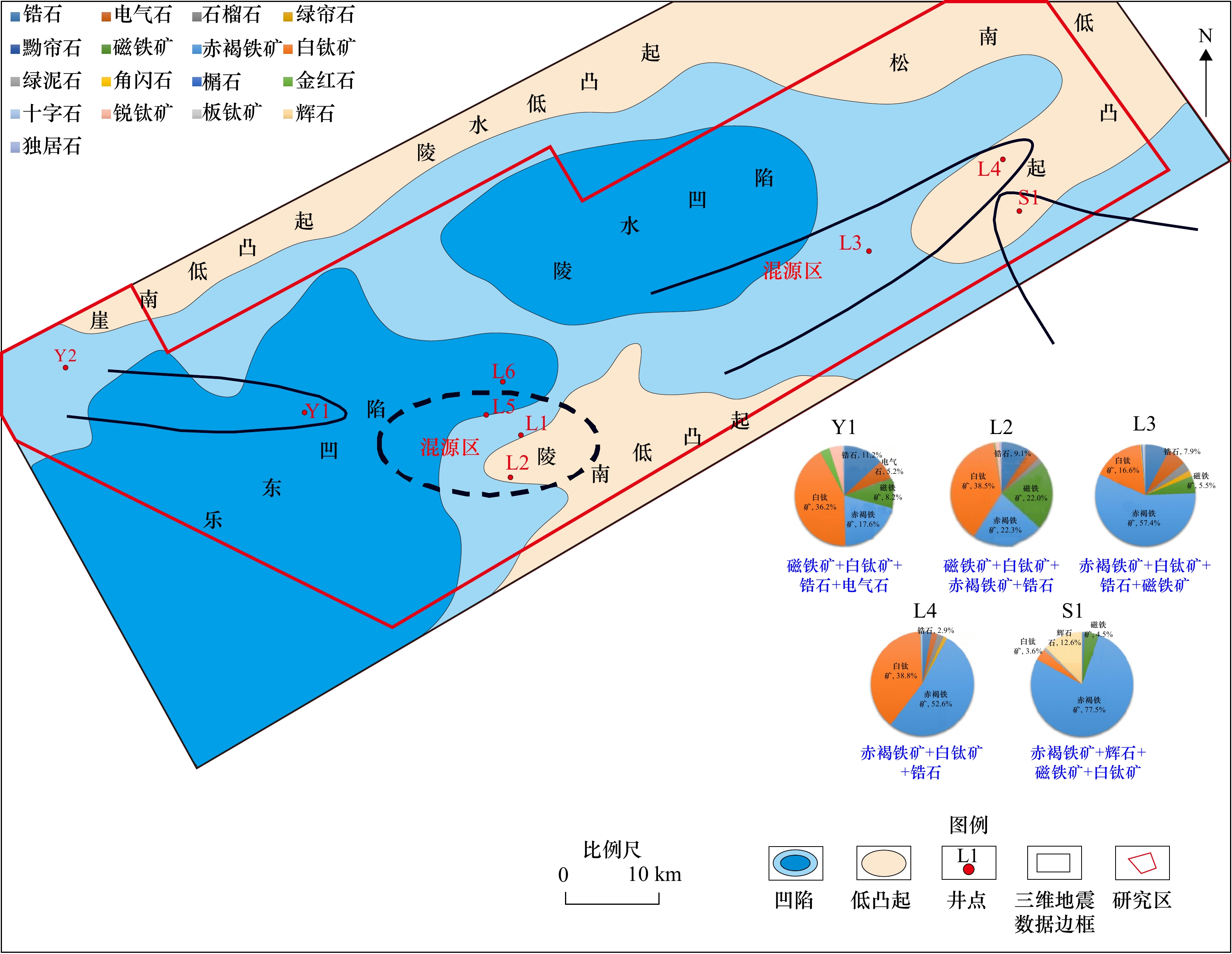
In recent years, several deep-water gas fields of Yinggehai Formation have been discovered in ultra-deep water area of Qiongdongnan Basin, showing a broad exploration prospect. However, the reservoir physical property prediction of the Member 2 of Neogene Yinggehai Formation have become increasingly prominent which seriously restricts the further exploration of oil and gas. Based on the regional geological data summarized by predecessors, combined with core, logging and three-dimensional seismic data, the third-order sequence framework of the Member 2 of Neogene Yinggehai Formation is established, and the provenance systems in the sequence framework and the sedimentary characteristics of gravity flow under its control are comprehensively analyzed. The results show that gravity flow sedimentary system mainly developed in Ⅱ2-ygh2c and Ⅱ2-ygh2b, and include three major provenance systems which are the south, the north and the axis. Different rovenance systems control the spatial distribution and sedimentary characteristics of gravity flow reservoirs. (1)The submarine canyons controlled by the south provenance are mainly filled by abyssal mudstone, while the canyons controlled by the north provenance are mainly filled with thick turbidite channel sandstone with fine porosity and permeability, which is a good reservoir. (2) The flood plain deposit affected by axial provenance can also be a good oil and gas reservoir because of its good physical properties. (3) The submarine fans controlled by the south provenance is characterized by thin sandstone with fine grain size and high argillaceous content. While the submarine canyons and fans controlled by the north and the axis provenance formed large scale sandstone with big thickness, coarse grain size and good reservoir physical properties, which are the most important high-quality gas-producing reservoirs of deep water area.
In recent years, several deep-water gas fields of Yinggehai Formation have been discovered in ultra-deep water area of Qiongdongnan Basin, showing a broad exploration prospect. However, the reservoir physical property prediction of the Member 2 of Neogene Yinggehai Formation have become increasingly prominent which seriously restricts the further exploration of oil and gas. Based on the regional geological data summarized by predecessors, combined with core, logging and three-dimensional seismic data, the third-order sequence framework of the Member 2 of Neogene Yinggehai Formation is established, and the provenance systems in the sequence framework and the sedimentary characteristics of gravity flow under its control are comprehensively analyzed. The results show that gravity flow sedimentary system mainly developed in Ⅱ2-ygh2c and Ⅱ2-ygh2b, and include three major provenance systems which are the south, the north and the axis. Different rovenance systems control the spatial distribution and sedimentary characteristics of gravity flow reservoirs. (1)The submarine canyons controlled by the south provenance are mainly filled by abyssal mudstone, while the canyons controlled by the north provenance are mainly filled with thick turbidite channel sandstone with fine porosity and permeability, which is a good reservoir. (2) The flood plain deposit affected by axial provenance can also be a good oil and gas reservoir because of its good physical properties. (3) The submarine fans controlled by the south provenance is characterized by thin sandstone with fine grain size and high argillaceous content. While the submarine canyons and fans controlled by the north and the axis provenance formed large scale sandstone with big thickness, coarse grain size and good reservoir physical properties, which are the most important high-quality gas-producing reservoirs of deep water area.


2021, 43(3): 76-89.
doi: 10.12284/hyxb2021041
Abstract:
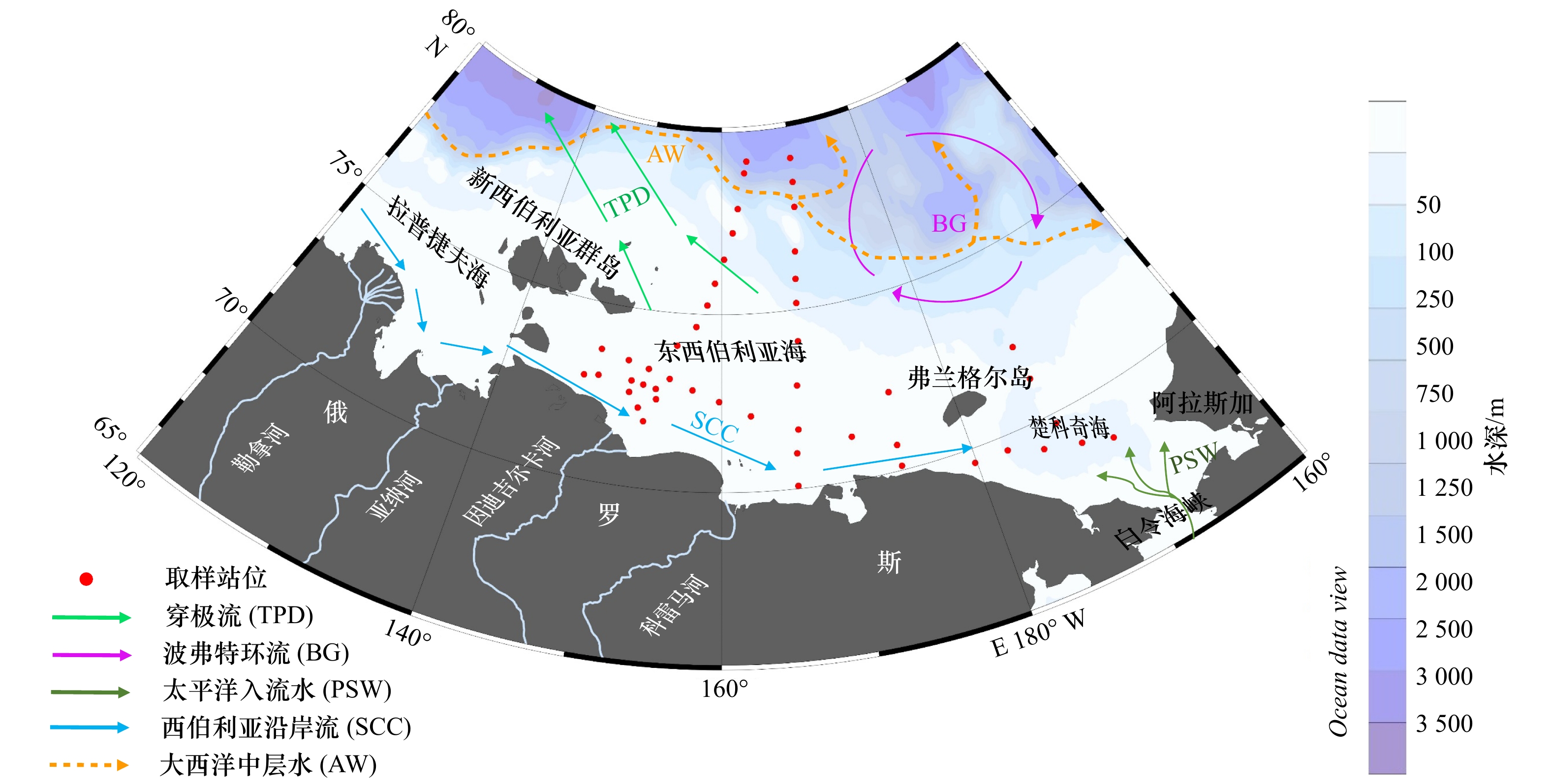
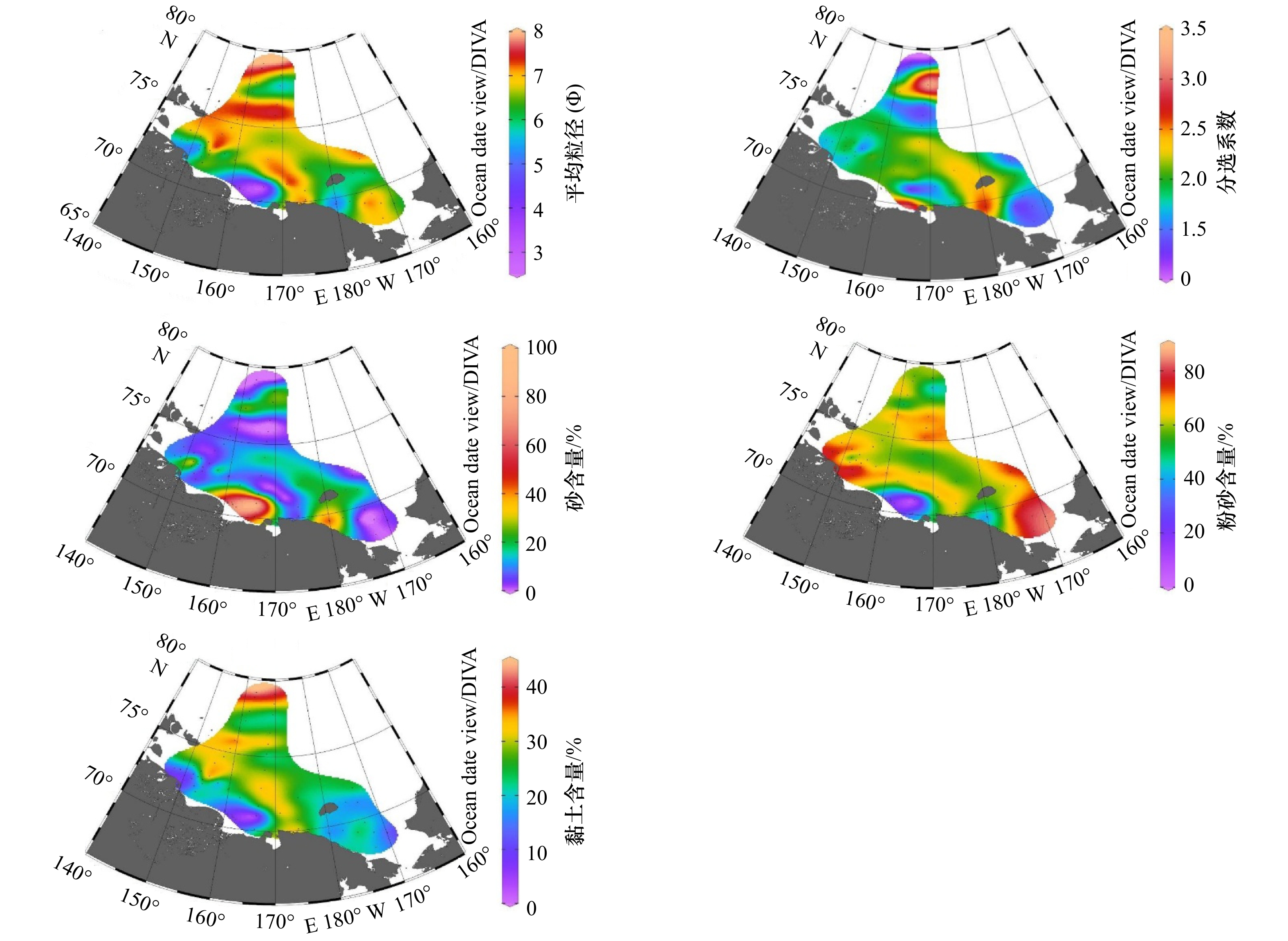
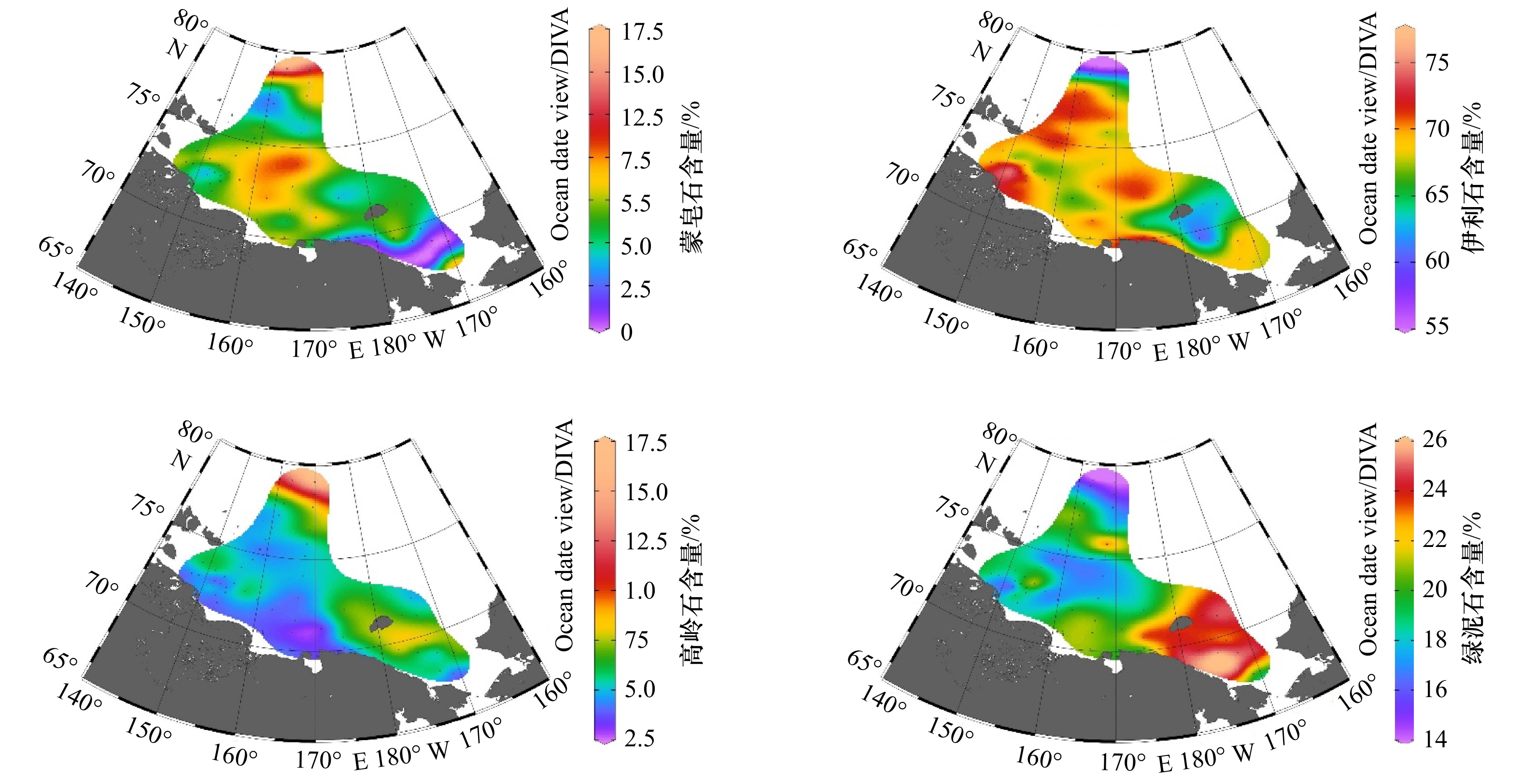
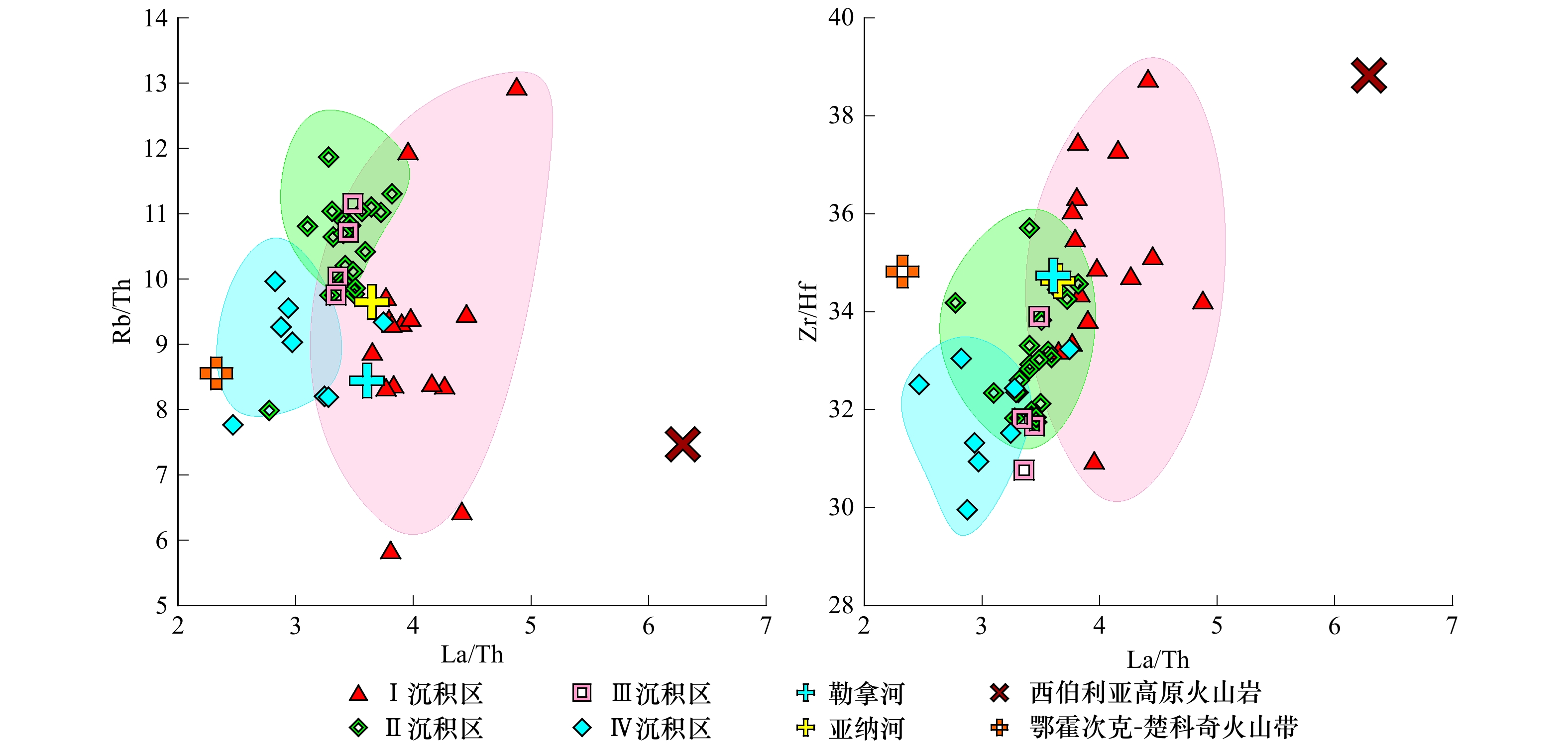
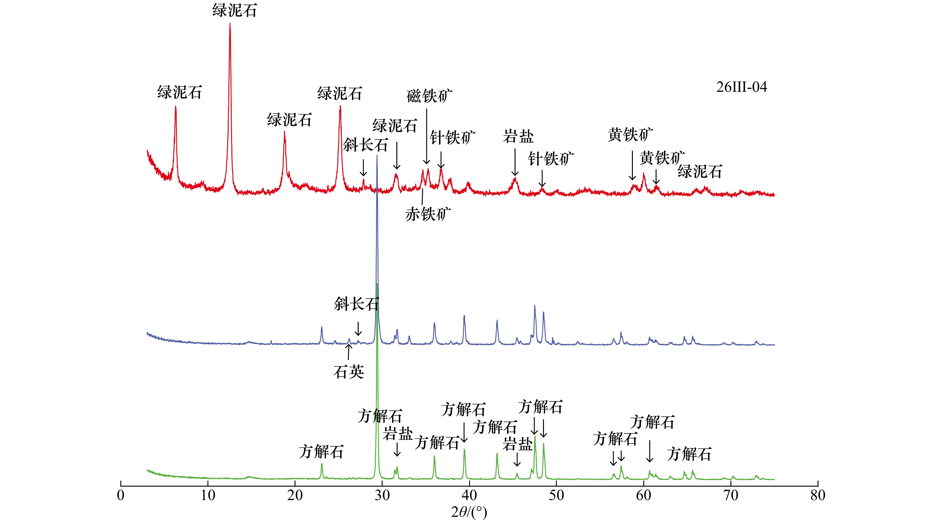
Grain size, clay minerals and major and trace elements of surface sediment samples collected from the East Siberian Arctic Shelf are analyzed. Based on factor analysis and cluster analysis the study area is divided into four provinces, the main sediment sources of each province are discussed. The results show that province I covers the estuary area of the Kolyma River and the Indigirka River. The sediments are mainly composed of silt and sandy silt, and characterized by higher content of SiO2, TiO2, Zr and low content of other elements. The ratios of La/Th and Zr/Hf reach the maximum in the four sedimentary areas. Illite is dominant which accounting for 70% of the whole clay minerals. This area is strongly influenced by terrestrial sources from the Kolyma River and the Indigirka River. Province II is located in the middle of the East Siberian Sea, where the sediments are generally silt and mud. The content of MnO, Ba, and Ni are relatively higher. La/Th and Zr/Hf ratio are slightly lower than that in Province I. Clay minerals composition is similar to Province I. The sediments in this area are mainly fine-grained derived by rivers, which are also influenced by sea ice process. As the distance increasing offshore, the content of marine authigenic components begin to increase. Province III is located in the northern East Siberian Sea, and sediments there are mainly mud. Elements such as Al2O3, K2O, V, Li reach the maximum value in this area. The La/Th and Rb/Th ratios are similar to those in the Province II. The content of illite is the lowest, semctite and kaolinite reach the maximum (>10%). Fine-grained sediments in this area are probably influenced by Atlantic waters and the Beaufort Gyre. Province IV is located in Chukchi Sea where the sediments consist of silt and sandy silt. Elements are characterized by higher contents of CaO, P2O5. The ratios of Rb/Th, La/Th and Zr/Hf are the minimum values, the content of chlorite reach peak (>20%). Sediments in this area are significantly influenced by the Pacific inflow water.
Grain size, clay minerals and major and trace elements of surface sediment samples collected from the East Siberian Arctic Shelf are analyzed. Based on factor analysis and cluster analysis the study area is divided into four provinces, the main sediment sources of each province are discussed. The results show that province I covers the estuary area of the Kolyma River and the Indigirka River. The sediments are mainly composed of silt and sandy silt, and characterized by higher content of SiO2, TiO2, Zr and low content of other elements. The ratios of La/Th and Zr/Hf reach the maximum in the four sedimentary areas. Illite is dominant which accounting for 70% of the whole clay minerals. This area is strongly influenced by terrestrial sources from the Kolyma River and the Indigirka River. Province II is located in the middle of the East Siberian Sea, where the sediments are generally silt and mud. The content of MnO, Ba, and Ni are relatively higher. La/Th and Zr/Hf ratio are slightly lower than that in Province I. Clay minerals composition is similar to Province I. The sediments in this area are mainly fine-grained derived by rivers, which are also influenced by sea ice process. As the distance increasing offshore, the content of marine authigenic components begin to increase. Province III is located in the northern East Siberian Sea, and sediments there are mainly mud. Elements such as Al2O3, K2O, V, Li reach the maximum value in this area. The La/Th and Rb/Th ratios are similar to those in the Province II. The content of illite is the lowest, semctite and kaolinite reach the maximum (>10%). Fine-grained sediments in this area are probably influenced by Atlantic waters and the Beaufort Gyre. Province IV is located in Chukchi Sea where the sediments consist of silt and sandy silt. Elements are characterized by higher contents of CaO, P2O5. The ratios of Rb/Th, La/Th and Zr/Hf are the minimum values, the content of chlorite reach peak (>20%). Sediments in this area are significantly influenced by the Pacific inflow water.


2021, 43(3): 90-104.
doi: 10.12284/hyxb2021057
Abstract:
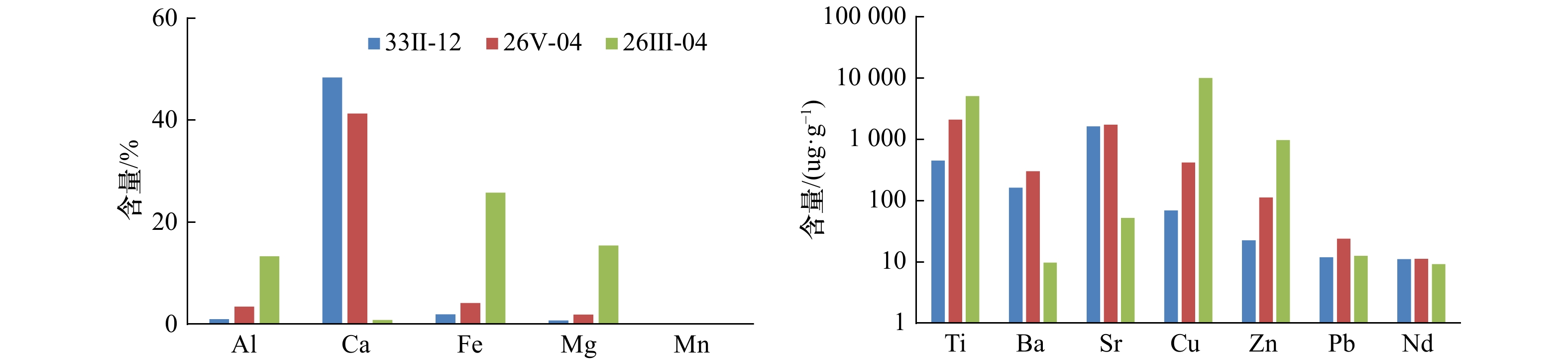
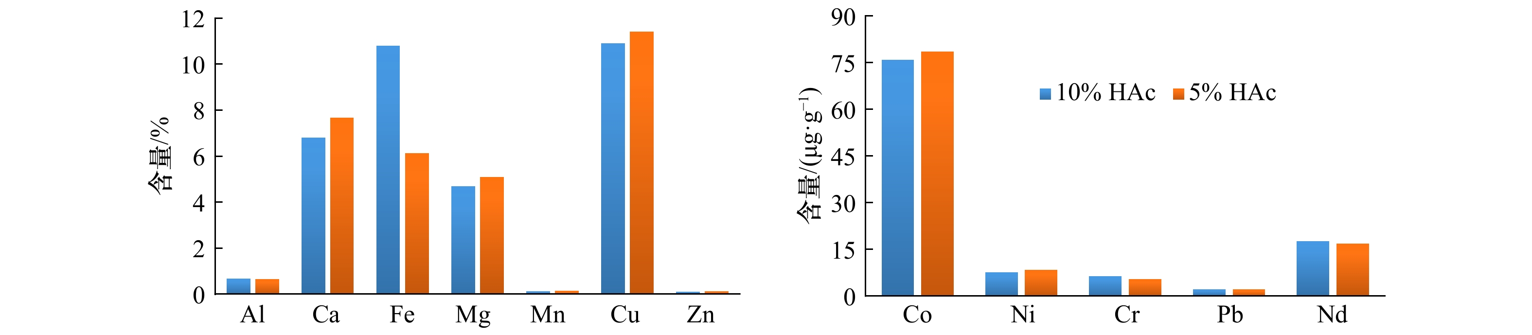
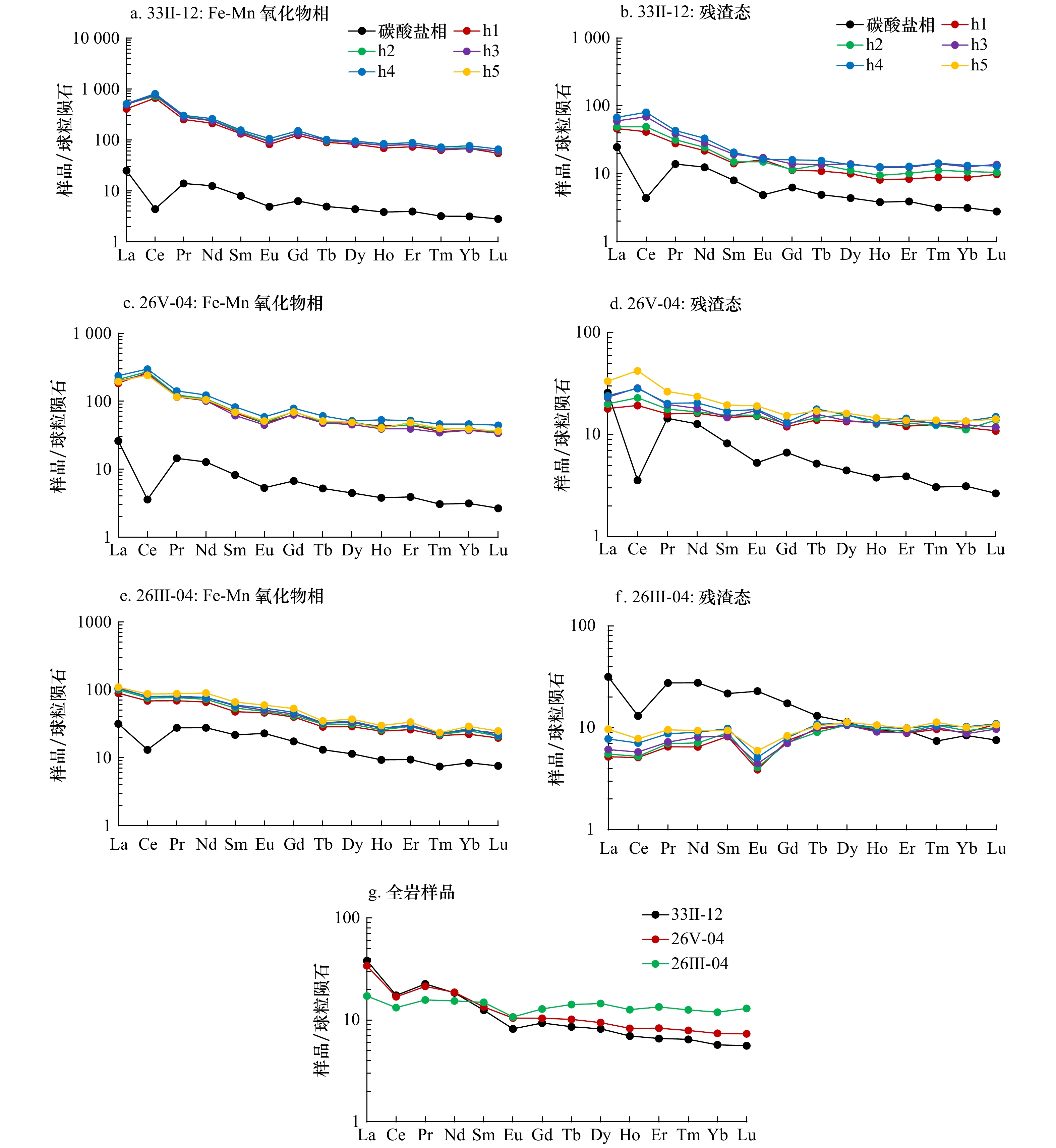
In this study, elemental and mineral compositions of three surface sediments collected from the South Atlantic Ridge affected by hydrothermal activities of various degrees were analyzed, and series of extraction experiments for carbonate phase, Fe-Mn oxide phase and insoluble residual phase were carried out. Mixed reagent of hydroxylamine hydrochloride (HH) with different concentrations and 25% acetic acid (HAc) were used to extract Fe-Mn oxide phase from the sample. In order to corroborate the reliability of the extracting methods, Ti/Nd and Ti/Pb ratios of the Fe-Mn oxide phase, rare earth elements (REE) patterns as well as δCe and δEu ratios of different chemical phase were used to determine that the ideal reagent conditions for extracting Fe-Mn oxide phase from three different types of hydrothermal sediments were all 0.5 mol/L HH in 25% acetic acid. The results show that the higher the degree of influence of hydrothermal activities, the higher the contents of Fe, Cu, Zn and other elements in the sediments, and the contents of Ca, Sr and Ba show an opposite trend. Manganese, Pb and REE are not significantly affected by hydrothermal activities. As the influence of hydrothermal activity increases, the proportion of Ca, Sr and Nd increases in the Fe-Mn oxide phase and decreases in the residual phase, while Mn, Co, Ni and Zn have an opposite trend, and the proportion of Cu increases in the carbonate phase and decreases in the residual phase. Lead is not affected by the influence strength of hydrothermal activity and mainly occurs in the Fe-Mn oxide phase. REE mainly occur in the residue state. The occurrence state of REE shows that the more significant influence by the hydrothermal activities of the sediments, the more enrichment of REE in the residual phase. And the chondrite-normalized REE patterns of the residual phase exhibit that the enrichment of light REE are less obvious. This study provides methods for extracting hydrothermal fractions and valuable geochemical data for further understanding of the characteristics of hydrothermal sediments and the effects of hydrothermal activities on the occurrence state of elements in the South Atlantic Ridge.
In this study, elemental and mineral compositions of three surface sediments collected from the South Atlantic Ridge affected by hydrothermal activities of various degrees were analyzed, and series of extraction experiments for carbonate phase, Fe-Mn oxide phase and insoluble residual phase were carried out. Mixed reagent of hydroxylamine hydrochloride (HH) with different concentrations and 25% acetic acid (HAc) were used to extract Fe-Mn oxide phase from the sample. In order to corroborate the reliability of the extracting methods, Ti/Nd and Ti/Pb ratios of the Fe-Mn oxide phase, rare earth elements (REE) patterns as well as δCe and δEu ratios of different chemical phase were used to determine that the ideal reagent conditions for extracting Fe-Mn oxide phase from three different types of hydrothermal sediments were all 0.5 mol/L HH in 25% acetic acid. The results show that the higher the degree of influence of hydrothermal activities, the higher the contents of Fe, Cu, Zn and other elements in the sediments, and the contents of Ca, Sr and Ba show an opposite trend. Manganese, Pb and REE are not significantly affected by hydrothermal activities. As the influence of hydrothermal activity increases, the proportion of Ca, Sr and Nd increases in the Fe-Mn oxide phase and decreases in the residual phase, while Mn, Co, Ni and Zn have an opposite trend, and the proportion of Cu increases in the carbonate phase and decreases in the residual phase. Lead is not affected by the influence strength of hydrothermal activity and mainly occurs in the Fe-Mn oxide phase. REE mainly occur in the residue state. The occurrence state of REE shows that the more significant influence by the hydrothermal activities of the sediments, the more enrichment of REE in the residual phase. And the chondrite-normalized REE patterns of the residual phase exhibit that the enrichment of light REE are less obvious. This study provides methods for extracting hydrothermal fractions and valuable geochemical data for further understanding of the characteristics of hydrothermal sediments and the effects of hydrothermal activities on the occurrence state of elements in the South Atlantic Ridge.

2021, 43(3): 105-115.
doi: 10.12284/hyxb2021025
Abstract:
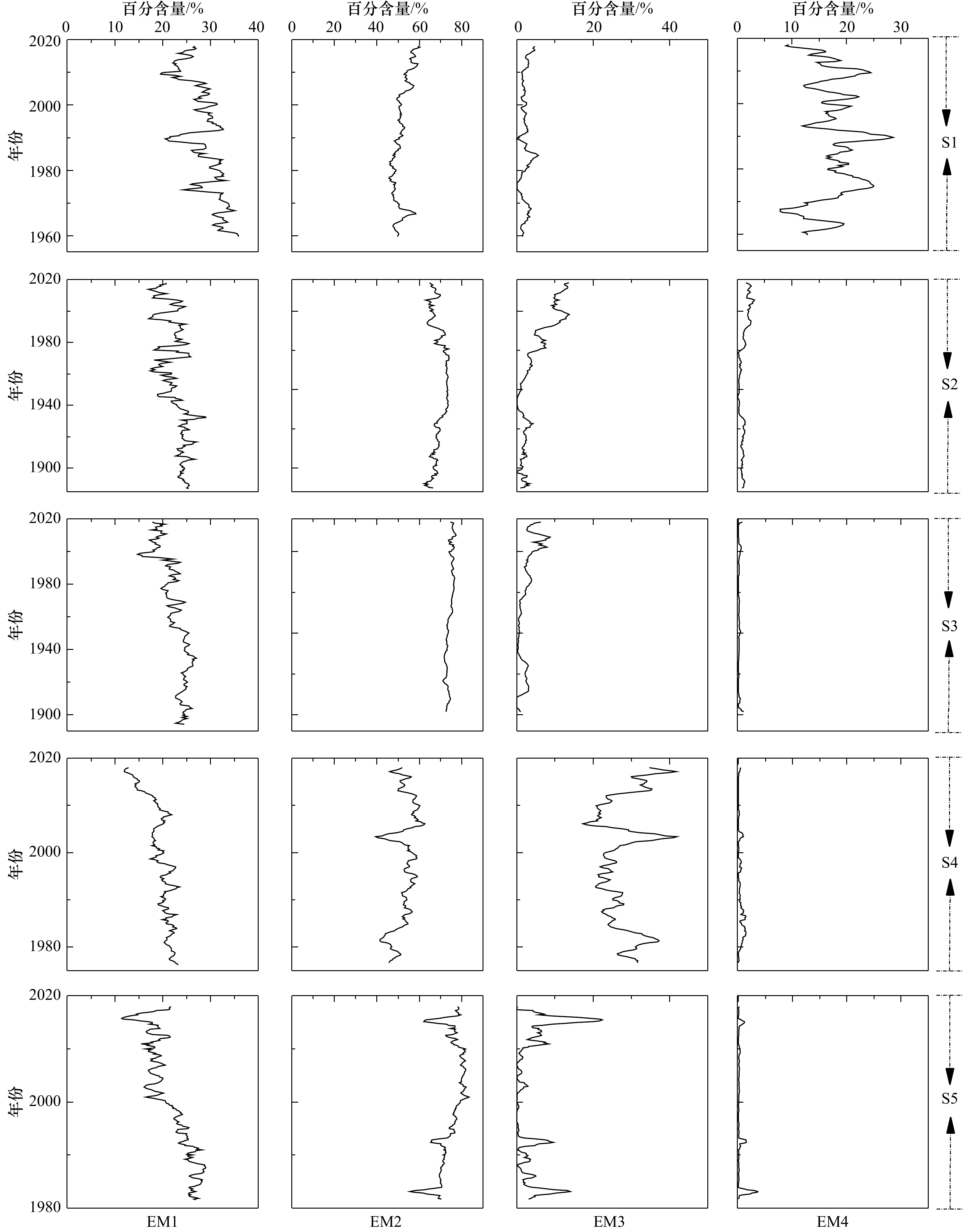
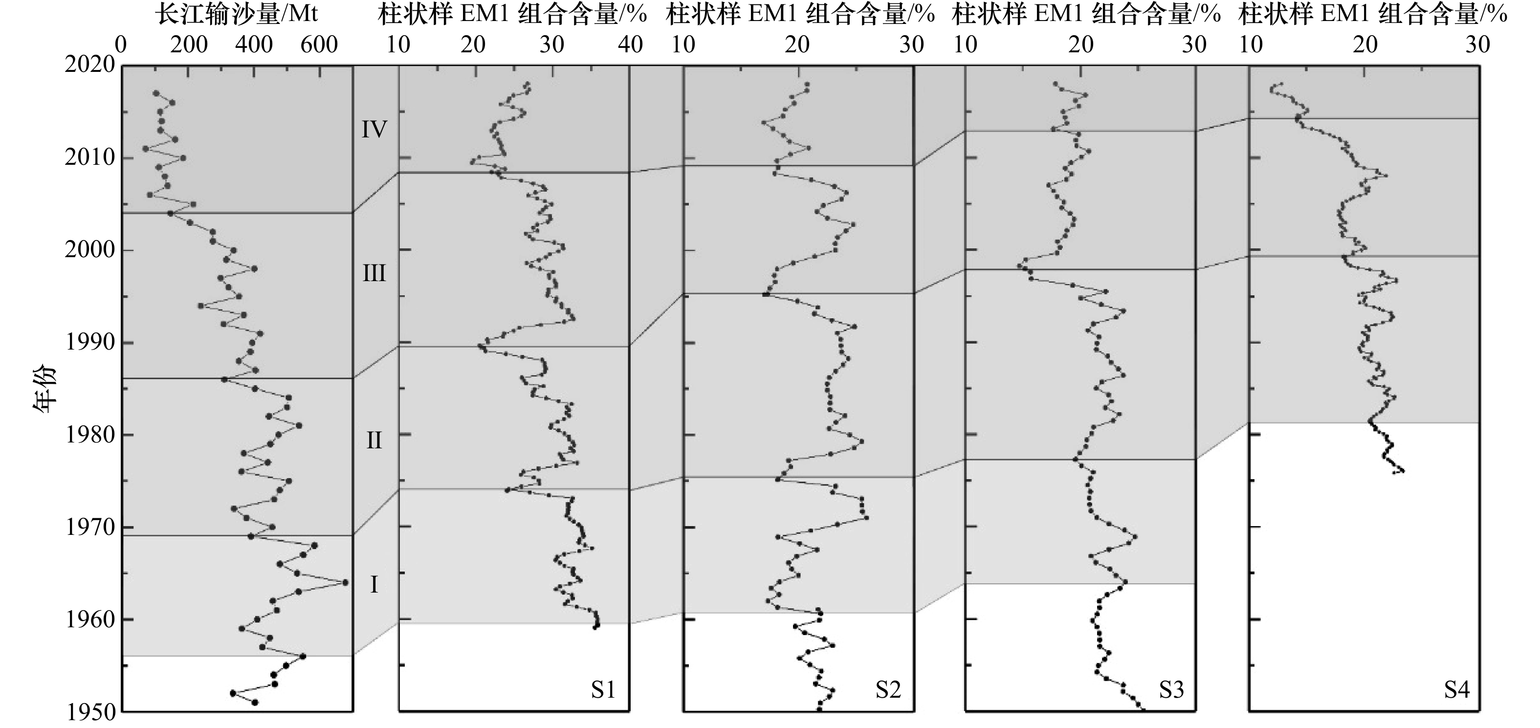
Since 1950, the sediment load of the Changjiang River entering the sea has been stepwise decreasing. As the distal mud of the Changjiang River, whether the signal of “sediment load reduction” was recorded in the Zhe-Min coastal mud? If so, how to extract and interpret these sedimentary information? In order to discussing this scientific problem, 5 sediment cores were collected in the Zhe-Min coastal mud; in addition, high resolution grain size analysis (2 mm) was conducted, and four end members were obtained through end-member (EM) model decomposing. Combined with the analysis of the spatial discrepancy in provenance and hydrodynamics of the study area, the specific indicative significance of each EM was revealed: EM1 (with the modal grain size about 2 μm) is originated from extremely fine-grained sediment of the Changjiang River; EM2’s (with the modal grain size about 10 μm) origin is predominated by the Changjiang River, and small part is contributed by the middle and small sized rivers of Zhe-Min coast; EM3 (with the modal grain size about 80 μm) mainly consists of coarse-grain sediment might be provided by Taiwan Warm Current; EM4 (with the modal grain size about 200 μm) is also characterized by coarse-grain sediment, and may be contributed by the Changjiang River. Further analysis indicated that, the EM1 variation was in agreement with the sediment stepwise reduction of the Changjiang River; however, the response intensity gradually decreased from the north to the south. In addition, the hysteresis existed in response time, and the retardation time increased from 4−6 years in the north to 10−14 years in the south. In general, fine-grained sediment could better reflect the Changjiang River catchment change information, and response intensity exhibited significant difference in different areas of the Zhe-Min coastal mud.
Since 1950, the sediment load of the Changjiang River entering the sea has been stepwise decreasing. As the distal mud of the Changjiang River, whether the signal of “sediment load reduction” was recorded in the Zhe-Min coastal mud? If so, how to extract and interpret these sedimentary information? In order to discussing this scientific problem, 5 sediment cores were collected in the Zhe-Min coastal mud; in addition, high resolution grain size analysis (2 mm) was conducted, and four end members were obtained through end-member (EM) model decomposing. Combined with the analysis of the spatial discrepancy in provenance and hydrodynamics of the study area, the specific indicative significance of each EM was revealed: EM1 (with the modal grain size about 2 μm) is originated from extremely fine-grained sediment of the Changjiang River; EM2’s (with the modal grain size about 10 μm) origin is predominated by the Changjiang River, and small part is contributed by the middle and small sized rivers of Zhe-Min coast; EM3 (with the modal grain size about 80 μm) mainly consists of coarse-grain sediment might be provided by Taiwan Warm Current; EM4 (with the modal grain size about 200 μm) is also characterized by coarse-grain sediment, and may be contributed by the Changjiang River. Further analysis indicated that, the EM1 variation was in agreement with the sediment stepwise reduction of the Changjiang River; however, the response intensity gradually decreased from the north to the south. In addition, the hysteresis existed in response time, and the retardation time increased from 4−6 years in the north to 10−14 years in the south. In general, fine-grained sediment could better reflect the Changjiang River catchment change information, and response intensity exhibited significant difference in different areas of the Zhe-Min coastal mud.


2021, 43(3): 116-125.
doi: 10.12284/hyxb2021051
Abstract:
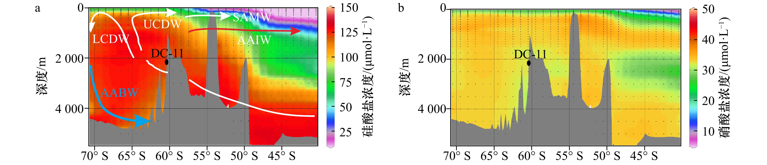
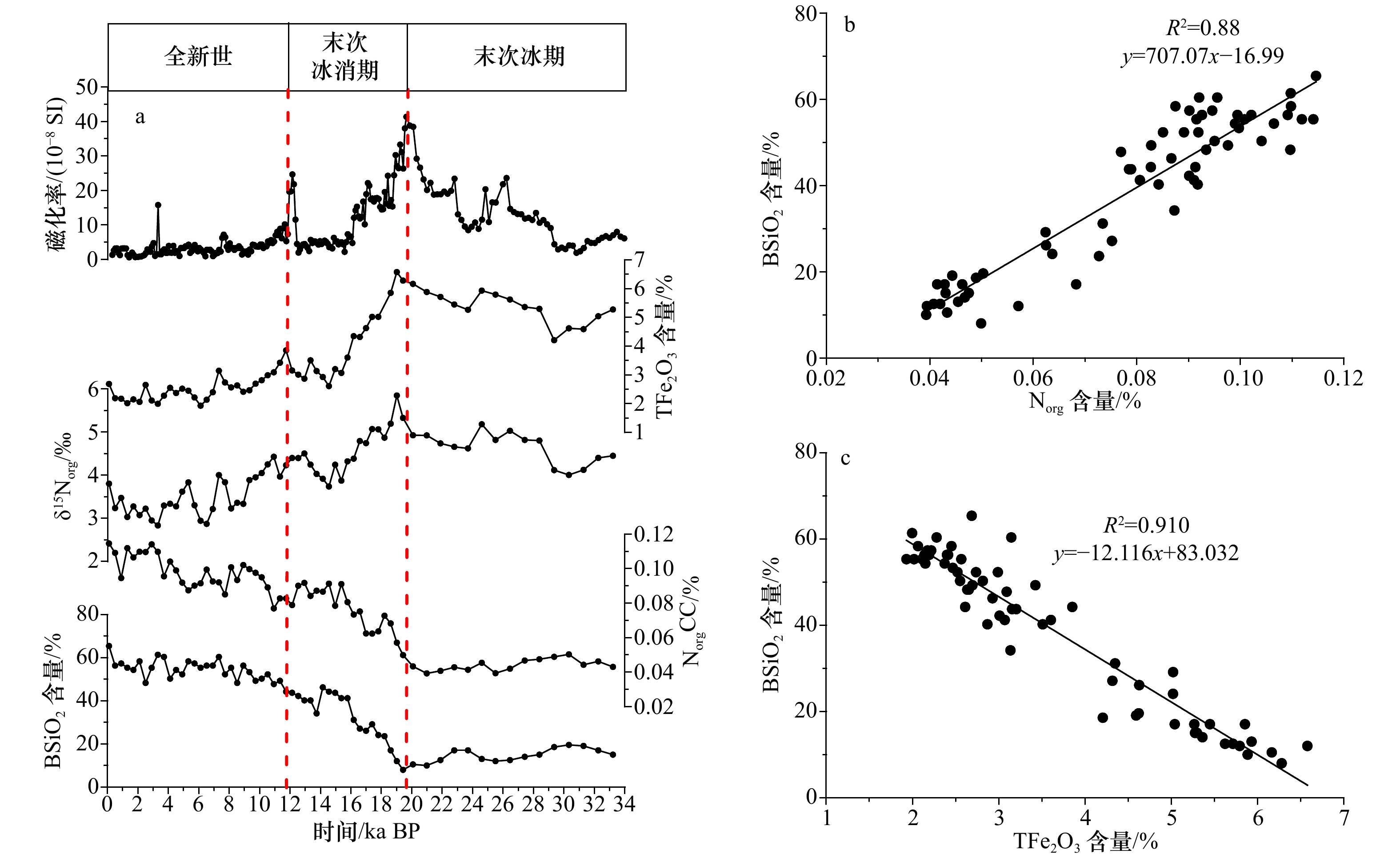
Paleoproductivity and environmental evolution since 34 ka BP in the southeastern Scotia Sea, Antarctica were reconstructed by the chronological analyses of biogenic opal (BSiO2), organic nitrogen (Norg), TFe2O3 and organic nitrogen isotopes (δ15Norg) in Core DC-11. Changes in BSiO2 and Norg contents are basically consistent with the Antarctic temperature, being higher in warm times. δ15Norg is coincident with the Antarctic sea ice, being greater and reflecting enhanced nitrate utilization in surface water during cold periods. From Last Glacial, Last Deglaciation to Holocene, paleoproductivity and environment changed significantly, and the millennial variability such as the Antarctic Cold Reversal (ACR) is prominent in the study area. Sea ice plays an important role in correlations between the climate, nutrients and paleoproductivity. The increase of sea ice during the glacial or cold periods caused stronger stratification of surface waters, weaker upwelling of deep waters and their dissolved nutrients to the surface ocean, and then resulted in enhanced nitrate utilization and lower paleoproductivity in surface water. Iron supply in the study area is sufficient in present-day and Holocene while it is excessive during Last Glacial and Last Deglaciation due to more developed dust, which is obviously different from that in the Subantarctic Zone.
Paleoproductivity and environmental evolution since 34 ka BP in the southeastern Scotia Sea, Antarctica were reconstructed by the chronological analyses of biogenic opal (BSiO2), organic nitrogen (Norg), TFe2O3 and organic nitrogen isotopes (δ15Norg) in Core DC-11. Changes in BSiO2 and Norg contents are basically consistent with the Antarctic temperature, being higher in warm times. δ15Norg is coincident with the Antarctic sea ice, being greater and reflecting enhanced nitrate utilization in surface water during cold periods. From Last Glacial, Last Deglaciation to Holocene, paleoproductivity and environment changed significantly, and the millennial variability such as the Antarctic Cold Reversal (ACR) is prominent in the study area. Sea ice plays an important role in correlations between the climate, nutrients and paleoproductivity. The increase of sea ice during the glacial or cold periods caused stronger stratification of surface waters, weaker upwelling of deep waters and their dissolved nutrients to the surface ocean, and then resulted in enhanced nitrate utilization and lower paleoproductivity in surface water. Iron supply in the study area is sufficient in present-day and Holocene while it is excessive during Last Glacial and Last Deglaciation due to more developed dust, which is obviously different from that in the Subantarctic Zone.


2021, 43(3): 126-134.
doi: 10.12284/hyxb2021001
Abstract:
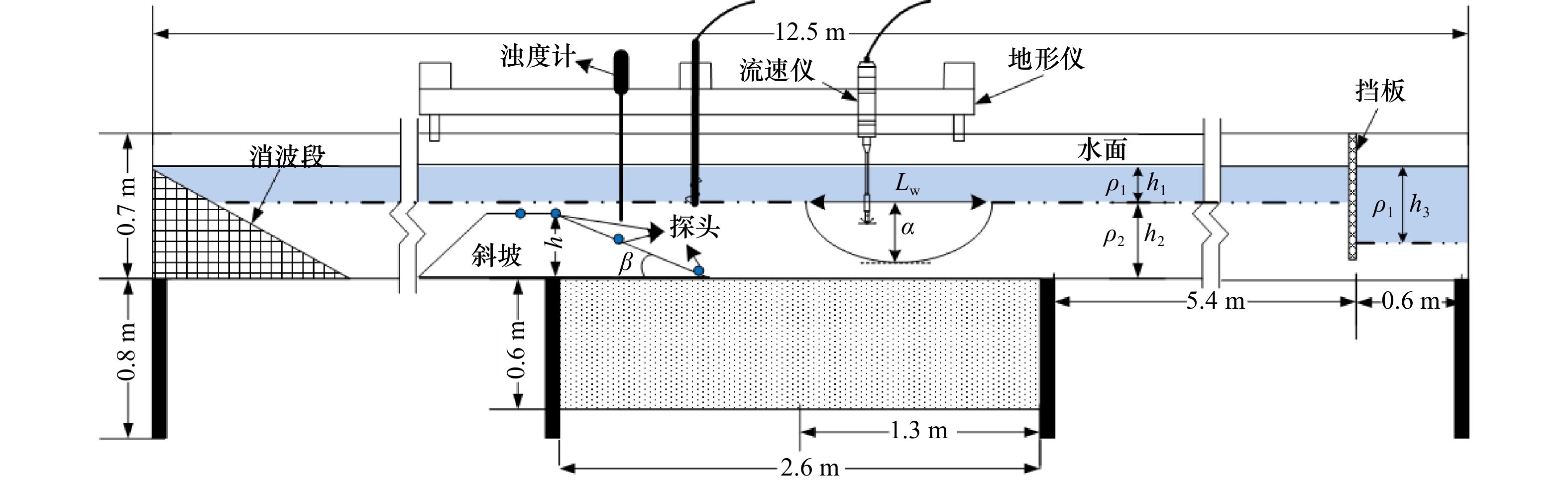
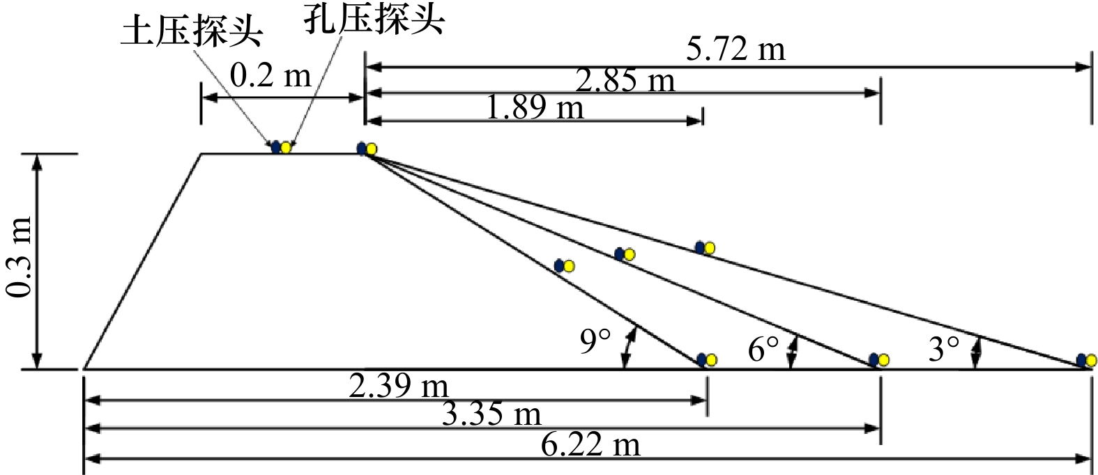
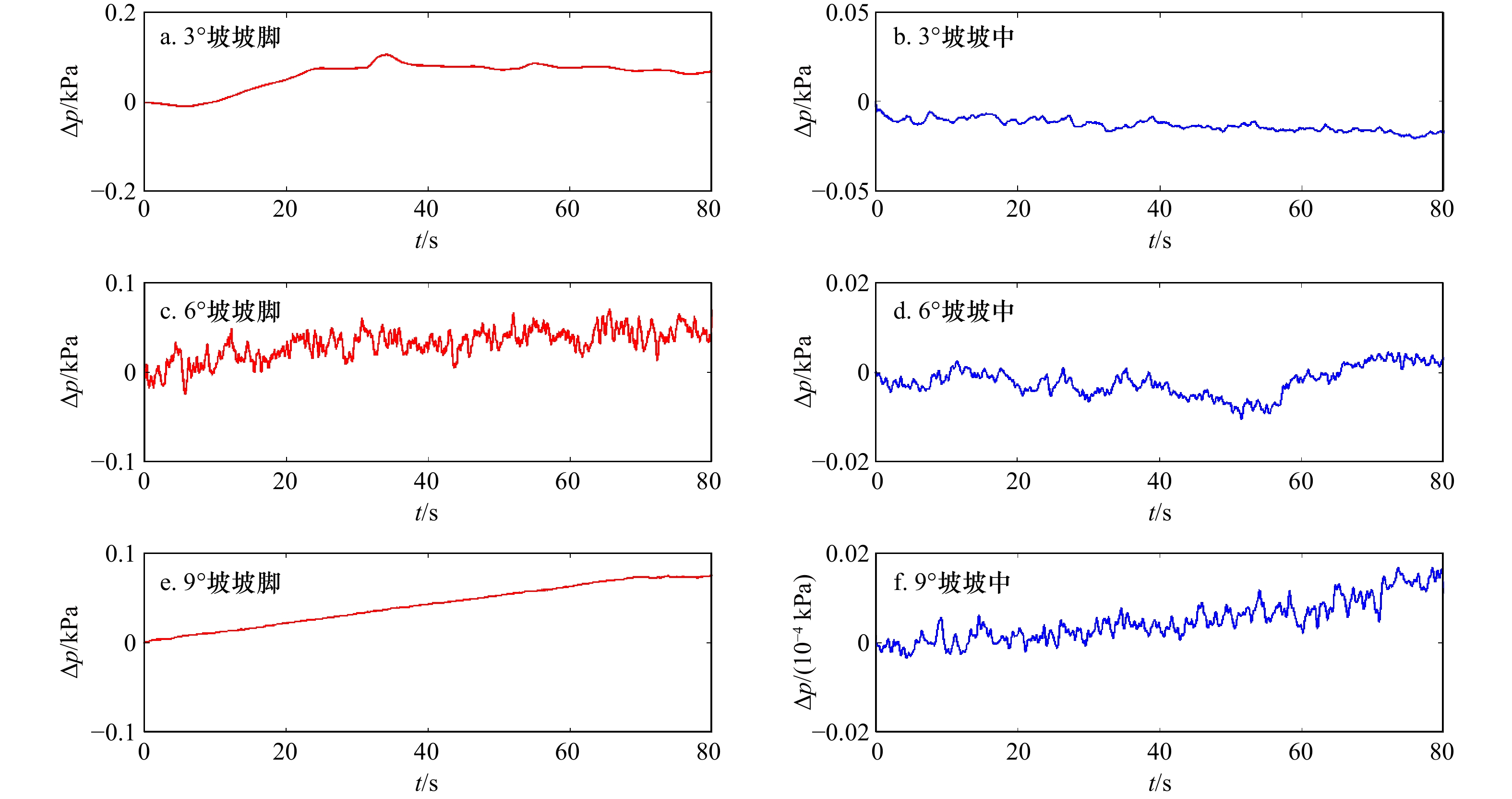
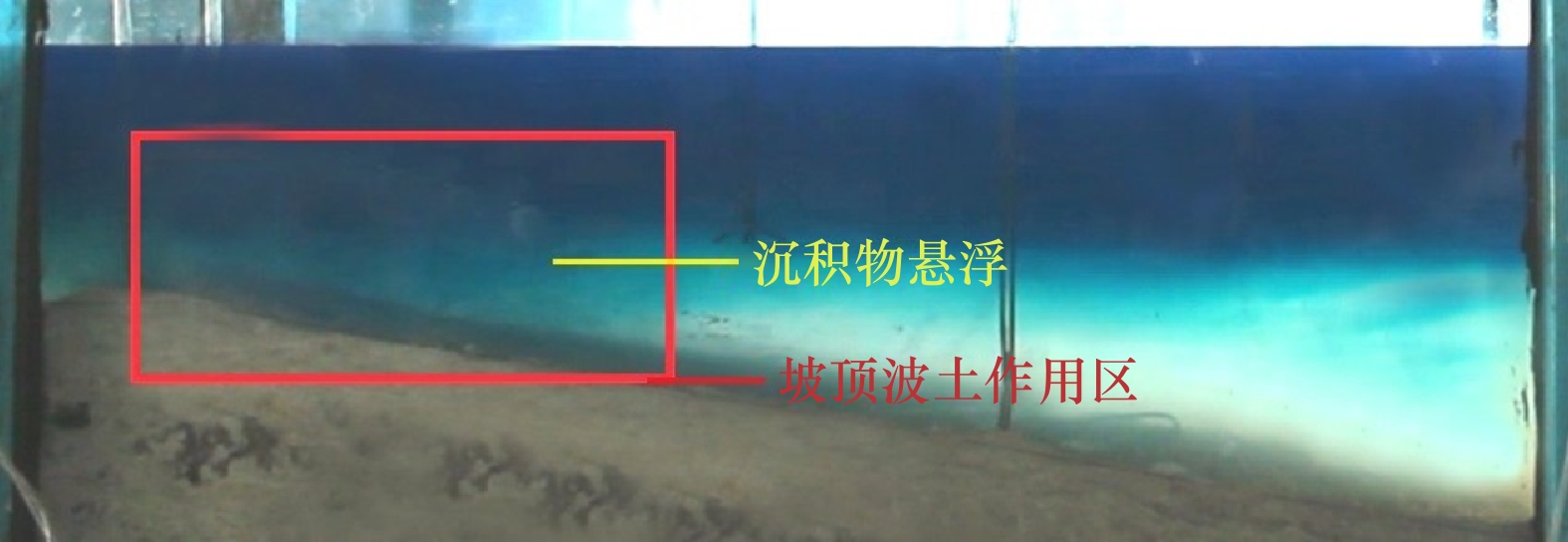
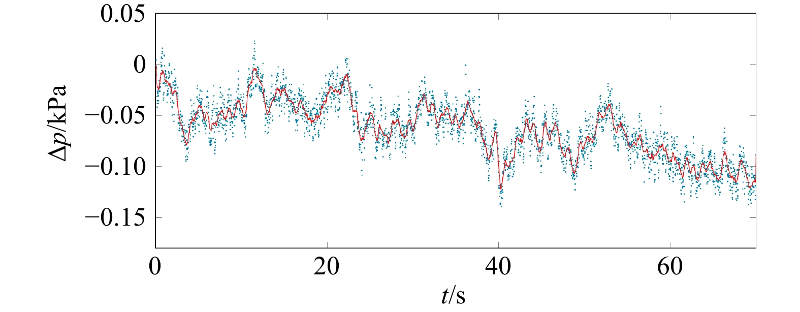
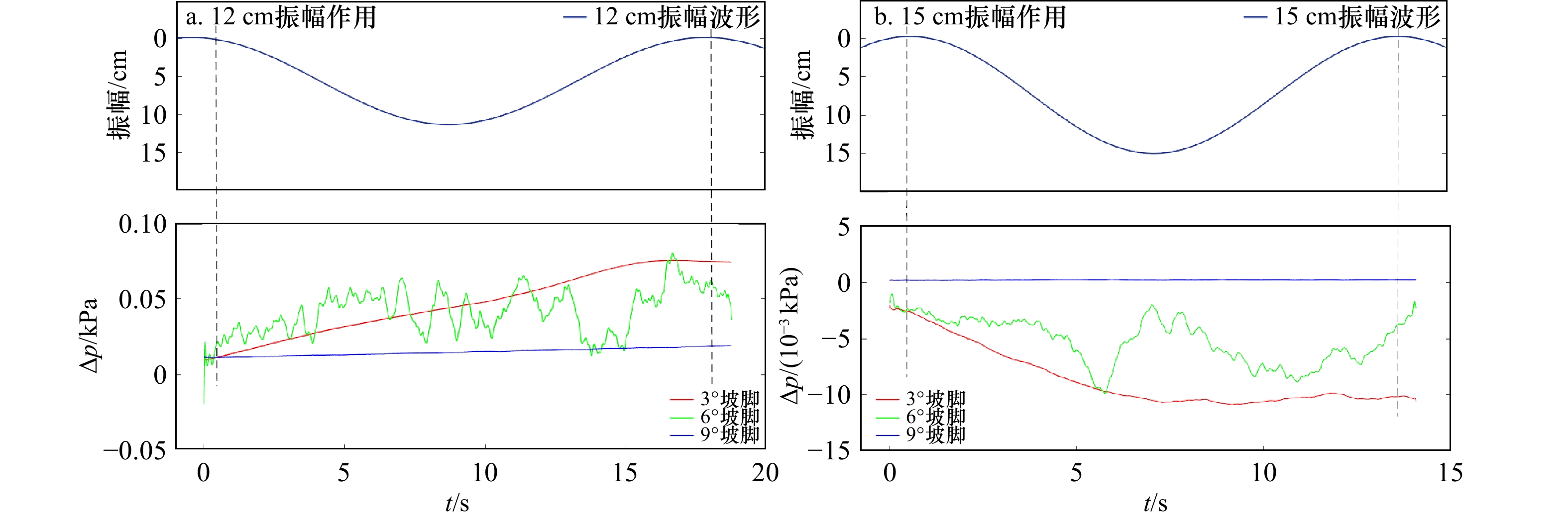
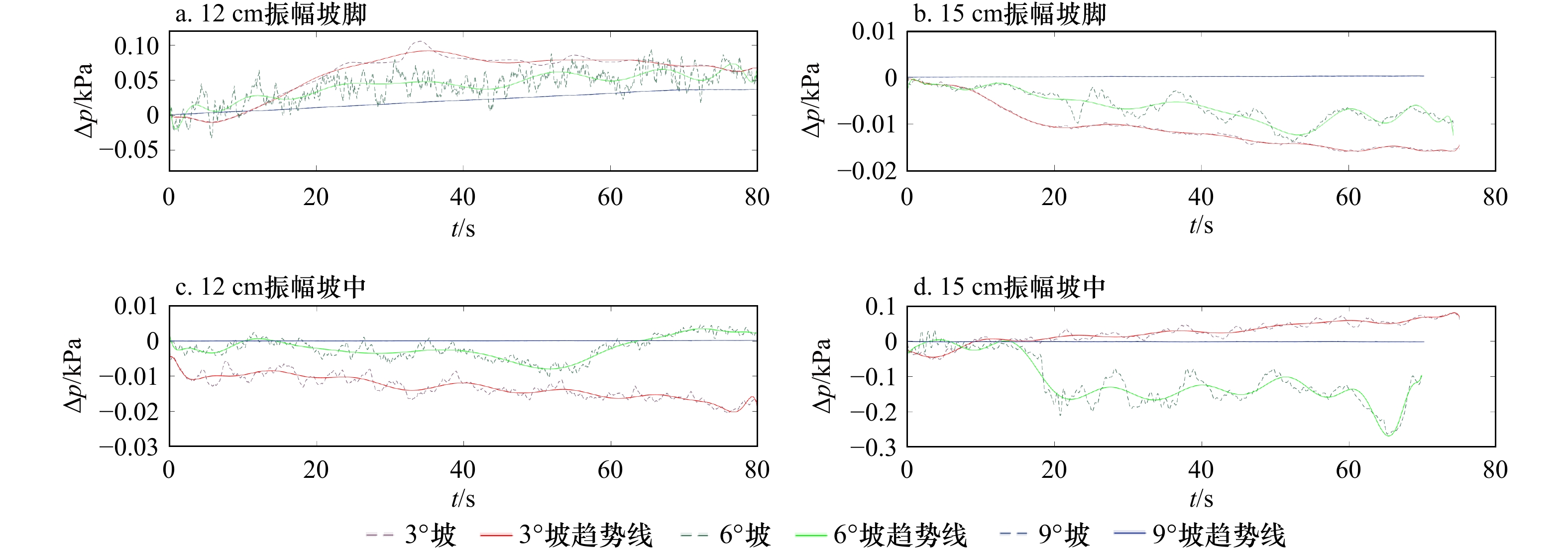
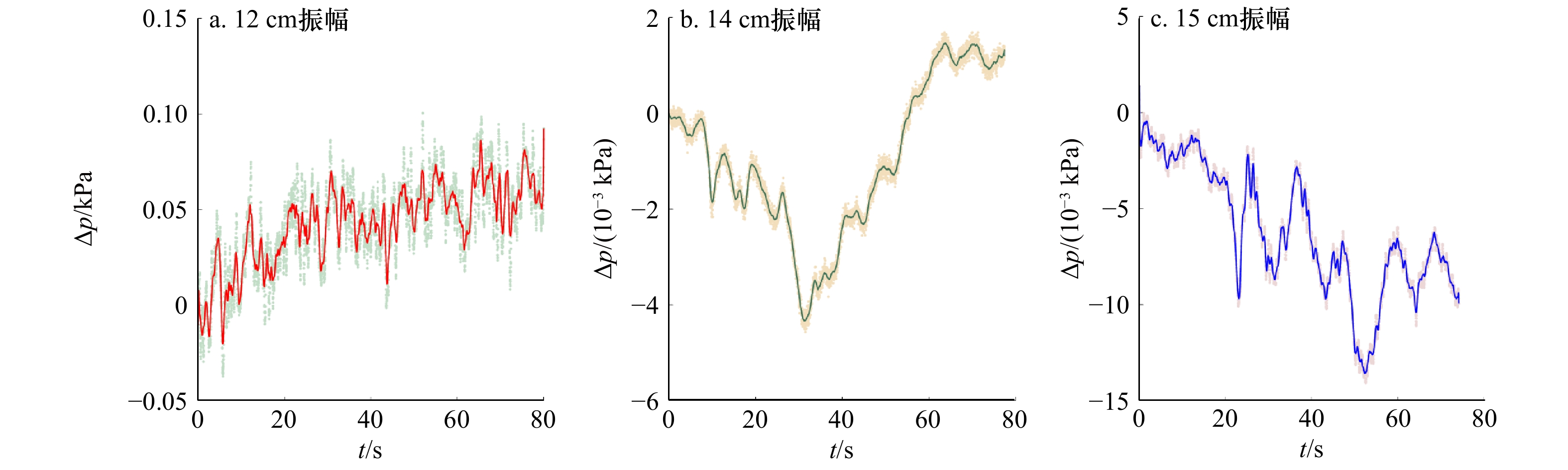
In view of the effect of internal solitary waves on the seafloor when encountering the seabed slope during their travel, the dynamic response of different slopes to internal solitary waves should be different. This paper studies the dynamic response process of internal solitary waves of slopes with different angles by creating internal waves in a flume. The results show that the internal solitary waves passing over the shelf slope will cause the accumulation of excess pore water pressure in the slope sediments; under the same amplitude conditions, the dynamic response amplitude of the gentle slope sediments is larger than that of the steep slope sediments; as the amplitude increases, gentle slopes occur the degree of dynamic damage is greater than that of steep slopes; the accumulation and release of excess pore water pressure exist at the same time before the stability of slope sediments is destroyed, and the increase of the amplitude of internal solitary waves will aggravate the release of excess pore water pressure. The results will play a guiding role in the dynamic study of the failure of slope sediment under the action of internal solitary waves and the analysis of slope stability.
In view of the effect of internal solitary waves on the seafloor when encountering the seabed slope during their travel, the dynamic response of different slopes to internal solitary waves should be different. This paper studies the dynamic response process of internal solitary waves of slopes with different angles by creating internal waves in a flume. The results show that the internal solitary waves passing over the shelf slope will cause the accumulation of excess pore water pressure in the slope sediments; under the same amplitude conditions, the dynamic response amplitude of the gentle slope sediments is larger than that of the steep slope sediments; as the amplitude increases, gentle slopes occur the degree of dynamic damage is greater than that of steep slopes; the accumulation and release of excess pore water pressure exist at the same time before the stability of slope sediments is destroyed, and the increase of the amplitude of internal solitary waves will aggravate the release of excess pore water pressure. The results will play a guiding role in the dynamic study of the failure of slope sediment under the action of internal solitary waves and the analysis of slope stability.


2021, 43(3): 135-145.
doi: 10.12284/hyxb2021049
Abstract:
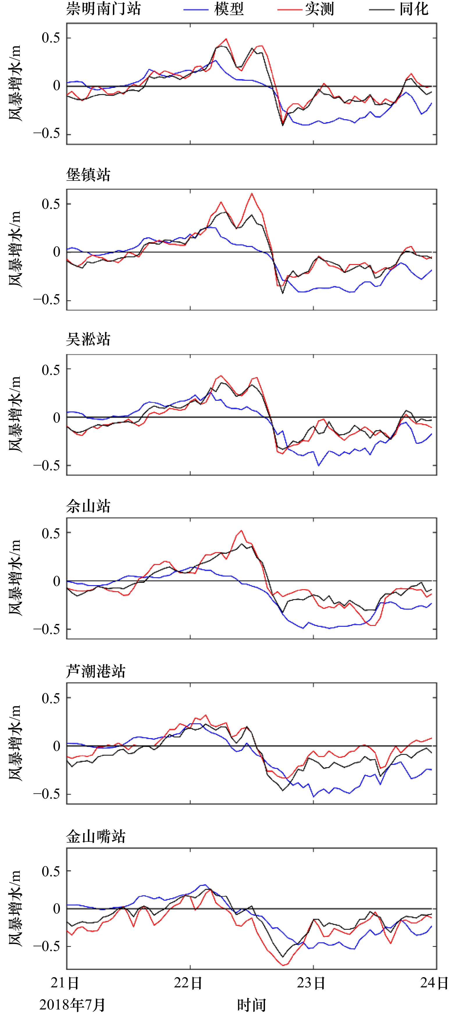
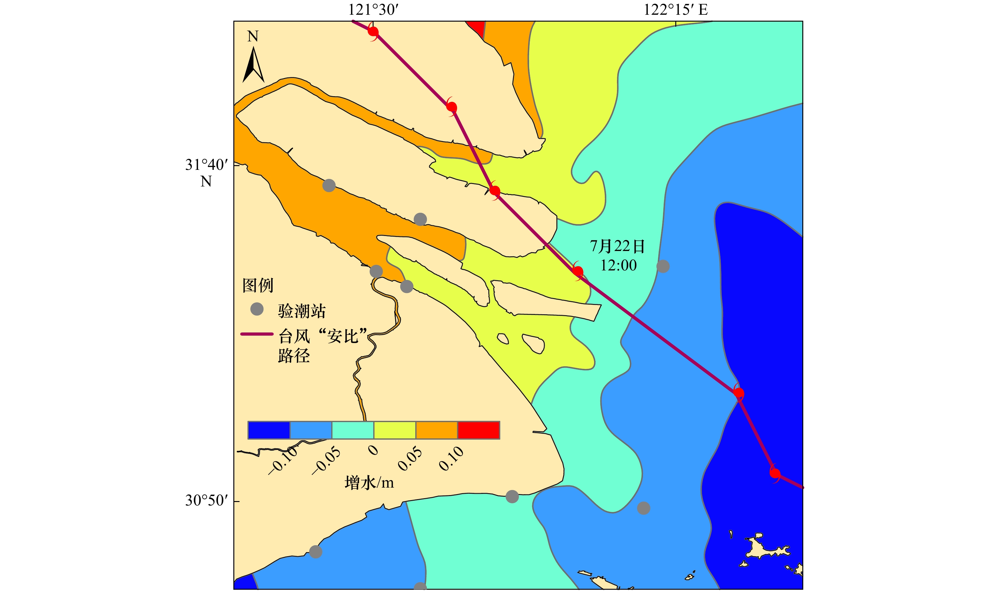
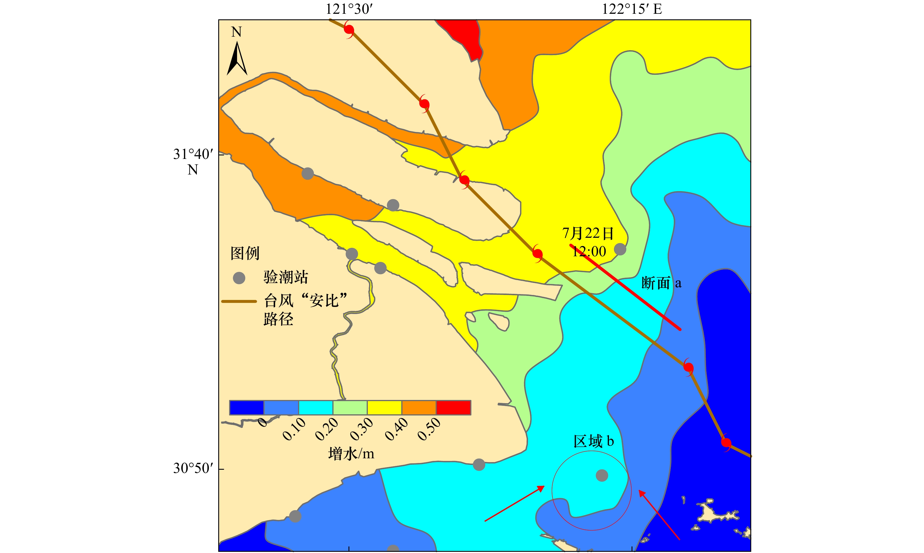
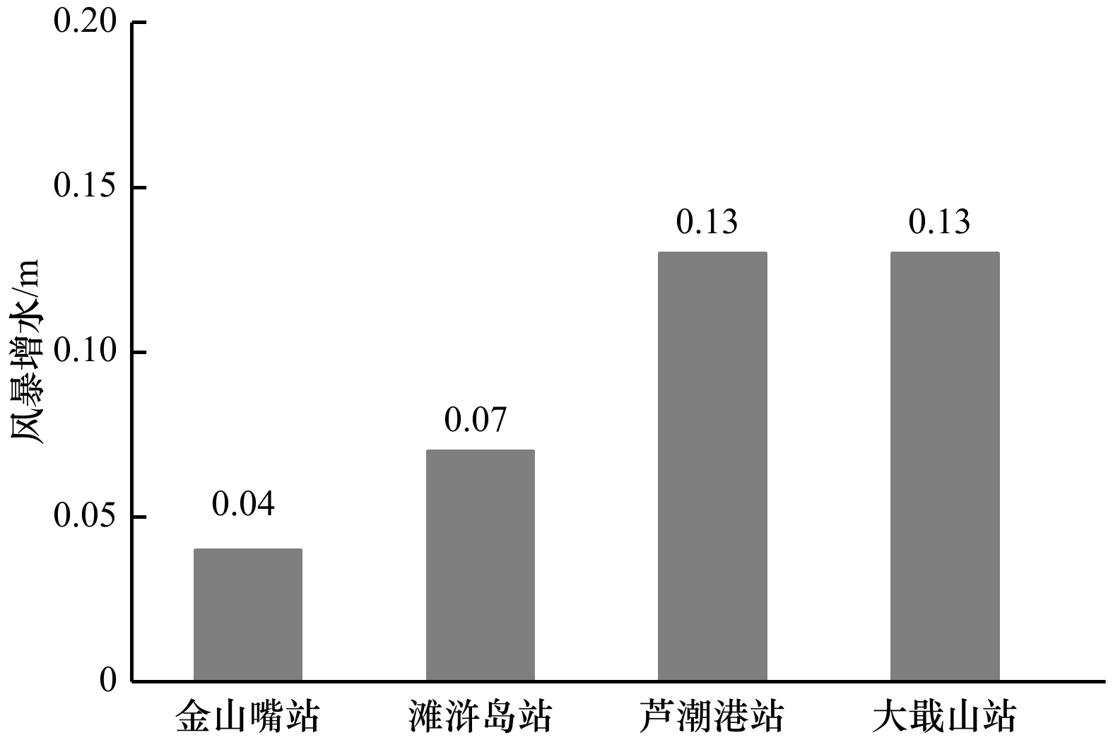
Storm surge is a complex ocean phenomenon which is sensitive to many factors and has attracted much attention. In this paper, based on covariance localization method of ensemble Kalman filter(EnKF), the storm surge data of different sources, different error and different spatial and temporal resolution calculated by tide gauge stations and FVCOM model were assimilated and fused for the first time. Taking the storm surge process of typhoon 201810 landing in Shanghai for example, the optimal solution of 72-hourly storm surge in the Shanghai offshore areas was obtained and verified, the setting range of set sample number and Schur radius were given. The results show that the root mean square error of storm surge calculated by the observed stations and the model is 0.20 m, while calculated by the observed stations and assimilation is 0.07 m, which is improved by 65%, the root mean square error calculated by independent observation and assimilation is 0.09 m, the ratio of set dispersion to root mean square error is 0.90, the assimilation effect is better and credible. The assimilated storm water increment field can clearly and accurately depict the characteristics of double peaks storm surge, typhone eye surge and frontal surge which can be better used for the research of storm surge, correction of numerical simulation and marine disaster prevention.
Storm surge is a complex ocean phenomenon which is sensitive to many factors and has attracted much attention. In this paper, based on covariance localization method of ensemble Kalman filter(EnKF), the storm surge data of different sources, different error and different spatial and temporal resolution calculated by tide gauge stations and FVCOM model were assimilated and fused for the first time. Taking the storm surge process of typhoon 201810 landing in Shanghai for example, the optimal solution of 72-hourly storm surge in the Shanghai offshore areas was obtained and verified, the setting range of set sample number and Schur radius were given. The results show that the root mean square error of storm surge calculated by the observed stations and the model is 0.20 m, while calculated by the observed stations and assimilation is 0.07 m, which is improved by 65%, the root mean square error calculated by independent observation and assimilation is 0.09 m, the ratio of set dispersion to root mean square error is 0.90, the assimilation effect is better and credible. The assimilated storm water increment field can clearly and accurately depict the characteristics of double peaks storm surge, typhone eye surge and frontal surge which can be better used for the research of storm surge, correction of numerical simulation and marine disaster prevention.


2021, 43(3): 146-156.
doi: 10.12284/hyxb2021027
Abstract:
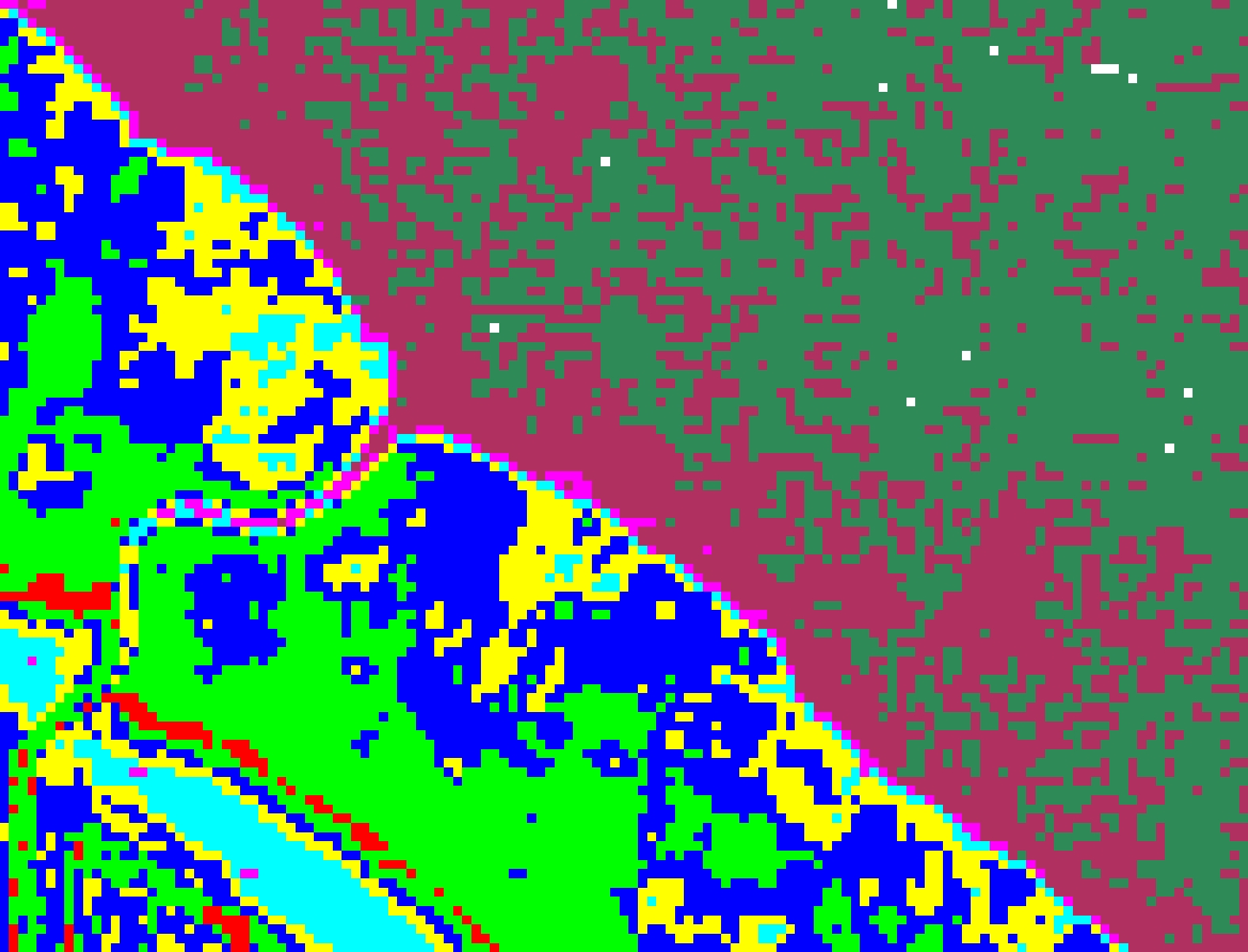
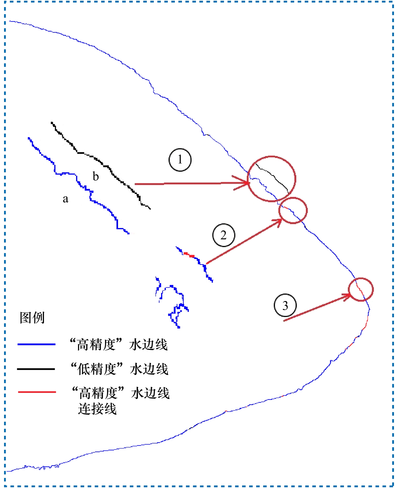
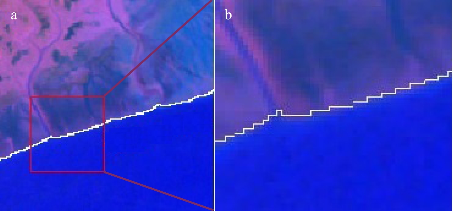
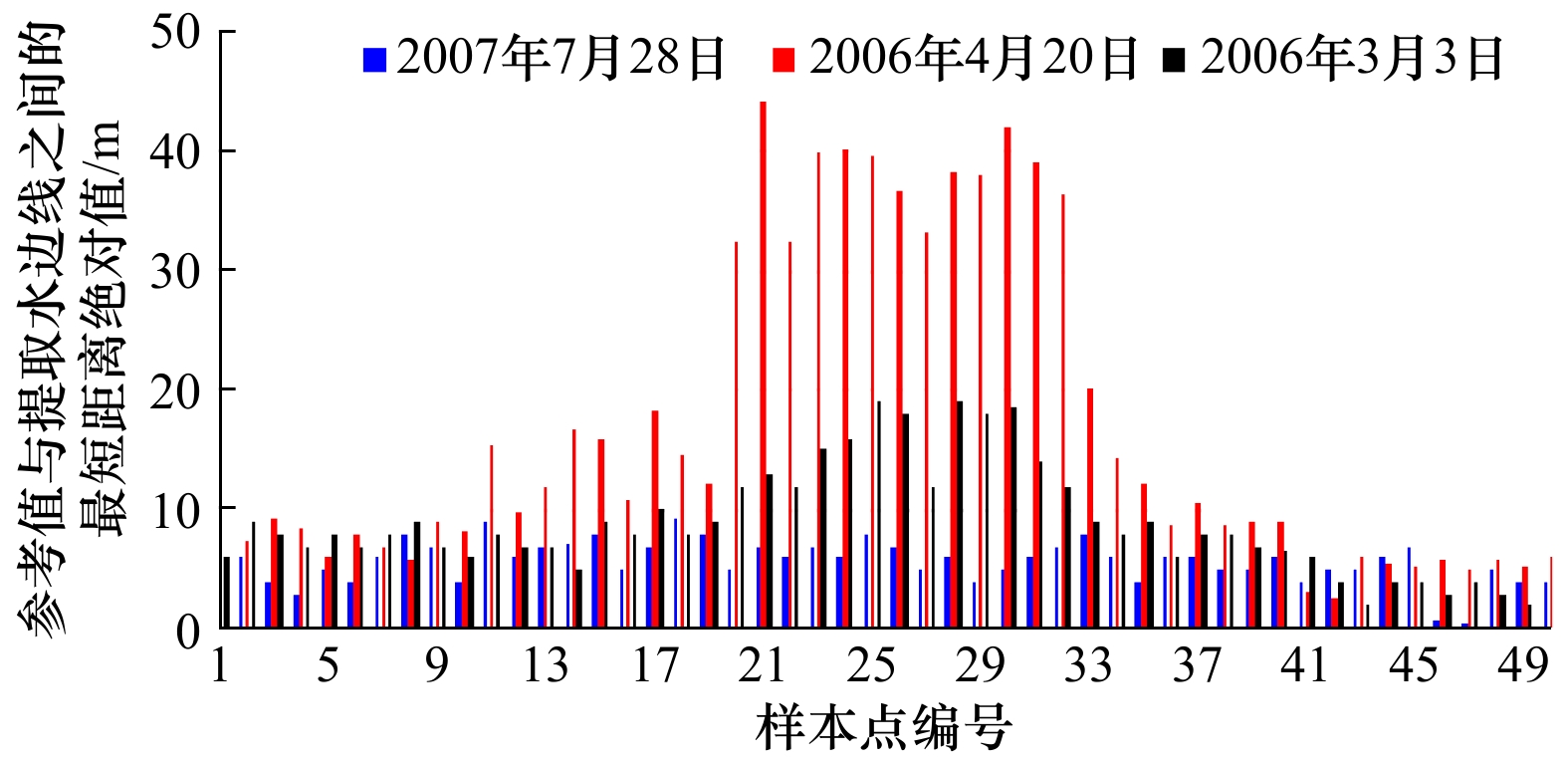
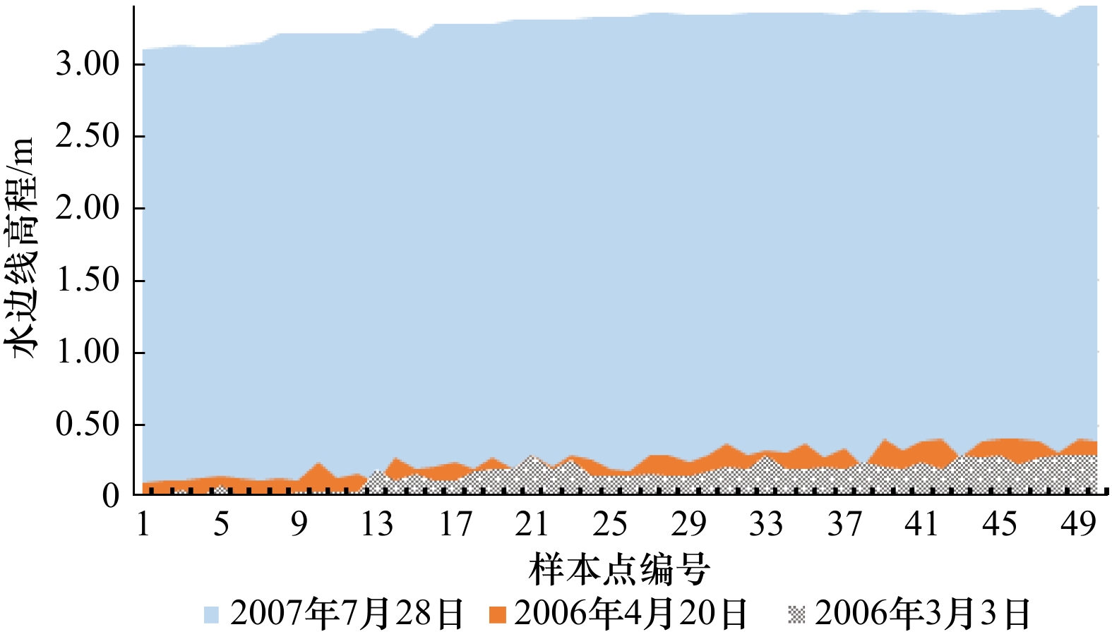
It is of great significance to quickly acquire spatiotemporal change in the information of waterline of remote sensing image. The extraction of the waterline of tidal flat on the remote sensing image has always been a difficult problem in the application of remote sensing technology. There are unique spatial relationships and spectral characteristics on the remote sensing image of waterline. The research area is the Chongming Dongtan of the Changjiang River Estuary. By integrating methods of color model transformation, information entropy calculation, maximum variance and edge detection, we explored how to enhance the contrast of land and sea on the Landsat-5 satellite image, and the edge extraction at different scales was studied. The calculation method of the spatial and spectral characteristics of the waterline using the thermal infrared band was given. A fast extraction method of waterline of sensory image taking the spatial relationship and spectral characteristics into account under the framework of object-oriented technology was proposed. Results show that: (1) The local threshold segmentation method based on the maximum between-class variance method can automatically extract the waterline of band 6. The waterline is continuous, complete, and rich in spatial information. (2) The combination of the optimum index factor method, the dispersion method and the color model transformation method can effectively enhance the contrast between land and sea. The local adaptive Canny operator based on the maximum between-class variance method can automatically detect the high precision edge of the enhanced remote sensing image. (3) Using the spatial relationship and spectral characteristic of waterline, the computer can recognize and connect waterline automatically. (4) The waterline extraction method proposed in this paper is fast and automated, inheriting strong continuity of the threshold segmentation method and high positioning accuracy and strong ability to present details of Canny operator. The results have significant value for researches on the dynamic changes in the coastal zone, the mechanism of land-sea interaction, the protection and development of coastal zone resources, and offshore engineering management.
It is of great significance to quickly acquire spatiotemporal change in the information of waterline of remote sensing image. The extraction of the waterline of tidal flat on the remote sensing image has always been a difficult problem in the application of remote sensing technology. There are unique spatial relationships and spectral characteristics on the remote sensing image of waterline. The research area is the Chongming Dongtan of the Changjiang River Estuary. By integrating methods of color model transformation, information entropy calculation, maximum variance and edge detection, we explored how to enhance the contrast of land and sea on the Landsat-5 satellite image, and the edge extraction at different scales was studied. The calculation method of the spatial and spectral characteristics of the waterline using the thermal infrared band was given. A fast extraction method of waterline of sensory image taking the spatial relationship and spectral characteristics into account under the framework of object-oriented technology was proposed. Results show that: (1) The local threshold segmentation method based on the maximum between-class variance method can automatically extract the waterline of band 6. The waterline is continuous, complete, and rich in spatial information. (2) The combination of the optimum index factor method, the dispersion method and the color model transformation method can effectively enhance the contrast between land and sea. The local adaptive Canny operator based on the maximum between-class variance method can automatically detect the high precision edge of the enhanced remote sensing image. (3) Using the spatial relationship and spectral characteristic of waterline, the computer can recognize and connect waterline automatically. (4) The waterline extraction method proposed in this paper is fast and automated, inheriting strong continuity of the threshold segmentation method and high positioning accuracy and strong ability to present details of Canny operator. The results have significant value for researches on the dynamic changes in the coastal zone, the mechanism of land-sea interaction, the protection and development of coastal zone resources, and offshore engineering management.


2021, 43(3): 157-164.
doi: 10.12284/hyxb2021043
Abstract:
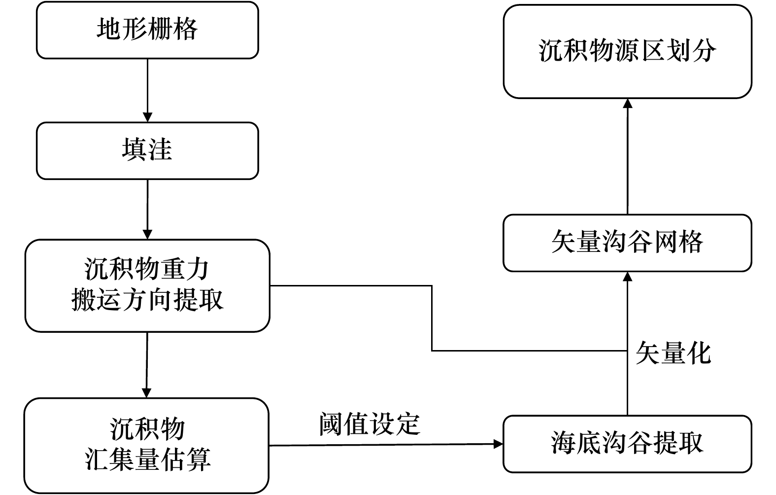
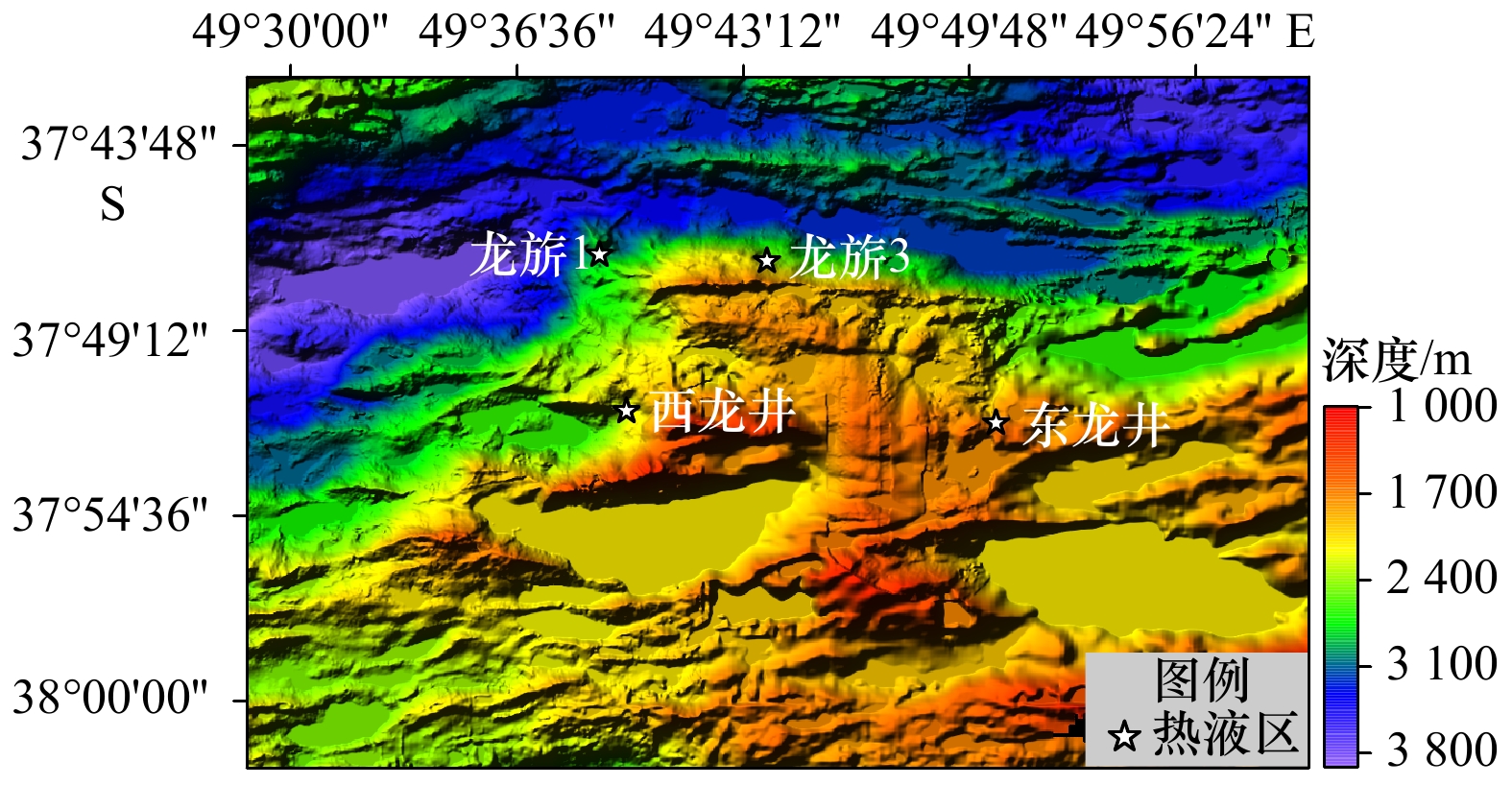
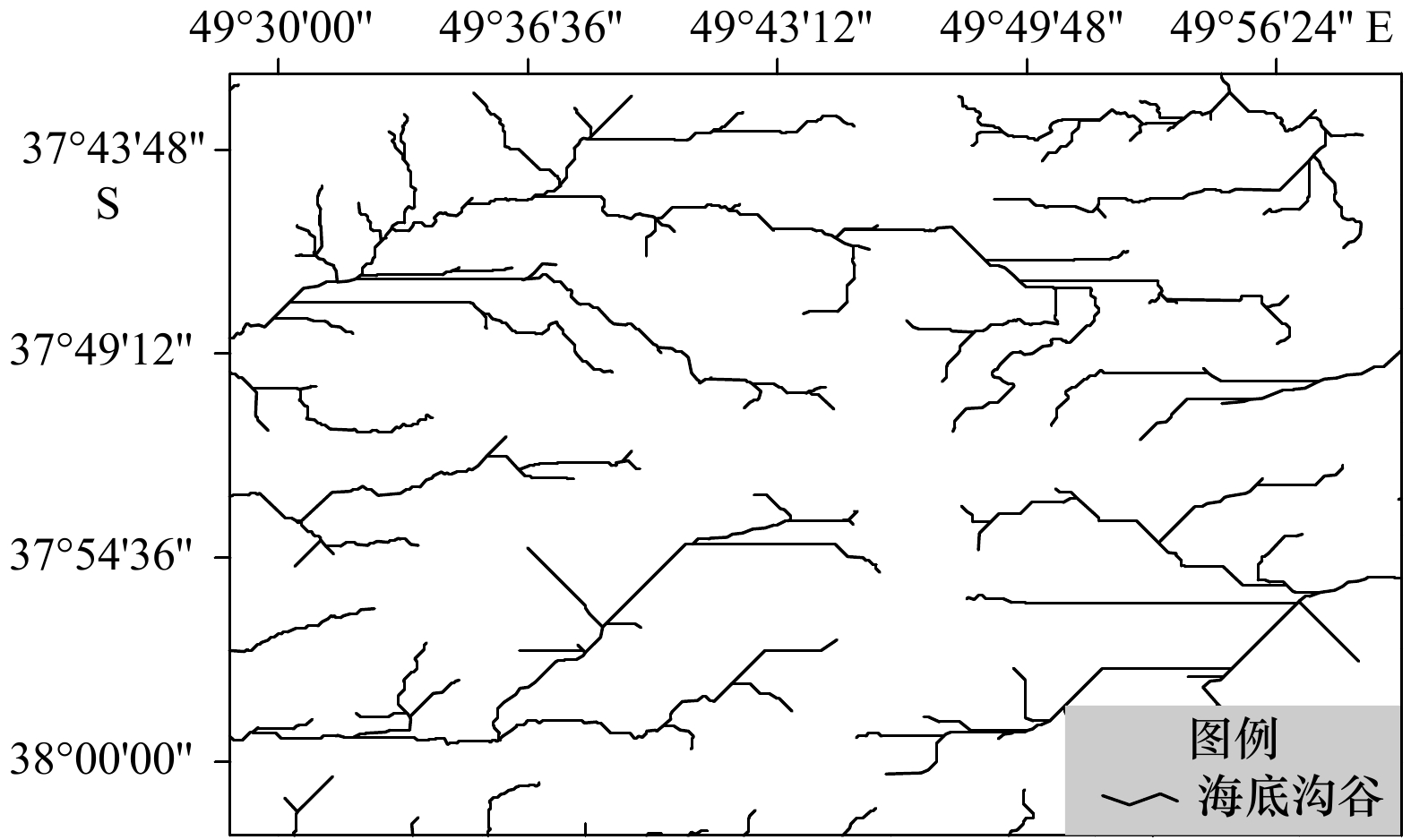
The sediments in the hydrothermal field received a large amount of hydrothermal input, and their mineral compositions and geochemical spatial distribution characteristics are effective indicators for polymetallic sulfide exploration. Due to gravity, sediments in the mid-ocean ridge area are mainly distributed in low-lying and flat terrain areas. In order to explore the influence of topographical factors on the distribution of sediments in the hydrothermal field, this paper proposes a prediction method of sediment distribution trend in seafloor hydrothermal field based on topography data through ArcGIS, and analyzes the topographic data of Dragon Horn area on the Southwest Indian Ridge, including the extraction gravity transport direction of sediment, the estimation of sediment accumulation amount, the extraction of submarine ditch valley and the division of sediment source area. By comparison and verification with the interpretation results of the seafloor camera data of the study area, we found that the prediction results are in good agreement with the actual distribution range of the sediments in the study area, indicating that this method can effectively indicate the distribution of sediments in the submarine hydrothermal field under the influence of terrain to a certain extent. This method has certain guiding significance for the exploration of submarine sulfide minerals, and could provides a reference basis for the setting of sampling stations for seafloor sediments and the delineation of polymetallic sulfide mineralization prospects.
The sediments in the hydrothermal field received a large amount of hydrothermal input, and their mineral compositions and geochemical spatial distribution characteristics are effective indicators for polymetallic sulfide exploration. Due to gravity, sediments in the mid-ocean ridge area are mainly distributed in low-lying and flat terrain areas. In order to explore the influence of topographical factors on the distribution of sediments in the hydrothermal field, this paper proposes a prediction method of sediment distribution trend in seafloor hydrothermal field based on topography data through ArcGIS, and analyzes the topographic data of Dragon Horn area on the Southwest Indian Ridge, including the extraction gravity transport direction of sediment, the estimation of sediment accumulation amount, the extraction of submarine ditch valley and the division of sediment source area. By comparison and verification with the interpretation results of the seafloor camera data of the study area, we found that the prediction results are in good agreement with the actual distribution range of the sediments in the study area, indicating that this method can effectively indicate the distribution of sediments in the submarine hydrothermal field under the influence of terrain to a certain extent. This method has certain guiding significance for the exploration of submarine sulfide minerals, and could provides a reference basis for the setting of sampling stations for seafloor sediments and the delineation of polymetallic sulfide mineralization prospects.


 Email alert
 RSS
RSS