

Remote sensing observation and numerical simulation of oceanic internal waves around the Bali Island: A preliminary study on the possible causes of an Indonesian submarine wreck
-
摘要: 基于巴厘岛北部海域海洋内波卫星遥感观测与数值模拟结果,本文对4·21印尼潜艇失踪事件原因进行了初步分析。结果表明,在印尼潜艇失事海域和时间,源于龙目海峡的海洋内波向北传播并广泛分布于巴厘岛北部海域,振幅可达50 m。潜艇很可能遭遇了大振幅海洋内波发生“掉深”而导致失事。Abstract: The possibility of the Indonesian submarine wreck on 20 April 2021 was analyzed based on satellite remote sensing observation and numerical simulation. The results indicate that large-amplitude oceanic internal waves, estimated to be approximately 50 m using satellite images, originate from the Lombok Strait. They are widely distributed to the north of the Bali Island and are suggested to cause an abrupt sinking of the Indonesian submarine.
-
Key words:
- north of Bali Island /
- oceanic internal wave /
- submarine wreck
-

图 1 巴厘岛海域获取的两景MODIS遥感影像,成像时间为2021年4月19日03:00 UTC(上)和4月21日02:50 UTC(下)。图中白色箭头指示观测到的内波波包。
Fig. 1 Two MODIS images acquired around the Bali Island at 03:00 UTC on April 19, 2021 (top) and at 02:50 UTC on April 21, 2021 (bottom), respectively. The white arrows mark the observed internal waves in the images
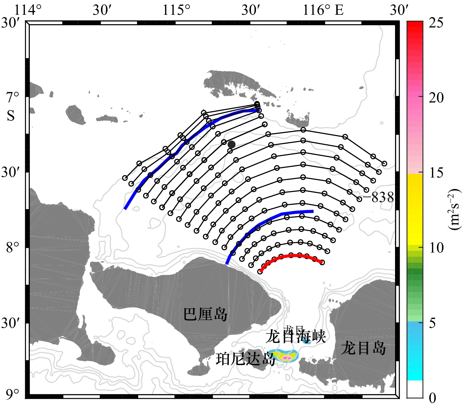
图 2 利用射线追踪法模拟的4月21日02:50−18:50 UTC时间段内龙目海峡海洋内波的传播过程。背景彩色为M2内潮体积产生力,蓝色实线为在4月19日03:00 UTC MODIS影像(图1上图)上观测到的内波条纹,红色实线为在4月21日02:50 UTC MODIS影像(图1下图)上观测到的内波先导波,黑色实线为模拟的间隔1小时的内波波峰线位置,黑色实心点标注的是潜艇被发现的位置。
Fig. 2 Propagation of the internal waves from the LOMBOK strait simulated by the ray tracing method. The background color indicates the distribution of the maximum depth-integrated body force for the M2 constituent. The blue and red lines represent the leading wave front observed from the MODIS image acquired on April 19, 2021 and April 21, respectively. The black lines represent the simulated wave fronts in one-hour time step. The black solid dot marks the location where the sunken submarine was discovered
-
[1] 范开国, 陈鹏, 顾艳镇, 等. 星载合成孔径雷达海洋遥感与图像解译[M]. 北京: 海洋出版社, 2017.Fan Kaiguo, Chen Peng, Gu Yanzhen, et al. SAR ocean remote sensing and image interpretation[M]. Beijing: Oceanic Press, 2017. [2] Jia Tong, Liang Jianjun, Li Xiaoming, et al. SAR observation and numerical simulation of internal solitary wave refraction and reconnection behind the Dongsha Atoll[J]. Journal of Geophysical Research: Oceans, 2018, 123(1): 74−89. doi: 10.1002/2017JC013389 [3] Liang Jiangjun, Li Xiaoming. Generation of second-mode internal solitary waves during winter in the northern South China Sea[J]. Ocean Dynamics, 2019, 69(3): 313−321. doi: 10.1007/s10236-019-01246-6 [4] Liang Jianjun, Li Xiaoming, Sha Jin, et al. The lifecycle of nonlinear internal waves in the northwestern South China Sea[J]. Journal of Physical Oceanography, 2019, 49(8): 2133−2145. doi: 10.1175/JPO-D-18-0231.1 [5] Jia Tong, Liang Jianjun, Li Xiaoming, et al. Retrieval of Internal Solitary Wave Amplitude in Shallow Water by Tandem Spaceborne SAR[J]. Remote Sensing, 2019, 11(14): 1706. doi: 10.3390/rs11141706 [6] Susanto R D, Mitnik L, Zheng Quanan. Ocean internal waves observed in the Lombok Strait[J]. Oceanography, 2005, 18(4): 80−87. doi: 10.5670/oceanog.2005.08 [7] Egbert G D, Erofeeva S Y. Efficient inverse modeling of barotropic ocean tides[J]. Journal of Atmospheric and Oceanic technology, 2002, 19(2): 183−204. doi: 10.1175/1520-0426(2002)019<0183:EIMOBO>2.0.CO;2 -

 下载:
下载:
计量
- 文章访问数: 1034
- HTML全文浏览量: 616
- PDF下载量: 181
- 被引次数: 0
