

The driving effect of human activities on the evolution of the Nanhui Shoal in the Yangtze River estuary
-
摘要: 两千年来长江口南岸基本呈“边滩推展”的演变趋势,基本以每40年约1 km的速度向海淤涨发育,是上海最重要的土地增长区和潮滩湿地资源,研究意义重大。本文基于1958~2019年南汇边滩冲淤特征、等深线变化及滩涂迁移速率等指标研究了南汇边滩近60年来的演变特征,通过时空对比探讨了其增长方式、驱动因素和发展趋势。结果表明:(1) 1958~2019年间南汇边滩呈“缓慢淤积−快速淤积−近淤远冲−全面侵蚀”四个阶段性变化,此阶段内最快淤涨和侵蚀速率分别为460 m/a和270 m/a。(2) 人类活动已经成为了影响长江口南汇边滩演变的主要控制因素,其中流域拦河筑坝、长江口分汊口控制工程、边滩围垦造陆、航道疏浚采砂等变化性因素极大的影响了南汇边滩的演变,其中边滩围垦造陆与地形演化的相关性较强,相关系数达0.73。(3) 随着国家和上海对围填海的严格管控,未来南汇边滩将逐步达到新的冲淤平衡,建议尽早研究河口潮滩湿地的保护和治理措施,以应对未来可能出现的岸带灾害。Abstract: For the past two thousand years, the southern bank of the Yangtze River estuary has basically shown an evolutionary trend of "Shoal extension", with a rate of about 1 km of siltation and development towards the sea every 40 years. It is the most important land growth area and tidal wetland resource in Shanghai, and the research significance is significant. This paper studies the evolution characteristics of Nanhui Shoal in the past 60 years based on indicators such as scouring and silting characteristics, isobath changes and mudflat migration rate from 1958 to 2019, and discusses its growth mode, driving factors and development trend through space-time comparison. The results showed that: (1) From 1958 to 2019, the Nanhuibian Shoal exhibited four stages of gradual siltation, rapid siltation, near siltation and far erosion, and comprehensive erosion. During this stage, the fastest siltation and erosion rates were 460 m/a and 270 m/a, respectively. (2) Human activities have become the main controlling factors affecting the evolution of the Nanhui Shoal at the mouth of the Yangtze River. Among them, variable factors such as watershed dam construction, Yangtze River estuary bifurcation control engineering, Shoal reclamation and land reclamation, and channel dredging and sand mining have greatly affected the evolution of the Nanhui Shoal. The correlation between Shoal reclamation and terrain evolution is strong, with a correlation coefficient of 0.73. (3) With the strict control of land reclamation by the government and Shanghai, the Nanhui Beach will gradually reach a new balance of erosion and deposition in the future. It is recommended to study the protection and management measures of estuarine tidal wetlands as soon as possible to cope with possible coastal disasters in the future.
-
Key words:
- Yangtze River estuary /
- Nanhui Shoal /
- human activity /
- siltation and swelling /
- erosion /
- engineering
-

图 1 长江河口整体格局和南汇边滩现状
a. 研究区位置;b. 长江口整体格局(2013年数据制作);c. 南汇边滩三维地貌(采用2013年数据)
Fig. 1 Overall pattern of the Yangtze River estuary and current status of the Nanhui Shoal
a. Location of the research area; b. The overall pattern of the Yangtze River estuary (2013 data); c. 3D Landform of Nanhui Shoal (2013 Data)

图 3 南汇边滩地形演变特征
a. 1958~1983;b. 1983~1997;c. 1997~2002;d. 2002~2007;e. 2007~2013;f. 2013~2019
Fig. 3 Topographic evolution characteristics of Nanhui Shoal
a. 1958~1983; b. 1983~1997; c. 1997~2002; d. 2002~2007; e. 2007~2013; f. 2013~2019

图 4 南汇边滩等深线变化
−2 m等深线变化:a. 1958~1997;b. 1997~2007;c. 2007~2019; −5 m等深线变化:d. 1958~1997;e. 1997~2007;f. 2007~2019
Fig. 4 Changes in the isobath of Nanhui Shoal
−2 m isobath variation: a. 1958~1997; b. 1997~2007; c. 2007~2019; −5 m isobath variation: d. 1958~1997; e. 1997~2007; f. 2007~2019
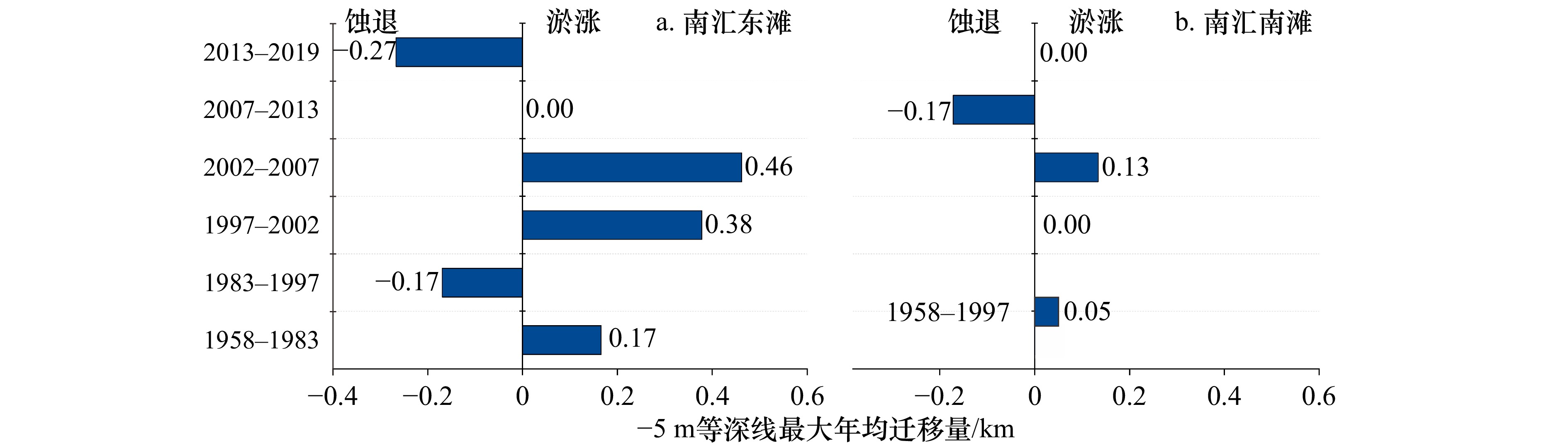
图 5 南汇边滩−5 m等深线迁移量
a. 南汇东滩1958~1997年−5 m等深线净迁移量;b. 南汇南滩1958~1997年−5 m等深线净迁移量,淤涨为正值,侵蚀为负值
Fig. 5 Migration of Nanhui Shoal −5 m isobath
a. Net migration of the −5 m isobath at Nanhui East Shoal from 1958 to 1997; b. Net migration of the −5 m isobath from 1958 to 1997, Siltation is positive, erosion is negative

图 6 流域输水输沙、河口圈围工程及分水分沙
a. 不同阶段长江流域输沙水沙变化及年均值;b. 南汇边滩地形冲淤厚度;c. 南汇边滩圈围面积;d. 输沙量和地形变化相关性分析;e. 圈围面积和地形变化相关性分析;f. 1998~2019年南槽分水分沙比;g. 2019年长江口三级分叉分水比
Fig. 6 Watershed water and sediment transport, estuary enclosure projects, and water and sediment separation
a. Changes in sediment transport and annual mean values in the Yangtze River Basin at different stages; b. The thickness of erosion and deposition in the terrain of Nanhui Shoal; c. Nanhui Shoal Circle Area; d. Correlation analysis between sediment transport volume and terrain changes; e. Correlation analysis between the area enclosed by the E-circle and terrain changes; f. Water and sand ratio in the southern trough from 1998 to 2019; g. The water splitting ratio of the third level bifurcation of the Yangtze River estuary in 2019
表 1 南汇边滩主要工程信息
Tab. 1 Engineering information of Nanhui Shoal
区域编号 工程名称 面积/
km2工程时间 工程信息 ① 人工半岛一期 7.3 1994~
1999促淤成陆 ② 浦东国际机场工程 10.0 1996~
1999促淤成陆 ③ 临港世纪塘 3.2 1998~
2000促淤成陆 ④ 南汇东滩促淤圈围一期 39.20 1999~
2000促淤成陆 ⑤ 南汇东滩促淤圈围二期 33.87 2000~
2001促淤成陆 ⑥ 人工半岛二期 33.00 2004~
2006促淤成陆 ⑦ 机场外侧圈围 15.67 2007~
2009促淤成陆 N1~N3;
S1~S3南汇东滩促淤整治一期 104.70 2013~
2014堤坝总长约67.40 km S4~S6 南汇东滩促淤整治二期 42.30 2016~
2017堤坝总长约19.10 km N1 N1库区消纳工程 14.67 2013~
2017促淤泥沙体积
约1933×104 m3 下载: 导出CSV
表 2 2007~2023年的水深测量信息
Tab. 2 Depth measurement information from 2007 to 2023
年份 每平方公里内测点密度 临近测点的间距/km 1958;1983;1997;2002;2007 3~8 2013;2019 20~31 1~1.5
下载: 导出CSV
表 3 基于海塘建设推算岸线迁移速率,部分数据统计于[8]
Tab. 3 Calculates the shoreline migration rate based on seawall construction, with some data collected in [8]
海塘名称 建设时间/年 海塘间距/km 间隔时间/年 迁移速度/(m/a) 古瀚海塘 713 里护塘 1172 16.00 459 34.86 钦公塘 1584 1.40 412 3.40 彭公塘 1884 7.20 300 24.00 人民塘 1960 3.14 76 41.32 胜利塘 1974 0.81 14 57.86 七九塘 1979 0.53 5 106.00 世纪塘 1994~2006 4.07 15~27 211.04 南汇东滩促淤
整治工程堤坝2013~2017 6.42 7~23 598.14
下载: 导出CSV
-
[1] 李九发, 戴志军, 应铭, 等. 上海市沿海滩涂土地资源圈围与潮滩发育演变分析[J]. 自然资源学报, 2007, 22(3): 361−371. doi: 10.3321/j.issn:1000-3037.2007.03.005Li Jiufa, Dai Zhijun, Ying Ming, et al. Analysis on the development and evolution of tidal flats and reclamation of land resource along shore of Shanghai City[J]. Journal of Natural Resources, 2007, 22(3): 361−371. doi: 10.3321/j.issn:1000-3037.2007.03.005 [2] Fan Daidu, Wu Yijing, Zhang Yue, et al. South flank of the Yangtze Delta: past, present, and future[J]. Marine Geology, 2017, 392: 78−93. doi: 10.1016/j.margeo.2017.08.015 [3] 陈吉余, 恽才兴, 徐海根, 等. 两千年来长江河口发育的模式[J]. 海洋学报, 1979, 1(1): 103−111.Chen Jiyu, Yun Caixing, Xu Haigen, et al. The developmental model of the Chang Jiang River estuary during last 2000 years[J]. Haiyang Xuebao, 1979, 1(1): 103−111. [4] 朱博渊, 刘凌峰, 李江夏, 等. 径流变化下长江口多分汊系统冲淤分布差异及动力机制[J]. 水科学进展, 2023, 34(4): 585−598.Zhu Boyuan, Liu Lingfeng, Li Jiangxia, et al. Erosion- deposition change pattern and hydrodynamic mechanism for the multilevel bifurcating system of Yangtze River Estuary under runoff variation[J]. Advances in Water Science, 2023, 34(4): 585−598. [5] Zhang Xiaodong, Fan Daidu, Yang Zuosheng, et al. Sustained growth of river-mouth bars in the vulnerable Changjiang Delta[J]. Journal of Hydrology, 2020, 590: 125450. doi: 10.1016/j.jhydrol.2020.125450 [6] Yang Z, Wang H, Saito Y, et al. Dam impacts on the Changjiang (Yangtze) river sediment discharge to the sea: the past 55 years and after the Three Gorges Dam[J]. Water Resources Research, 2006, 42(4): W04407. [7] 张晓东, 谢睿, 范代读, 等. 长江入海泥沙锐减下河口最大无人沙岛的持续淤涨[J]. 中国科学: 地球科学, 2021, 51(11): 1990−2000.Zhang Xiaodong, Xie Rui, Fan Daidu, et al. Sustained growth of the largest uninhabited alluvial island in the Changjiang Estuary under the drastic reduction of river discharged sediment[J]. Science China Earth Sciences, 2021, 64(10): 1687−1697. [8] 茅志昌, 虞志英, 徐海根. 上海潮滩研究[M]. 上海: 华东师范大学出版社, 2014.Mao Zhichang, Yu Zhiying, Xu Haigen. Shanghai Tidal Shoal Research[M]. Shanghai: East China Normal University Press, 2014. (查阅网上资料, 未找到本条文献英文信息, 请确认) [9] Yang S L, Milliman J D, Li P, et al. 50, 000 dams later: erosion of the Yangtze River and its delta[J]. Global and Planetary Change, 2011, 75(1/2): 14−20. [10] Yang H F, Yang S L, Xu K H, et al. Human impacts on sediment in the Yangtze River: a review and new perspectives[J]. Global and Planetary Change, 2018, 162: 8−17. doi: 10.1016/j.gloplacha.2018.01.001 [11] Dai Zhijun, Liu J T, Wei Wen, et al. Detection of the Three Gorges Dam influence on the Changjiang (Yangtze River) submerged delta[J]. Scientific Reports, 2014, 4: 6600. doi: 10.1038/srep06600 [12] Wu Ziyin, Zhao Dineng, Syvitski J P M, et al. Anthropogenic impacts on the decreasing sediment loads of nine major rivers in China, 1954–2015[J]. Science of The Total Environment, 2020, 739: 139653. doi: 10.1016/j.scitotenv.2020.139653 [13] Yang S L, Belkin I M, Belkina A I, et al. Delta response to decline in sediment supply from the Yangtze River: evidence of the recent four decades and expectations for the next half-century[J]. Estuarine, Coastal and Shelf Science, 2003, 57(4): 689−699. doi: 10.1016/S0272-7714(02)00409-2 [14] Gao Shu, Wang Yaping, Gao Jianhua. Sediment retention at the Changjiang sub-aqueous delta over a 57 year period, in response to catchment changes[J]. Estuarine, Coastal and Shelf Science, 2011, 95(1): 29−38. doi: 10.1016/j.ecss.2011.07.015 [15] Syvitski J P M, Kettner A J, Overeem I, et al. Sinking deltas due to human activities[J]. Nature Geoscience, 2009, 2(10): 681−686. doi: 10.1038/ngeo629 [16] Tessler Z D, Vörösmarty C J, Grossberg M, et al. Profiling risk and sustainability in coastal deltas of the world[J]. Science, 2015, 349(6248): 638−643. doi: 10.1126/science.aab3574 [17] Guo Xingjie, Fan Daidu, Zheng Shuwei, et al. Revisited sediment budget with latest bathymetric data in the highly altered Yangtze (Changjiang) Estuary[J]. Geomorphology, 2021, 391: 107873. doi: 10.1016/j.geomorph.2021.107873 [18] 陈沈良, 张国安, 谷国传. 长江口南汇边滩的演变及其沉积动力机制[J]. 上海地质, 2003(4): 1−4.Chen Shenliang, Zhang Guoan, Gu Guochuan. Geomorphic evolution of Nanhui nearshore of the Yangtze estuary and its sediment dynamic mechanism[J]. Shanghai Geology, 2003(4): 1−4. [19] 曹涌, 张永昌, 吴湘宾. 上海市滩涂资源及其开发利用[J]. 农业区划, 1988(2): 14−18.Cao Yong, Zhang Yongchang, Wu Xiangbin. Mudflat resources and their development and utilization in Shanghai[J]. Chinese Journal of Agricultural Resources and Regional Planning, 1988(2): 14−18. [20] 茅志昌, 李九发, 吴华林. 上海市滩涂促淤圈围研究[J]. 泥沙研究, 2003(2): 77−81. doi: 10.3321/j.issn:0468-155X.2003.02.014Mao Zhichang, Li Jiufa, Wu Hualin. Study on siltation and reclamation of tidal flat in Shanghai[J]. Journal of Sediment Research, 2003(2): 77−81. doi: 10.3321/j.issn:0468-155X.2003.02.014 [21] 施玉麒, 王寒梅, 李金柱. 上海市海岸带资源现状与未来趋势[J]. 上海地质, 2003(1): 8−16.Shi Yuqi, Wang Hanmei, Li Jinzhu. The actuality and trend for the coastal belt's resource of Shanghai[J]. Shanghai Geology, 2003(1): 8−16. [22] 赵建春, 李九发, 李占海, 等. 长江口南汇嘴潮滩短期冲淤演变及其动力机制研究[J]. 海洋学报, 2009, 31(4): 103−111. doi: 10.3321/j.issn:0253-4193.2009.04.012Zhao Jianchun, Li Jiufa, Li Zhanhai, et al. Researches on characteristics and dynamic mechanism of short-term scouring and silting changes of the tidal flat on Nanhui Spit in the Changjiang Estuary in China[J]. Haiyang Xuebao, 2009, 31(4): 103−111. doi: 10.3321/j.issn:0253-4193.2009.04.012 [23] 李九发, 戴志军, 刘新成, 等. 长江河口南汇嘴潮滩圈围工程前后水沙运动和冲淤演变研究[J]. 泥沙研究, 2010(3): 31−37.Li Jiufa, Dai Zhijun, Liu Xincheng, et al. Research on the movement of water and suspended sediment and sedimentation in Nanhui spit of the Yangtze Estuary before and after the construction of reclamation projects on the tidal flat[J]. Journal of Sediment Research, 2010(3): 31−37. [24] 刘曙光, 郁微微, 匡翠萍, 等. 三峡工程对长江口南汇边滩近期演变影响初步预测[J]. 同济大学学报(自然科学版), 2010, 38(5): 679−684. doi: 10.3969/j.issn.0253-374x.2010.05.009Liu Shuguang, Yu Weiwei, Kuang Cuiping, et al. Preliminary prediction on recent topography evolution of Nanhui tidal flat in Yangtze estuary due to Three Gorges project[J]. Journal of Tongji University (Natural Science), 2010, 38(5): 679−684. doi: 10.3969/j.issn.0253-374x.2010.05.009 [25] 恽才兴. 从水沙条件及河床地形变化规律谈长江河口综合治理开发战略问题[J]. 海洋地质动态, 2004, 20(7): 8−14. doi: 10.3969/j.issn.1009-2722.2004.07.003Yun Caixing. Comprehensive control and development strategy on the basis of the changes in water and silt conditions and riverbed topographic features[J]. Marine Geology Letters, 2004, 20(7): 8−14. doi: 10.3969/j.issn.1009-2722.2004.07.003 [26] 戴志军, 陈吉余, 程和琴, 等. 南汇边滩的沉积特征和沉积物输运趋势[J]. 长江流域资源与环境, 2005, 14(6): 735−739. doi: 10.3969/j.issn.1004-8227.2005.06.013Dai Zhijun, Chen Jiyu, Cheng Heqin, et al. Sediment characteristics and transport patterns in Nanhui joint area[J]. Resources and Environment in the Yangtze Basin, 2005, 14(6): 735−739. doi: 10.3969/j.issn.1004-8227.2005.06.013 [27] 计娜, 程和琴, 杨忠勇, 等. 近30年来长江口岸滩沉积物与地貌演变特征[J]. 地理学报, 2013, 68(7): 945−954.Ji Na, Cheng Heqin, Yang Zhongyong, et al. Sedimentary and morphological evolution of nearshore coast of Yangtze Estuary in the last 30 years[J]. Acta Geographica Sinica, 2013, 68(7): 945−954. [28] Luan Hualong, Ding Pingxing, Wang Zhengbing. Morphodynamic impacts of large-scale engineering projects in the Yangtze River delta[J]. Coastal Engineering, 2018, 141: 1−11. doi: 10.1016/j.coastaleng.2018.08.013 [29] Wang Houjie, Saito Y, Zhang Yong, et al. Recent changes of sediment flux to the western Pacific Ocean from major rivers in East and Southeast Asia[J]. Earth-Science Reviews, 2011, 108(1/2): 80−100. [30] Wheaton J M, Brasington J, Darby S E, et al. Accounting for uncertainty in DEMs from repeat topographic surveys: improved sediment budgets[J]. Earth Surface Processes and Landforms, 2010, 35(2): 136−156. doi: 10.1002/esp.1886 [31] 马彬彬, 何钰滢, 戴志军. 流域和河口高强度人类活动对崇明岛滩涂资源变化过程的影响[J]. 自然资源学报, 2022, 37(4): 1025−1035. doi: 10.31497/zrzyxb.20220413Ma Binbin, He Yuying, Dai Zhijun. Study on the influence of intensive human activities on the variation process of tidal flat resources in Chongming Island[J]. Journal of Natural Resources, 2022, 37(4): 1025−1035. doi: 10.31497/zrzyxb.20220413 [32] 陈吉余, 程和琴, 戴志军. 河口过程中第三驱动力的作用和响应——以长江河口为例[J]. 自然科学进展, 2008, 18(9): 994−1000.Chen Jiyu, Cheng Heqin, Dai Zhijun. The role and response of the third driving force in estuarine processes - taking the Yangtze River estuary as an example[J]. Progress in Natural Science, 2008, 18(9): 994−1000. (查阅网上资料, 未找到本条文献英文信息, 请确认) [33] Dai Zhijun, Liu J T, Fu Gui, et al. A thirteen-year record of bathymetric changes in the North Passage, Changjiang (Yangtze) estuary[J]. Geomorphology, 2013, 187: 101−107. doi: 10.1016/j.geomorph.2013.01.004 [34] 张迪祥. 春秋、战国时期以来长江流域人口活动对植被变迁的影响[J]. 植物资源与环境学报, 2000, 9(1): 47−53. doi: 10.3969/j.issn.1674-7895.2000.01.012Zhang Dixiang. The effect of population activity on the changes in vegetation of Yangtze River Valley since the ancient period of Spring and Autumn-Warring States (770~221 B. C. )[J]. Journal of Plant Resources and Environment, 2000, 9(1): 47−53. doi: 10.3969/j.issn.1674-7895.2000.01.012 [35] 郑树伟, 程和琴, 石盛玉, 等. 长江大通至徐六泾水下地形演变的人为驱动效应[J]. 中国科学: 地球科学, 2018, 48(5): 628−638.Zheng Shuwei, Cheng Heqin, Shi Shengyu, et al. Impact of anthropogenic drivers on subaqueous topographical change in the Datong to Xuliujing reach of the Yangtze River[J]. Science China Earth Sciences, 2018, 61(7): 940−950. [36] Dai Zhijun, Mei Xuefei, Darby S E, et al. Fluvial sediment transfer in the Changjiang (Yangtze) river-estuary depositional system[J]. Journal of Hydrology, 2018, 566: 719−734. doi: 10.1016/j.jhydrol.2018.09.019 [37] Zhang Xiaodong, Fan Daidu, Yang Zuosheng, et al. Sustained growth of river-mouth bars in the vulnerable Changjiang Delta[J]. Journal of Hydrology, 2020, 590: 125450. (查阅网上资料, 本条文献与第条文献重复, 请确认) [38] 黎兵, 严学新, 何中发, 等. 长江口水下地形演变对三峡水库蓄水的响应[J]. 科学通报, 2015, 60(18): 1735−1744. doi: 10.1360/N972014-01074Li Bing, Yan Xuexin, He Zhongfa, et al. Impacts of the Three Gorges Dam on the bathymetric evolution of the Yangtze River Estuary[J]. Chinese Science Bulletin, 2015, 60(18): 1735−1744. doi: 10.1360/N972014-01074 [39] 刘杰, 程海峰, 韩露, 等. 流域减沙对长江口典型河槽及邻近海域演变的影响[J]. 水科学进展, 2017, 28(2): 249−256.Liu Jie, Cheng Haifeng, Han Lu, et al. Influence of fluvial sediment decline on the morphdynamics of the Yangtze River Estuary and adjacent seas[J]. Advances in Water Science, 2017, 28(2): 249−256. [40] Zhou Zaiyang, Ge Jianzhong, Wang Zhengbing, et al. Study of lateral flow in a stratified tidal channel-shoal system: the importance of intratidal salinity variation[J]. Journal of Geophysical Research: Oceans, 2019, 124(9): 6702−6719. doi: 10.1029/2019JC015307 [41] 郭兴杰, 王寒梅, 史玉金, 等. 近期长江口南槽河道滩槽冲刷及驱动因素分析[J]. 应用基础与工程科学学报, 2021, 29(4): 785−796.Guo Xingjie, Wang Hanmei, Shi Yujin, et al. Analysis of the bottom evolution and the driven mechanisms in the south passage of Yangtze estuary over the recent years[J]. Journal of Basic Science and Engineering, 2021, 29(4): 785−796. [42] 程海峰, 刘杰, 陈复奎, 等. 长江口航道疏浚土“十四五”综合利用研究[J]. 长江流域资源与环境, 2023, 32(2): 331−338.Cheng Haifeng, Liu Jie, Chen Fukui, et al. Study on comprehensive utilization of dredged soil in Yangtze estuary channel during the 14th Five-year Period[J]. Resources and Environment in the Yangtze Basin, 2023, 32(2): 331−338. -


计量
- 文章访问数: 37
- HTML全文浏览量: 10
- PDF下载量: 12
- 被引次数: 0
