

Study on the relationship between tidal creeks divergence, vegetation and topography based on UAV remote sensing
-
摘要: 潮沟作为陆海之间的重要物质、能量、信息交换通道,其发育情况将决定潮滩上植被群落生长和演替的方向,同时植被的生长也将影响潮沟的发育和地形的演变。为了研究江苏盐城滨海湿地潮滩植被类型分布和其对潮沟发育的影响,在无人机技术支持下,通过反演潮滩地形高程模型和提取植被信息,对条子泥南部潮滩进行了观测。结果表明:(1)随着互花米草群落的扩张,潮滩原有盐沼植被群落出现了斑块萎缩的现象;(2)随着潮沟向内陆延伸,其沟底逐渐被互花米草占据,互花米草呈现明显的沿潮沟分布;(3)潮沟两侧有沿岸堤出现,互花米草对潮沟及附近滩面的地形有抬升的作用。由此可以看出,潮沟的发育将加速互花米草的入侵,且其入侵可改变潮滩原有地形和植被类型组成。这有利于进一步认识潮沟在潮滩上发育时是如何影响植被种群分布状况,并展现了植被分布对于潮沟发育的反作用,为当地互花米草的治理和无人机技术在其中的运用提供一定参考意见。Abstract: As an important material, energy and information exchange channel between land and sea, the development of the tidal creek would determine the vegetation growth and succession on the tidal flats. The growth of vegetation would also influence the evolution of the tidal creek and the topography. The aim of this study was to investigate the distribution of tidal flats vegetation types in the Yancheng coastal wetland, Jiangsu Province and their influence on tidal creek development. Through the UAV technology, the inversion of the tidal flats topographic elevation model and the extraction of vegetation information, it observed the tidal flats of southern Tiaozini. The results showed that: (1) with the expansion of the cordgrass (Spartina alterniflora) community, the original salt marsh vegetation on the tidal flats appeared to shrink in patches; (2) as the tidal channel extended inland, the bottom of the channel was gradually occupied by cordgrass which showed an obvious distribution along the tidal creeks; (3) there were littoral ridges on both sides of the tidal creek, and cordgrass has the effect to uplift the terrain of the topography of tidal creeks and the tidal flat nearby. The development of tidal creeks would accelerate the invasion of cordgrass, and its invasion can change the original topography and vegetation compositions of the tidal flats. This contributed to the understanding of how tidal creeks affected the distribution of vegetation populations as they developed on the tidal flats. It demonstrated the inverse effect of vegetation distribution on the tidal creek development. The study could provide some reference for the local management of cordgrass and the use of drone technology in it.
-
Key words:
- tidal flats vegetation /
- coastal wetlands /
- unmanned aerial vehicle /
- topography /
- tidal creek
-

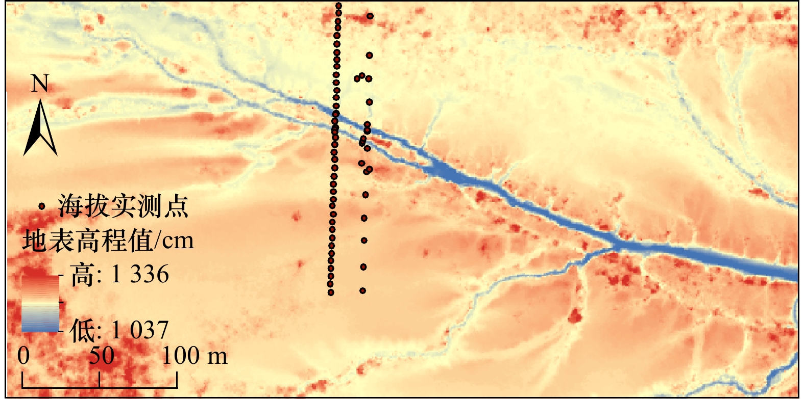
图 4 DEM模型反演高程与RTK测量结果比较
Fig. 4 Comparison between elevation of DEM model inversion and RTK measurements
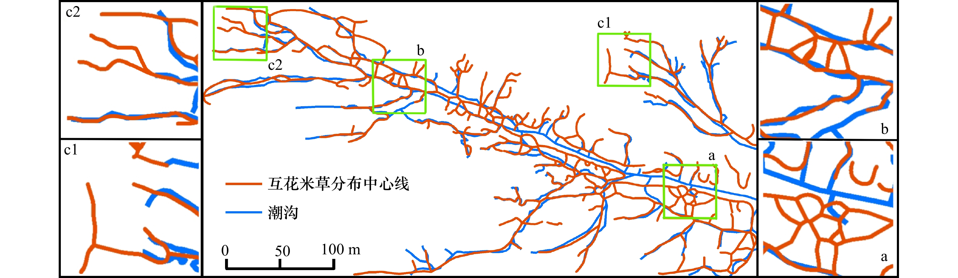
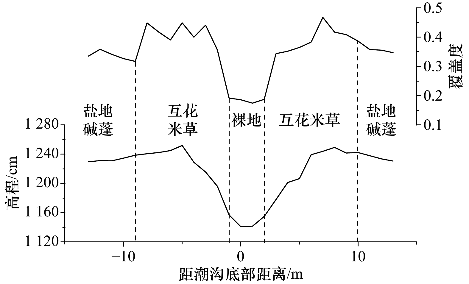
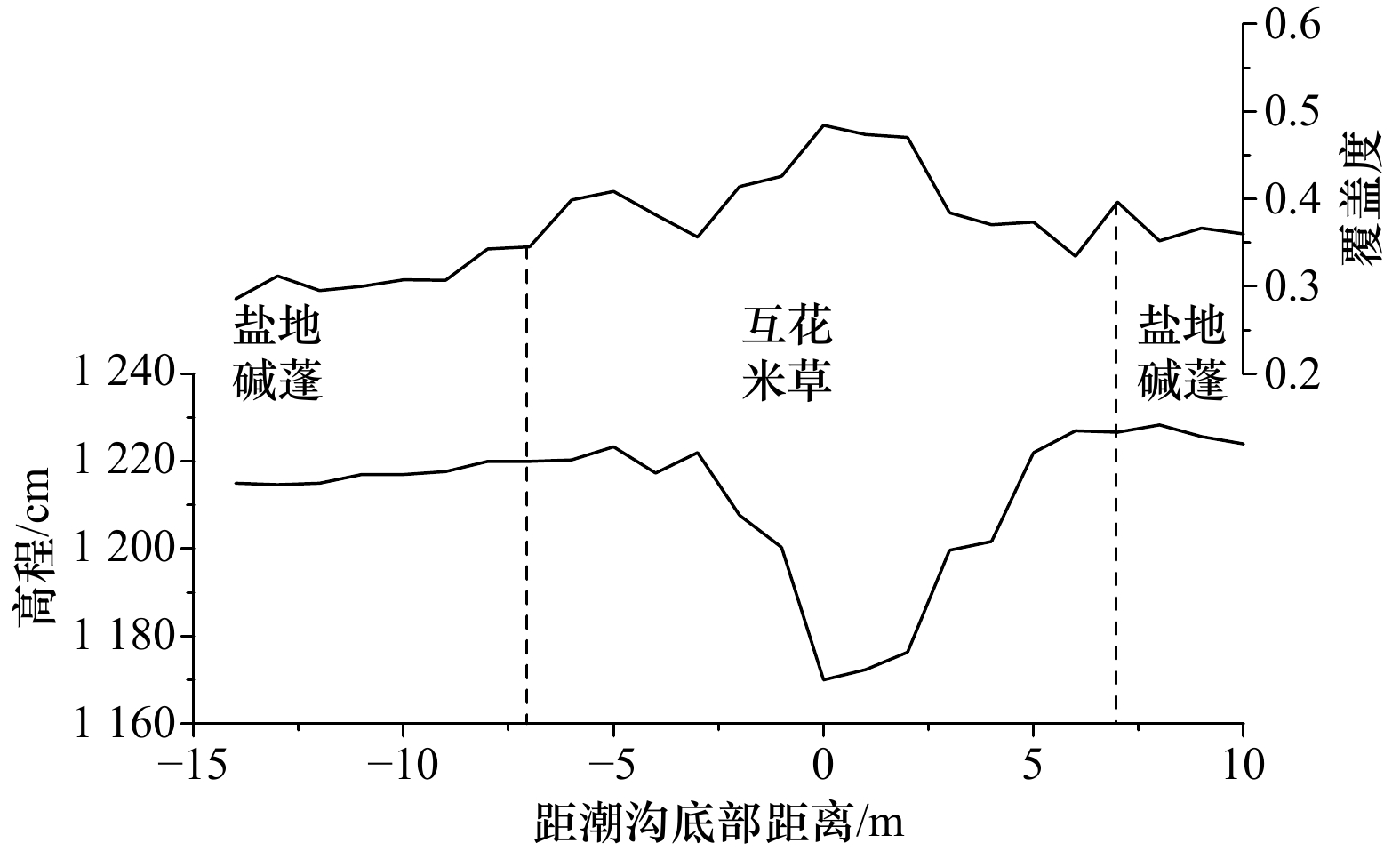
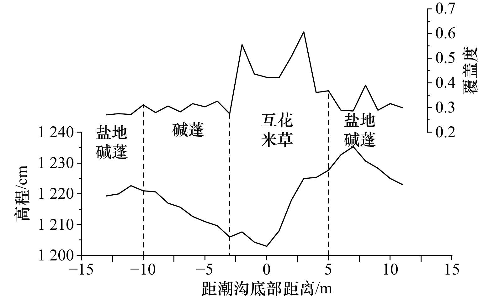
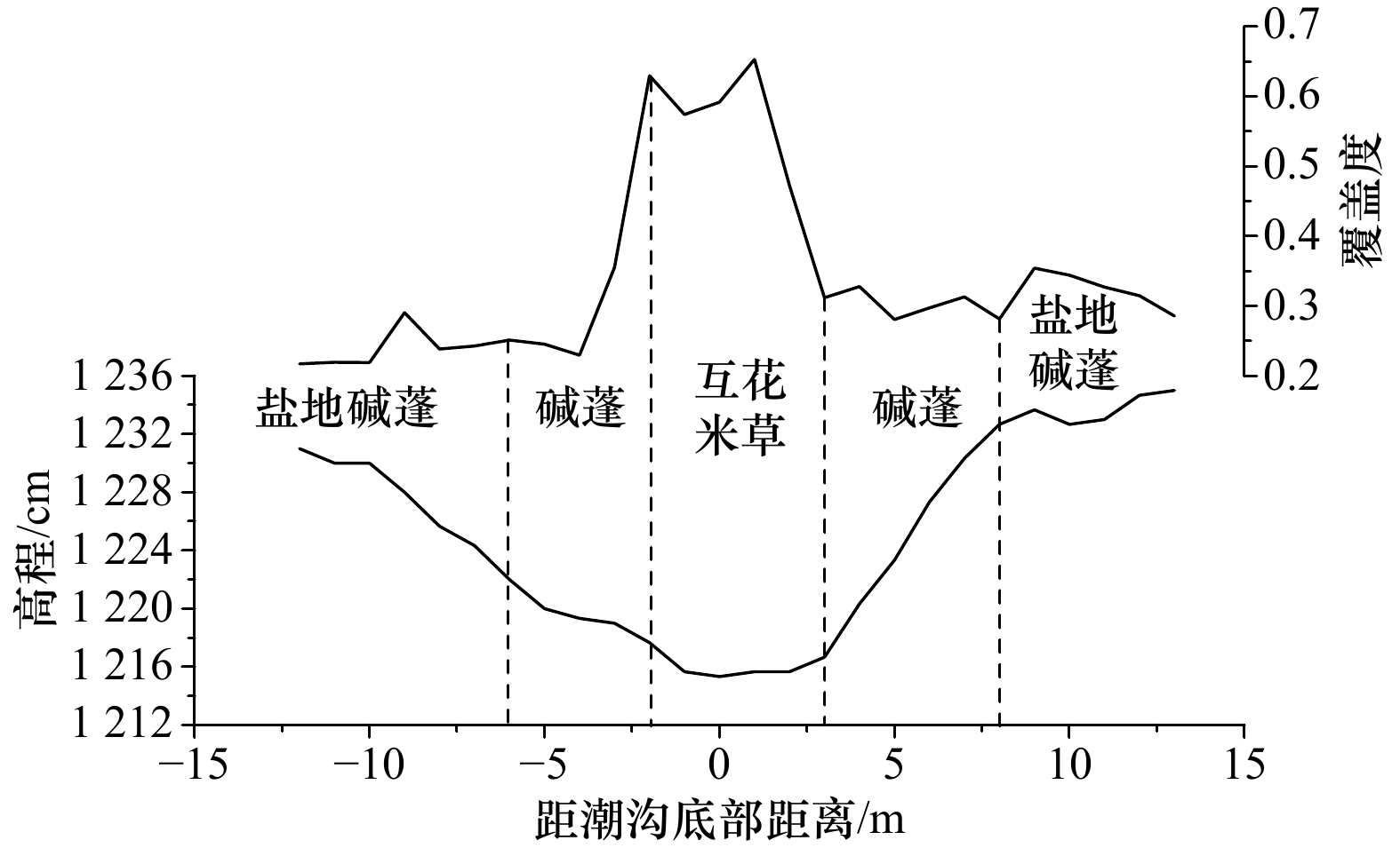
图 9 互花米草分布中心线与潮沟位置对比
Fig. 9 The centreline of the spartina alterniflora distribution compared to the location of the tidal ditch

图 16 2013−2021年研究区环境变化
a、b、c、d分别为研究区所在位置2013年、2015年、2018年和2021年的卫星影像图,蓝线为潮沟位置示意,可看出植被逐年沿潮沟在研究区内潮滩上扩散且潮沟正逐渐消退
Fig. 16 Environmental changes in the study area between 2013 and 2021
a, b, c and d are satellite images of the location of the study area in 2013, 2015, 2018 and 2021 respectively, the blue line shows the location of the tidal creek; it shows that vegetation is spreading along the tidal creek on the tidal flats in the study area year by year and that the tidal creek is gradually receding
-
[1] 张濛, 濮励杰. 近30年来江苏省滨海湿地变化过程及其受围垦活动的影响[J]. 湿地科学与管理, 2017, 13(3): 56−60. doi: 10.3969/j.issn.1673-3290.2017.03.11Zhang Meng, Pu Lijie. The changing process of coastal wetlands and the effects of reclamation in Jiangsu Province in recent 30 years[J]. Wetland Science & Management, 2017, 13(3): 56−60. doi: 10.3969/j.issn.1673-3290.2017.03.11 [2] Duarte C M, Losada I J, Hendriks I E, et al. The role of coastal plant communities for climate change mitigation and adaptation[J]. Nature Climate Change, 2013, 3(11): 961−968. doi: 10.1038/nclimate1970 [3] Kirwan M L, Megonigal J P. Tidal wetland stability in the face of human impacts and sea-level rise[J]. Nature, 2013, 504(7478): 53−60. doi: 10.1038/nature12856 [4] 李阳, 袁琳, 赵志远, 等. 基于无人机低空遥感和现场调查的潮滩地形反演研究[J]. 自然资源遥感, 2021, 33(3): 80−88.Li Yang, Yuan Lin, Zhao Zhiyuan, et al. Inversion of tidal flat topography based on unmanned aerial vehicle low-altitude remote sensing and field surveys[J]. Remote Sensing for Natural Resources, 2021, 33(3): 80−88. [5] 赵欣胜, 崔保山, 孙涛, 等. 黄河三角洲潮沟湿地植被空间分布对土壤环境的响应[J]. 生态环境学报, 2010, 19(8): 1855−1861. doi: 10.3969/j.issn.1674-5906.2010.08.015Zhao Xinsheng, Cui Baoshan, Sun Tao, et al. The relationship between the spatial distribution of vegetation and soil environmental factors in the tidal creek areas of the Yellow River Delta[J]. Ecology and Environment Sciences, 2010, 19(8): 1855−1861. doi: 10.3969/j.issn.1674-5906.2010.08.015 [6] 赖婷, 杨为民, 田波. 遥感与GIS支持下杭州湾北岸湿地空间威胁性分析与评价研究[J]. 复旦学报(自然科学版), 2013, 52(3): 356−362. doi: 10.15943/j.cnki.fdxb-jns.2013.03.012Lai Ting, Yang Weimin, Tian Bo. A GIS and remote sensing based analysis of wetland spatial threat in the North Hangzhou Bay[J]. Journal of Fudan University (Natural Science), 2013, 52(3): 356−362. doi: 10.15943/j.cnki.fdxb-jns.2013.03.012 [7] 黄华梅, 张利权, 袁琳. 崇明东滩自然保护区盐沼植被的时空动态[J]. 生态学报, 2007, 27(10): 4166−4172. doi: 10.3321/j.issn:1000-0933.2007.10.025Huang Huamei, Zhang Liquan, Yuan Lin. The spatio-temporal dynamics of salt marsh vegetation for Chongming Dongtan National Nature Reserve, Shanghai[J]. Acta Ecologica Sinica, 2007, 27(10): 4166−4172. doi: 10.3321/j.issn:1000-0933.2007.10.025 [8] 刘克, 赵文吉, 郭逍宇, 等. 野鸭湖典型湿地植物光谱特征[J]. 生态学报, 2010, 30(21): 5853−5861.Liu Ke, Zhao Wenji, Guo Xiaoyu, et al. Spectral bands of typical wetland vegetation in the Wild Duck Lake[J]. Acta Ecologica Sinica, 2010, 30(21): 5853−5861. [9] Zhou Zaiming, Yang Yanming, Chen Benqing. Estimating Spartina alterniflora fractional vegetation cover and aboveground biomass in a coastal wetland using SPOT6 satellite and UAV data[J]. Aquatic Botany, 2018, 144: 38−45. doi: 10.1016/j.aquabot.2017.10.004 [10] van Iersel W, Straatsma M, Addink E, et al. Monitoring height and greenness of non-woody floodplain vegetation with UAV time series[J]. ISPRS Journal of Photogrammetry and Remote Sensing, 2018, 141: 112−123. doi: 10.1016/j.isprsjprs.2018.04.011 [11] 张杰. 长江口潮滩植被检测及时空变化的遥感研究[D]. 上海: 华东师范大学, 2007.Zhang Jie. A study on the tidal shoal’s vegetation detection and changes analysis with remote sensing techniques in the estuary of Yangtze River[D]. Shanghai: East China Normal University, 2007. [12] 舒敏彦, 田波, 丁丽霞, 等. 长江口潮滩地带典型盐沼植被光谱特征分析[J]. 浙江农林大学学报, 2019, 36(1): 107−117. doi: 10.11833/j.issn.2095-0756.2019.01.014Shu Minyan, Tian Bo, Ding Lixia, et al. Spectral analysis of an intertidal saltmarsh in the Yangtze Estuary[J]. Journal of Zhejiang A& F University, 2019, 36(1): 107−117. doi: 10.11833/j.issn.2095-0756.2019.01.014 [13] 张华兵, 甄艳, 吴菲儿, 等. 滨海湿地生境质量演变与互花米草扩张的关系——以江苏盐城国家级珍禽自然保护区为例[J]. 资源科学, 2020, 42(5): 1004−1014. doi: 10.18402/resci.2020.05.17Zhang Huabing, Zhen Yan, Wu Feier, et al. Relationship between habitat quality change and the expansion of Spartina alterniflora in the coastal area: taking Yancheng National Nature Reserve in Jiangsu Province as an example[J]. Resources Science, 2020, 42(5): 1004−1014. doi: 10.18402/resci.2020.05.17 [14] 张忍顺, 王艳红, 吴德安, 等. 江苏岸外辐射沙洲区沙岛形成过程的初步研究[J]. 海洋通报, 2003, 22(4): 41−47. doi: 10.3969/j.issn.1001-6392.2003.04.007Zhang Renshun, Wang Yanhong, Wu De'an, et al. Preliminary study on the developing mechanism of sandy island on the radial tidal sands off Jiangsu coast[J]. Marine Science Bulletin, 2003, 22(4): 41−47. doi: 10.3969/j.issn.1001-6392.2003.04.007 [15] 刘慎谔. 中国北部植物图志 第五册[M]. 北京: 国立北平研究院, 1936.Liu Shen’e. The Illustrated Flora of Northern China Volume V[M]. Beijing: National Beiping Academy, 1936. [16] 汪小钦, 王苗苗, 王绍强, 等. 基于可见光波段无人机遥感的植被信息提取[J]. 农业工程学报, 2015, 31(5): 152−159. doi: 10.3969/j.issn.1002-6819.2015.05.022Wang Xiaoqin, Wang Miaomiao, Wang Shaoqiang, et al. Extraction of vegetation information from visible unmanned aerial vehicle images[J]. Transactions of the Chinese Society of Agricultural Engineering, 2015, 31(5): 152−159. doi: 10.3969/j.issn.1002-6819.2015.05.022 [17] Marani M, Belluco E, D'Alpaos A, et al. On the drainage density of tidal networks[J]. Water Resources Research, 2003, 39(2): 1040. [18] Horton R E. Erosional development of streams and their drainage basins; hydrophysical approach to quantitative morphology[J]. Bulletin of the Geological Society of America, 1945, 56(3): 275−370. doi: 10.1130/0016-7606(1945)56[275:EDOSAT]2.0.CO;2 [19] Ichoku C, Chorowicz J. A numerical approach to the analysis and classification of channel network patterns[J]. Water Resources Research, 1994, 30(2): 161−174. doi: 10.1029/93WR02279 [20] 付雅晴, 印萍, 高飞, 等. 浙江省三门湾北部潮滩互花米草遥感研究[J]. 中国海洋大学学报, 2022, 52(1): 134−144.Fu Yaqing, Yin Ping, Gao Fei, et al. Remote sensing study on Spartina alterniflora in the northern tidal flat of Sanmen Bay in Zhejiang Province[J]. Periodical of Ocean University of China, 2022, 52(1): 134−144. [21] 吴德力, 沈永明, 杜永芬, 等. 福建省罗源湾互花米草扩展过程及其特征分析[J]. 海洋学报, 2013, 35(6): 113−120.Wu Deli, Shen Yongming, Du Yongfen, et al. The expanding process and characteristics of Spartina alterniflora in Luoyuan Bay of Fujian Province, China[J]. Haiyang Xuebao, 2013, 35(6): 113−120. [22] 汪亚平, 高抒, 张忍顺. 论盐沼-潮沟系统的地貌动力响应[J]. 科学通报, 1998, 43(21): 2315−2320. doi: 10.3321/j.issn:0023-074X.1998.21.017Wang Yaping, Gao Shu, Zhang Renshun. The geomorphic dynamic response of salt marsh-tidal creek system[J]. Bulletin of Science and Technology, 1998, 43(21): 2315−2320. doi: 10.3321/j.issn:0023-074X.1998.21.017 [23] 李华, 杨世伦. 潮间带盐沼植物对海岸沉积动力过程影响的研究进展[J]. 地球科学进展, 2007, 22(6): 583−591. doi: 10.3321/j.issn:1001-8166.2007.06.004Li Hua, Yang Shilun. A review of influences of saltmarsh vegetation on physical processes in intertidal wetlands[J]. Advances in Earth Science, 2007, 22(6): 583−591. doi: 10.3321/j.issn:1001-8166.2007.06.004 [24] 闫振宁, 梅宝玲, 张桂萍, 等. 高程对盐沼湿地互花米草生长与扩散的影响[J]. 生态环境学报, 2021, 30(6): 1183−1191. doi: 10.16258/j.cnki.1674-5906.2021.06.009Yan Zhenning, Mei Baoling, Zhang Guiping, et al. Effects of elevation on the invasion and expansion of Spartina alterniflora in a salt marsh[J]. Ecology and Environmental Sciences, 2021, 30(6): 1183−1191. doi: 10.16258/j.cnki.1674-5906.2021.06.009 [25] 侯明行, 刘红玉, 张华兵. 盐城淤泥质潮滩湿地潮沟发育及其对米草扩张的影响[J]. 生态学报, 2014, 34(2): 400−409.Hou Minghang, Liu Hongyu, Zhang Huabing. Effection of tidal creek system on the expansion of the invasive Spartina in the coastal wetland of Yancheng[J]. Acta Ecologica Sinica, 2014, 34(2): 400−409. [26] Ning Zhonghua, Chen Cong, Xie Tian, et al. Windows of opportunity for smooth cordgrass landward invasion to tidal channel margins: the importance of hydrodynamic disturbance to seedling establishment[J]. Journal of Environmental Management, 2020, 266: 110559. doi: 10.1016/j.jenvman.2020.110559 [27] 沈永明, 张忍顺, 王艳红. 互花米草盐沼潮沟地貌特征[J]. 地理研究, 2003, 22(4): 520−527. doi: 10.3321/j.issn:1000-0585.2003.04.014Shen Yongming, Zhang Renshun, Wang Yanhong. The tidal creek character in salt marsh of Spartina alterniflora Loisel on strong tide coast[J]. Geographical Research, 2003, 22(4): 520−527. doi: 10.3321/j.issn:1000-0585.2003.04.014 [28] 李昱蓉, 武海涛, 张森, 等. 互花米草入侵和持续扩张下黄河三角洲滨海湿地潮沟的形态特征及其变化[J]. 湿地科学, 2021, 19(1): 88−97. doi: 10.13248/j.cnki.wetlandsci.2021.01.009Li Yurong, Wu Haitao, Zhang Sen, et al. Morphological characteristics and changes of tidal creeks in coastal wetlands of the Yellow River Delta under Spartina alterniflora invasion and continuous expansion[J]. Wetland Science, 2021, 19(1): 88−97. doi: 10.13248/j.cnki.wetlandsci.2021.01.009 [29] Jarvis J C, Moore K A. Influence of environmental factors on Vallisneria americana seed germination[J]. Aquatic Botany, 2008, 88(4): 283−294. doi: 10.1016/j.aquabot.2007.12.001 [30] 武亚楠, 王宇, 张振明. 黄河三角洲潮沟形态特征对湿地植物群落演替的影响[J]. 生态科学, 2020, 39(1): 33−41. doi: 10.14108/j.cnki.1008-8873.2020.01.005Wu Ya’nan, Wang Yu, Zhang Zhenming. Effects of tidal creek morphology on succession of wetland plant communities in the Yellow River Delta[J]. Ecological Science, 2020, 39(1): 33−41. doi: 10.14108/j.cnki.1008-8873.2020.01.005 [31] 阮俊潮, 戴文红, 李文兵, 等. 滨海湿地优势植物芦苇和互花米草的生态响应与效应研究进展[J]. 杭州师范大学学报(自然科学版), 2019, 18(5): 490−498, 509.Ruan Junchao, Dai Wenhong, Li Wenbing, et al. On ecological responses and effects of Phragmites australis and Spartina alterniflora in coastal wetlands[J]. Journal of Hangzhou Normal University (Natural Science Edition), 2019, 18(5): 490−498, 509. [32] 史本伟, 杨世伦, 罗向欣, 等. 淤泥质光滩−盐沼过渡带波浪衰减的观测研究: 以长江口崇明东滩为例[J]. 海洋学报(中文版), 2010, 32(2): 174−178.Shi Benwei, Yang Shilun, Luo Xiangxin, et al. A wave attenuation over the transitional zone of mudflat and salt marsh: A case study in the eastern Chongming on the Changjiang Delta[J]. Haiyang Xuebao, 2010, 32(2): 174−178. -

 下载:
下载:


 点击查看大图

计量
- 文章访问数: 386
- HTML全文浏览量: 174
- PDF下载量: 68
- 被引次数: 0
