

Quality analysis of sea level height data of HY-2C satellite
-
摘要: 卫星海面高度数据对于监测全球海面高度具有重要的意义,所以卫星高度数据的定标和检验变得至关重要。海洋二号C(HY-2C)卫星是继海洋二号B卫星后的第二颗业务卫星,于2020年成功发射升空。然而,目前对HY-2C卫星高度计的数据质量了解甚少,所以对HY-2C卫星的海面高度数据进行质量分析具有重要的意义。本文以同期观测的HY-2B卫星和Jason-3卫星的地球物理数据(GDR)为参考,对HY-2C卫星遥感地球物理数据(SGDR)中的海面高度数据进行质量分析。结果显示,在星星交叉定标中使用3种常见的交叉定标插值方法对HY-2C卫星的海面高度异常数据进行自交叉点分析时,HY-2C卫星海面高度异常数据质量分析的结果不同。其中使用三次样条插值方法进行质量分析的结果最优,得到海平面高度异常差的平均值为0.03 cm,标准差为6.17 cm。此外,对HY-2C卫星和HY-2B卫星互交叉点海面高度异常差异的平均值为−0.47 cm,标准差为5.32 cm;HY-2C卫星SGDR与Jason-3卫星GDR的海面高度异常数据进行互交叉点分析,得到海平面高度异常差的平均值为−0.3 cm,标准差为5.32 cm,这些数据表明HY-2C卫星的测高精度与HY-2B卫星、Jason-3卫星一致。因此HY-2C高度计产品数据质量稳定,能满足海洋应用和科学研究的需要。Abstract: As an important part of monitoring oceanic phenomenon, it is essential to calibrate altimeter sea level height data. In 2020, the Haiyang-2C (HY-2C) satellite was sent to orbit as a follow-up mission of the HY-2B satellite. However, the quality of HY-2C sea level height is not fully known yet. In this paper, the quality and accuracy of HY-2C sensor geophysical data records (SGDR) of the latest version were assessed through the comparison with the HY-2B geophysical data records (GDR) and Jason-3 GDR measured at the same time. According to the results: self-crossover points analysis is carried out by star cross calibration of HY-2C satellite. The quality analysis results of sea level anomaly data of HY-2C SGDR are different. Through the comparison results, the optimal cubic spline interpolation method has the best quality analysis performance, with mean value is 0.03 cm and the standard deviation is 6.17 cm. The mean and standard deviation of sea level anomaly at the dual-crossing calibration of HY-2C and HY-2B satellites are −0.47 cm and 5.32 cm. The mean and standard deviation of sea level anomaly at the intersection of HY-2C and Jason-3 satellites are −0.3 cm and 5.32 cm. These results show that HY-2C has the same precision as HY-2B satellite and Jason-3 satellite. Data quality of HY-2C satellite is enough to meet the requirements of marine scientific research and application.
-
Key words:
- HY-2C satellite /
- altimeter /
- sea level height /
- crossover analysis
-
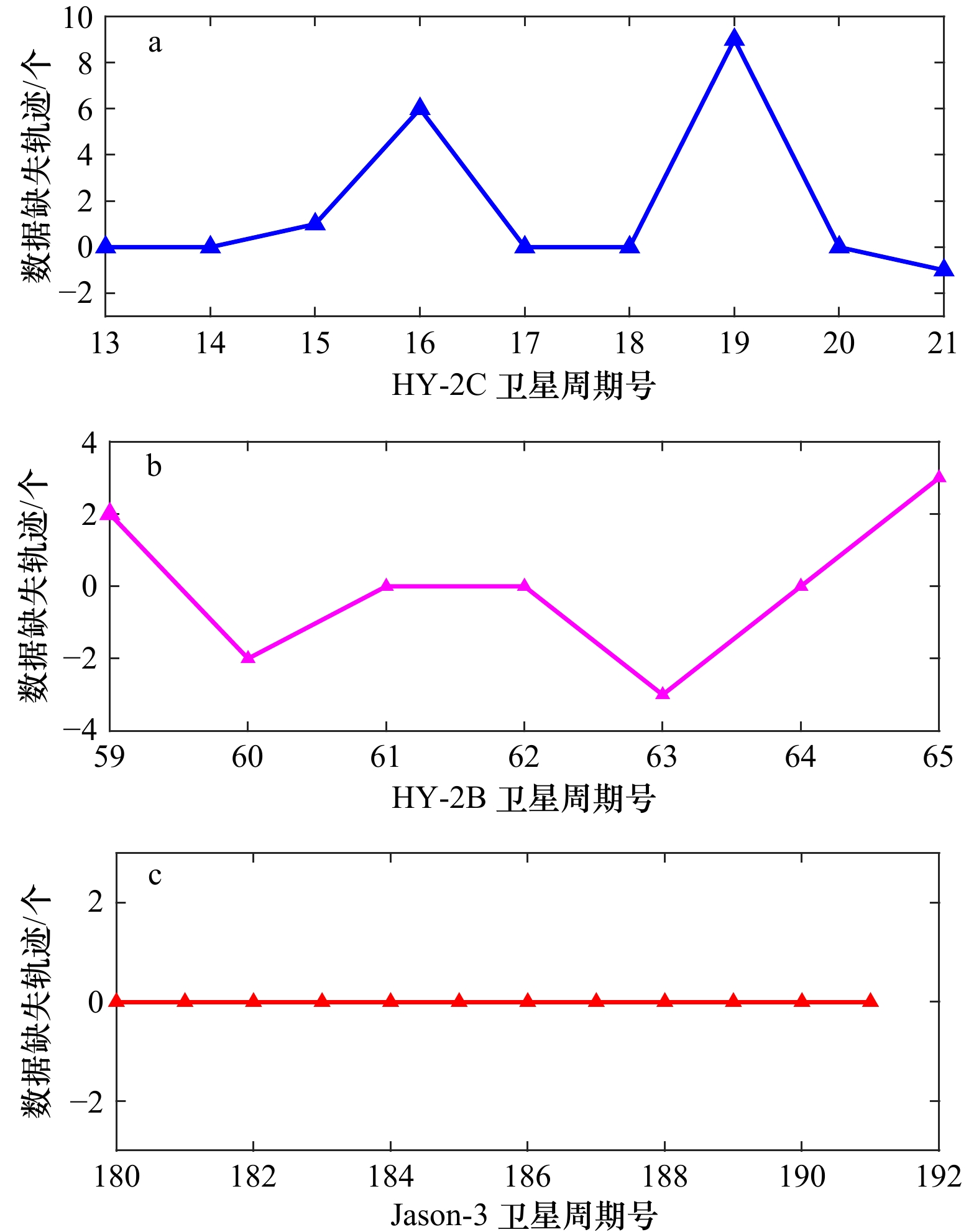
图 1 HY-2C卫星(a)、HY-2B卫星(b)和Jaosn-3卫星(c)不同周期数据缺失轨迹个数
Fig. 1 Data missing pass number of HY-2C satellite (a), HY-2B satellite (b) and Jason-3 satellite (c)
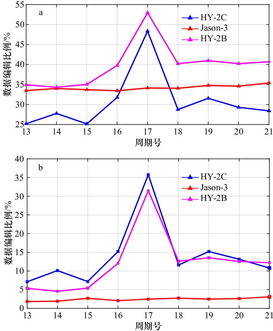
图 2 HY-2C卫星、HY-2B卫星和Jason-3卫星在无海深和纬度约束的数据编辑比例(a)和有海深和纬度约束的数据编辑比例(b)
Fig. 2 The editing ratio of HY-2C satellite, HY-2B satellite and Jason-3 satellite measurements without sea depth and latitude constraints (a) and with depth and latitude constraints (b)
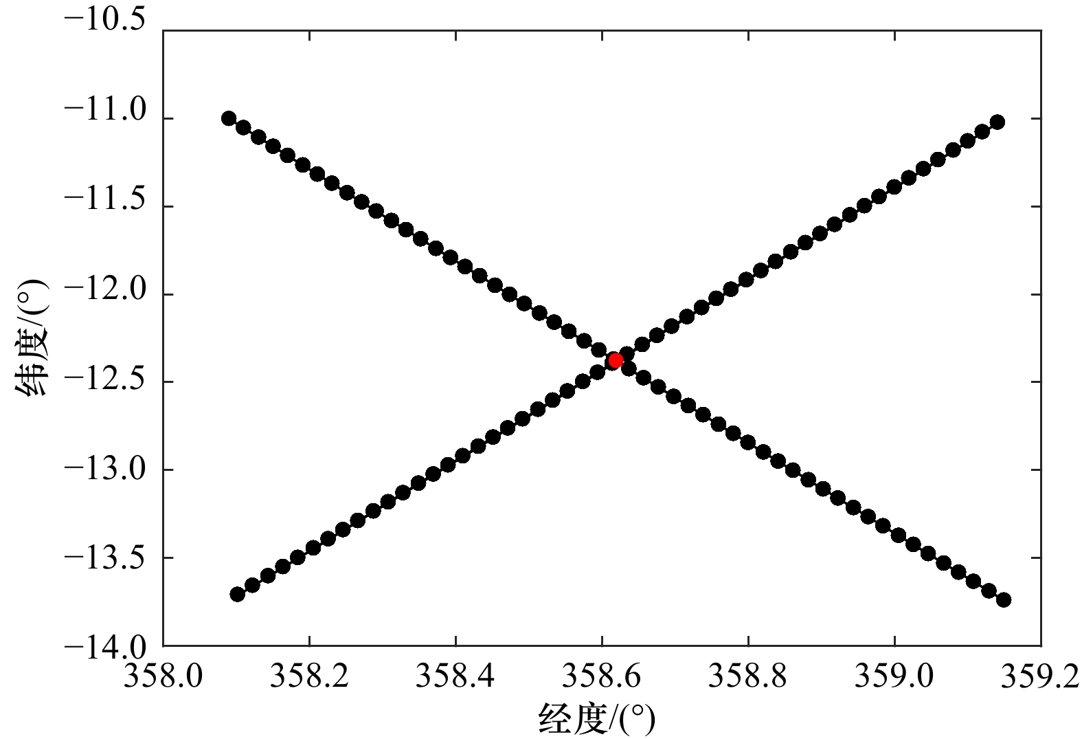
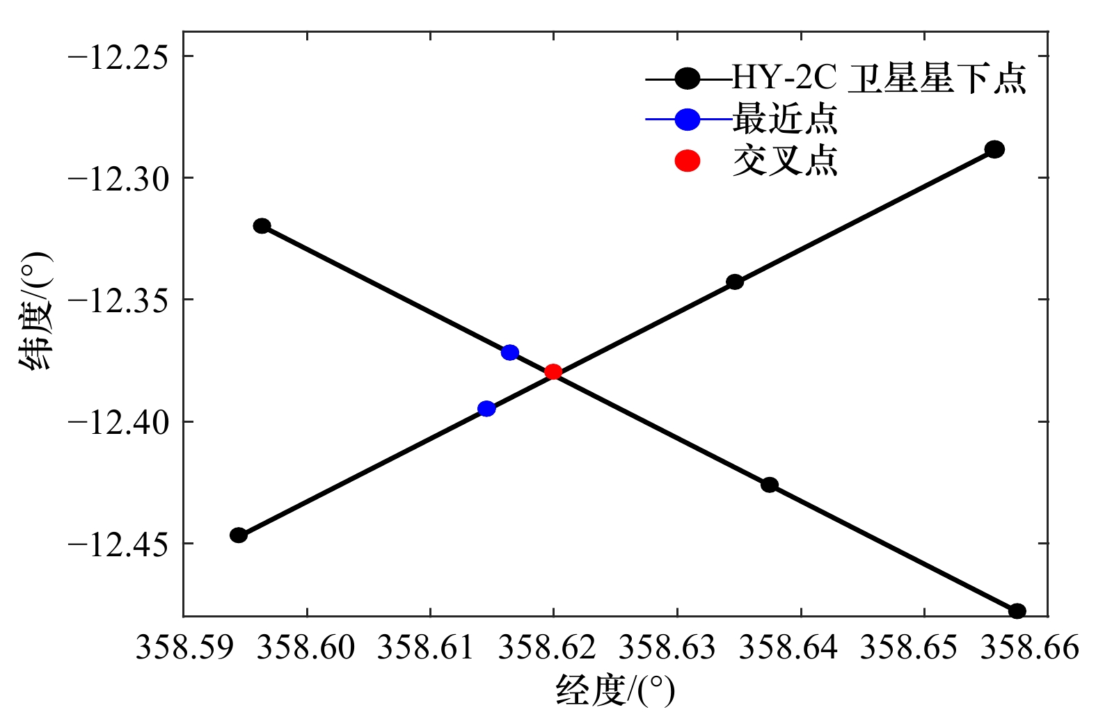
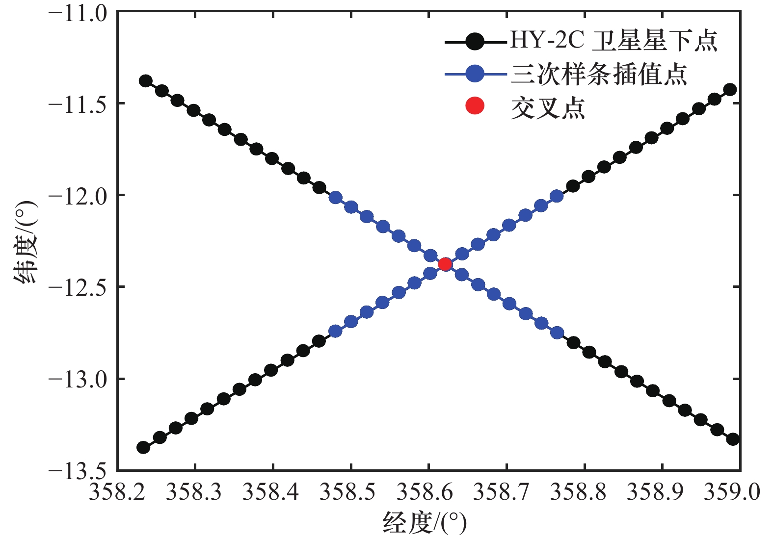
图 3 HY-2C卫星两条轨道星下点之间距离在1°范围内示意图
图中黑色的点是卫星的星下点,红色的点是求出来的精确交叉点的位置
Fig. 3 Schematic diagram of the distance between the sub-satellite points of the two orbits of the HY-2C satellite within 1°
The black dots are altimeter ground tracks, and the red dot is the precise crossover point of along-track

图 7 HY-2C卫星(a)、HY-2B卫星(b)和Jason-3卫星(c)自交叉点海平面高度异常差的平均值(蓝色)和标准差(红色)
Fig. 7 Mean error (blue dotted lines) and standard deviation (red dotted lines) of HY-2C satellite (a), HY-2B satellite (b) and Jason-3 satellite (c) self-crossover sea level anomaly data
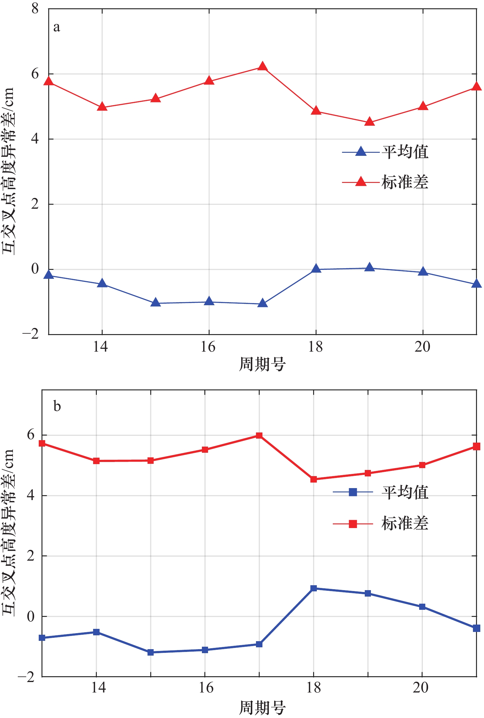
图 8 HY-2C卫星和HY-2B卫星(a)、HY-2C卫星和Jason-3卫星(b)互交叉点海平面高度异常差异的平均值(蓝色)和标准差(红色)
Fig. 8 Mean error (blue dotted lines) and standard deviation (red dotted lines) of HY-2C satellite and HY-2B satellite (a), HY-2C satellite and Jason-3 satellite (b) cross-crossover sea level anomaly differences
表 1 HY-2C卫星、HY-2B卫星和Jason-3卫星高度计和辐射计数据编辑的参数阈值
Tab. 1 Main editing thresholds values of HY-2C satellite, HY-2B satellite and Jason-3 satellite altimeters and microwave radiometers
观测量 最小值 最大值 20 Hz测距数目 10 − 20 Hz测距标准差/mm 0 200 轨道高度−测距值/mm −130 000 100 000 模型干对流层校正/mm −2 500 −1 900 辐射计湿对流层校正/mm −500 −1 Ku波段电离层校正/mm −400 40 Ku波段海况偏差/mm −500 0 潮汐校正/mm −5 000 5 000 固体潮校正/mm −1 000 1 000 极潮校正/mm −150 150 Ku波段有效波高/mm 0 11 000 Ku波段向后散射系数/dB 7 30 风速/(m·s−1) −0 30 Ku波段偏指向角平方/(°)2 −0.2 0.64 后向散射系数标准差/dB − 1 后向散射系数观测数 10 −  下载: 导出CSV
表 2 HY-2C卫星自交叉点海面高度异常数据精度的比较
Tab. 2 Comparison of accuracy in HY-2C satellite self-crossover sea level anomaly data
临近点插值 最近点插值 三次样条插值 交叉点数量(SLA<20 cm) 14 746 14 699 14 312 平均值/cm 0.03 0.03 0.03 标准差/cm 6.63 6.89 6.17
下载: 导出CSV
表 3 HY-2B卫星自交叉点海面高度异常数据精度的比较
Tab. 3 Comparison of accuracy in HY-2B satellite self-crossover sea level anomaly data
临近点插值 最近点插值 三次样条插值 交叉点数量(SLA<20 cm) 5 005 5 045 4 936 平均值/cm 0.01 0 0.01 标准差/cm 4.60 5.1 4.21
下载: 导出CSV
表 4 Jason-3卫星自交叉点海面高度异常数据精度的比较
Tab. 4 Comparison of accuracy in Jason-3 satellite self-crossover sea level anomaly data
临近点插值 最近点插值 三次样条插值 交叉点数量(SLA<20 cm) 22 639 22 610 22 233 平均值/cm −0.01 −0.01 0 标准差/cm 6.63 5.45 4.70
下载: 导出CSV
表 5 HY-2C卫星和HY-2B卫星、Jason-3卫星互交叉点海面高度异常数据精度的比较
Tab. 5 Comparison of accuracy in HY-2C satellite and HY-2B satellite, HY-2C satellite and Jason-3 satellite cross-crossover sea level anomaly data
HY-2C和HY-2B HY-2C和Jason-3 交叉点数(SLA<20 cm) 15 470 15 799 平均值/cm −0.47 −0.3 标准差/cm 5.32 5.32
下载: 导出CSV
-
[1] 刘亚龙. HY-2雷达高度计海面高度定标技术研究[D]. 青岛: 中国海洋大学, 2014.Liu Yalong. Caliration technology for HY-2 radar altimeter sea surface height[D]. Qingdao: Ocean University of China, 2014. [2] 汪栋. HY-2卫星高度计仪器误差评估与校正研究[D]. 青岛: 中国海洋大学, 2013.Wang Dong. The research for evaluations and corrections of HY-2 satellite altimeter instrument error[D]. Qingdao: Ocean University of China, 2013. [3] Sepulveda H H, Queffeulou P, Ardhuin F. Assessment of SARAL/AltiKa wave height measurements relative to buoy, Jason-2, and Cryosat-2 data[J]. Marine Geodesy, 2015, 38(S1): 449−465. [4] Dorandeu J, Ablain M, Faugère Y, et al. Jason-1 global statistical evaluation and performance assessment: calibration and cross-calibration results[J]. Marine Geodesy, 2004, 27(3/4): 345−372. [5] Ablain M, Philipps S, Picot N, et al. Jason-2 global statistical assessment and cross-calibration with Jason-1[J]. Marine Geodesy, 2010, 33(S1): 162−185. [6] Jiang Xingwei, Jia Yongjun, Zhang Youguang. Measurement analyses and evaluations of sea-level heights using the HY-2A satellite’s radar altimeter[J]. Acta Oceanologica Sinica, 2019, 38(11): 134−139. doi: 10.1007/s13131-019-1503-6 [7] Jia Yongjun, Yang Jungang, Lin Mingsen, et al. Global assessments of the HY-2B measurements and cross-calibrations with Jason-3[J]. Remote Sensing, 2020, 12(15): 2470. doi: 10.3390/rs12152470 [8] 杨磊, 周兴华, 林明森, 等. HY-2A卫星雷达高度计全球IGDR数据质量评估[J]. 地球物理学进展, 2016, 31(2): 629−636.Yang Lei, Zhou Xinghua, Lin Mingsen, et al. Global statistical assessment of HY-2A altimeter IGDR data[J]. Progress in Geophysics, 2016, 31(2): 629−636. [9] 刘治中, 杨俊钢, 张杰, 等. 基于与Jason-2数据比对的Jason-3卫星高度计全球数据质量评估[J]. 海洋学报, 2020, 42(3): 129−139.Liu Zhizhong, Yang Jungang, Zhang Jie, et al. Jason-3 global statistical assessment based on Jason-2[J]. Haiyang Xuebao, 2020, 42(3): 129−139. [10] Ji Min, Ma Huadong, Li Gang, et al. Quality evaluation of sea level height data of Jason-3 satellite based on Jason-2[C]//Proceedings of the 7th International Conference on Geoinformatics in Sustainable Ecosystem and Society. Guangzhou: Springer, 2019: 103−121. [11] Wang Zhixiong, Zou Juhong, Stoffelen A, et al. Scatterometer sea surface wind product validation for HY-2C[J]. IEEE Journal of Selected Topics in Applied Earth Observations and Remote Sensing, 2021, 14: 6156−6164. doi: 10.1109/JSTARS.2021.3087742 [12] Kong Qiaoli, Guo Jinyun, Sun Yu, et al. Centimeter-level precise orbit determination for the HY-2A satellite using DORIS and SLR tracking data[J]. Acta Geophysica, 2017, 65(1): 1−12. doi: 10.1007/s11600-016-0001-x [13] Wang Jichao, Yu Ting, Deng Fangyu, et al. Acquisition of the wide swath significant wave height from HY-2C through deep learning[J]. Remote Sensing, 2021, 13(21): 4425. doi: 10.3390/rs13214425 [14] 彭海龙, 林明森, 穆博, 等. HY-2A卫星雷达高度计数据的全球统计评价及质量分析[J]. 海洋学报, 2015, 37(7): 54−66.Peng Hailong, Lin Mingsen, Mu Bo, et al. Global statistical evaluation and performance analysis of HY-2A satellite radar altimeter data[J]. Haiyang Xuebao, 2015, 37(7): 54−66. [15] Zaouche G, Perbos J, Lafon T, et al. OSTM/Jason-2: assessment of the system performances (ocean surface topography mission: OSTM)[J]. Marine Geodesy, 2010, 33(S1): 26−52. [16] Wang Jinbo, Lee L F, Qiu Bo, et al. An observing system simulation experiment for the calibration and validation of the surface water ocean topography sea surface height measurement using in situ platforms[J]. Journal of Atmospheric and Oceanic Technology, 2018, 35(2): 281−297. doi: 10.1175/JTECH-D-17-0076.1 [17] 叶小敏, 林明森, 宋庆君. 基于现场观测数据的卫星雷达高度计海面风速和有效波高真实性检验方法研究[J]. 遥感技术与应用, 2014, 29(1): 26−32.Ye Xiaomin, Lin Mingsen, Song Qingjun. Research on validation methods of satellite radar altimeter retrieved sea surface wind speed and significant wave height using in-situ data[J]. Remote Sensing Technology and Application, 2014, 29(1): 26−32. [18] 杨磊, 周兴华, 彭海龙, 等. 基于Jason-2的Saral/AltiKa高度计全球统计评估与交叉定标[J]. 海洋科学进展, 2014, 32(4): 482−490. doi: 10.3969/j.issn.1671-6647.2014.04.005Yang Lei, Zhou Xinghua, Peng Hailong, et al. Global assessment and cross-calibration of Saral/AltiKa based on Jason-2 altimeter[J]. Advances in Marine Science, 2014, 32(4): 482−490. doi: 10.3969/j.issn.1671-6647.2014.04.005 -


计量
- 文章访问数: 1020
- HTML全文浏览量: 286
- PDF下载量: 78
- 被引次数: 0
