

Multiscale Quadtree for denoising spaceborne photon-counting LiDAR
-
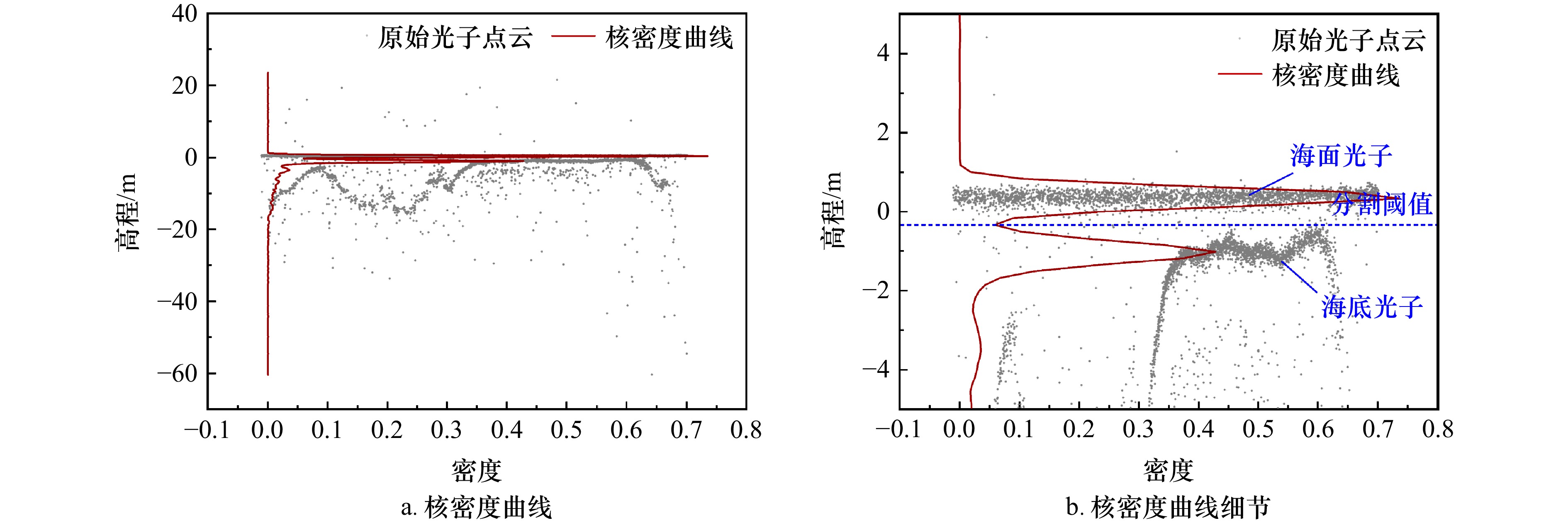
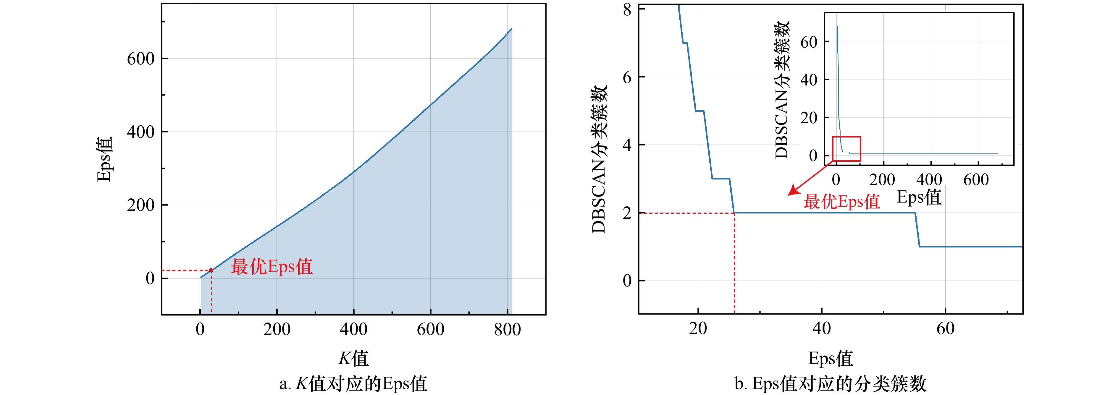
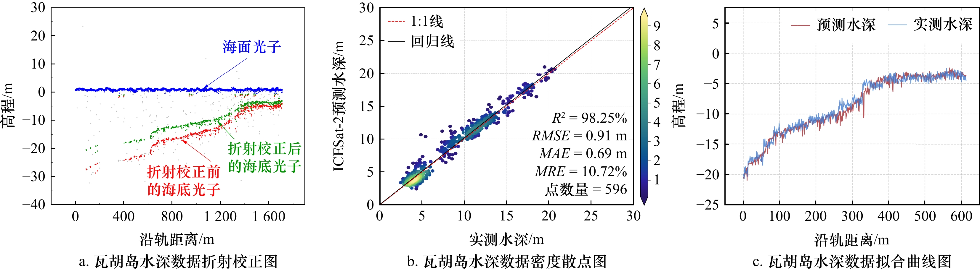
摘要: 第二代星载激光雷达冰、云和陆地测高卫星(Ice, Cloud, and Land Elevation Satellite-2, ICESat-2)在获取浅海岛礁水深信息方面具有极大潜力。然而受大气散射、太阳辐射和仪器噪声等因素影响,造成获取的ICESat-2星载激光光子中存在大量噪声。针对上述问题,本文提出一种基于多尺度分析的四叉树星载激光雷达去噪方法。首先,使用高斯核函数和K折交叉验证的方法绘制光子核密度曲线(Kernel Density Estimation, KDE),并设置阈值来分离海面光子和海底光子;其次,利用自适应参数的DBSCAN(Density-Based Spatial Clustering of Applications with Noise)算法去除海底异常光子,获得粗略去噪结果。最后,对海底光子划分窗口,从不同尺度使用预判断四叉树算法提取出精确的海底信号光子。研究选取典型岛礁的ICESat-2卫星数据,通过与实测水深数据对比,决定系数(R2)分别达到95%和98%,均方根误差(RMSE)分别达到1.01 m和0.77 m。结果表明,该方法能够准确提取水下地形信息,为浅海水下地形反演奠定基础。Abstract: Ice, Cloud, and Land Elevation Satellite-2 (ICESat-2) has excellent potential for obtaining water depth information around islands and reefs. However, due to the influence of atmospheric scattering, solar radiation, instrument noise, ICESat-2 data contains a lot of noise. Combining multiscale analysis with the quadtree algorithm, we propose a new photon-counting LiDAR denoising method to discard the large amount of noise in ICESat-2 data. First, Kernel Density Estimation (KDE) is performed using a Gaussian kernel function and the K-fold cross validation to set threshold values that separate sea surface photons from seafloor photons. Second, abnormal photons are removed using the Density-Based Spatial Clustering of Applications with Noise (DBSCAN) with adaptive parameters, yielding rough denoising results. Finally, for the seafloor photon partition window, accurate seafloor signal photons are extracted across multiple scales using the pre-judgment quadtree. The study used ICESat-2 photon-counting data from typical islands and reefs, comparing it with in situ water depth measurements. The coefficient of determination (R²) in the study area reaches 95% and 98%, with root mean square errors (RMSE) of 1.01 m and 0.77 m, respectively. The results show that the proposed method can accurately extract underwater topographic information, providing a solid foundation for the inversion of shallow marine topography.
-
Key words:
- bathymetry /
- ICESat-2 /
- photon classification /
- kernel density estimation /
- multiscale analysis /
- quadtree
-

图 7 不同光子密度的去噪结果
蓝色点代表海面光子,红色点代表海底光子,灰色点代表噪声光子
Fig. 7 Denoising results of different photon densities
Blue points represent sea surface photons, red points represent seafloor photons, and gray points represent noise photons

图 8 不同海底地形的去噪结果
蓝色点代表海面光子,红色点代表海底光子,灰色点代表噪声光子
Fig. 8 Denoising results of different seafloor terrains
Blue points represent sea surface photons, red points represent seafloor photons, and gray points represent noise photons
表 1 实验区域
Tab. 1 Experimental area
序号 研究区域 采集时间 航迹 波束 范围 a 东岛 2023-08-07 19:59:02 0743 GT3L 16°39′54″~16°41′07″N b 华光礁 2022-07-15 14:36:12 0362 GT1R 16°13′33″~16°14′37″N c 蜈支洲岛 2022-06-28 03:40:53 0095 GT3R 18°18′52″~18°19′01″N d 别克斯岛 2020-07-17 13:08:31 0339 GT1L 18°07′26″~18°07′48″N e 瓦胡岛 2022-09-02 06:13:30 1105 GT3R 21°17′08″~21°18′04″N f 埃林吉纳埃环礁 2022-09-08 08:22:27 1198 GT2R 11°07′12″~11°08′06″N  下载: 导出CSV
表 2 精度评价结果(东岛、蜈支洲岛和别克斯岛)
Tab. 2 Accuracy verification results (Dong Island, Wuzhizhou Island, and Vieques Island)
实验区域 指标 实验方法 ATL03 DBSCAN Quadtree 本文方法 东岛 OA/% 94.7 94.5 94.1 97.8 F1/% 97.2 97.1 96.9 98.9 FPR/% 48.3 48.3 34.7 23.1 蜈支洲岛 OA/% 94.1 96.0 93.7 98.5 F1/% 85.3 91.9 86.9 96.9 FPR/% 0.2 4.8 5.7 1.8 别克斯岛 OA/% 83.6 93.4 93.1 95.3 F1/% 80.0 92.9 92.5 95.4 FPR/% 0.0 1.7 0.6 8.3
下载: 导出CSV
表 3 精度评价结果(华光礁、瓦胡岛和埃林吉纳埃环礁)
Tab. 3 Accuracy verification results (Huaguang Reef, Oahu Island, and Ailinginae Atoll)
实验区域 指标 实验方法 ATL03 DBSCAN Quadtree 本文方法 华光礁 OA/% 95.1 95.8 96.3 99.3 F1/% 97.4 97.8 98.0 99.6 FPR/% 73.9 45.8 17.5 2.6 瓦胡岛 OA/% 96.2 94.5 96.8 97.7 F1/% 98.0 97.1 98.3 98.8 FPR/% 79.8 41.9 25.8 15.7 埃林吉纳埃环礁 OA/% 97.9 98.4 98.5 98.7 F1/% 98.9 99.2 99.3 99.4 FPR/% 55.3 28.2 13.6 1.0
下载: 导出CSV
表 4 不同算法的去噪精度比较
Tab. 4 Comparison of denoising accuracy of different algorithms
研究区域 方法 指标 R²/% RMSE/m MAE/m MRE/% 点数量 东岛 DBSCAN算法 89.0 1.03 0.77 7.53 627 Quadtree算法 75.0 1.35 0.80 7.88 618 本文方法 95.0 1.01 0.77 7.26 696 瓦胡岛 DBSCAN算法 97.0 0.99 0.76 15.64 477 Quadtree算法 96.0 1.28 0.85 16.87 486 本文方法 98.0 0.91 0.69 10.72 596
下载: 导出CSV
-
[1] 杨元喜, 徐天河, 薛树强. 我国海洋大地测量基准与海洋导航技术研究进展与展望[J]. 测绘学报, 2017, 46(1): 1−8. doi: 10.11947/j.AGCS.2017.20160519Yang Yuanxi, Xu Tianhe, Xue Shuqiang. Progresses and prospects in developing marine geodetic datum and marine navigation of China[J]. Acta Geodaetica et Cartographica Sinica, 2017, 46(1): 1−8. doi: 10.11947/j.AGCS.2017.20160519 [2] 马毅, 张杰, 张靖宇, 等. 浅海水深光学遥感研究进展[J]. 海洋科学进展, 2018, 36(3): 331−351. doi: 10.3969/j.issn.1671-6647.2018.03.001Ma Yi, Zhang Jie, Zhang Jingyu, et al. Progress in shallow water depth mapping from optical remote sensing[J]. Advances in Marine Science, 2018, 36(3): 331−351. doi: 10.3969/j.issn.1671-6647.2018.03.001 [3] Hodúl M, Bird S, Knudby A, et al. Satellite derived photogrammetric bathymetry[J]. ISPRS Journal of Photogrammetry and Remote Sensing, 2018, 142: 268−277. doi: 10.1016/j.isprsjprs.2018.06.015 [4] Albright A, Glennie C. Nearshore bathymetry from fusion of Sentinel-2 and ICESat-2 observations[J]. IEEE Geoscience and Remote Sensing Letters, 2021, 18(5): 900−904. doi: 10.1109/LGRS.2020.2987778 [5] Caballero I, Stumpf R P. Retrieval of nearshore bathymetry from Sentinel-2A and 2B satellites in South Florida coastal waters[J]. Estuarine, Coastal and Shelf Science, 2019, 226: 106277. doi: 10.1016/j.ecss.2019.106277 [6] Ranndal H, Sigaard Christiansen P, Kliving P, et al. Evaluation of a statistical approach for extracting shallow water bathymetry signals from ICESat-2 ATL03 photon data[J]. Remote Sensing, 2021, 13(17): 3548. doi: 10.3390/rs13173548 [7] Parrish C E, Magruder L A, Neuenschwander A L, et al. Validation of ICESat-2 ATLAS bathymetry and analysis of ATLAS’s bathymetric mapping performance[J]. Remote sensing, 2019, 11(14): 1634. doi: 10.3390/rs11141634 [8] 朱笑笑, 王成, 习晓环, 等. ICESat-2星载光子计数激光雷达数据处理与应用研究进展[J]. 红外与激光工程, 2020, 49(11): 20200259. doi: 10.3788/IRLA20200259Zhu Xiaoxiao, Wang Cheng, Xi Xiaohuan, et al. Research progress of ICESat-2/ATLAS data processing and applications[J]. Infrared and Laser Engineering, 2020, 49(11): 20200259. doi: 10.3788/IRLA20200259 [9] 方勇, 曹彬才, 高力, 等. 激光雷达测绘卫星发展及应用[J]. 红外与激光工程, 2020, 49(11): 20201044. doi: 10.3788/IRLA20201044Fang Yong, Cao Bincai, Gao Li, et al. Development and application of lidar mapping satellite[J]. Infrared and Laser Engineering, 2020, 49(11): 20201044. doi: 10.3788/IRLA20201044 [10] 焦慧慧, 谢俊峰, 刘仁, 等. 星载对地观测光子计数激光雷达去噪方法浅析[J]. 航天返回与遥感, 2021, 42(5): 140−150. doi: 10.3969/j.issn.1009-8518.2021.05.015Jiao Huihui, Xie Junfeng, Liu Ren, et al. Discussion on denoising method of photon counting LiDAR for satellite ground observation[J]. Spacecraft Recovery & Remote Sensing, 2021, 42(5): 140−150. doi: 10.3969/j.issn.1009-8518.2021.05.015 [11] Magruder L A, Wharton M E, Stout K D, et al. Noise filtering techniques for photon-counting ladar data[C]//Proceedings of SPIE the International Society for Optical Engineering. Baltimore: SPIE, 2012: 237−245. [12] Herzfeld U C, McDonald B W, Wallin B F, et al. Algorithm for detection of ground and canopy cover in micropulse photon-counting lidar altimeter data in preparation for the ICESat-2 mission[J]. IEEE Transactions on Geoscience and Remote Sensing, 2014, 52(4): 2109−2125. [13] Xie Huan, Xu Qi, Ye Dan, et al. A comparison and review of surface detection methods using MBL, MABEL, and ICESat-2 photon-counting laser altimetry data[J]. IEEE Journal of Selected Topics in Applied Earth Observations and Remote Sensing, 2021, 14: 7604−7623. [14] Xie Huan, Ye Dan, Xu Qi, et al. A density-based adaptive ground and canopy detecting method for ICESat-2 photon-counting data[J]. IEEE Transactions on Geoscience and Remote Sensing, 2022, 60: 4411813. [15] Zhang Jiashu, Kerekes J, Csatho B, et al. A clustering approach for detection of ground in micropulse photon-counting LiDAR altimeter data[C]//Proceedings of 2014 IEEE Geoscience and Remote Sensing Symposium. Quebec City: IEEE, 2014: 177−180. [16] 谢锋, 杨贵, 舒嵘, 等. 方向自适应的光子计数激光雷达滤波方法[J]. 红外与毫米波学报, 2017, 36(1): 107−113. doi: 10.11972/j.issn.1001-9014.2017.01.019Xie Feng, Yang Gui, Shu Rong, et al. An adaptive directional filter for photon counting Lidar point cloud data[J]. Journal of Infrared and Millimeter Waves, 2017, 36(1): 107−113. doi: 10.11972/j.issn.1001-9014.2017.01.019 [17] Chen Bowei, Pang Yong, Li Zengyuan, et al. Ground and top of canopy extraction from photon-counting LiDAR data using local outlier factor with ellipse searching area[J]. IEEE Geoscience and Remote Sensing Letters, 2019, 16(9): 1447−1451. doi: 10.1109/LGRS.2019.2899011 [18] Ma Yue, Xu Nan, Sun Jinyan, et al. Estimating water levels and volumes of lakes dated back to the 1980s using Landsat imagery and photon-counting lidar datasets[J]. Remote Sensing of Environment, 2019, 232: 111287. doi: 10.1016/j.rse.2019.111287 [19] Ma Yue, Zhang Wenhao, Sun Jinyan, et al. Photon-counting lidar: an adaptive signal detection method for different land cover types in coastal areas[J]. Remote Sensing, 2019, 11(4): 471. doi: 10.3390/rs11040471 [20] Zhu Xiaoxiao, Nie Sheng, Wang Cheng, et al. A noise removal algorithm based on OPTICS for photon-counting LiDAR data[J]. IEEE Geoscience and Remote Sensing Letters, 2021, 18(8): 1471−1475. doi: 10.1109/LGRS.2020.3003191 [21] Zhang Guoping, Xu Qing, Xing Shuai, et al. A noise-removal algorithm without input parameters based on quadtree isolation for photon-counting LiDAR[J]. IEEE Geoscience and Remote Sensing Letters, 2022, 19: 6501905. [22] Huang Guoan, Dong Zhipeng, Liu Yanxiong, et al. An optimized denoising method for ICESat-2 photon-counting data considering heterogeneous density and weak connectivity[J]. Optics Express, 2023, 31(25): 41496−41517. doi: 10.1364/OE.502934 [23] Song Yue, Ma Yue, Zhou Zhibiao, et al. Signal photon extraction and classification for ICESat-2 photon-counting lidar in coastal areas[J]. Remote Sensing, 2024, 16(7): 1127. doi: 10.3390/rs16071127 [24] Xie Huan, Xu Qi, Luan Kuifeng, et al. Evaluating ICESat-2 seafloor photons by underwater light-beam propagation and noise modeling[J]. IEEE Transactions on Geoscience and Remote Sensing, 2024, 62: 4203018. [25] Davis R A, Lii K S, Politis D N. Remarks on some nonparametric estimates of a density function[M]//Davis R A, Lii K S, Politis D N. Selected Works of Murray Rosenblatt. New York: Springer, 2011: 95−100. [26] Parzen E. On estimation of a probability density function and mode[J]. The Annals of Mathematical Statistics, 1962, 33(3): 1065−1076. doi: 10.1214/aoms/1177704472 [27] Ester M, Kriegel H P, Sander J, et al. A density-based algorithm for discovering clusters in large spatial databases with noise[C]//Proceedings of the Second International Conference on Knowledge Discovery and Data Mining. Portland: AAAI Press, 1996: 226−231. [28] 孟文君, 李杰, 张凯, 等. 基于改进DBSCAN算法的ICESat-2海面点数据去噪处理及精度评估[J]. 海洋通报, 2021, 40(6): 675−682. doi: 10.11840/j.issn.1001-6392.2021.06.008Meng Wenjun, Li Jie, Zhang Kai, et al. De-noising and accuracy evaluation of ICESAT-2 sea surface data based on DBSCAN algorithm[J]. Marine Science Bulletin, 2021, 40(6): 675−682. doi: 10.11840/j.issn.1001-6392.2021.06.008 [29] Finkel R A, Bentley J L. Quad trees a data structure for retrieval on composite keys[J]. Acta Informatica, 1974, 4(1): 1−9. doi: 10.1007/BF00288933 [30] Otsu N. A threshold selection method from gray-level histograms[J]. IEEE Transactions on Systems, Man, and Cybernetics, 1979, 9(1): 62−66. doi: 10.1109/TSMC.1979.4310076 [31] Zheng Xuebo, Hou Chunping, Huang Meiyan, et al. A density and distance-based method for ICESat-2 photon-counting data denoising[J]. IEEE Geoscience and Remote Sensing Letters, 2023, 20: 6500405. [32] Egbert G D, Erofeeva S Y. Efficient inverse modeling of barotropic ocean tides[J]. Journal of Atmospheric and Oceanic technology, 2002, 19(2): 183−204. doi: 10.1175/1520-0426(2002)019<0183:EIMOBO>2.0.CO;2 [33] Bargaoui Z K, Chebbi A. Comparison of two kriging interpolation methods applied to spatiotemporal rainfall[J]. Journal of Hydrology, 2009, 365(1/2): 56−73. -


计量
- 文章访问数: 410
- HTML全文浏览量: 221
- PDF下载量: 17
- 被引次数: 0
