

The estimation of Antarctic sea ice thickness from multi-source satellite radar altimeters
-
摘要: 南极海冰是极地气候系统的重要组成部分,对全球气候有着深远影响。海冰厚度作为海冰的关键属性之一,了解其时空分布特征和变化趋势对理解和预估气候变化进程具有重要意义。然而,目前对于南极海冰厚度的监测局限在时空分布有限的实地观测和短时间序列的卫星观测阶段,长时间序列的冰厚数据仍然缺失。针对这一问题,基于时空连续的卫星雷达高度计Envisat和CryoSat-2,构建了一致性较高的雷达干舷高度数据,定量估算了高度计雷达信号在积雪中的穿透深度,发展了一种适用于南极海冰的厚度遥感估算方法。估算的冰厚与Australian Antarctic Data Centre实测数据的平均绝对偏差约为0.28 m;与ICESat激光雷达高度计冰厚的平均绝对偏差约为0.65 m,相关系数为0.71,一致性较高。2002–2023年南极海冰厚度时空变化分析结果表明,厚冰主要分布于西威德尔海和别林斯高晋海/阿蒙森海,其他海域海冰相对较薄。南极海冰厚度在2011年之前呈现轻微降低趋势,在2011年后加速降低(−0.03 m/a)。南极海冰厚度的分布和变化趋势存在明显的季节和区域特征。Abstract: Antarctic sea ice is a crucial component of the polar climate system, with profound implications for global climate. Sea ice thickness, as one of the key properties of sea ice, holds significant importance for understanding and predicting the influences of climate change by revealing its spatial and temporal distribution patterns and variation trends. However, current monitoring of Antarctic sea ice thickness is constrained by limited ground observations with restricted spatial and temporal coverage or short-term satellite observations, long-term sea ice thickness data remains elusive. To address this issue, this study utilized the continuous satellite radar altimetry data from Envisat and CryoSat-2 and constructed a consistent dataset of radar freeboard of Antarctic sea ice. Then, the penetration depth of radar signals through the snow covers over Antarctic sea ice was quantitatively estimated, and a method applicable to various sea ice-snow scenarios for estimating Antarctic sea ice thickness was developed. The estimated sea ice thickness shows an average absolute bias of approximately 0.28 m compared to in situ measurements from the Australian Antarctic Data Centre, and an average absolute bias of approximately 0.65 m compared to ICESat laser altimeter with a high correlation coefficient of 0.71. Analysis of the spatiotemporal variations of Antarctic sea ice thickness from 2002 to 2023 reveals that thick ice is predominantly concentrated in the western Weddell Sea and Bellingshuan/Amundsen Seas, while ice in other sea sectors is relatively thin. Antarctic sea ice thickness exhibited a slight decreasing trend before 2011, followed by an accelerated decline after 2011 (−0.03 m/a). The distribution and trends of Antarctic sea ice thickness exhibit distinct seasonal and regional characteristics.
-
Key words:
- sea ice thickness /
- sea ice freeboard /
- radar signal penetration depth /
- radar altimeters /
- Antarctica
-

图 1 OIB机载观测数据(a)、ASPeCt船载观测数据和AADC实测数据的空间分布(b)
图中经度线为南极6个子海域的分界线
Fig. 1 The spatial distributions of OIB airborne measurements (a), ASPeCt shipborne observations and AADC in situ measurements (b)
The longitude lines show the boundary of six sea sectors in Antarctica
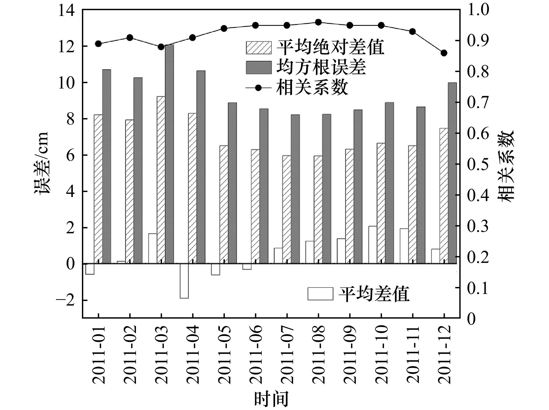
图 2 2011年基于Envisat和CryoSat-2雷达高度计的雷达干舷高度对比
Fig. 2 The comparisons of radar freeboard estimates from Envisat and CryoSat-2 in 2011
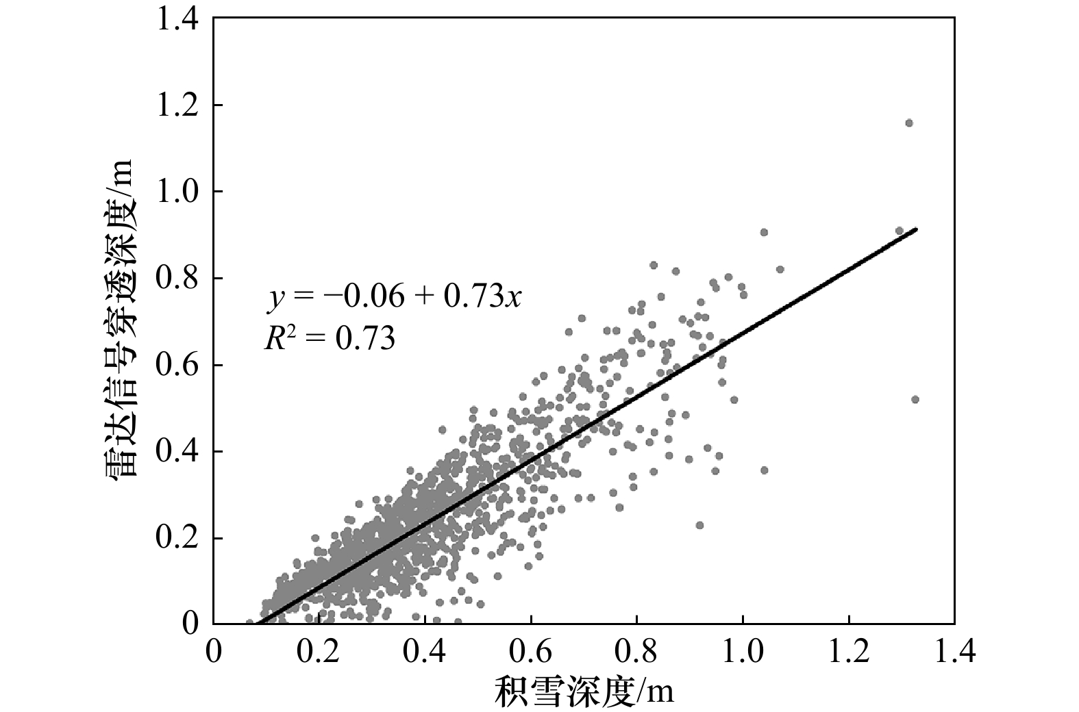
图 3 雷达信号穿透深度与积雪深度的散点图
Fig. 3 The scatter diagram of the radar penetration depth and snow depth
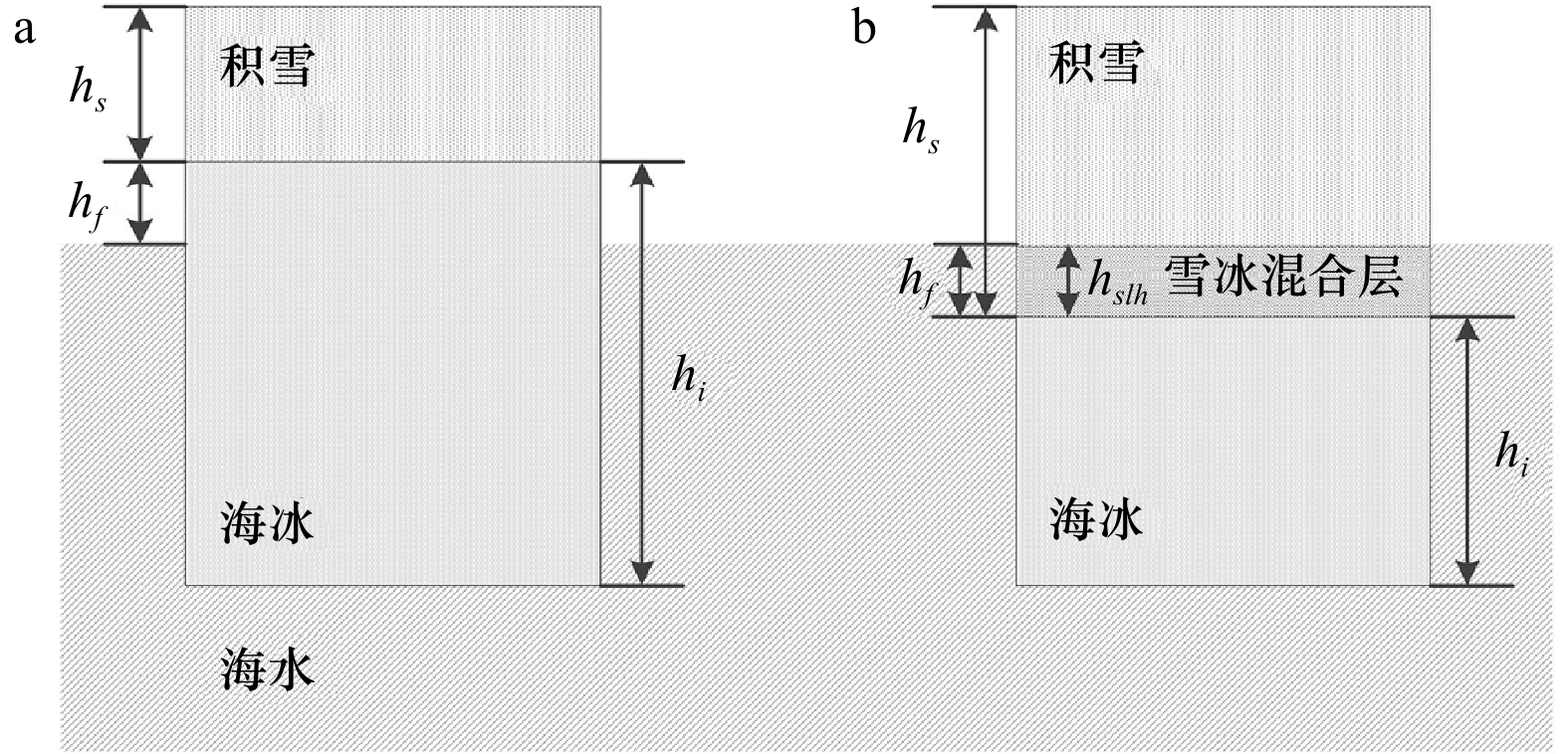
图 4 南极海冰静力平衡示意图
a.正海冰干舷高度,b.负海冰干舷高度
Fig. 4 The schematic diagram of hydrostatic balanceof Antarctic sea ice
a. Positive ice freeboard, b. negative ice freeboard

图 5 Envisat与ICESat估算的积雪干舷高度对比
a.经过穿透深度校正,b.未经过穿透深度校正。20031011代指2003年10–11月,其他类似
Fig. 5 The comparisons between the snow freeboard estimates from Envisat and ICESat
a. Corrected for the penetration depth, b. no correction for the penetration depth. 20031011 indicates from October to November in 2003, others are similar

图 6 CryoSat-2与ICESat-2估算的积雪干舷高度对比
a.经过穿透深度校正,b.未经过穿透深度校正
Fig. 6 The comparisons between the snow freeboard estimates from CryoSat-2 and ICESat-2
a. Corrected for the penetration depth, b. no correction for the penetration depth
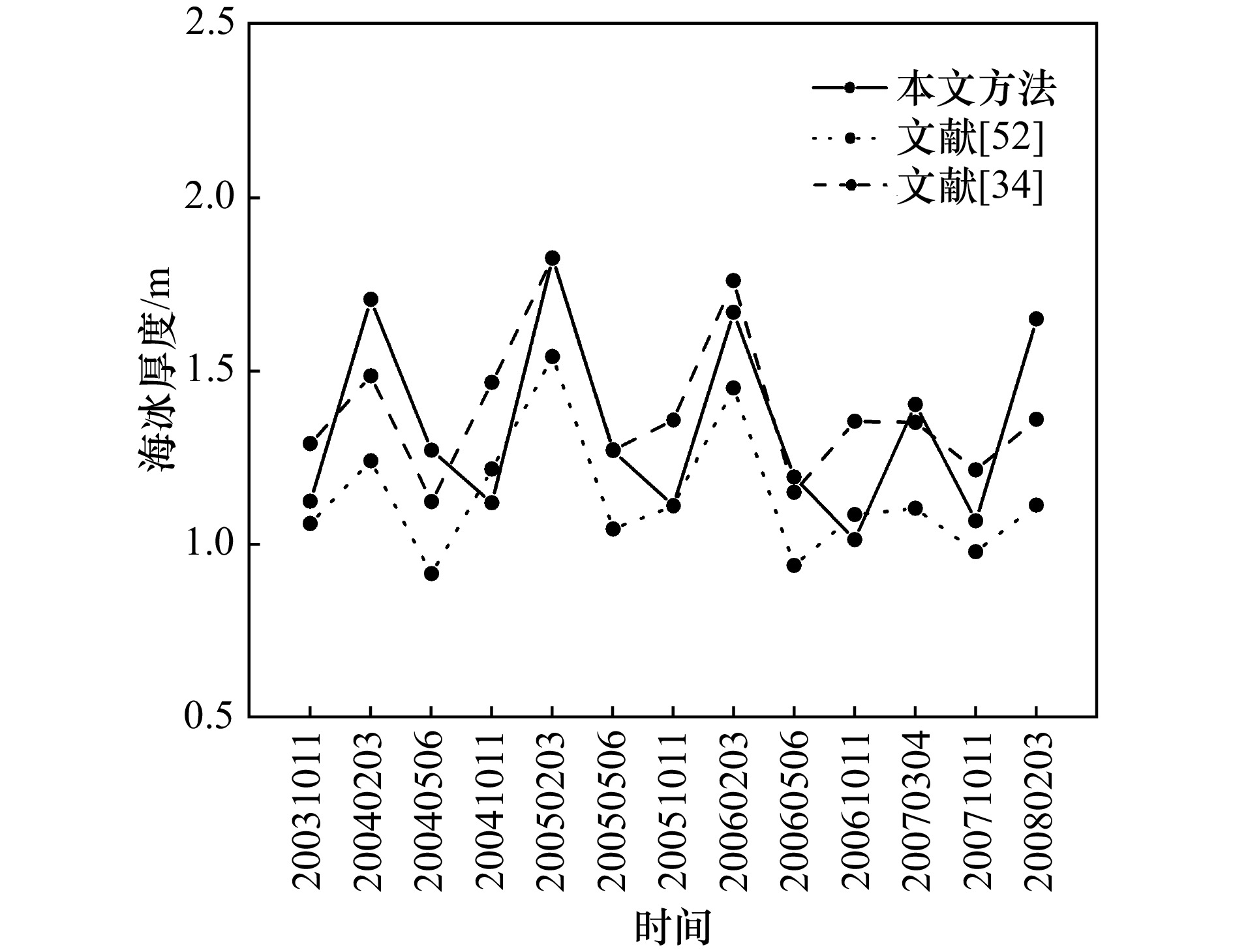
图 7 雷达高度计海冰厚度与两种ICESat海冰厚度的对比
20031011代指2003年10月–11月,其他类似
Fig. 7 The comparison between sea ice thickness estimates from radar altimeters and ICESat (based on two methods)
20031011 indicates from October to November in 2003, other are simlar
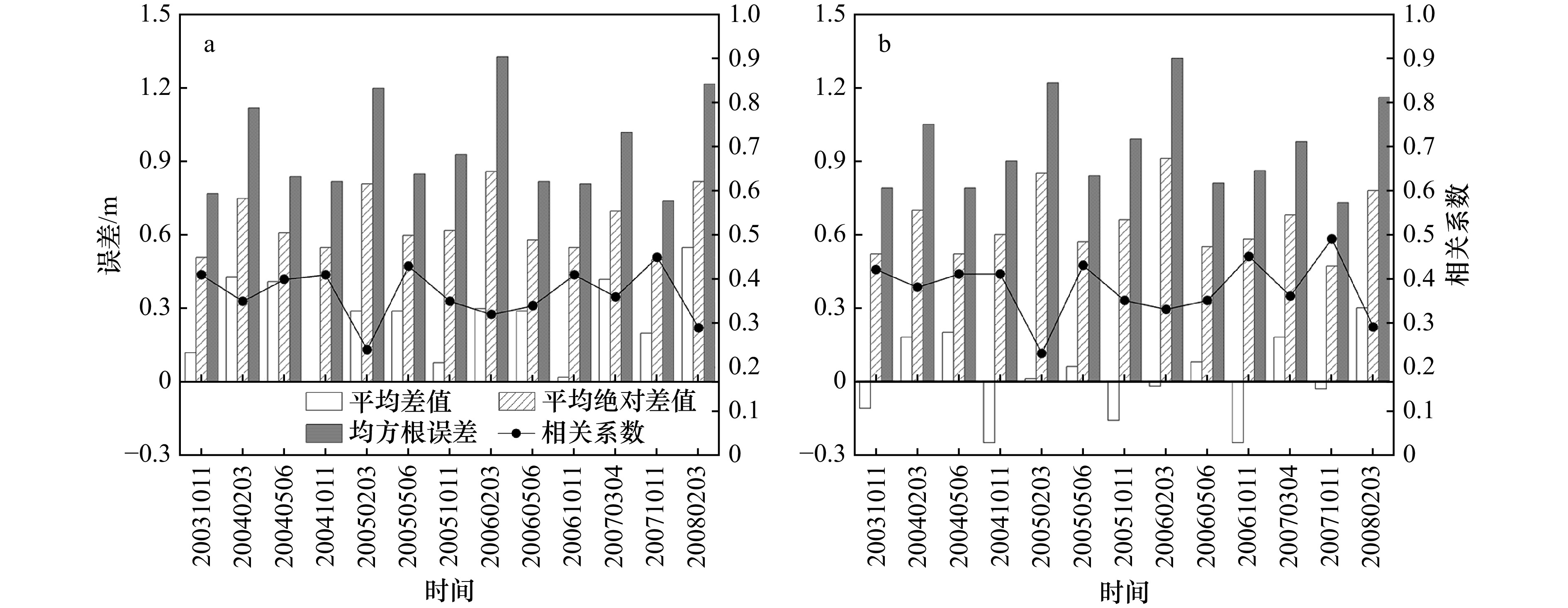
图 8 基于雷达高度计估算的海冰厚度与两种基于ICESat激光雷达高度计估算的海冰厚度的详细对比
a.与文献[52]的对比,b.与文献[34]的对比。20031011代指2003年10月–11月,其他类似
Fig. 8 The detailed comparisons between the sea ice thickness estimates from radar altimeters and sea ice thickness estimates from ICESat (based on two methods)
a. Comparison to reference [52], b. comparison to reference[34]. 20031011 indicates from October to November in 2003, other are simlar

图 9 2002–2010年Envisat时期不同季节平均海冰厚度(a)及其不确定度(b)的空间分布,2011–2023年CryoSat-2时期不同季节平均海冰厚度(c)及其不确定度(d)的空间分布(1~4依次为春季、夏季、秋季和冬季)
Fig. 9 The spatial distributions of averaged sea ice thickness (a) and its uncertainty (b) in different seasons during 2002–2010 (Envisat period); the spatial distributions of averaged sea ice thickness (c) and its uncertainty (d) in different seasons during 2011–2023 (CryoSat-2 period) (the figures 1–4 are in order: spring, summer, autumn and winter)

图 10 2002–2023年海冰厚度的月异常变化
a.南极,b.西威德尔海,c.东威德尔海,d.印度洋海域,e.太平洋海域,f.罗斯海,g.别林斯高晋海/阿蒙森海
Fig. 10 The monthly anomaly variations of Antarctic sea ice thickness estimates from 2002 to 2023
a. Antarctica, b. Western Weddell Sea, c. Eastern Weddell Sea, d. Indian Ocean, e. Pacific Ocean, f. Ross Sea, g. Bellingshausen/Amundsen Seas
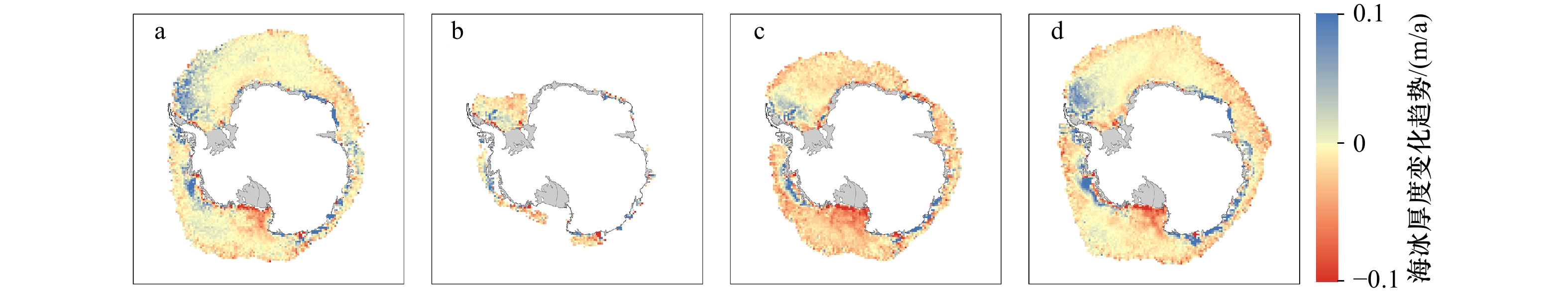
图 11 2002–2023年不同季节南极海冰厚度的空间变化趋势
a.春季,b.夏季,c.秋季,d.冬季
Fig. 11 The spatial distributions of sea ice thickness trends in different seasons from 2002 to 2023
a. Spring, b. summer, c. autumn, d. winter
表 1 Envisat、CryoSat-2、ICESat和ICESat-2数据的基本介绍
Tab. 1 The brief introduction of Envisat, CryoSat-2, ICESat and ICESat-2 data
Envisat CryoSat-2 传感器 Radar Altimeter-2 Synthetic Aperture Interferometric
Radar Altimeter探测波段 Ku波段 Ku波段 空间分辨率 足迹为2~10 km,
足迹间隔约为7 km沿轨约0.3 km,
跨轨约1.5 km重访周期 35 d 30 d 空间范围 82°N~82°S 88°N~88°S ICESat ICESat-2 传感器 Geoscience Laser
Altimeter SystemAdvanced Terrain Laser
Altimeter System空间分辨率 足迹为70 m,
足迹间隔约为170 m足迹为17 m,
足迹间隔约为0.7 m重访周期 183 d 91 d 空间范围 88°N~88°S 88°N~88°S  下载: 导出CSV
表 2 基于不同年份OIB机载测量数据的穿透深度估算公式回归系数
Tab. 2 The regression coefficients of the penetration depth estimation equations based on OIB airborne measurements in different years
样本中被去除数据所在的年份 斜率 截距 格网数 2009 0.76 −0.05 208 2010 0.88 −0.10 196 2012 0.75 −0.09 218 2013 0.51 0.00 98 2014 0.65 −0.04 216 2016 0.68 −0.05 199 2017 1.07 −0.18 79 2018 0.52 0.01 36 应用所有数据 0.73 −0.06 1250
下载: 导出CSV
-
[1] Parkinson C L. A 40-y record reveals gradual Antarctic sea ice increases followed by decreases at rates far exceeding the rates seen in the Arctic[J]. Proceedings of the National Academy of Sciencesof the United States of America, 2019, 116(29): 14414−14423. doi: 10.1073/pnas.1906556116 [2] 杨颖玥, 刘海龙. 南极海冰快速下降历史事件的时空特征分析[J]. 海洋与湖沼, 2023, 54(6): 1564−1572.Yang Yingyue, Liu Hailong. Temporal and spatial characteristics of historical events of rapid decline of Antarctic sea ice[J]. Oceanologia et Limnlolgia Sinica, 2023, 54(6): 1564−1572. [3] 蔡祎, 艾松涛. 基于Argo浮标的南极海冰范围变化分析[J]. 海洋通报, 2021, 40(5): 492−501.Cai Yi, Ai Songtao. Analysis of Antarctic sea ice extent variation based on Argo floats[J]. Marine Science Bulletin, 2021, 40(5): 492−501. [4] 李双林, 韩哲, 刘娜, 等. 2016年南极海冰破纪录减少及其成因的研究综述[J]. 海洋学报, 2021, 43(7): 1−10.Li Shuanglin, Han Zhe, Liu Na, et al. A review of the researches on the record low Antarctic sea ice in 2016 and its formation mechanisms[J]. Haiyang Xuebao, 2021, 43(7): 1−10. [5] 刘玥, 庞小平, 赵羲, 等. 1979–2018年南极海冰边缘区范围时空变化研究[J]. 极地研究, 2021, 33(4): 508−517.Liu Yue, Pang Xiaoping, Zhao Xi, et al. Analysis of temporal and spatial changes in the extent of the Antarctic marginal ice zone from 1979 to 2018[J]. Chinese Journal of Polar Research, 2021, 33(4): 508−517. [6] 柯长青, 金鑫, 沈校熠, 等. 南北极海冰变化及其影响因素的对比分析[J]. 极地研究, 2020, 32(1): 1−12.Ke Changqing, Jin Xin, Shen Xiaoyi, et al. Comparison of Antarctic and Arctic sea ice variations and their impact factors[J]. Chinese Journal of Polar Research, 2020, 32(1): 1−12. [7] 刘森, 邹斌, 石立坚, 等. 基于FY-3C微波辐射计数据的极区海冰密集度反演方法研究[J]. 海洋学报, 2020, 42(1): 113−122. doi: 10.3969/j.issn.0253-4193.2020.01.012Liu Sen, Zou Bin, Shi Lijian, et al. Polar sea ice concentration retrieval based on FY-3C microwave radiation imager data[J]. Haiyang Xuebao, 2020, 42(1): 113−122. doi: 10.3969/j.issn.0253-4193.2020.01.012 [8] 张雷, 徐宾, 师春香, 等. 基于卫星气候资料的1989-2015年南北极海冰面积变化分析[J]. 冰川冻土, 2017, 39(6): 1163−1171.Zhang Lei, Xu Bin, Shi Chunxiang, et al. Analysis of sea ice area change in the Arctic and Antarctic based on the satellite climate data during1989-2015[J]. Journal of Glaciology and Geocryology, 2017, 39(6): 1163−1171. [9] Willmes S, Nicolaus M, Haas C. The microwave emissivity variability of snow covered first-year sea ice from late winter to early summer: a model study[J]. The Cryosphere, 2014, 8(3): 891−904. doi: 10.5194/tc-8-891-2014 [10] Ozsoy-Cicek B, Ackley S, Xie Hongjie, et al. Sea ice thickness retrieval algorithms based on in situ surface elevation and thickness values for application to altimetry[J]. Journal of Geophysical Research: Oceans, 2013, 118(8): 3807−3822. doi: 10.1002/jgrc.20252 [11] Worby A P, Geiger C A, Paget M J, et al. Thickness distribution of Antarctic sea ice[J]. Journal of Geophysical Research: Oceans, 2008, 113(C5): C05S92. [12] 唐述林, 李宁. 基于走航观测的夏季南极海冰分布特征分析[J]. 冰川冻土, 2008, 30(2): 211−217.Tang Shulin, Li Ning. Analysis of the signature of summer Antarctic sea ice distribution by ship-based ice observation[J]. Journal of Glaciology and Geocryology, 2008, 30(2): 211−217. [13] Fichefet T, Goosse H, Morales Maqueda M A. A hindcast simulation of Arctic and Antarctic sea ice variability, 1955–2001[J]. Polar Research, 2003, 22(1): 91−98. [14] Fichefet T, Tartinville B, Goosse H. Antarctic sea ice variability during 1958–1999: a simulation with a global ice-ocean model[J]. Journal of Geophysical Research: Oceans, 2003, 108(C3): 3102. [15] Zhang Jinlun. Increasing Antarctic sea ice under warming atmospheric and oceanic conditions[J]. Journal of Climate, 2007, 20(11): 2515−2529. doi: 10.1175/JCLI4136.1 [16] Vancoppenolle M, Timmermann R, Ackley S F, et al. Assessment of radiation forcing data sets for large-scale sea ice models in the Southern Ocean[J]. Deep-Sea Research Part II: Topical Studies in Oceanography, 2011, 58(9/10): 1237−1249. [17] Massonnet F, Mathiot P, Fichefet T, et al. A model reconstruction of the Antarctic sea ice thickness and volume changes over 1980−2008 using data assimilation[J]. Ocean Modelling, 2013, 64: 67−75. doi: 10.1016/j.ocemod.2013.01.003 [18] Shu Q, Song Z, Qiao F. Assessment of sea ice simulations in the CMIP5 models[J]. The Cryosphere, 2015, 9(1): 399−409. doi: 10.5194/tc-9-399-2015 [19] Shu Qi, Wang Qiang, Song Zhenya, et al. Assessment of sea ice extent in CMIP6 with comparison to observations and CMIP5[J]. Geophysical Research Letters, 2020, 47(9): e2020GL087965. doi: 10.1029/2020GL087965 [20] 王今菲, 杨清华, 于乐江, 等. 南极海冰变化及其气候效应研究述评[J]. 海洋学报, 2021, 43(7): 11−22.Wang Jinfei, Yang Qinghua, Yu Lejiang, et al. A review on Antarctic sea ice change and its climate effects[J]. Haiyang Xuebao, 2021, 43(7): 11−22. [21] Karvonen J, Cheng B, Vihma T, et al. A method for sea ice thickness and concentration analysis based on SAR data and a thermodynamic model[J]. The Cryosphere, 2012, 6(6): 1507−1526. doi: 10.5194/tc-6-1507-2012 [22] Kwok R, Nghiem S V, Yueh S H, et al. Retrieval of thin ice thickness from multifrequency polarimetric SAR data[J]. Remote sensing of environment, 1995, 51(3): 361−374. doi: 10.1016/0034-4257(94)00017-H [23] Laxon S, Peacock N, Smith D. High interannual variability of sea ice thickness in the Arctic region[J]. Nature, 2003, 425(6961): 947−950. doi: 10.1038/nature02050 [24] Kwok R. Arctic sea ice thickness, volume, and multiyear ice coverage: losses and coupled variability (1958–2018)[J]. Environmental Research Letters, 2018, 13(10): 105005. doi: 10.1088/1748-9326/aae3ec [25] Kwok R, Rothrock D A. Decline in Arctic sea ice thickness from submarine and ICESat records: 1958–2008[J]. Geophysical Research Letters, 2009, 36(15): L15501. [26] Laxon S W, Giles K A, Ridout A L, et al. CryoSat-2 estimates of Arctic sea ice thickness and volume[J]. Geophysical Research Letters, 2013, 40(4): 732−737. doi: 10.1002/grl.50193 [27] Giles K A, Laxon S W, Worby A P. Antarctic sea ice elevation from satellite radar altimetry[J]. Geophysical Research Letters, 2008, 35(3): L03503. [28] Schwegmann S, Rinne E, Ricker R, et al. About the consistency between Envisat and CryoSat-2 radar freeboard retrieval over Antarctic sea ice[J]. The Cryosphere, 2016, 10(4): 1415−1425. doi: 10.5194/tc-10-1415-2016 [29] Kwok R, Kacimi S. Three years of sea ice freeboard, snow depth, and ice thickness of the Weddell Sea from Operation IceBridge and CryoSat-2[J]. The Cryosphere, 2018, 12(8): 2789−2801. doi: 10.5194/tc-12-2789-2018 [30] 陈亦卓, 季青, 庞小平. 基于CryoSat-2卫星测高数据分析南极海冰厚度的时空变化[J]. 冰川冻土, 2019, 41(5): 1214−1220.Chen Yizhuo, Ji Qing, Pang Xiaoping. Spatio-temporal variation of Antarctic sea ice thickness using Cryosat-2 satellite altimeter data[J]. Journalof Glaciology and Geocryology, 2019, 41(5): 1214−1220. [31] Yi Donghui, Zwally H J, Robbins J W. ICESat observations of seasonal and interannual variations of sea-ice freeboard and estimated thickness in the Weddell Sea, Antarctica (2003–2009)[J]. Annals of Glaciology, 2011, 52(57): 43−51. doi: 10.3189/172756411795931480 [32] Xie Hongjie, Tekeli A E, Ackley S F, et al. Sea ice thickness estimations from ICESat altimetry over the Bellingshausen and Amundsen Seas, 2003–2009[J]. Journal of Geophysical Research: Oceans, 2013, 118(5): 2438−2453. doi: 10.1002/jgrc.20179 [33] Kern S, Ozsoy-Çiçek B. Satellite remote sensing of snow depth on Antarctic Sea Ice: an inter-comparison of two empirical approaches[J]. Remote Sensing, 2016, 8(6): 450. doi: 10.3390/rs8060450 [34] Li Huan, Xie Hongjie, Kern S, et al. Spatio-temporal variability of Antarctic sea-ice thickness and volume obtained from ICESat data using an innovative algorithm[J]. Remote Sensing of Environment, 2018, 219: 44−61. doi: 10.1016/j.rse.2018.09.031 [35] Xu Yue, Li Huan, Liu Baojian, et al. Deriving Antarctic sea-ice thickness from satellite altimetry and estimating consistency for NASA’s ICESat/ICESat-2 missions[J]. Geophysical Research Letters, 2021, 48(20): e2021GL093425. doi: 10.1029/2021GL093425 [36] Paul S, Hendricks S, Rinne E. Sea ice thickness algorithm theoretical basis document (ATBD)[EB/OL]. European Space Agenda, 2017 [2017−09−25]. https://admin.climate.esa.int/media/documents/Sea_Ice_Thickness_Algorithm_Theoretical_Basis_Document_1.0.pdf. [37] 高翔, 庞小平, 季青. 利用CryoSat-2测高数据研究南极威德尔海海冰出水高度时空变化[J]. 武汉大学学报(信息科学版), 2021, 46(1): 125−132.Gao Xiang, Pang Xiaoping, Ji Qing. Spatiotemporal variation of sea ice freeboard in the Antarctic WeddellSea based on CryoSat-2 altimeter data[J]. Geomatics and Information Science of Wuhan University, 2021, 46(1): 125−132. [38] Garnier F, Bocquet M, Fleury S, et al. Latest altimetry-based sea ice freeboard and volume inter-annual variability in the Antarctic over 2003–2020[J]. Remote Sensing, 2022, 14(19): 4741. doi: 10.3390/rs14194741 [39] Fons S, Kurtz N, Bagnardi M. A decade-plus of Antarctic sea ice thickness and volume estimates from CryoSat-2 using a physical model and waveform fitting[J]. The Cryosphere, 2023, 17(6): 2487−2508. doi: 10.5194/tc-17-2487-2023 [40] Markus T, Massom R, Worby A, et al. Freeboard, snow depth and sea-ice roughness in east Antarctica from in situ and multiple satellite data[J]. Annals of Glaciology, 2011, 52(57): 242−248. doi: 10.3189/172756411795931570 [41] Kwok R, Cunningham G F, Markus T, et al. ATLAS/ICESat-2 L3A sea ice height, version 1[EB/OL]. National Snow and Ice Data Center, 2019 [2019−05−23]. https://doi.org/10.5067/ATLAS/ATL07.001. [42] Kwok R, Kacimi S, Markus T, et al. ICESat-2 surface height and sea ice freeboard assessed with ATM Lidaracquisitions from Operation Ice Bridge[J]. Geophysical Research Letters, 2019, 46(20): 11228−11236. doi: 10.1029/2019GL084976 [43] Shen Xiaoyi, Ke Changqing, Li Haili. Snow depth product over Antarctic sea ice from 2002 to 2020 using multisource passive microwave radiometers[J]. Earth System Science Data, 2022, 14(2): 619−636. doi: 10.5194/essd-14-619-2022 [44] Comiso J C, Cavalieri D J, Markus T. Sea ice concentration, ice temperature, and snow depth using AMSR-E data[J]. IEEE Transactions on Geoscience and Remote Sensing, 2003, 41(2): 243−252. doi: 10.1109/TGRS.2002.808317 [45] Kurtz N T, Farrell S L, Studinger M, et al. Sea ice thickness, freeboard, and snow depth products from Operation Ice Bridge airborne data[J]. The Cryosphere, 2013, 7(4): 1035−1056. doi: 10.5194/tc-7-1035-2013 [46] Krabill W B, Thomas R H, Martin C F, et al. Accuracy of airborne laser altimetry over the Greenland ice sheet[J]. International Journal of Remote Sensing, 1995, 16(7): 1211−1222. doi: 10.1080/01431169508954472 [47] Zwally H J, Yi Donghui, Kwok R, et al. ICESat measurements of sea ice freeboard and estimates of sea ice thickness in the Weddell Sea[J]. Journal of Geophysical Research: Oceans, 2008, 113(C2): C02S15. [48] Kern S, Spreen G. Uncertainties in Antarctic sea-ice thickness retrieval from ICESat[J]. Annals of Glaciology, 2015, 56(69): 107−119. doi: 10.3189/2015AoG69A736 [49] Ricker R, Hendricks S, Helm V, et al. Sensitivity of CryoSat-2 Arctic sea-ice freeboard and thickness on radar-waveform interpretation[J]. The Cryosphere, 2014, 8(4): 1607−1622. doi: 10.5194/tc-8-1607-2014 [50] Nandan V, Geldsetzer T, Yackel J, et al. Effect of snow salinity on CryoSat-2 Arctic first-year sea ice freeboard measurements[J]. Geophysical Research Letters, 2017, 44(20): 10. [51] Li Mengmeng, Ke Changqing, Xie Hongjie, et al. Arctic sea ice thickness retrievals from CryoSat-2: seasonal and interannual comparisons of three different products[J]. International Journal of Remote Sensing, 2020, 41(1): 152−170. doi: 10.1080/01431161.2019.1637961 [52] Wang Xianwei, Jiang Weixu, Xie Hongjie, et al. Decadal variations of sea ice thickness in the Amundsen-Bellingshausen and Weddell seas retrieved from ICESat and IceBridge laser altimetry, 2003–2017[J]. Journal of Geophysical Research: Oceans, 2020, 125(7): e2020JC016077. doi: 10.1029/2020JC016077 [53] Adusumilli S, Fricker H A, Medley B, et al. Interannual variations in meltwater input to the Southern Ocean from Antarctic ice shelves[J]. Nature Geoscience, 2020, 13(9): 616−620. doi: 10.1038/s41561-020-0616-z [54] Rignot E, Jacobs S, Mouginot J, et al. Ice-shelf melting around Antarctica[J]. Science, 2013, 341(6143): 266−270. doi: 10.1126/science.1235798 -

计量
- 文章访问数: 774
- HTML全文浏览量: 337
- PDF下载量: 46
- 被引次数: 0
