

Shallow water bathymetry using remote sensing based on spectral stratification
-
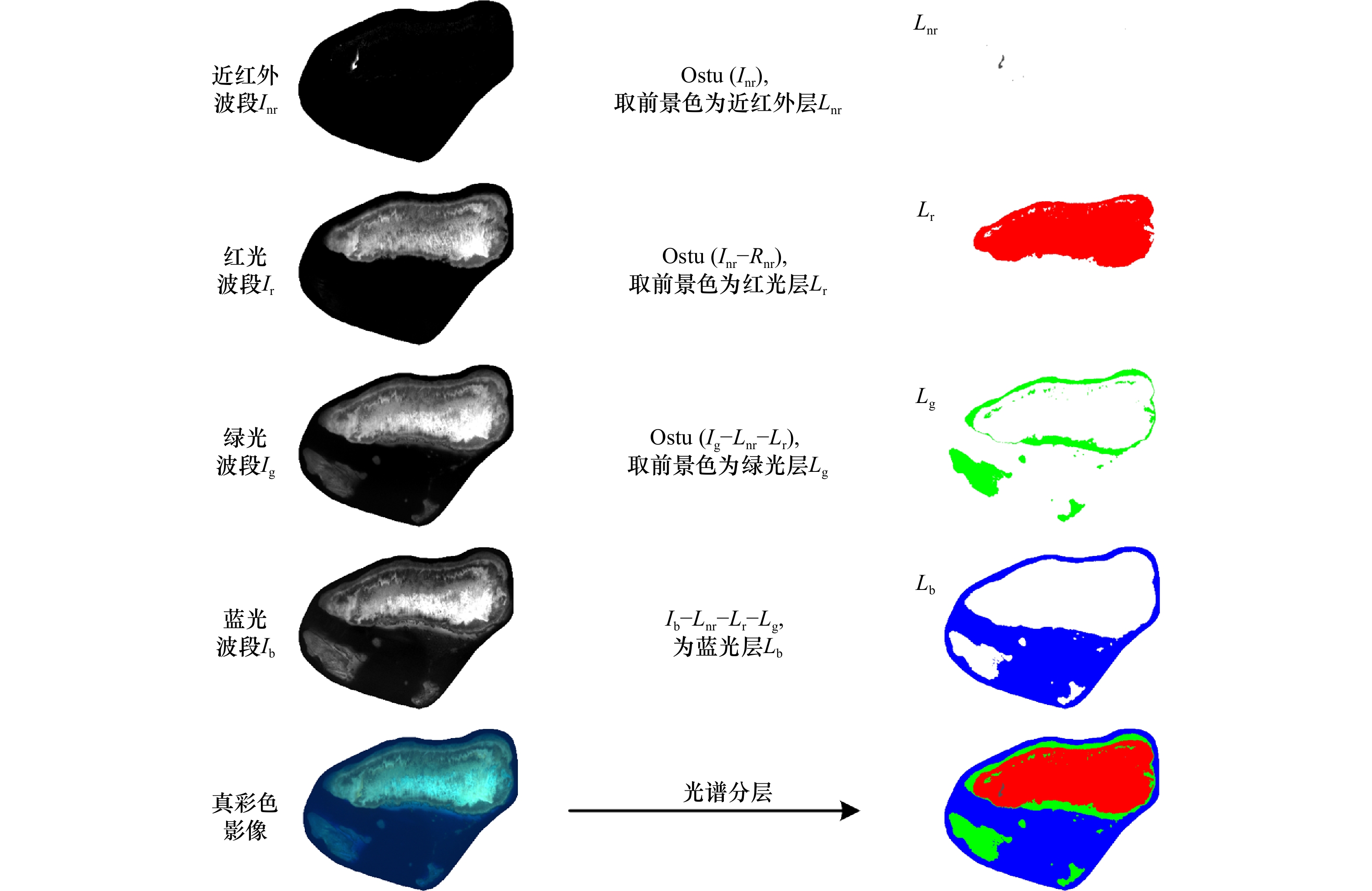
摘要: 卫星水深反演是水深测量的一种重要手段,其中Stumpf比值算法和Lyzenga多项式算法应用广泛并诞生了大量改进算法,但这些算法没有顾及不同光谱的测深极限与适用范围,为此本文提出一种基于光谱分层的水深反演方法。首先,根据红、绿、蓝光谱对水体的穿透能力差异,提出一种基于影像本身的无参数光谱分层策略,提取红光层、绿光层、蓝光层;然后,根据不同光谱层的波段测深性能,分光谱层构建水深反演优化模型,获取浅海水深反演结果。以我国南沙海域长线礁和美属维尔京群岛巴克岛为实验区,本文方法对经典Stumpf比值算法和Lyzenga多项式算法进行改进后,水深均方根误差、平均绝对误差、平均相对误差分别降低了0.41~0.89 m、0.35~0.65 m、4%~19%,尤其在红光层,即水深较浅区域,平均相对误差降低了58%~149%,精度提升明显。因此,改进算法在提高卫星水深反演效果方面具有可行性和有效性。Abstract: Shallow water bathymetry using remote sensing is an important technology in marine geodesy. The Stumpf ratio and Lyzenga polynomial methods, as classic representative algorithms, are widely used and many improved algorithms have been developed. However, these methods do not take into account the bathymetry ability of different spectra. In this study, we propose a bathymetry method based on spectral stratification. Firstly, according to the difference in the penetration ability of red, green and blue spectra to the waterbody, an image-based nonparametric spectral layering strategy is proposed to extract the red, green and blue layers. Then, based on the band bathymetric performance of different spectral layers, we constructed a bathymetric inversion optimization model by spectral layers and further obtained the shallow water bathymetry. The Changxian Reef in the Nansha sea area and Buck Island Reef in U.S. Virgin Islands are selected as test cases to validate the proposed method. Compared with the classical Stumpf ratio and Lyzenga polynomial methods, the root-mean-square error (RMSE), mean absolute error (MAE) and mean relative error (MRE) of the proposed method have decreased by 0.41−0.89 m, 0.35−0.65 m, and 4%−19% respectively. Particularly, the accuracy of the red light layer (i.e., the shallow water depth) is significantly improved, and the MRE is reduced by 58%−149%. Our findings suggest that the proposed bathymetry method based on spectral stratification is feasible and effective in improving the accuracy of the shallow water depth estimation and has good potential for future applications.
-
Key words:
- multispectral /
- shallow water /
- water depth retrieval /
- Sentinel-2 /
- Stumpf method /
- Lyzenga method /
- multispectral bathymetry
-
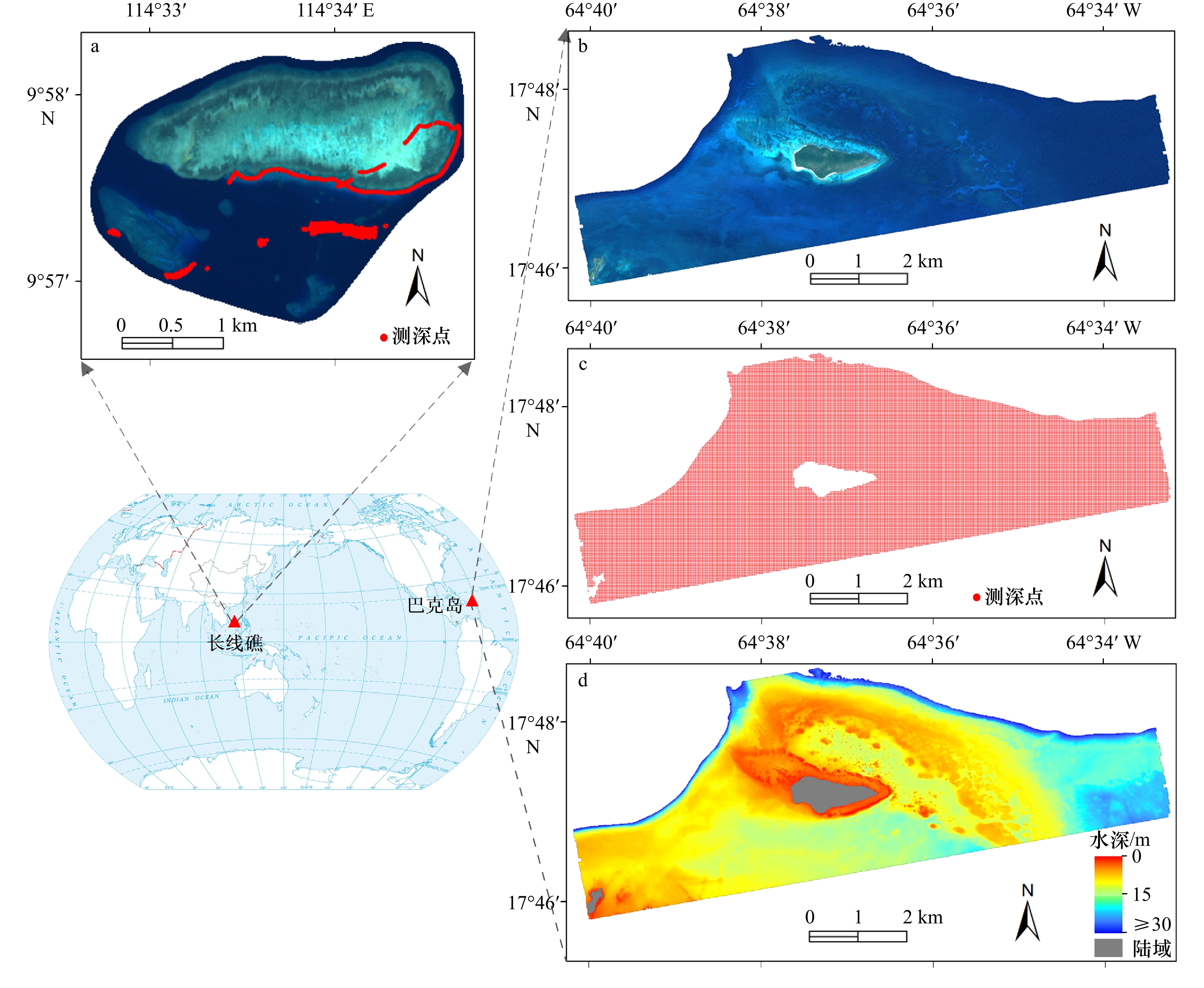
图 1 实验区与水深数据
a. 长线礁遥感影像和声呐测深数据;b. 巴克岛遥感影像;c. 巴克岛激光测深数据;d. 巴克岛水下地形图;左下方世界地图从自然资源部标准地图服务网站下载,审图号为GS(2016)2957号
Fig. 1 Study areas and depth data
a. Remote sensing imagery and sonar bathymetric data for the Changxian Reef; b. remote sensing imagery for the Buck Island Reef; c. airborne laser bathymetric data for the Buck Island Reef; d. underwater topographic map of Buck Island Reef; the world map at bottom left was downloaded from the standard map service website of the Ministry of Natural Resources, the drawing review number is GS (2016) 2957

图 4 长线礁水深反演结果图
a. Stumpf比值算法结果;b. 基于光谱分层的Stumpf比值算法结果;c. Lyzenga多项式算法结果;d. 基于光谱分层的Lyzenga多项式算法结果
Fig. 4 Bathymetric maps of the Changxian Reef produced by inversion
a. Result of Stumpf ratio method; b. result of Stumpf ratio method based on spectral stratification; c. result of Lyzenga polynomial method; d. result of Lyzenga polynomial method based on spectral stratification

图 5 长线礁反演水深与实测水深值误差分布
正值表示反演水深值比实测水深值深
Fig. 5 Distribution of differences obtained by subtracting the measured values from the inversion water depth for the Changxian Reef
Positive value indicates that the inversion water depth is deeper than that of the measured values
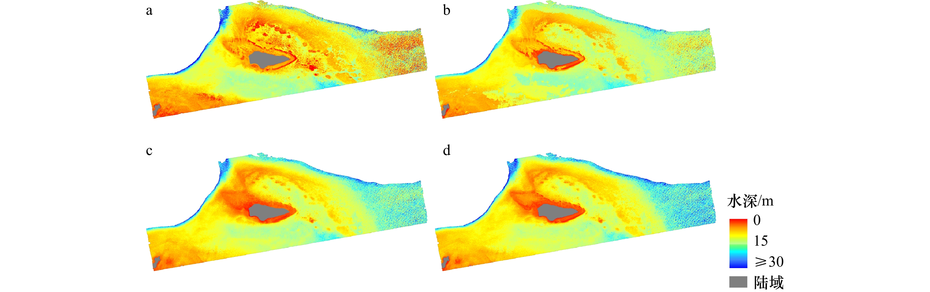
图 6 巴克岛水深反演结果图
a. Stumpf比值算法结果;b. 基于光谱分层的Stumpf比值算法结果;c. Lyzenga多项式算法结果;d. 基于光谱分层的Lyzenga多项式算法结果
Fig. 6 Bathymetric maps of the Buck Island Reef produced by inversion
a. Result of Stumpf ratio method; b. result of Stumpf ratio method based on spectral stratification; c. result of Lyzenga polynomial method; d. result of Lyzenga polynomial method based on spectral stratification

图 7 巴克岛反演水深与实测水深值误差分布图
正值表示反演水深值比实测水深值深
Fig. 7 Distribution of differences obtained by subtracting the measured values from the inversion water depth for the Buck Island Reef
Positive value indicates that the inversion water depth is deeper than that of the measured values
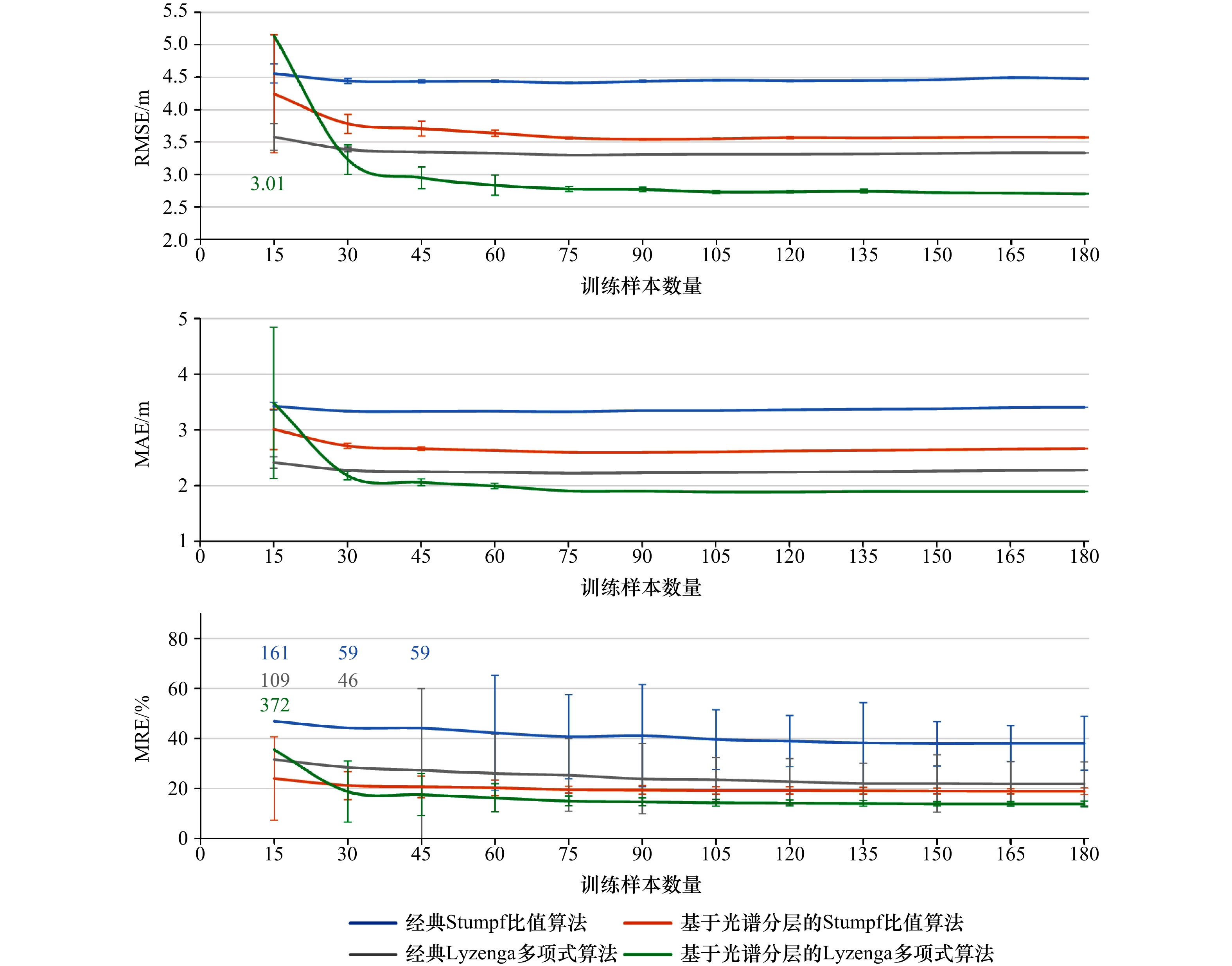
图 8 长线礁实验区训练样本数量对反演精度的影响
Fig. 8 Effects of the number of training samples on the accuracy of bathymetric inversion for the Changxian Reef experimental area
-
[1] Andrejev O, Soomere T, Sokolov A, et al. The role of the spatial resolution of a three-dimensional hydrodynamic model for marine transport risk assessment[J]. Oceanologia, 2011, 53(S1): 309−334. doi: 10.5697/oc.53-1-TI.309 [2] Melet A, Teatini P, Le Cozannet G, et al. Earth observations for monitoring marine coastal hazards and their drivers[J]. Surveys in Geophysics, 2020, 41(6): 1489−1534. doi: 10.1007/s10712-020-09594-5 [3] Sun Minxuan, Yu Linjun, Zhang Ping, et al. Coastal water bathymetry for critical zone management using regression tree models from Gaofen-6 imagery[J]. Ocean & Coastal Management, 2021, 204: 105522. doi: 10.1016/j.ocecoaman.2021.105522 [4] Wang Yanhong, Zhou Xinghua, Li Cong, et al. Bathymetry model based on spectral and spatial multifeatures of remote sensing image[J]. IEEE Geoscience and Remote Sensing Letters, 2020, 17(1): 37−41. doi: 10.1109/LGRS.2019.2915122 [5] 潘信亮, 杨仁辉, 江涛, 等. 基于Bi-LSTM的近岸水体深度反演[J]. 光学学报, 2021, 41(10): 1012003. doi: 10.3788/AOS202141.1012003Pan Xinliang, Yang Renhui, Jiang Tao, et al. Depth inversion of coastal waters based on Bi-LSTM[J]. Acta Optica Sinica, 2021, 41(10): 1012003. doi: 10.3788/AOS202141.1012003 [6] 王浩, 黄文骞, 吴迪, 等. 基于自适应经验半解析模型的无控水深反演方法——以中国南海为例[J]. 光学学报, 2022, 42(6): 0601002. doi: 10.3788/AOS202242.0601002Wang Hao, Huang Wenqian, Wu Di, et al. Bathymetry inversion method based on adaptive empricial semi-analytical model without in situ data—a case study in South China Sea[J]. Acta Optica Sinica, 2022, 42(6): 0601002. doi: 10.3788/AOS202242.0601002 [7] Chu Sensen, Cheng Liang, Ruan Xiaoguang, et al. Technical framework for shallow-water bathymetry with high reliability and no missing data based on time-series sentinel-2 images[J]. IEEE Transactions on Geoscience and Remote Sensing, 2019, 57(11): 8745−8763. doi: 10.1109/TGRS.2019.2922724 [8] 田庆久, 王晶晶, 杜心栋. 江苏近海岸水深遥感研究[J]. 遥感学报, 2007, 11(3): 373−379. doi: 10.11834/jrs.20070351Tian Qingjiu, Wang Jingjing, Du Xindong. Study on water depth extraction from remote sensing imagery in Jiangsu coastal zone[J]. Journal of Remote Sensing, 2007, 11(3): 373−379. doi: 10.11834/jrs.20070351 [9] 黄文骞, 吴迪, 杨杨, 等. 浅海多光谱遥感水深反演技术[J]. 海洋技术, 2013, 32(2): 43−46.Huang Wenqian, Wu Di, Yang Yang, et al. Multi-spectral remote sensing water depth retrieval technique in shallow sea[J]. Ocean Technology, 2013, 32(2): 43−46. [10] 滕惠忠, 熊显名, 李海滨, 等. 遥感水深反演海图修测应用研究[J]. 海洋测绘, 2009, 29(6): 21−25. doi: 10.3969/j.issn.1671-3044.2009.06.006Teng Huizhong, Xiong Xianming, Li Haibin, et al. Research on the use of retrieving sounding by satellite remote sensing in chart surveying[J]. Hydrographic Surveying and Charting, 2009, 29(6): 21−25. doi: 10.3969/j.issn.1671-3044.2009.06.006 [11] Kutser T, Hedley J, Giardino C, et al. Remote sensing of shallow waters—A 50 year retrospective and future directions[J]. Remote Sensing of Environment, 2020, 240: 111619. doi: 10.1016/j.rse.2019.111619 [12] 张源榆, 黄荣永, 余克服, 等. 基于卫星高光谱遥感影像的浅海水深反演方法[J]. 地球信息科学学报, 2020, 22(7): 1567−1577. doi: 10.12082/dqxxkx.2020.190387Zhang Yuanyu, Huang Rongyong, Yu Kefu, et al. Estimation of shallow water depth based on satellite hyperspectral images[J]. Journal of Geo-information Science, 2020, 22(7): 1567−1577. doi: 10.12082/dqxxkx.2020.190387 [13] 马毅, 张杰, 张靖宇, 等. 浅海水深光学遥感研究进展[J]. 海洋科学进展, 2018, 36(3): 331−351. doi: 10.3969/j.issn.1671-6647.2018.03.001Ma Yi, Zhang Jie, Zhang Jingyu, et al. Progress in shallow water depth mapping from optical remote sensing[J]. Advances in Marine Science, 2018, 36(3): 331−351. doi: 10.3969/j.issn.1671-6647.2018.03.001 [14] Lee Z, Carder K L, Mobley C D, et al. Hyperspectral remote sensing for shallow waters: 2. Deriving bottom depths and water properties by optimization[J]. Applied Optics, 1999, 38(18): 3831−3843. doi: 10.1364/AO.38.003831 [15] Huang Rongyong, Yu Kefu, Wang Yinghui, et al. Bathymetry of the coral reefs of Weizhou Island based on multispectral satellite images[J]. Remote Sensing, 2017, 9(7): 750. doi: 10.3390/rs9070750 [16] Wei Jianwei, Wang Menghua, Lee Z, et al. Shallow water bathymetry with multi-spectral satellite ocean color sensors: leveraging temporal variation in image data[J]. Remote Sensing of Environment, 2020, 250: 112035. doi: 10.1016/j.rse.2020.112035 [17] Casal G, Harris P, Monteys X, et al. Understanding satellite-derived bathymetry using Sentinel 2 imagery and spatial prediction models[J]. GIScience & Remote Sensing, 2020, 57(3): 271−286. doi: 10.1080/15481603.2019.1685198 [18] Zhang Xuechun, Ma Yi, Zhang Jingyu. Shallow water bathymetry based on inherent optical properties using high spatial resolution multispectral imagery[J]. Remote Sensing, 2020, 12(18): 3027. doi: 10.3390/rs12183027 [19] Stumpf R P, Holderied K, Sinclair M. Determination of water depth with high-resolution satellite imagery over variable bottom types[J]. Limnology and Oceanography, 2003, 48(1): 547−556. doi: 10.4319/lo.2003.48.1_part_2.0547 [20] Lyzenga D R. Passive remote sensing techniques for mapping water depth and bottom features[J]. Applied Optics, 1978, 17(3): 379−383. doi: 10.1364/ao.17.000379 [21] 陆天启, 吴志芳, 任潇洒, 等. 基于GeoEye-1和WorldView-2遥感数据的浅海水深反演比较研究[J]. 海洋学报, 2022, 44(4): 134−142. doi: 10.12284/hyxb2022082Lu Tianqi, Wu Zhifang, Ren Xiaosa, et al. Comparative study on shallow water depth inversion based on GeoEye-1 and WorldView-2 remote sensing data[J]. Haiyang Xuebao, 2022, 44(4): 134−142. doi: 10.12284/hyxb2022082 [22] Duan Zhixin, Chu Sensen, Cheng Liang, et al. Satellite-derived bathymetry using Landsat-8 and Sentinel-2A images: assessment of atmospheric correction algorithms and depth derivation models in shallow waters[J]. Optics Express, 2022, 30(3): 3238−3261. doi: 10.1364/OE.444557 [23] Zhang Dongfang, Chen Yifu, Le Yuan, et al. Refraction and coordinate correction with the JONSWAP model for ICESat-2 bathymetry[J]. ISPRS Journal of Photogrammetry and Remote Sensing, 2022, 186: 285−300. doi: 10.1016/j.isprsjprs.2022.02.020 [24] Herrmann J, Magruder L A, Markel J, et al. Assessing the ability to quantify bathymetric change over time using solely satellite-based measurements[J]. Remote Sensing, 2022, 14(5): 1232. doi: 10.3390/rs14051232 [25] Pacheco A, Horta J, Loureiro C, et al. Retrieval of nearshore bathymetry from Landsat 8 images: a tool for coastal monitoring in shallow waters[J]. Remote Sensing of Environment, 2015, 159: 102−116. doi: 10.1016/j.rse.2014.12.004 [26] 戚甲伟, 任照宇, 赵金秀, 等. 多光谱遥感影像的两种浅海水深反演模型对比与分析[J]. 海洋学研究, 2020, 38(1): 50−58. doi: 10.3969/j.issn.1001-909X.2020.01.006Qi Jiawei, Ren Zhaoyu, Zhao Jinxiu, et al. Comparison and analysis of two shallow water depth inversion models using multi-spectral remote sensing images[J]. Journal of Marine Sciences, 2020, 38(1): 50−58. doi: 10.3969/j.issn.1001-909X.2020.01.006 [27] Collin A, Hench J L, Pastol Y, et al. High resolution topobathymetry using a Pleiades-1 triplet: Moorea Island in 3D[J]. Remote Sensing of Environment, 2018, 208: 109−119. doi: 10.1016/j.rse.2018.02.015 [28] Leon J X, Cohen T J. An improved bathymetric model for the modern and palaeo Lake Eyre[J]. Geomorphology, 2012, 173−174: 69−79. doi: 10.1016/j.geomorph.2012.05.029 [29] Ma Yue, Xu Nan, Liu Zhen, et al. Satellite-derived bathymetry using the ICESat-2 lidar and Sentinel-2 imagery datasets[J]. Remote Sensing of Environment, 2020, 250: 112047. doi: 10.1016/j.rse.2020.112047 [30] Manessa M D M, Kanno A, Sagawa T, et al. Simulation-based investigation of the generality of Lyzenga’s multispectral bathymetry formula in Case-1 coral reef water[J]. Estuarine, Coastal and Shelf Science, 2018, 200: 81−90. doi: 10.1016/j.ecss.2017.10.014 [31] 田震. 浅海水深多/高光谱遥感模型与水深地形图制作技术研究[D]. 青岛: 山东科技大学, 2015.Tian Zhen. Study on bathymetry inversion models using multispectral or hyperspectral data and bathyorographical mapping technology[D]. Qingdao: Shandong University of Science and Technology, 2015. [32] Dierssen H M, Zimmerman R C, Leathers R A, et al. Ocean color remote sensing of seagrass and bathymetry in the Bahamas Banks by high-resolution airborne imagery[J]. Limnology and Oceanography, 2003, 48(1): 444−455. doi: 10.4319/lo.2003.48.1_part_2.0444 [33] Sánchez-Carnero N, Ojeda-Zujar J, Rodríguez-Pérez D, et al. Assessment of different models for bathymetry calculation using SPOT multispectral images in a high-turbidity area: the mouth of the Guadiana Estuary[J]. International Journal of Remote Sensing, 2014, 35(2): 493−514. doi: 10.1080/01431161.2013.871402 [34] 李丽. 基于WorldView-2数据的西沙群岛遥感水深反演——以赵述岛和南岛为例[J]. 国土资源遥感, 2016, 28(4): 170−175. doi: 10.6046/gtzyyg.2016.04.26Li Li. Remote sensing bathymetric inversion for the Xisha Islands based on WorldView-2 data: a case study of Zhaoshu Island and South Island[J]. Remote Sensing for Natural Resources, 2016, 28(4): 170−175. doi: 10.6046/gtzyyg.2016.04.26 [35] 王燕红, 陈义兰, 周兴华, 等. 基于多项式回归模型的岛礁遥感浅海水深反演[J]. 海洋学报, 2018, 40(3): 121−128. doi: 10.3969/j.issn.0253-4193.2018.03.012Wang Yanhong, Chen Yilan, Zhou Xinghua, et al. Research on reef bathymetry using remote sensing based on polynomial regression model[J]. Haiyang Xuebao, 2018, 40(3): 121−128. doi: 10.3969/j.issn.0253-4193.2018.03.012 [36] 张艳红, 李丽丽, 郭花利, 等. 基于多光谱遥感的扎龙湿地湖泡水深反演研究[J]. 湿地科学, 2016, 14(4): 477−483. doi: 10.13248/j.cnki.wetlandsci.2016.04.005Zhang Yanhong, Li Lili, Guo Huali, et al. Inversion of water depth of lakes in Zhalong Wetlands based on multispectral remote sensing[J]. Wetland Science, 2016, 14(4): 477−483. doi: 10.13248/j.cnki.wetlandsci.2016.04.005 [37] Vojinovic Z, Abebe Y A, Ranasinghe R, et al. A machine learning approach for estimation of shallow water depths from optical satellite images and sonar measurements[J]. Journal of Hydroinformatics, 2013, 15(4): 1408−1424. doi: 10.2166/hydro.2013.234 [38] Misra A, Vojinovic Z, Ramakrishnan B, et al. Shallow water bathymetry mapping using support vector machine (SVM) technique and multispectral imagery[J]. International Journal of Remote Sensing, 2018, 39(13): 4431−4450. doi: 10.1080/01431161.2017.1421796 [39] 党福星, 丁谦. 利用多波段卫星数据进行浅海水深反演方法研究[J]. 海洋通报, 2003, 22(3): 55−60. doi: 10.3969/j.issn.1001-6392.2003.03.008Dang Fuxing, Ding Qian. A technique for extracting water depth information from multispectral scanner data in the South China Sea[J]. Marine Science Bulletin, 2003, 22(3): 55−60. doi: 10.3969/j.issn.1001-6392.2003.03.008 [40] 郭晓雷, 邱振戈, 谭琦, 等. 基于OLI多光谱遥感影像的八所港浅海水深反演[J]. 海洋测绘, 2017, 37(6): 54−57. doi: 10.3969/j.issn.1671-3044.2017.06.014Guo Xiaolei, Qiu Zhen’ge, Tan Qi, et al. Shallow water depth extraction from OLI remote sensing image in Basuo Port[J]. Hydrographic Surveying and Charting, 2017, 37(6): 54−57. doi: 10.3969/j.issn.1671-3044.2017.06.014 [41] Su Haibin, Liu Hongxing, Wang Lei, et al. Geographically adaptive inversion model for improving bathymetric retrieval from satellite multispectral imagery[J]. IEEE Transactions on Geoscience and Remote Sensing, 2014, 52(1): 465−476. doi: 10.1109/TGRS.2013.2241772 [42] Su Haibin, Liu Hongxing, Heyman W D. Automated derivation of bathymetric information from multi-spectral satellite imagery using a non-linear inversion model[J]. Marine Geodesy, 2008, 31(4): 281−298. doi: 10.1080/01490410802466652 [43] Otsu N. A threshold selection method from gray-level histograms[J]. IEEE Transactions on Systems, Man, and Cybernetics, 1979, 9(1): 62−66. doi: 10.1109/TSMC.1979.4310076 -

 下载:
下载:


计量
- 文章访问数: 1499
- HTML全文浏览量: 508
- PDF下载量: 184
- 被引次数: 0
