

An inversion method for joint observation of wind gusts by HY-2B satellite remote sensors
-
摘要: 国内外对海上阵风的研究并不多,且大多集中在阵风预报和应用研究方面,对于海洋阵风数据的获取技术未见文献系统论述。本文利用HY-2B卫星雷达高度计观测的后向散射系数,结合校正微波辐射计观测的亮度温度信息,提出联合反演阵风风速的方法。两个遥感载荷联合反演得到的阵风风速与2019–2021年美国国家浮标数据中心(NDBC)浮标数据进行真实性检验,结果显示:阵风风速均方根误差(RMSE)为0.98 m/s,相关系数为0.82;基于本方法利用国外同类卫星Jason-3得到的阵风风速与2016–2018年NDBC浮标数据的RMSE为0.96 m/s,相关系数为0.88。本文在HY-2B卫星雷达高度计海面风速观测的基础上,纳入同一卫星平台校正微波辐射计的同步观测信息联合实现了海面阵风的观测,数据的比对结果证明文中方法具有较高的观测精度。同时,该方法对于具有相同观测体制的国内外卫星也适用。Abstract: There are few researches on offshore gusts at home and abroad, and most of them focus on gust prediction and application research. There is no systematic discussion on the acquisition technology of wind gust data. Based on the backscattering coefficient observed by HY-2B satellite radar altimeter and the brightness temperature information observed by correction microwave radiometer, a method for retrieving gust wind speed is proposed in this paper. The gust wind speed obtained from the joint inversion of the two remote sensing sensors is verified with the National Data Buoy Center (NDBC) buoy data from 2019 to 2021. The results show that the gust wind speed root mean square error (RMSE) is 0.98 m/s and the correlation coefficient is 0.82. The RMSE of the gust wind speed obtained based on the method using a similar satellite Jason-3 is 0.96 m/s and the correlation coefficient is 0.88. Based on the observation of sea surface wind speed with HY-2B satellite radar altimeter and the synchronous observation information of correction microwave radiometer by satellite platform, the observation of sea surface wind gust is realized jointly. The comparison results of data show that the method in this paper has high observation accuracy. At the same time, this method is also applicable to domestic and foreign satellites with the same observation system. This provides a simple and reliable means of ocean remote sensing technology for the current situation of insufficient observation capacity of offshore wind gust.
-
Key words:
- HY-2B satellite /
- radar altimeter /
- correction microwave radiometer /
- wind gust /
- inversion method
-
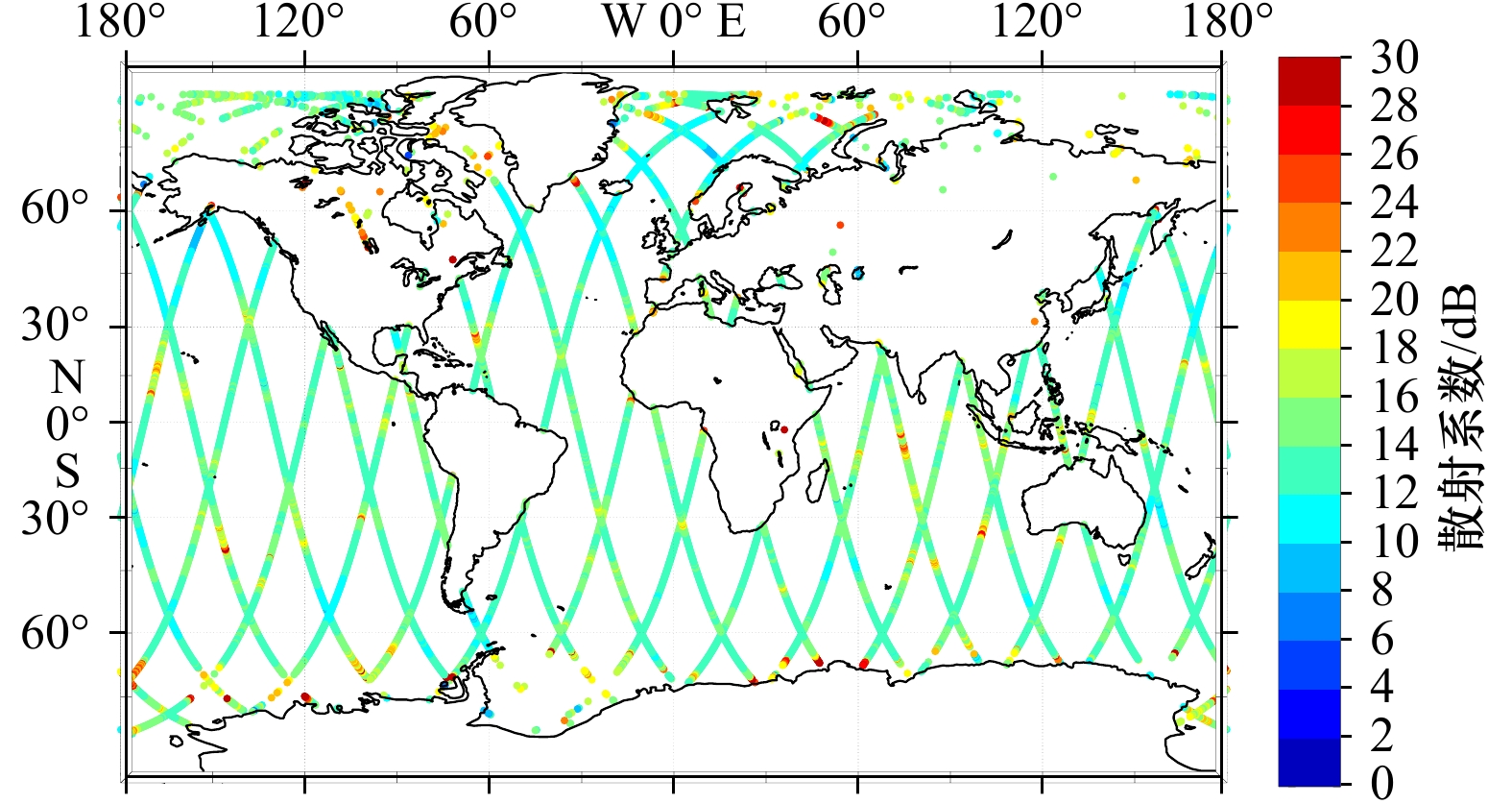
图 1 HY-2B卫星雷达高度计观测的海面后向散射系数示意图
Fig. 1 Backscattering coefficient observed by HY-2B satellite radar altimeter

图 2 HY-2B卫星校正微波辐射计18.7 GHz通道观测亮度温度示意图
Fig. 2 Brightness temperature of 18.7 GHz channel of HY-2B satellite correction radiometer
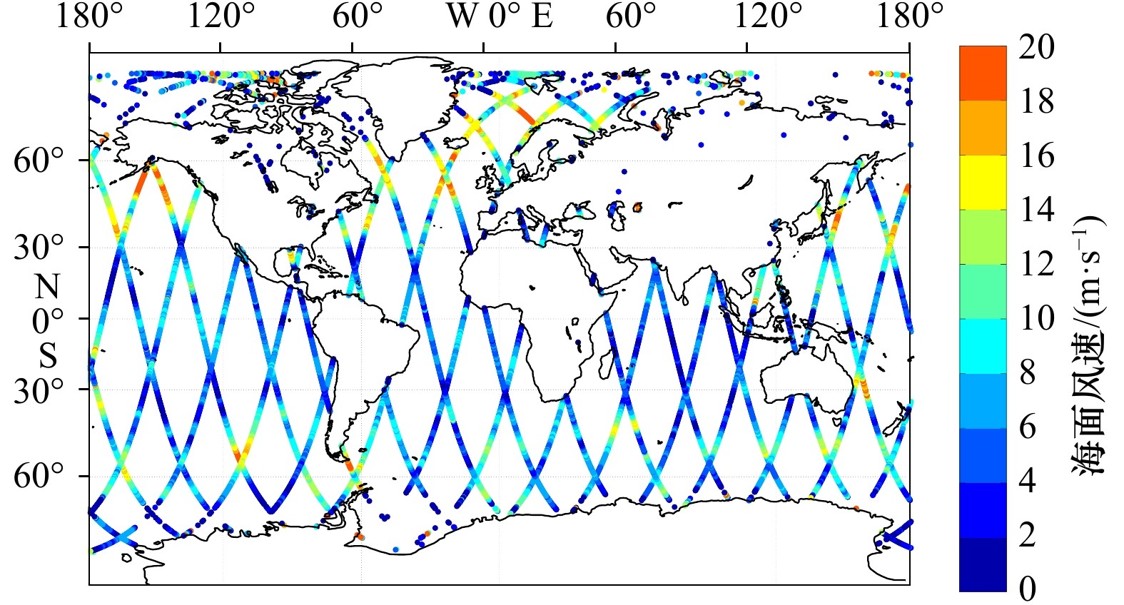
图 4 HY-2B卫星雷达高度计观测海面风速示意图
Fig. 4 Sea surface wind speed observed by HY-2B satellite radar altimeter
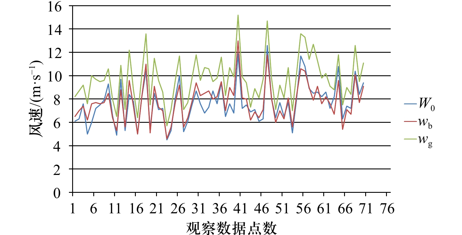
图 5 HY-2B卫星的海面风速(W0)和NDBC浮标观测到的对应海面风速(wb)及阵风风速(wg)
Fig. 5 HY-2B satellite sea surface wind speed (W0) and the corresponding sea surface wind speed (wb) and wind gusts (wg) observed by NDBC buoy

图 6 HY-2B卫星的海面风速(W0)与NDBC浮标风速(wb)以及阵风风速(wg)之间的绝对误差
Fig. 6 Absolute error between HY-2B satellite wind speed (W0) and NDBC buoy wind speed (wb) and wind gusts (wg)
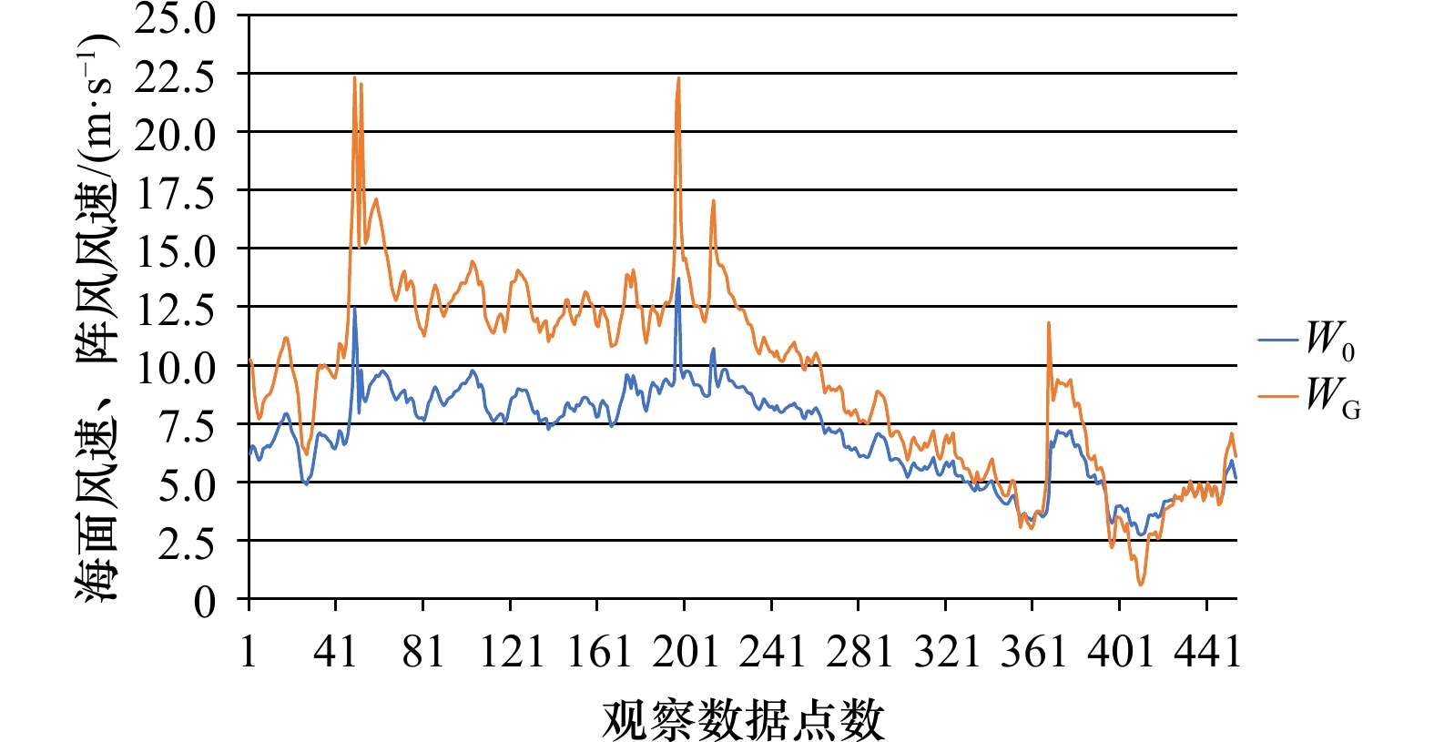
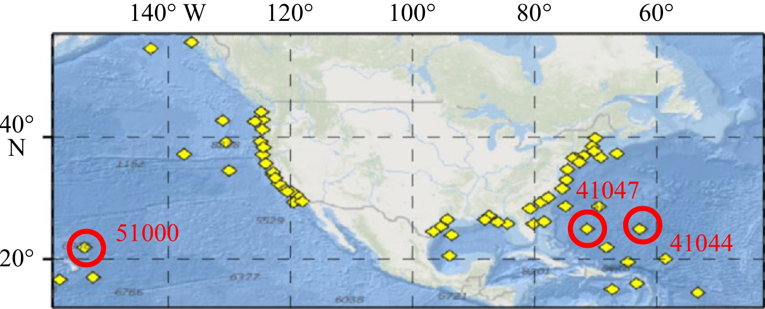
图 7 浮标41044附近的HY-2B卫星观测海面风速(W0)和阵风风速(WG)
Fig. 7 Wind speed (W0) and wind gust (WG) observed by HY-2B satellite near Buoy 41044

图 8 浮标51000附近的HY-2B卫星观测海面风速(W0)和阵风风速(WG)
Fig. 8 Wind speed (W0) and wind gust (WG) observed by HY-2B satellite near Buoy 51000
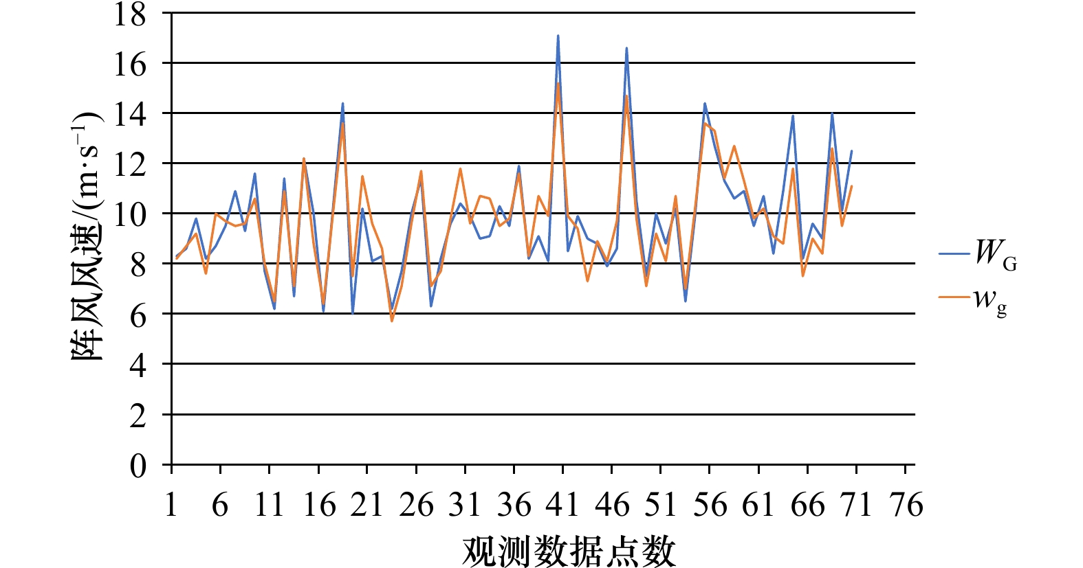
图 9 HY-2B 卫星获取的阵风风速(WG)与NDBC浮标观测到的阵风风速(wg)
Fig. 9 HY-2B satellite observed wind gust (WG) and wind gusts (wg) observed by NDBC buoy
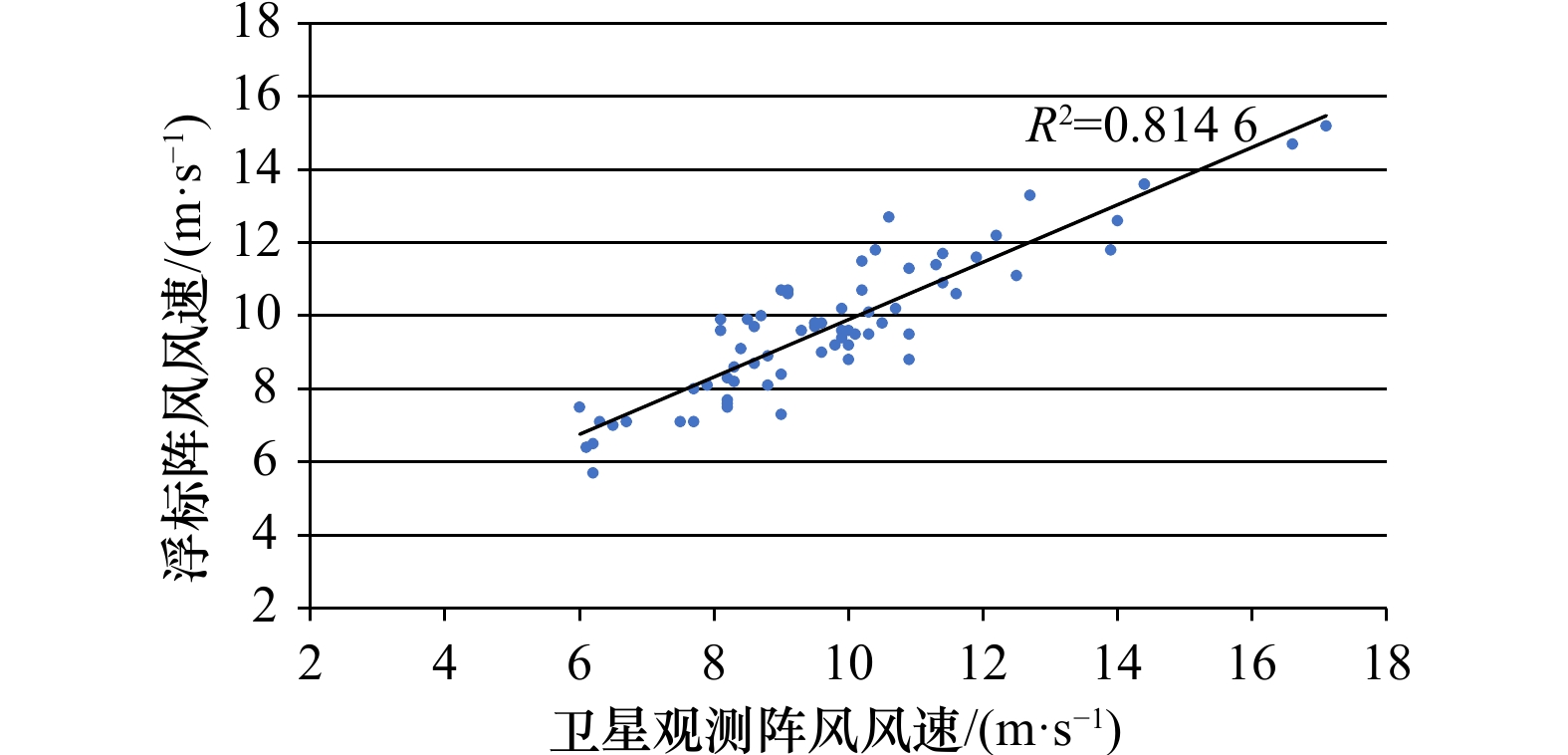
图 10 HY-2B卫星与2019–2021年浮标阵风数据比对散点图
Fig. 10 Scatter diagram of comparison between HY-2B satellite wind gust and buoy wind gust from 2019 to 2021

图 11 卫星的风速和阵风风速与浮标观测结果之间的绝对误差
Fig. 11 Absolute error between satellite wind speed and gust wind speed and buoy observations
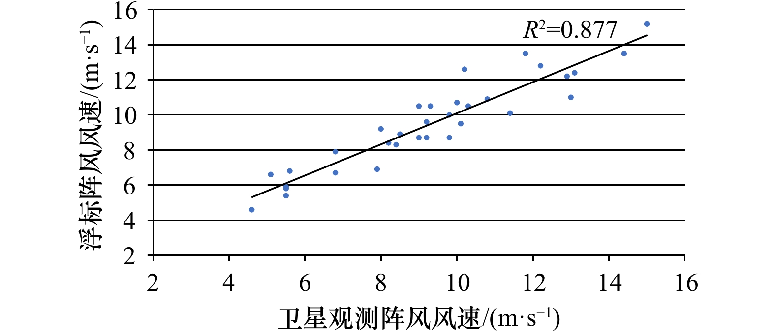
图 12 2016−2018年Jason-3卫星与浮标阵风的对比散点图
Fig. 12 Scatter diagram of comparison between Jason-3 satellite and buoy wind gust from 2016 to 2018
表 1 Gourrion模型参数
Tab. 1 Gourrion model parameters
参数 a b σ0 –0.343 36 0.069 09 SWH 0.087 25 0.063 74 U10 0.1 0.028 44  下载: 导出CSV
表 2 Gourrion模型参数
Tab. 2 Gourrion model parameters
参数 矩阵元素 ${ \overline {{\boldsymbol{W}}_{x}} }$ –33.950 62 –11.033 94 –3.934 28 –0.058 34 $ {\overline {{\boldsymbol{W}}_{y}} }$ 0.540 12 10.404 81 ${ \overline {{\boldsymbol{B}}_{x}} }$ 18.063 78 –0.372 28 ${ \overline {{\boldsymbol{B}}_{y}} }$ –2.283 87 … ${ {\boldsymbol{P} } }$ $ { { {a} }_{\sigma^0} + b_{\sigma^0}\sigma ^0}$ aSWH + bSWHSWH
下载: 导出CSV
表 3 HY-2B卫星与41044浮标2019年数据比对结果
Tab. 3 Comparison results between HY-2B satellite and Buoy 41044 in 2019
序号 日期 观测源 时间 观测位置 阵风
风速/
(m·s−1)绝对
误差/
(m·s−1)观测点
距离/
km1 4月4日 卫星 21:43 21.38°N,59.15°W 8.3 0.1 60 41044 21:40 21.59°N,58.63°W 8.2 2 6月27日 卫星 21:43 21.38°N,59.15°W 8.6 0.1 59 41044 21:40 21.59°N,58.63°W 8.7 3 7月25日 卫星 21:43 21.60°N,59.21°W 9.8 0.6 60 41044 21:40 21.59°N,58.63°W 9.2 4 8月22日 卫星 21:43 21.3°N,59.14°W 5.7 0.9 60 41044 21:40 21.59°N,58.63°W 7.6 5 9月19日 卫星 21:44 21.45°N,59.18°W 8.7 1.3 59 41044 21:40 21.59°N,58.63°W 10.0 6 12月12日 卫星 21:44 21.49°N,59.21°W 9.5 0.2 61 41044 21:40 21.59°N,58.63°W 9.7 7 12月26日 卫星 21:44 21.5°N,59.21°W 10.9 1.4 61 41044 21:40 21.59°N,58.63°W 9.5
下载: 导出CSV
表 4 HY-2B卫星与41044浮标2020年数据比对结果
Tab. 4 Comparison results between HY-2B satellite and Buoy 41044 in 2020
序号 日期 观测源 时间 观测位置 阵风
风速/
(m·s−1)绝对
误差/
(m·s−1)观测点
距离/
km1 1月9日 卫星 21:44 21.42°N,59.23°W 9.3 0.3 61 41044 21:40 21.59°N,58.63°W 9.6 2 2月6日 卫星 21:44 21.51°N,59.21°W 11.6 1.0 61 41044 21:40 21.59°N,58.63°W 10.6 3 4月16日 卫星 21:44 21.62°N,59.23°W 7.7 0.3 60 41044 21:40 21.58°N,58.63°W 8.0 4 5月28日 卫星 21:45 21.56°N,59.20°W 6.2 0.3 59 41044 21:50 21.58°N,58.63°W 6.5 5 7月23日 卫星 21:45 21.62°N,59.23°W 11.4 0.5 58 41044 21:40 21.59°N,58.63°W 10.9 6 9月3日 卫星 21:44 21.62°N,59.23°W 6.7 0.4 58 41044 21:40 21.59°N,58.63°W 7.1 7 9月17日 卫星 21:44 21.45°N,59.18°W 12.2 0 59 41044 21:40 21.59°N,58.63°W 12.2 8 10月1日 卫星 21:44 21.58°N,59.22°W 10.0 1.2 61 41044 21:40 21.59°N,58.63°W 8.8 9 10月15日 卫星 21:44 21.62°N,59.23°W 6.1 0.3 59 41044 21:40 21.59°N,58.63°W 6.4 10 11月12日 卫星 21:44 21.51°N,59.19°W 10.3 0.2 58 41044 21:40 21.59°N,58.63°W 10.1 11 12月24日 卫星 21:44 21.62°N,59.23°W 14.4 0.8 58 41044 21:40 21.59°N,58.63°W 13.6
下载: 导出CSV
表 5 HY-2B卫星与41044浮标2021年数据比对结果
Tab. 5 Comparison results between HY-2B satellite and Buoy 41044 in 2021
序号 日期 观测源 时间 观测位置 阵风
风速/
(m·s−1)绝对
误差/
(m·s−1)观测点
距离/
km1 2月4日 卫星 21:46 21.56°N,59.21°W 6.0 1.5 60 41044 21:40 21.59°N,58.63°W 7.5 2 2月18日 卫星 21:44 21.47°N,59.19°W 10.2 1.3 59 41044 21:40 21.59°N,58.63°W 11.5 3 3月18日 卫星 21:44 21.47°N,59.19°W 8.1 1.5 60 41044 21:40 21.59°N,58.63°W 9.6 4 5月13日 卫星 21:44 21.60°N,59.21°W 8.3 0.3 60 41044 21:40 21.59°N,58.63°W 8.6 5 6月24日 卫星 21:46 21.59°N,59.21°W 6.2 0.5 60 41044 21:50 21.59°N,58.63°W 5.7 6 6月10日 卫星 21:46 21.61°N,59.21°W 7.7 0.6 60 41044 21:50 21.59°N,58.63°W 7.1 7 7月8日 卫星 21:46 21.60°N,59.21°W 10.0 0.4 60 41044 21:50 21.59°N,58.63°W 9.6 8 8月19日 卫星 21:46 21.59°N,59.21°W 11.4 0.3 61 41044 21:50 21.59°N,58.63°W 11.7 9 9月2日 卫星 21:46 21.59°N,59.21°W 6.3 0.8 60 41044 21:50 21.59°N,58.63°W 7.1 10 9月16日 卫星 21:47 21.59°N,59.21°W 8.2 0.5 58 41044 21:50 21.59°N,58.63°W 7.7 11 12月9日 卫星 21:47 21.59°N,59.21°W 9.6 0.2 60 41044 21:50 21.59°N,58.63°W 9.8
下载: 导出CSV
表 6 HY-2B卫星与51000浮标2019年数据比对结果
Tab. 6 Comparison results between HY-2B satellite and Buoy 51000 in 2019
序号 日期 观测源 时间 观测位置 阵风
风速/
(m·s−1)绝对
误差/
(m·s−1)观测点
距离/
km1 4月21日 卫星 16:31 23.54°N,153.47°W 10.4 1.4 33 51000 16:50 23.528°N,153.792°W 11.8 2 6月2日 卫星 16:31 23.51°N,153.48°W 9.9 0.4 32 51000 16:50 23.528°N,153.792°W 9.6 3 6月16日 卫星 16:31 23.50°N,153.45°W 9.0 1.7 34 51000 16:50 23.528°N,153.792°W 10.7 4 6月30日 卫星 16:31 23.34°N,153.53°W 9.1 1.5 34 51000 16:50 23.528°N,153.792°W 10.6 5 8月25日 卫星 16:31 23.53°N, 153.48° W 10.3 0.8 32 51000 16:50 23.528°N,153.792°W 9.5 6 9月8日 卫星 16:31 23.50°N,153.49°W 9.5 0.3 32 51000 16:50 23.528°N,153.792°W 9.8 7 9月22日 卫星 16:31 23.52°N,153.49°W 11.9 0.3 32 51000 16:50 23.528°N,153.792°W 11.6 8 11月3日 卫星 16:32 23.53°N,153.49°W 8.2 0.1 32 51000 16:50 23.528°N,153.792°W 8.3 9 12月1日 卫星 16:31 23.55°N,153.49°W 9.1 1.6 31 51000 16:50 23.528°N,153.792°W 10.7 10 12月15日 卫星 16:31 23.54°N,153.49°W 8.1 1.8 31 51000 16:50 23.528°N,153.792°W 9.9 11 12月29日 卫星 16:31 23.53°N,153.47°W 9.0 0.9 32 51000 16:50 23.528°N,153.792°W 9.9
下载: 导出CSV
表 7 HY-2B卫星与51000浮标2020年数据比对结果
Tab. 7 Comparison results between HY-2B satellite and Buoy 51000 in 2020
序号 日期 观测源 时间 观测位置 阵风
风速/
(m·s−1)绝对
误差/
(m·s−1)观测点
距离/
km1 1月12日 卫星 16:31 23.57°N,153.49°W 17.1 1.9 30 51000 16:50 23.528°N,153.792°W 15.2 2 2月23日 卫星 16:31 23.54°N,153.49°W 8.5 1.4 31 51000 16:50 23.528°N,153.792°W 9.9 3 3月22日 卫星 16:31 23.53°N,153.48°W 9.9 0.1 32 51000 16:50 23.528°N,153.792°W 9.4 4 5月3日 卫星 16:31 23.45°N,153.49°W 9.0 1.7 32 51000 16:50 23.528°N,153.792°W 7.3 5 5月17日 卫星 16:33 23.55°N,153.47°W 8.8 0.1 33 51000 16:30 23.528°N,153.792°W 8.9 6 6月14日 卫星 16:33 23.54°N,153.47°W 7.9 0.2 33 51000 16:30 23.528°N,153.792°W 8.1 7 7月12日 卫星 16:33 23.50°N,153.48°W 8.6 1.1 32 51000 16:30 23.528°N,153.792°W 9.7 8 7月26日 卫星 16:33 23.50°N,153.48°W 16.6 1.9 32 51000 16:40 23.528°N,153.792°W 14.7 9 8月9日 卫星 16:31 23.55°N,153.47°W 10.5 0.7 33 51000 16:30 23.528°N,153.792°W 9.8 10 8月23日 卫星 16:31 23.55°N,153.48°W 7.5 0.4 32 51000 16:30 23.528°N,153.792°W 7.1 11 9月6日 卫星 16:31 23.51°N,153.49°W 10.0 0.8 31 51000 16:30 23.528°N,153.792°W 9.2 12 9月20日 卫星 16:31 23.52°N,153.49°W 8.8 0.7 31 51000 16:30 23.528°N,153.792°W 8.1 13 10月18日 卫星 16:31 23.55°N,53.48°W 10.2 0.5 33 51000 16:30 23.528°N,153.792°W 10.7 14 11月15日 卫星 16:31 23.56°N,153.47°W 6.5 0.5 32 51000 16:30 23.528°N,153.792°W 7.0 15 11月29日 卫星 16:31 23.52°N,153.48°W 9.9 0.3 32 51000 16:30 23.528°N,153.792°W 10.2 16 12月27日 卫星 16:31 23.54°N,153.47°W 14.4 0.8 33 51000 16:30 23.528°N,153.792°W 13.6
下载: 导出CSV
表 8 HY-2B卫星与51000浮标2021年数据比对结果
Tab. 8 Comparison results between HY-2B satellite and Buoy 51000 in 2021
序号 日期 观测源 时间 观测位置 阵风
风速/
(m·s−1)绝对
误差/
(m·s−1)观测点
距离/
km1 1月24日 卫星 16:31 23.54°N,153.47°W 12.7 0.6 32 51000 16:30 23.528°N,153.792°W 13.3 2 2月26日 卫星 16:31 23.53°N,153.49°W 11.3 0.1 31 51000 16:30 23.528°N,153.792°W 11.4 3 3月7日 卫星 16:34 23.6°N,153.47°W 10.6 2.1 34 51000 16:30 23.528°N,153.792°W 12.7 4 3月21日 卫星 16:31 23.55°N,153.49°W 10.9 0.4 31 51000 16:30 23.528°N,153.792°W 11.3 5 5月2日 卫星 16:31 23.52°N,153.48°W 9.5 0.3 32 51000 16:30 23.528°N,153.792°W 9.8 6 5月16日 卫星 16:31 23.50°N, 153.48° W 10.7 0.5 32 51000 16:30 23.528°N,153.792°W 10.2 7 7月11日 卫星 16:35 23.55°N,153.47°W 8.4 0.7 32 51000 16:30 23.528°N,153.792°W 9.1 8 7月25日 卫星 16:35 23.51°N,153.50°W 10.9 2.1 30 51000 16:30 23.528°N,153.792°W 8.8 9 8月22日 卫星 16:35 23.6°N,153.5°W 13.9 2.1 36 51000 16:30 23.528°N,153.792°W 11.8 10 9月5日 卫星 16:35 23.55°N,153.47°W 8.2 0.7 33 51000 16:30 23.528°N,153.792°W 7.5 11 9月19日 卫星 16:35 23.56°N,153.44°W 9.6 0.6 36 51000 16:30 23.528°N,153.792°W 9.0 12 10月3日 卫星 16:35 23.56°N,153.44°W 9.0 0.6 36 51000 16:30 23.528°N,153.792°W 8.4 13 11月28日 卫星 16:35 23.55°N,153.47°W 14.0 1.4 33 51000 16:30 23.528°N,153.792°W 12.6 14 12月12日 卫星 16:31 23.53°N,153.48°W 10.1 0.6 32 51000 16:50 23.528°N,153.792°W 9.5 15 12月26日 卫星 16:31 23.53°N,153.48°W 12.5 1.4 32 51000 16:50 23.528°N,153.792°W 11.1
下载: 导出CSV
表 9 Jason-3 卫星与41047浮标数据比对结果
Tab. 9 Comparison results between Jason-3 satellite and Buoy 41047
序号 日期 观测源 时间 观测位置 阵风风速/(m·s−1) 绝对误差/(m·s−1) 观测点距离/km 1 2016年4月15日 卫星 11:11 27.22°N,70.72°W 6.9 1.0 79 41047 10:50 27.46°N,71.47°W 7.9 2 2016年4月25日 卫星 09:10 27.20°N,70.71°W 10.5 1.5 80 41047 08:50 27.46°N,71.47°W 9.0 3 2016年6月4日 卫星 01:04 27.24°N,70.68°W 5.9 0.4 82 41047 01:10 27.46°N,71.47°W 5.5 4 2016年6月23日 卫星 21:01 27.22°N,70.70°W 5.4 0.1 81 41047 21:00 27.46°N,71.47°W 5.5 5 2016年7月23日 卫星 14:57 27.22°N,70.71°W 4.6 0 80 41047 15:00 27.46°N,71.47°W 4.6 6 2016年9月1日 卫星 06:51 27.26°N,71.69°W 7.9 1.1 80 41047 07:00 27.46°N,71.47°W 6.8 7 2016年10月1日 卫星 00:46 27.20°N,70.70°W 8.7 0.3 81 41047 00:50 27.46°N,71.47°W 9.0 8 2016年10月10日 卫星 22:45 27.21°N,70.71°W 15.2 0.2 80 41047 22:50 27.46°N,71.47°W 15.0 9 2016年10月20日 卫星 20:43 27.21°N,70.71°W 12.8 0.6 80 41047 20:50 27.46°N,71.47°W 12.2 10 2016年10月30日 卫星 18:42 27.22°N,70.71°W 8.7 1.1 80 41047 18:50 27.46°N,71.47°W 9.8 11 2016年11月29日 卫星 12:38 27.24°N,70.69°W 9.6 0.4 81 41047 12:50 27.46°N,71.47°W 9.2 12 2016年12月19日 卫星 08:35 27.21°N,70.70°W 8.7 0.5 81 41047 08:40 27.46°N,71.47°W 9.2 13 2017年4月7日 卫星 10:18 27.21°N,70.70°W 10.9 0.1 81 41047 10:20 27.46°N,71.47°W 10.8 14 2017年5月17日 卫星 04:14 27.22°N,70.70°W 6.6 1.5 81 41047 04:20 27.46°N,71.47°W 5.1 15 2017年10月2日 卫星 21:52 27.21°N,70.71°W 12.4 0.7 80 41047 22:00 27.46°N,71.47°W 13.1 16 2017年10月22日 卫星 17:49 27.21°N,70.71°W 10.7 0.7 80 41047 17:50 27.46°N,71.47°W 10.0 17 2017年11月1日 卫星 15:47 27.21°N,70.71°W 9.5 0.6 80 41047 15:50 27.46°N,71.47°W 10.1 18 2017年11月11日 卫星 13:46 27.24°N,70.69°W 10.1 1.3 81 41047 13:50 27.46°N,71.47°W 11.4 19 2017年11月21日 卫星 11:45 27.23°N,70.70°W 13.5 0.9 80 41047 11:50 27.46°N,71.47°W 14.4 20 2017年12月1日 卫星 09:43 27.23°N,70.70°W 9.2 1.2 80 41047 09:50 27.46°N,71.47°W 8.0 21 2017年12月11日 卫星 07:42 27.22°N,70.70°W 12.6 2.4 81 41047 07:40 27.46°N,71.47°W 10.2 22 2018年1月10日 卫星 01:37 27.28°N,70.67°W 13.5 1.7 81 41047 01:50 27.46°N,71.47°W 11.8 23 2018年2月28日 卫星 15:30 27.21°N,70.71°W 11.0 2.0 80 41047 15:40 27.46°N,71.47°W 13.0 24 2018年3月20日 卫星 11:27 27.22°N,70.70°W 8.3 0.1 81 41047 11:30 27.46°N,71.47°W 8.4 25 2018年4月29日 卫星 03:21 27.21°N,70.70°W 8.4 0.2 81 41047 03:30 27.46°N,71.47°W 8.2 26 2018年5月9日 卫星 01:19 27.23°N,70.69°W 10.5 1.5 81 41047 01:20 27.46°N,71.47°W 9.3 27 2018年5月18日 卫星 23:18 27.24°N,70.69°W 10.5 0.2 81 41047 23:30 27.46°N,71.47°W 10.3 28 2018年5月28日 卫星 21:17 27.22°N,70.70°W 8.9 0.4 81 41047 21:20 27.46°N,71.47°W 8.5 29 2018年7月17日 卫星 11:09 27.22°N,70.70°W 6.7 0.1 81 41047 11:20 27.46°N,71.47°W 6.8 30 2018年7月27日 卫星 09:08 27.27°N,70.68°W 5.8 0.3 81 41047 09:20 27.46°N,71.47°W 5.5 31 2018年11月13日 卫星 10:51 27.21°N,70.71°W 10.0 0.2 80 41047 11:00 27.46°N,71.47°W 9.8 32 2018年11月23日 卫星 08:50 27.28°N,70.67°W 12.2 0.7 80 41047 09:00 27.46°N,71.47°W 12.9 33 2018年12月3日 卫星 06:48 27.27°N,70.68°W 6.8 1.2 81 41047 06:50 27.46°N,71.47°W 5.6
下载: 导出CSV
-
[1] 张云彩, 姚美旺, 王敏声, 等. 阵风及其谱模拟[J]. 海洋工程, 1996, 14(2): 20−27. doi: 10.16483/j.issn.1005-9865.1996.02.004Zhang Yuncai, Yao Meiwang, Wang Minsheng, et al. Gust simulation[J]. The Ocean Engineering, 1996, 14(2): 20−27. doi: 10.16483/j.issn.1005-9865.1996.02.004 [2] 周福, 蒋璐璐, 涂小萍, 等. 浙江省几种灾害性大风近地面阵风系数特征[J]. 应用气象学报, 2017, 28(1): 119−128. doi: 10.11898/1001-7313.20170111Zhou Fu, Jiang Lulu, Tu Xiaoping, et al. Near-surface gust factor characteristics in several disastrous winds over Zhejiang Province[J]. Journal of Applied Meteorological Science, 2017, 28(1): 119−128. doi: 10.11898/1001-7313.20170111 [3] 胡波, 杜惠良, 俞燎霓, 等. 一种经验相似方法在沿海海岛阵风预报中的应用[J]. 海洋预报, 2014, 31(3): 37−44. doi: 10.11737/j.issn.1003-0239.2014.03.005Hu Bo, Du Huiliang, Yu Liaoni, et al. Application of an empirical similar statistic downscaling method in extreme wind forecast[J]. Marine Forecasts, 2014, 31(3): 37−44. doi: 10.11737/j.issn.1003-0239.2014.03.005 [4] 魏晓琳, 王德立, 贺佳佳, 等. 深圳沿海地区阵风系数的特征[J]. 广东气象, 2016, 38(5): 33−36, 41. doi: 10.3969/j.issn.1007-6190.2016.05.008Wei Xiaolin, Wang Deli, He Jiajia, et al. Characteristics analysis on gust factors over coastal areas in Shenzhen[J]. Guangdong Meteorology, 2016, 38(5): 33−36, 41. doi: 10.3969/j.issn.1007-6190.2016.05.008 [5] Giglio D, Gille S T, Subramanian A C, et al. The role of wind gusts in upper ocean diurnal variability[J]. Journal of Geophysical Research: Oceans, 2017, 122(9): 7751−7764. doi: 10.1002/2017JC012794 [6] 万夫敬, 孙继松, 孙敏, 等. 山东半岛海风锋在一次飑线系统演变过程中的作用[J]. 气象学报, 2021, 79(5): 717−731. doi: 10.11676/qxxb2021.056Wan Fujing, Sun Jisong, Sun Min, et al. Impacts of sea breeze front over Shandong Peninsula on the evolution of a squall line[J]. Acta Meteorologica Sinica, 2021, 79(5): 717−731. doi: 10.11676/qxxb2021.056 [7] 林明森, 张有广. 我国海洋动力环境卫星应用现状及发展展望[J]. 卫星应用, 2018(5): 19−23. doi: 10.3969/j.issn.1674-9030.2018.05.006Lin Mingsen, Zhang Youguang. Application and development of Chinese ocean dynamic environment satellites[J]. Satellite Application, 2018(5): 19−23. doi: 10.3969/j.issn.1674-9030.2018.05.006 [8] Brown G, Stanley H, Roy N. The wind-speed measurement capability of spaceborne radar altimeters[J]. IEEE Journal of Oceanic Engineering, 1981, 6(2): 59−63. doi: 10.1109/JOE.1981.1145484 [9] Chelton D B, McCabe P J. A review of satellite altimeter measurement of sea surface wind speed: With a proposed new algorithm[J]. Journal of Geophysical Research: Oceans, 1985, 90(C3): 4707−4720. doi: 10.1029/JC090iC03p04707 [10] Chelton D B, Wentz F J. Further development of an improved altimeter wind speed algorithm[J]. Journal of Geophysical Research: Oceans, 1986, 91(C12): 14250−14260. doi: 10.1029/JC091iC12p14250 [11] Witter D L, Chelton D B. A Geosat altimeter wind speed algorithm and a method for altimeter wind speed algorithm development[J]. Journal of Geophysical Research: Oceans, 1991, 96(C5): 8853−8860. doi: 10.1029/91JC00414 [12] Lefevre J M, Barckicke J, Ménard Y. A significant wave height dependent function for TOPEX/POSEIDON wind speed retrieval[J]. Journal of Geophysical Research: Oceans, 1994, 99(C12): 25035−25049. doi: 10.1029/94JC01958 [13] Gourrion J, Vandemark D, Bailey S, et al. A two-parameter wind speed algorithm for Ku-band altimeters[J]. Journal of Atmospheric and Oceanic Technology, 2002, 19(12): 2030−2048. doi: 10.1175/1520-0426(2002)019<2030:ATPWSA>2.0.CO;2 [14] 蒋兴伟. 海洋动力环境卫星基础理论与工程应用[M]. 北京: 海洋出版社, 2014.Jiang Xingwei. The Based Theory and Engineering Application about Ocean Dynamic Environment Satellite[M]. Beijing: China Ocean Press, 2014. [15] Dumont J P, Rosmorduc V, Carrere L, et al. Jason-3 products handbook[R]. Paris: CNES, 2016. [16] 王振占, 张德海, 赵谨, 等. HY-2A卫星大气校正微波辐射计在轨数据定标和检验研究[J]. 中国工程科学, 2013, 15(7): 44−52, 61. doi: 10.3969/j.issn.1009-1742.2013.07.007Wang Zhenzhan, Zhang Dehai, Zhao Jin, et al. In-orbit calibration and validation of atmospheric correction microwave radiometer on HY-2A satellite[J]. Engineering Science, 2013, 15(7): 44−52, 61. doi: 10.3969/j.issn.1009-1742.2013.07.007 [17] 海洋二号B卫星在轨测试报告[R]. 北京: 国家卫星海洋应用中心, 2019: 66-68.Haiyang-2B satellite in-orbit test report[R]. Beijing: National Satellite Ocean Application Service, 2019: 66−68. -

计量
- 文章访问数: 842
- HTML全文浏览量: 384
- PDF下载量: 44
- 被引次数: 0
