

Sandy coastline fine extraction and correction method based on high resolution image
-
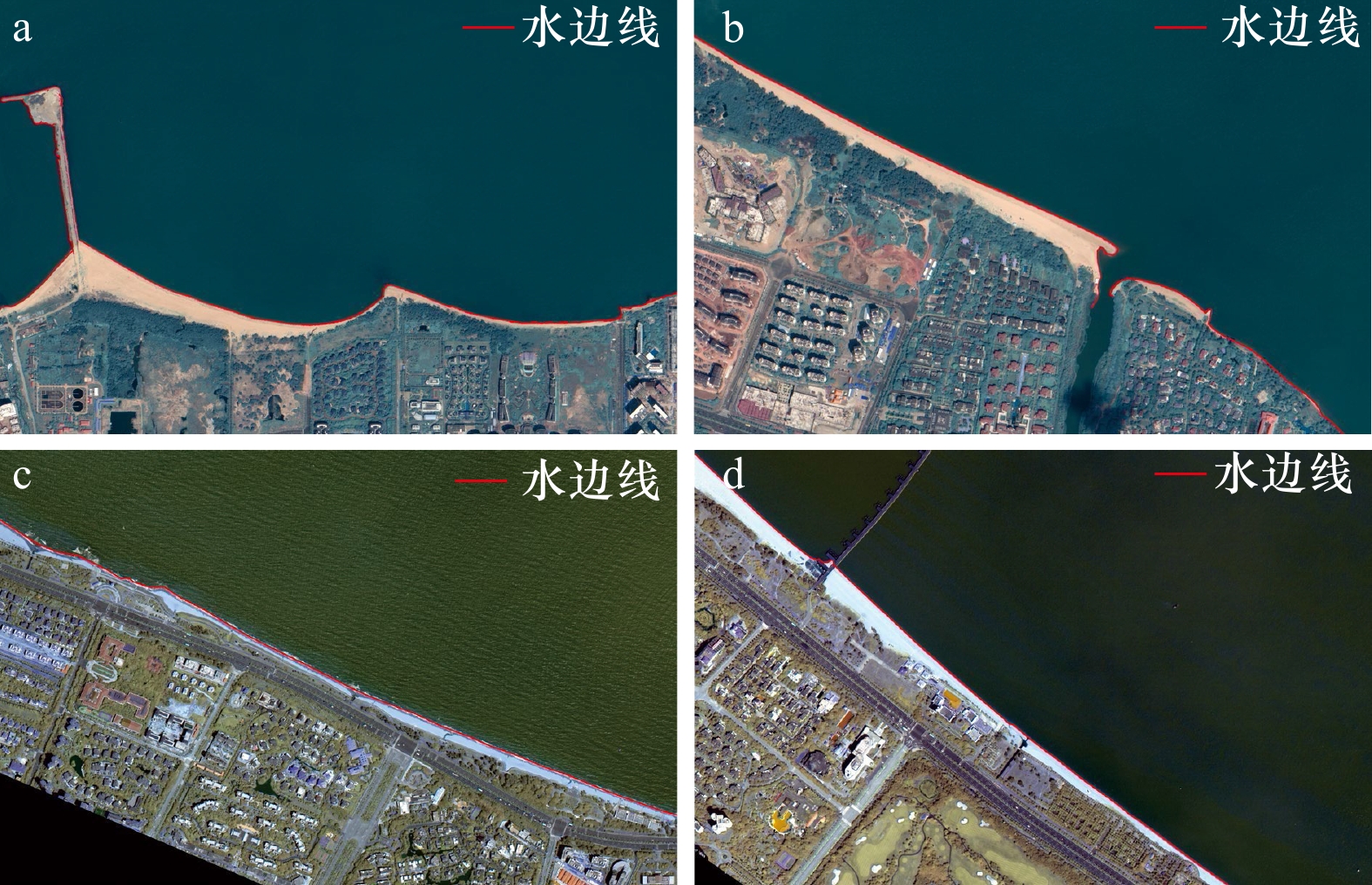
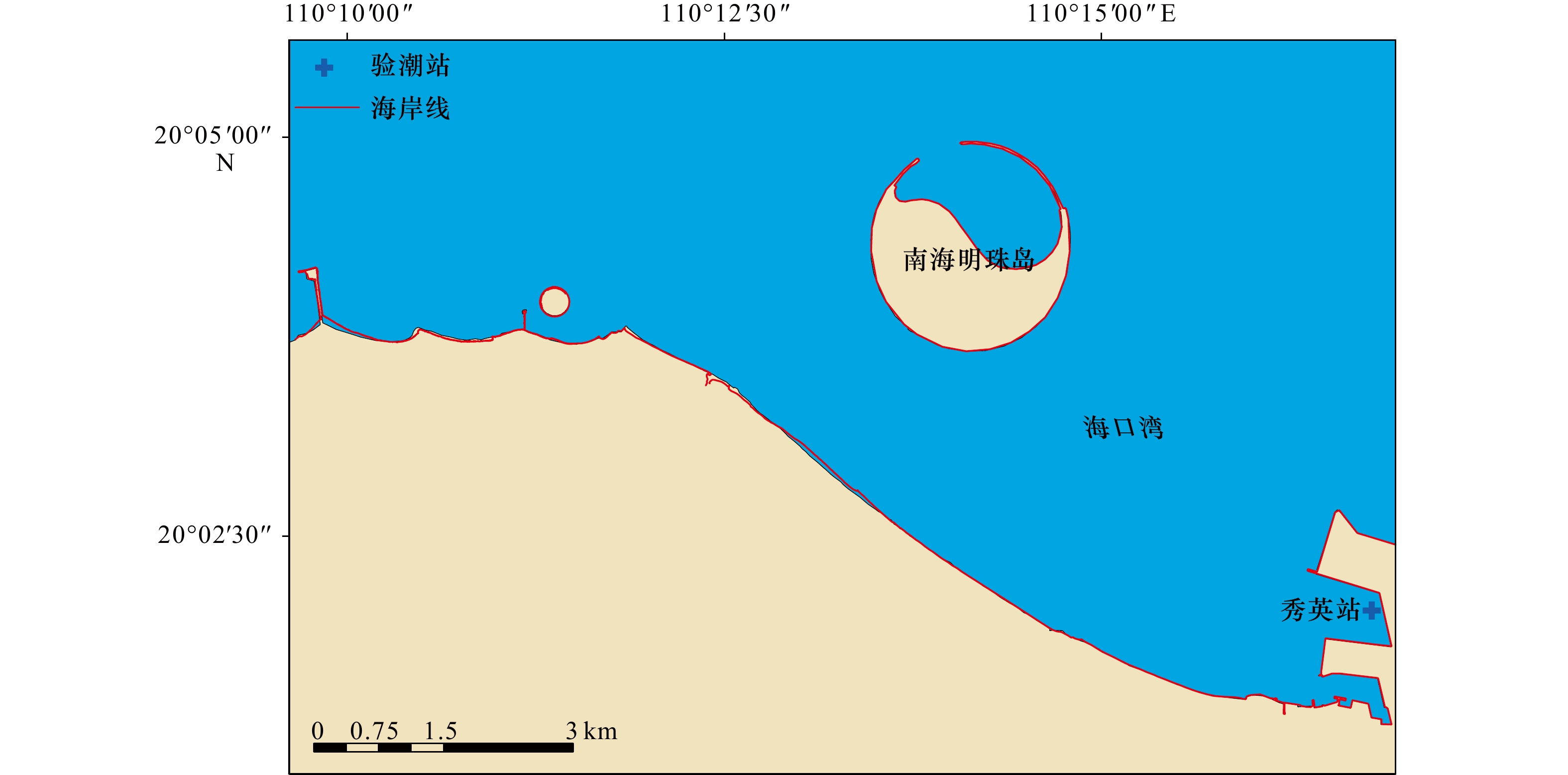
摘要: 通过遥感影像稳定获取大范围、连续性海岸线数据,是开展海岸带研究的重要手段之一。针对传统边缘检测算法处理高分辨率遥感影像存在的噪声敏感性、阈值不稳定性等问题,引入一种强鲁棒性的结构森林边缘检测(Strected Forests Edge Detection, SE)算法,对海口市西海岸砂质岸线进行识别,并提出基于Bruun-Dean平衡剖面模式建立拟合剖面模型的潮位校正新方法,结合实测数据对提取结果进行了精度评估和误差分析,最终提取得到了精细海岸线数据。研究表明,SE算法检测所得水边线结果清晰细腻,对比Roberts算子、Canny算子、LoG算子等传统边缘检测算子法更加精准高效,适用于高分遥感影像海岸线提取研究;针对砂质岸线的潮位校正,基于RTK实测剖面数据和拟合剖面模式建立的拟合剖面模型,克服了传统线性模型误差较大的问题,提升了海岸线校正的精度和可行性;基于实测岸线,使用断面法对结果进行定量分析,验证所得提取岸线定位精度优于2.5 m。Abstract: The stable acquisition of large-scale and continuous coastline data through remote sensing is an important basis for the development of coastal zone research. Aiming at the problems of noise sensitivity and threshold instability in the traditional edge detection algorithm for high-resolution remote sensing images, the strected forests edge detection algorithm based on the structured random forest model is introduced to identify the sandy shoreline of the west coast of Haikou City, and proposed based on the Bruun-Dean balanced profile model, a new method of tide level correction is established to fit the profile model, and finally the fine coastline data is extracted. Based on the measured data, the precision evaluation and error analysis of the extraction results are carried out, and the prospects for method improvement and popularization and application are put forward. The research show that: (1) the result of the water edge line detected by the strected forests edge detection algorithm is clear and delicate, which is more accurate and efficient than the traditional edge detection operator methods such as Roberts operator, Canny operator, and LoG operator, and is suitable for the study of coastline extraction from high-resolution remote sensing images; (2) aiming at the tide level correction of the sandy coastline, the fitted profile model established based on the RTK measured data and the fitted profile model overcomes the large error of the traditional linear model and improves the accuracy and feasibility of the coastline correction; (3) based on actual measurement for the shoreline, the results are quantitatively analyzed using the section method, and it is verified that the positioning accuracy of the extracted shoreline is better than 2.5 m.
-
Key words:
- WorldView-2 /
- coastline /
- edge detection /
- balanced profile mode /
- tide level correction /
- high resolution image
-
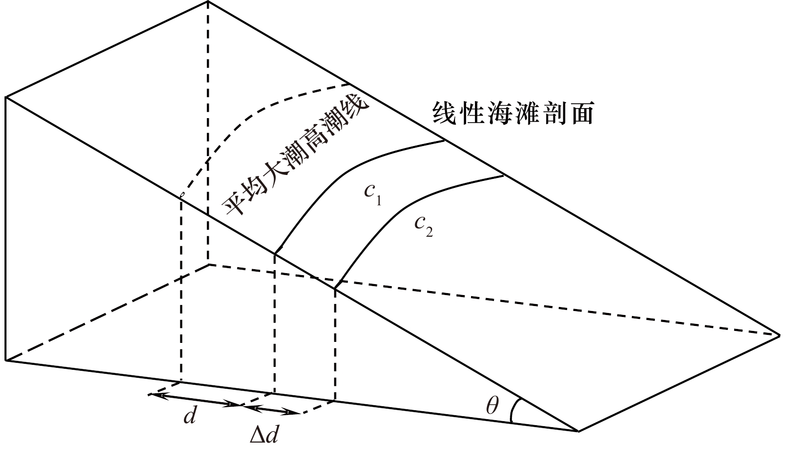

图 4 拟合剖面潮位校正模型原理
Fig. 4 The principle of the tide level correction model of the fitted profile
表 1 边缘检测算法质量评价结果
Tab. 1 Quality evaluation results edge detection algorithm
边缘检测算法 帧速率/fps 连续性(Cdr)/% F值/% 阈值参数 SE 60 92.7 74.3 自适应 Roberts 15 75.4 53.9 0~1 Canny 15 83.5 61.1 0~1 LoG 15 56.3 48.3 自适应  下载: 导出CSV
表 2 拟合模型评价参数
Tab. 2 Fitting model evaluation parameter
模型 误差平方和 确定系数 均方根误差 剖面模型 15.18 0.93 0.24 线性模型 24.41 0.78 0.32
下载: 导出CSV
-
[1] 毋亭, 侯西勇. 海岸线变化研究综述[J]. 生态学报, 2016, 36(4): 1170−1182.Wu Ting, Hou Xiyong. Review of research on coastline changes[J]. Acta Ecologica Sinica, 2016, 36(4): 1170−1182. [2] Wahl T, Haigh I D, Woodworth P L, et al. Observed mean sea level changes around the North Sea coastline from 1800 to present[J]. Earth-Science Reviews, 2013, 124: 51−67. doi: 10.1016/j.earscirev.2013.05.003 [3] 蔡锋, 苏贤泽, 曹惠美, 等. 华南砂质海滩的动力地貌分析[J]. 海洋学报, 2005, 27(2): 106−114.Cai Feng, Su Xianze, Cao Huimei, et al. Analysis on morphodynamics of sandy beaches in South China[J]. Haiyang Xuebao, 2005, 27(2): 106−114. [4] Vos K, Harley M D, Splinter K D, et al. Sub-annual to multi-decadal shoreline variability from publicly available satellite imagery[J]. Coastal Engineering, 2019, 150: 160−174. doi: 10.1016/j.coastaleng.2019.04.004 [5] 曹超, 朱铠, 蔡锋, 等. 厦门海岸类型变迁与经济发展的关联性研究[J]. 海洋开发与管理, 2021, 38(4): 69−74. doi: 10.3969/j.issn.1005-9857.2021.04.010Cao Chao, Zhu Kai, Cai Feng, et al. The relative of coastal change characteristic and economic development in Xiamen[J]. Ocean Development and Management, 2021, 38(4): 69−74. doi: 10.3969/j.issn.1005-9857.2021.04.010 [6] 吴一全, 刘林忠. 遥感影像的海岸线自动提取方法研究进展[J]. 遥感学报, 2019, 23(4): 582−602.Wu Yiquan, Liu Linzhong. Research progress on methods of automatic coastline extraction based on remote sensing images[J]. Journal of Remote Sensing, 2019, 23(4): 582−602. [7] 刘善伟, 张杰, 马毅, 等. 遥感与DEM相结合的海岸线高精度提取方法[J]. 遥感技术与应用, 2011, 26(5): 613−618. doi: 10.11873/j.issn.1004-0323.2011.5.613Liu Shanwei, Zhang Jie, Ma Yi, et al. Coastline extraction method based on remote sensing and DEM[J]. Remote Sensing Technology and Application, 2011, 26(5): 613−618. doi: 10.11873/j.issn.1004-0323.2011.5.613 [8] Descombes X, Moctezuma M, Maître H, et al. Coastline detection by a Markovian segmentation on SAR images[J]. Signal Processing, 1996, 55(1): 123−132. doi: 10.1016/S0165-1684(96)00125-9 [9] Mcfeeters S K. The use of the normalized difference water index (NDWI) in the delineation of open water features[J]. International Journal of Remote Sensing, 1996, 17(7): 1425−1432. doi: 10.1080/01431169608948714 [10] Bachofer F, Quénéhervé G, Zwiener T, et al. Comparative analysis of edge detection techniques for SAR images[J]. European Journal of Remote Sensing, 2016, 49(1): 205−224. doi: 10.5721/EuJRS20164912 [11] Liu H, Jezek K C. Automated extraction of coastline from satellite imagery by integrating Canny edge detection and locally adaptive thresholding methods[J]. International Journal of Remote Sensing, 2004, 25(5): 937−958. doi: 10.1080/0143116031000139890 [12] 张华国, 郭艳霞, 黄韦艮, 等. 1986年以来杭州湾围垦淤涨状况卫星遥感调查[J]. 国土资源遥感, 2005(2): 50−54.Zhang Huaguo, Guo Yanxia, Huang Weigen, et al. A remote sensing investigation of inning and silting in Hangzhou Bay since 1986[J]. Remote Sensing for Land & Resources, 2005(2): 50−54. [13] 贾明明, 刘殿伟, 王宗明, 等. 面向对象方法和多源遥感数据的杭州湾海岸线提取分析[J]. 地球信息科学学报, 2013, 15(2): 262−269. doi: 10.3724/SP.J.1047.2013.001262Jia Mingming, Liu Dianwei, Wang Zongming, et al. Coastline changes in Hangzhou Bay based on object-oriented method using multi-source remote sensing data[J]. Journal of Geo-Information Science, 2013, 15(2): 262−269. doi: 10.3724/SP.J.1047.2013.001262 [14] 詹雅婷, 朱利, 孙永华, 等. 海岸线遥感光谱角度−距离相似度生长模型自动化提取[J]. 遥感学报, 2017, 21(3): 458−469.Zhan Yating, Zhu Li, Sun Yonghua, et al. Automatic extraction of coastline via spectral angle-distance similarity growth model[J]. Journal of Remote Sensing, 2017, 21(3): 458−469. [15] 谢明鸿, 张亚飞, 付琨. 基于种子点增长的SAR图像海岸线自动提取算法[J]. 中国科学院研究生院学报, 2007, 24(1): 93−98.Xie Minghong, Zhang Yafei, Fu Kun. Algorithm of detection coastline from SAR images based on seeds growing[J]. Journal of the Graduate School of the Chinese Academy of Sciences, 2007, 24(1): 93−98. [16] Toure S, Diop O, Kpalma K, et al. Shoreline detection using optical remote sensing: a review[J]. ISPRS International Journal of Geo-Information, 2019, 8(2): 75. doi: 10.3390/ijgi8020075 [17] 刘晓莉, 范玉茹. 常用边缘检测算法在不同影像海岸线中提取比较研究[J]. 测绘与空间地理信息, 2014, 37(11): 149−151. doi: 10.3969/j.issn.1672-5867.2014.11.045Liu Xiaoli, Fan Yuru. Study on comparison of common edge detection algorithms extraction in different image coastline[J]. Geomatics & Spatial Information Technology, 2014, 37(11): 149−151. doi: 10.3969/j.issn.1672-5867.2014.11.045 [18] 于杰, 杜飞雁, 陈国宝, 等. 基于遥感技术的大亚湾海岸线的变迁研究[J]. 遥感技术与应用, 2009, 24(4): 512−516. doi: 10.11873/j.issn.1004-0323.2009.4.512Yu Jie, Du Feiyan, Chen Guobao, et al. Research on coastline change of daya bay using remote sensing technology[J]. Remote Sensing Technology and Application, 2009, 24(4): 512−516. doi: 10.11873/j.issn.1004-0323.2009.4.512 [19] Zhao Long, Fan Ling, Wang Chao, et al. A non-supervised method for shoreline extraction using high resolution SAR image[C]//Proceedings of 2012 International Conference on Computer Vision in Remote Sensing. Xiamen: IEEE, 2012: 317−322. [20] 蒋科迪, 殷勇, 范开桂, 等. 基于Canny算子的南通江海岸线研究[J]. 测绘通报, 2019(10): 83−88.Jiang Kedi, Yin Yong, Fan Kaigui, et al. Study on nantong coastlines based on Canny operator[J]. Bulletin of Surveying and Mapping, 2019(10): 83−88. [21] Bouchahma M, Yan Wanglin. Monitoring shoreline change on Djerba Island using GIS and multi-temporal satellite data[J]. Arabian Journal of Geosciences, 2014, 7(9): 3705−3713. doi: 10.1007/s12517-013-1052-9 [22] Bachofer F, Quénéhervé G, Märker M. The delineation of paleo-shorelines in the lake manyara basin using TerraSAR-X data[J]. Remote Sensing, 2014, 6(3): 2195−2212. doi: 10.3390/rs6032195 [23] Kass M, Witkin A, Terzopoulos D. Snakes: active contour models[J]. International Journal of Computer Vision, 1988, 1(4): 321−331. doi: 10.1007/BF00133570 [24] De Laurentiis R, Dellepiane S G, Bo G. Texture features analysis for coastline extraction in remotely sensed images[C]//Proceedings of SPIE 4541, Image and Signal Processing for Remote Sensing VII. Toulouse, France: SPIE, 2002. [25] García-Rubio G, Huntley D, Russell P. Evaluating shoreline identification using optical satellite images[J]. Marine Geology, 2015, 359: 96−105. doi: 10.1016/j.margeo.2014.11.002 [26] 张旭凯, 张霞, 杨邦会, 等. 结合海岸类型和潮位校正的海岸线遥感提取[J]. 国土资源遥感, 2013, 25(4): 91−97.Zhang Xukai, Zhang Xia, Yang Banghui, et al. Coastline extraction using remote sensing based on coastal type and tidal correction[J]. Remote Sensing for Land & Resources, 2013, 25(4): 91−97. [27] Xu Hanqiu. Modification of normalised difference water index (NDWI) to enhance open water features in remotely sensed imagery[J]. International Journal of Remote Sensing, 2006, 27(14): 3025−3033. doi: 10.1080/01431160600589179 [28] 梁立, 刘庆生, 刘高焕, 等. 基于遥感影像的海岸线提取方法综述[J]. 地球信息科学学报, 2018, 20(12): 1745−1755. doi: 10.12082/dqxxkx.2018.180152Liang Li, Liu Qingsheng, Liu Gaohuan, et al. Review of coastline extraction methods based on remote sensing images[J]. Journal of Geo-Information Science, 2018, 20(12): 1745−1755. doi: 10.12082/dqxxkx.2018.180152 [29] 马小峰, 赵冬至, 张丰收, 等. 海岸线卫星遥感提取方法研究进展[J]. 遥感技术与应用, 2007, 22(4): 575−580. doi: 10.3969/j.issn.1004-0323.2007.04.017Ma Xiaofeng, Zhao Dongzhi, Zhang Fengshou, et al. An overview of means of withdrawing coastline by remote sensing[J]. Remote Sensing Technology and Application, 2007, 22(4): 575−580. doi: 10.3969/j.issn.1004-0323.2007.04.017 [30] Stockdon H F, Sallenger Jr A H, List J H, et al. Estimation of shoreline position and change using airborne topographic LIDAR data[J]. Journal of Coastal Research, 2002, 18(3): 502−513. [31] 陈子燊. 海滩剖面形态与地形动态研究的进展[J]. 海洋通报, 1997, 16(1): 86−91.Chen Zishen. Progress in studies on the shapes and dynamics of beach profiles[J]. Marine Science Bulletin, 1997, 16(1): 86−91. [32] Dollár P, Zitnick C L. Fast edge detection using structured forests[J]. IEEE Transactions on Pattern Analysis and Machine Intelligence, 2015, 37(8): 1558−1570. doi: 10.1109/TPAMI.2014.2377715 [33] Ho Tin Kam. Random decision forests[C]//Proceedings of 3rd International Conference on Document Analysis and Recognition. [S.l.]: [s.n.], 1995, 278−282. [34] Breiman L. Random forests[J]. Machine Learning, 2001, 45(1): 5−32. doi: 10.1023/A:1010933404324 [35] 李翠锦, 瞿中. 基于深度学习的图像边缘检测算法综述[J]. 计算机应用, 2020, 40(11): 3280−3288.Li Cuijin, Qu Zhong. Review of image edge detection algorithms based on deep learning[J]. Journal of Computer Applications, 2020, 40(11): 3280−3288. [36] Bruun P. Coast erosion and the development of beach profiles[J]. Journal of Waterway, Port, Coastal, and Ocean Engineering, 1954, 54. [37] Dean R G. Equilibrium beach profile: characteristics and application[J]. Journal of Coastal Research, 1991, 7(1): 53−84. [38] Dolan R, Hayden B P, Felder W. Systematic variations in inshore bathymetry[J]. The Journal of Geology, 1977, 85(2): 129−141. doi: 10.1086/628281 [39] Dean R G. Beach Nourishment: Theory and Practice[M]. Cai Feng, Cao Huimei, Liu Jianhui, trans. Beijing: China Ocean Press, 2010. [40] 王红平, 刘修国, 罗红霞, 等. 基于RPC模型的IRS-P5影像正射校正[J]. 地球科学——中国地质大学学报, 2010, 35(3): 485−489. doi: 10.3799/dqkx.2010.061Wang Hongping, Liu Xiuguo, Luo Hongxia, et al. IRS-P5 satellite image ortho corrections using RPC model[J]. Earth Science—Journal of China University of Geosciences, 2010, 35(3): 485−489. doi: 10.3799/dqkx.2010.061 [41] 姜红艳, 邢立新, 梁立恒, 等. PanSharpening自动融合算法及应用研究[J]. 测绘与空间地理信息, 2008, 31(5): 73−75,78. doi: 10.3969/j.issn.1672-5867.2008.05.021Jiang Hongyan, Xing Lixin, Liang Liheng, et al. Study on PanSharpening auto-fusion arithmetic and application[J]. Geomatics & Spatial Information Technology, 2008, 31(5): 73−75,78. doi: 10.3969/j.issn.1672-5867.2008.05.021 [42] Huang Y J, Powers R, Montelione G T. Protein NMR recall, precision, and F-measure scores (RPF scores): structure quality assessment measures based on information retrieval statistics[J]. Journal of the American Chemical Society, 2005, 127(6): 1665−1674. doi: 10.1021/ja047109h [43] Moore B D. Beach profile evolution in response to changes in water level and wave height[D]. Newark: University of Delaware, 1982. [44] Dean R G . Coastal sediment processes: Toward engineering solutions[C]//Conference on Coastal Sediments, [S.l.]: [s.n.], 1987. [45] Zhou Yong, Zhang Dong, Cutler M E J, et al. Estimating muddy intertidal flat slopes under varied coastal morphology using sequential satellite data and spatial analysis[J]. Estuarine, Coastal and Shelf Science, 2021, 251: 107183. doi: 10.1016/j.ecss.2021.107183 -


图(12) / 表(2)
计量
- 文章访问数: 957
- HTML全文浏览量: 302
- PDF下载量: 121
- 被引次数: 0
