| Citation: | Liu Jianyang,Mao Zhihua,Tao Bangyi, et al. Geometric positioning method of HY-1C/D satellite Chinese ocean color and temperature scanner[J]. Haiyang Xuebao,2022, 44(5):47–61 doi: 10.12284/hyxb2022029

|

| [1] |
曾丽萍, 王振松. 一种新的MODIS 0级数据地理定位方法[J]. 现代电子技术, 2008, 31(2): 173−174. doi: 10.3969/j.issn.1004-373X.2008.02.057
Zeng Liping, Wang Zhensong. A new MODIS 0 level earth location algorithm[J]. Modern Electronics Technique, 2008, 31(2): 173−174. doi: 10.3969/j.issn.1004-373X.2008.02.057
|
| [2] |
Nishihama M, Wolfe R, Solomon D, et al. MODIS level 1A earth location: algorithm theoretical basis document version 3.0[EB/OL]. (1997−08−26) [2021−04−15]. https://modis.gsfc.nasa.gov/data/atbd/atbd_mod28_v3.pdf.
|
| [3] |
孙从容. 中国海洋一号卫星遥感图像GPS地理定位算法研究与实现[J]. 航天器工程, 2003, 12(3): 144−150.
Sun Congrong. Research and implementation of GPS geolocation algorithm for China HY-1 satellite remote sensing image[J]. Spacecraft Engineering, 2003, 12(3): 144−150.
|
| [4] |
关敏, 杨忠东. FY-3微波成像仪遥感图像地理定位方法研究[J]. 遥感学报, 2009, 13(3): 469−474. doi: 10.11834/jrs.20090310
Guan Min, Yang Zhongdong. Geolocation method for FY-3 MWRI’s remote sensing image[J]. Journal of Remote Sensing, 2009, 13(3): 469−474. doi: 10.11834/jrs.20090310
|
| [5] |
Baker N. Joint Polar Satellite System VIIRS Geolocation Algorithm Theoretical Basis Document[R/OL]. (2011−06−31) [2021−04−15]. https://lpdaac.usgs.gov/documents/135/VNP03_ATBD.pdf
|
| [6] |
潘德炉, 毛天明, 李淑菁. 海洋卫星资料的地理定位及相关几何参数算法研究[J]. 海洋学报, 1997, 19(5): 56−68.
Pan Delu, Mao Tianming, Li Shujing. Research on geolocation of marine satellite data and related geometric parameter algorithms[J]. Haiyang Xuebao, 1997, 19(5): 56−68.
|
| [7] |
柴毅. 基于多敏感器的卫星在轨高精度姿态确定技术研究[D]. 哈尔滨: 哈尔滨工程大学, 2018.
Chai Yi. Research on high accuracy attitude determination methods for on-orbit satellite based on multiple sensors[D]. Harbin: Harbin Engineering University, 2018.
|
| [8] |
边少锋, 纪兵, 李厚朴. 卫星导航系统概论[M]. 2版. 北京: 测绘出版社, 2016.
Bian Shaofeng, Ji Bing, Li Houpu. Introduction to Satellite Navigation Systems[M]. 2nd ed. Beijing: Surveging and Mapping Press, 2016.
|
| [9] |
关敏, 谷松岩, 杨忠东. 风云三号微波湿度计遥感图像地理定位方法[J]. 遥感技术与应用, 2008, 23(6): 712−716. doi: 10.11873/j.issn.1004-0323.2008.6.712
Guan Min, Gu Songyan, Yang Zhongdong. Geolocation method for FY-3 MWHS’ remote sensing image[J]. Remote Sensing Technology and Application, 2008, 23(6): 712−716. doi: 10.11873/j.issn.1004-0323.2008.6.712
|
| [10] |
窦长勇, 岳昔娟. 轨道坐标系到地心固定坐标系的直接转换方法[J]. 航天返回与遥感, 2016, 37(5): 86−94. doi: 10.3969/j.issn.1009-8518.2016.05.010
Dou Changyong, Yue Xijuan. Direct transformation from orbital to earth-centered earth-fixed reference frame[J]. Spacecraft Recovery & Remote Sensing, 2016, 37(5): 86−94. doi: 10.3969/j.issn.1009-8518.2016.05.010
|
| [11] |
Noredlinger P D, Klein L. Theoretical basis of the SDP toolkit geolocation package for the ECS project. Landover: Hughes Applied Information Systems[R/OL]. (1995−05−18) [2021−04−15]. https://citeseerx.ist.psu.edu/viewdoc/download?doi=10.1.1.131.7265&rep=rep1&type=pdf.
|
| [12] |
杨磊, 杨忠东, 张里阳, 等. 极轨气象卫星有效载荷航空校飞数据地理定位[J]. 计算机工程与应用, 2008, 44(30): 202−205. doi: 10.3778/j.issn.1002-8331.2008.30.062
Yang Lei, Yang Zhongdong, Zhang Liyang, et al. Geolocation of airborne data for polar meteorological satellite payloads[J]. Computer Engineering and Applications, 2008, 44(30): 202−205. doi: 10.3778/j.issn.1002-8331.2008.30.062
|
| [13] |
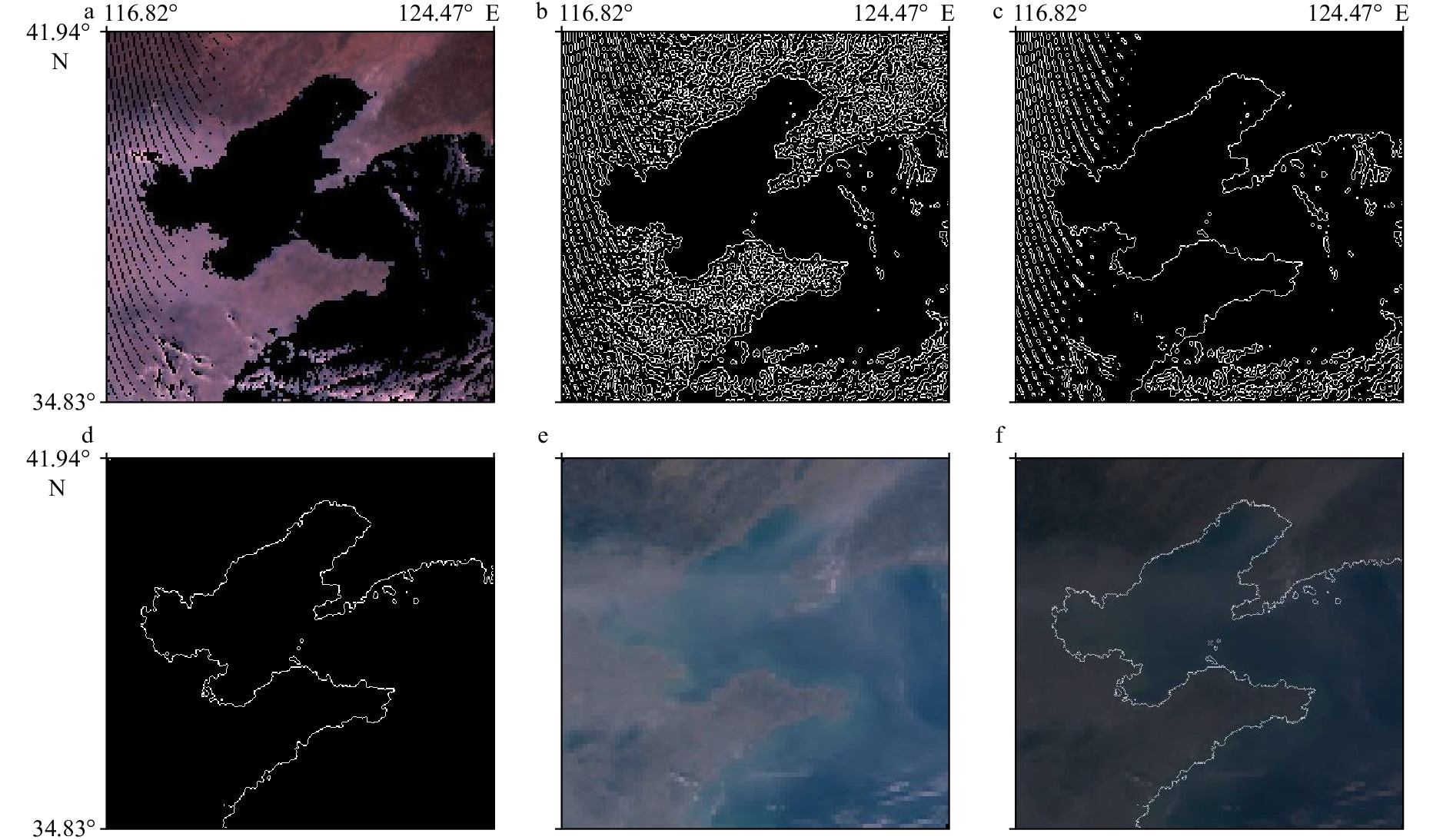
熊显名, 尧雪娟, 滕惠忠, 等. 基于遥感图像光谱特征的水陆分界线提取[C]//2007’仪表, 自动化及先进集成技术大会论文集. 重庆: 《仪器仪表学报》杂志社, 2007.
Xiong Xianming, Yao Xuejuan, Teng Huizhong, et al. Shoreline extract based on spectral signatures of remote sensing images[C]//2007’ Instrumentation, Automation and Advanced Integration Technology Conference. Chongqing: Chinese Journal of Scientific Instrument, 2007.
|
| [14] |
Lykhovyd P V. Forecasting oil crops yields on the regional scale using normalized difference vegetation index[J]. Journal of Ecological Engineering, 2021, 22(3): 53−57. doi: 10.12911/22998993/132436
|
| [15] |
李继红, 焦裕欣. 东北地区归一化植被指数与环境因子间的尺度依存关系[J]. 东北林业大学学报, 2021, 49(2): 70−77.
Li Jihong, Jiao Yuxin. Dependence between NDVI and environmental factors in northeast China[J]. Journal of Northeast Forestry University, 2021, 49(2): 70−77.
|
| [16] |
黄慧, 董林鹭, 何建华, 等. 强噪声下改进Canny算法的边缘检测[J]. 计算机技术与发展, 2021, 31(1): 83−87. doi: 10.3969/j.issn.1673-629X.2021.01.015
Huang Hui, Dong Linlu, He Jianhua, et al. Edge detection of an improved canny algorithm under strong noise[J]. Computer Technology and Development, 2021, 31(1): 83−87. doi: 10.3969/j.issn.1673-629X.2021.01.015
|
| [17] |
Loderer M, Beitelschmidt M. Improved edge detection based on fractional derivatives for real-time measurement systems[J]. PAMM, 2019, 19(1): e201900439.
|
| [18] |
Howard M, Hock M C, Meehan B T, et al. A locally adapting technique for edge detection using image segmentation[J]. SIAM Journal on Scientific Computing, 2018, 40(4): B1161−B1179. doi: 10.1137/17M1155363
|
| [19] |
黄祥李, 张杰, 计科峰, 等. 基于GSHHG数据库与改进CV模型的SAR图像海陆分割算法[C]//第五届高分辨率对地观测学术年会论文集. 西安: 中国科学院高分重大专项管理办公室, 2018.
Huang Xiangli, Zhang Jie, Ji Kefeng, et al. Sea-land segmentation algorithm of SAR image based on GSHHG database and improved CV model[C]//The Fifth Annual Conference on High Resolution Earth Observation, Xi’an: High Score Major Project Management Office of Chinese Academy of Sciences, 2018.
|
| [20] |
王存良. 对地面某区域某时段连续覆盖的卫星轨道计算[J]. 信息与电子工程, 2012, 10(4): 421−425. doi: 10.3969/j.issn.1672-2892.2012.04.008
Wang Cunliang. Calculation of the satellite orbit covering certain area on the ground in some period of time[J]. Information and Electronic Engineering, 2012, 10(4): 421−425. doi: 10.3969/j.issn.1672-2892.2012.04.008
|
| [21] |
李跃跃, 胡彩波, 孙江艳, 等. 基于STK/Matlab的导航星座性能分析[C]//第九届中国卫星导航学术年会论文集——S08 测试评估技术. 哈尔滨: 中科北斗汇(北京)科技有限公司, 2018.
Li Yueyue, Hu Caibo, Sun Jiangyan, et al. Performance analysis of navigation constellation based on STK/Matlab[C]//The Ninth China Satellite Navigation Conference. Harbin: Zhongke Beidouhui (Beijing) Technology Co., Ltd, 2018.
|
Figures(13) / Tables(9)


 DownLoad: