| Citation: | Zhang Chenyu,Chen Shenliang,Li Peng, et al. Spatiotemporal dynamic remote sensing monitoring of typical wetland vegetation in the Current Huanghe River Estuary Reserve[J]. Haiyang Xuebao,2022, 44(1):125–136 doi: 10.12284/hyxb2022014

|

| [1] |
Barbier E B. Valuing ecosystem services for coastal wetland protection and restoration: progress and challenges[J]. Resources, 2013, 2(3): 213−230. doi: 10.3390/resources2030213
|
| [2] |
宗秀影, 刘高焕, 乔玉良, 等. 黄河三角洲湿地景观格局动态变化分析[J]. 地球信息科学学报, 2009, 11(1): 91−97. doi: 10.3969/j.issn.1560-8999.2009.01.014
Zong Xiuying, Liu Gaohuan, Qiao Yuliang, et al. Study on dynamic changes of wetland landscape pattern in Yellow River Delta[J]. Journal of Geo-Information Science, 2009, 11(1): 91−97. doi: 10.3969/j.issn.1560-8999.2009.01.014
|
| [3] |
Fitzsimmons O N, Ballard B M, Merendino M T, et al. Implications of coastal wetland management to nonbreeding waterbirds in Texas[J]. Wetlands, 2012, 32(6): 1057−1066. doi: 10.1007/s13157-012-0336-2
|
| [4] |
Fu Bolin, Wang Yeqiao, Campbell A, et al. Comparison of object-based and pixel-based Random Forest algorithm for wetland vegetation mapping using high spatial resolution GF-1 and SAR data[J]. Ecological Indicators, 2017, 73: 105−117. doi: 10.1016/j.ecolind.2016.09.029
|
| [5] |
Jin Kangkang, Fan Jinshan, Zhao Xuan, et al. Analysis on dynamic change of vegetation coverage in coastal wetland of Yellow River Delta[J]. IOP Conference Series: Earth and Environmental Science, 2020, 450: 012108. doi: 10.1088/1755-1315/450/1/012108
|
| [6] |
韩美, 张晓惠, 刘丽云. 黄河三角洲湿地研究进展[J]. 生态环境学报, 2006, 15(4): 872−875. doi: 10.3969/j.issn.1674-5906.2006.04.041
Han Mei, Zhang Xiaohui, Liu Liyun. Research progress on wetland of the Yellow River Delta[J]. Ecology and Environment, 2006, 15(4): 872−875. doi: 10.3969/j.issn.1674-5906.2006.04.041
|
| [7] |
莫利江, 曹宇, 胡远满, 等. 面向对象的湿地景观遥感分类——以杭州湾南岸地区为例[J]. 湿地科学, 2012, 10(2): 206−213. doi: 10.3969/j.issn.1672-5948.2012.02.013
Mo Lijiang, Cao Yu, Hu Yuanman, et al. Object-oriented classification for satellite remote sensing of wetlands: a case study in southern Hangzhou Bay area[J]. Wetland Science, 2012, 10(2): 206−213. doi: 10.3969/j.issn.1672-5948.2012.02.013
|
| [8] |
Ren Kai, Sun Weiwei, Meng Xiangchao, et al. Fusing China GF-5 hyperspectral data with GF-1, GF-2 and sentinel-2A multispectral data: which methods should Be used?[J]. Remote Sensing, 2020, 12(5): 882. doi: 10.3390/rs12050882
|
| [9] |
Sun Weiwei, Du Qian. Hyperspectral band selection: a review[J]. IEEE Geoscience and Remote Sensing Magazine, 2019, 7(2): 118−139. doi: 10.1109/MGRS.2019.2911100
|
| [10] |
Zhu Yuanhui, Liu Kai, Liu Lin, et al. Retrieval of mangrove aboveground biomass at the individual species level with WorldView-2 images[J]. Remote Sensing, 2015, 7(9): 12192−12214. doi: 10.3390/rs70912192
|
| [11] |
Wang Anqi, Chen Jiadai, Jing Changwei, et al. Monitoring the invasion of Spartina alterniflora from 1993 to 2014 with Landsat TM and SPOT 6 satellite data in Yueqing Bay, China[J]. PLoS ONE, 2015, 10(8): e0135538. doi: 10.1371/journal.pone.0135538
|
| [12] |
Ai Jinquan, Gao Wei, Gao Zhiqiang, et al. Phenology-based Spartina alterniflora mapping in coastal wetland of the Yangtze Estuary using time series of GaoFen satellite No. 1 wide field of view imagery[J]. Journal of Applied Remote Sensing, 2017, 11(2): 026020. doi: 10.1117/1.JRS.11.026020
|
| [13] |
Huang Huamei, Zhang Liquan. A study of the population dynamics of Spartina alterniflora at Jiuduansha shoals, Shanghai, China[J]. Ecological Engineering, 2007, 29(2): 164−172. doi: 10.1016/j.ecoleng.2006.06.005
|
| [14] |
Lee T M, Yeh H C. Applying remote sensing techniques to monitor shifting wetland vegetation: a case study of Danshui River estuary mangrove communities, Taiwan[J]. Ecological Engineering, 2009, 35(4): 487−496. doi: 10.1016/j.ecoleng.2008.01.007
|
| [15] |
Zhang Xi, Xiao Xiangming, Wang Xinxin, et al. Quantifying expansion and removal of Spartina alterniflora on Chongming Island, China, using time series Landsat images during 1995−2018[J]. Remote Sensing of Environment, 2020, 247: 111916. doi: 10.1016/j.rse.2020.111916
|
| [16] |
Laba M, Downs R, Smith S, et al. Mapping invasive wetland plants in the Hudson River National Estuarine Research Reserve using quickbird satellite imagery[J]. Remote Sensing of Environment, 2008, 112(1): 286−300. doi: 10.1016/j.rse.2007.05.003
|
| [17] |
Szantoi Z, Escobedo F J, Abd-Elrahman A, et al. Classifying spatially heterogeneous wetland communities using machine learning algorithms and spectral and textural features[J]. Environmental Monitoring and Assessment, 2015, 187(5): 262. doi: 10.1007/s10661-015-4426-5
|
| [18] |
Zlinszky A, Mücke W, Lehner H, et al. Categorizing wetland vegetation byairborne laser scanning on Lake Balaton and Kis-Balaton, Hungary[J]. Remote Sensing, 2012, 4(6): 1617−1650. doi: 10.3390/rs4061617
|
| [19] |
Han Xingxing, Chen Xiaoling, Feng Lian. Four decades of winter wetland changes in Poyang Lake based on Landsat observations between 1973 and 2013[J]. Remote Sensing of Environment, 2015, 156: 426−437. doi: 10.1016/j.rse.2014.10.003
|
| [20] |
Timm B C, McGarigal K. Fine-scale remotely-sensed cover mapping of coastal dune and salt marsh ecosystems at Cape Cod National Seashore using Random Forests[J]. Remote Sensing of Environment, 2012, 127: 106−117. doi: 10.1016/j.rse.2012.08.033
|
| [21] |
毕恺艺, 牛铮, 黄妮, 等. 基于Sentinel-2A时序数据和面向对象决策树方法的植被识别[J]. 地理与地理信息科学, 2017, 33(5): 16−20, 27. doi: 10.3969/j.issn.1672-0504.2017.05.003
Bi Kaiyi, Niu Zheng, Huang Ni, et al. Identifying vegetation with decision tree model based on object-oriented method using multi-temporal Sentinel-2A images[J]. Geography and Geo-Information Science, 2017, 33(5): 16−20, 27. doi: 10.3969/j.issn.1672-0504.2017.05.003
|
| [22] |
Lantz N J, Wang Jinfei. Object-based classification of Worldview-2 imagery for mapping invasive common reed, Phragmites australis[J]. Canadian Journal of Remote Sensing, 2013, 39(4): 328−340. doi: 10.5589/m13-041
|
| [23] |
Cao Mingchang, Liu Gaohuan, Zhang Xiaoyu. An object-oriented approach to map wetland vegetation: a case study of Yellow River Delta, 2007[C]//2007 IEEE International Geoscience and Remote Sensing Symposium. Barcelona, Spain: IEEE, 2007: 4585−4587.
|
| [24] |
徐洋. 黄河口沙嘴地貌特征对植被分布格局的影响研究[D]. 烟台: 鲁东大学, 2019.
Xu Yang. Study on the impacts of Yellow River estuary sand mouth geomorphological characteristics on vegetation distribution pattern[D]. Yantai: Ludong University, 2019.
|
| [25] |
杨俊芳, 马毅, 任广波, 等. 基于国产高分卫星遥感数据的现代黄河三角洲入侵植物互花米草监测方法[J]. 海洋环境科学, 2017, 36(4): 596−602.
Yang Junfang, Ma Yi, Ren Guangbo, et al. Monitoring method of invasive vegetation Spartina alterniflora in modern Yellow River Delta based on GF remote sensing data[J]. Marine Environmental Science, 2017, 36(4): 596−602.
|
| [26] |
刘康, 闫家国, 邹雨璇, 等. 黄河三角洲盐地碱蓬盐沼的时空分布动态[J]. 湿地科学, 2015, 13(6): 696−701.
Liu Kang, Yan Jiaguo, Zou Yuxuan, et al. Dynamics of spatial and temporal distribution of Suaeda salsas salt marshes in the Yellow River Delta[J]. Wetland Science, 2015, 13(6): 696−701.
|
| [27] |
Ren Guangbo, Zhao Yajie, Wang Jianbu, et al. Ecological effects analysis of Spartina alterniflora invasion within Yellow River Delta using long time series remote sensing imagery[J]. Estuarine, Coastal and Shelf Science, 2021, 249: 107111. doi: 10.1016/j.ecss.2020.107111
|
| [28] |
Ding Qiong, Chen Wu, King B A, et al. Coastal wetland investigations by airborne LiDAR: a case study in the Yellow River Delta, China[J]. Marine Technology Society Journal, 2011, 45(5): 59−70. doi: 10.4031/MTSJ.45.5.6
|
| [29] |
Sun Chao, Li Jialin, Liu Yongxue, et al. Plant species classification in salt marshes using phenological parameters derived from Sentinel-2 pixel-differential time-series[J]. Remote Sensing of Environment, 2021, 256: 112320. doi: 10.1016/j.rse.2021.112320
|
| [30] |
耿仁方, 付波霖, 蔡江涛, 等. 基于无人机影像和面向对象随机森林算法的岩溶湿地植被识别方法研究[J]. 地球信息科学学报, 2019, 21(8): 1295−1306. doi: 10.12082/dqxxkx.2019.180631
Geng Renfang, Fu Bolin, Cai Jiangtao, et al. Object-based karst wetland vegetation classification method using unmanned aerial vehicle images and random forest algorithm[J]. Journal of Geo-Information Science, 2019, 21(8): 1295−1306. doi: 10.12082/dqxxkx.2019.180631
|
| [31] |
Moffett K B, Gorelick S M. Distinguishing wetland vegetation and channel features with object-based image segmentation[J]. International Journal of Remote Sensing, 2013, 34(4): 1332−1354. doi: 10.1080/01431161.2012.718463
|
| [32] |
Liu Jianhua, Du Mingyu, Mao Zhengyuan. Scale computation on high spatial resolution remotely sensed imagery multi-scale segmentation[J]. International Journal of Remote Sensing, 2017, 38(18): 5186−5214. doi: 10.1080/01431161.2017.1325536
|
| [33] |
Drǎguţ L, Tiede D, Levick S R. ESP: a tool to estimate scale parameter for multiresolution image segmentation of remotely sensed data[J]. International Journal of Geographical Information Science, 2010, 24(6): 859−871. doi: 10.1080/13658810903174803
|
| [34] |
张磊, 宫兆宁, 王启为, 等. Sentinel-2影像多特征优选的黄河三角洲湿地信息提取[J]. 遥感学报, 2019, 23(2): 313−326.
Zhang Lei, Gong Zhaoning, Wang Qiwei, et al. Wetland mapping of Yellow River Delta wetlands based on multi-feature optimization of Sentinel-2 images[J]. Journal of Remote Sensing, 2019, 23(2): 313−326.
|
| [35] |
刘明月. 中国滨海湿地互花米草入侵遥感监测及变化分析[D]. 长春: 中国科学院大学(中国科学院东北地理与农业生态研究所), 2018.
Liu Mingyue. Remote sensing analysis of Spartina alterniflora in the coastal areas of China during 1990 to 2015[D]. Changchun: University of Chinese Academy of Sciences (Northeast Institute of Geography and Agroecology, Chinese Academy of Sciences), 2018.
|
| [36] |
Zhang Cheng, Gong Zhaoning, Qiu Huachang, et al. Mapping typical salt-marsh species in the Yellow River Delta wetland supported by temporal-spatial-spectral multidimensional features[J]. Science of the Total Environment, 2021, 783: 147061. doi: 10.1016/j.scitotenv.2021.147061
|
| [37] |
赵可夫, 冯立田, 张圣强, 等. 黄河三角洲不同生态型芦苇对盐度适应生理的研究Ⅱ. 不同生态型芦苇的光合气体交换特点[J]. 生态学报, 2000, 20(5): 795−799. doi: 10.3321/j.issn:1000-0933.2000.05.014
Zhao Kefu, Feng Litian, Zhang Shengqiang, et al. The salinity-adaptation physiology in different ecotypes of Phragmites communis in the Yellow River Delta Ⅱ. The characteristics of photosynthetic gas exchange in different ecotypes of Phragmites communis[J]. Acta Ecologica Sinica, 2000, 20(5): 795−799. doi: 10.3321/j.issn:1000-0933.2000.05.014
|

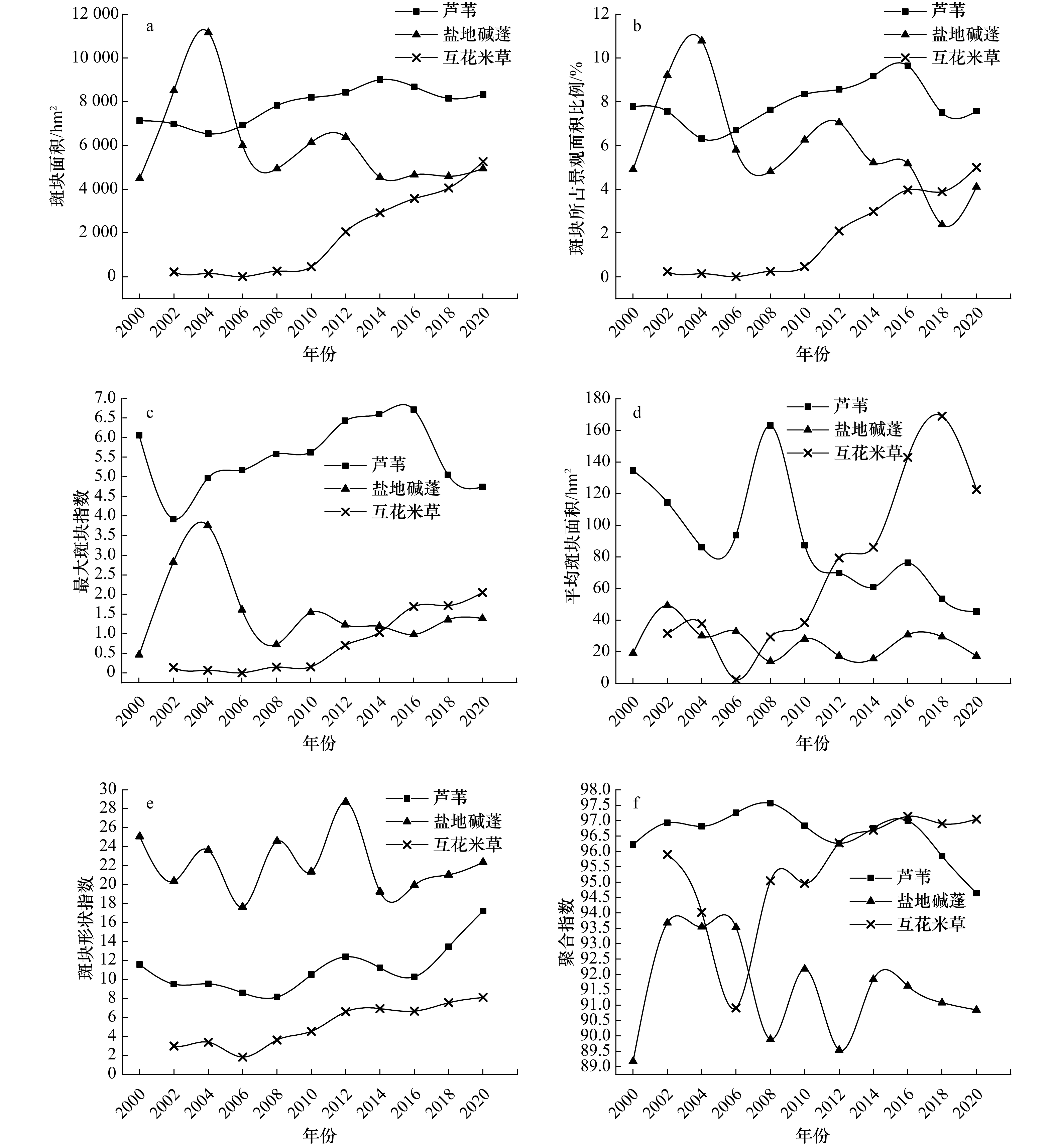
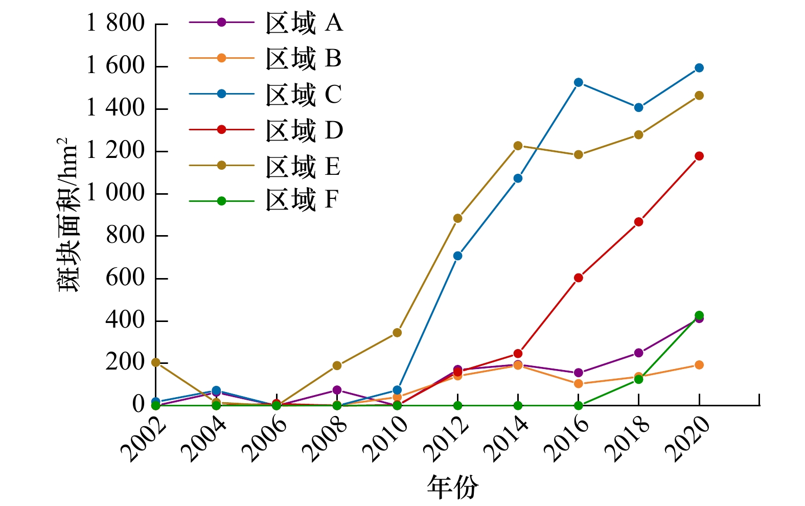
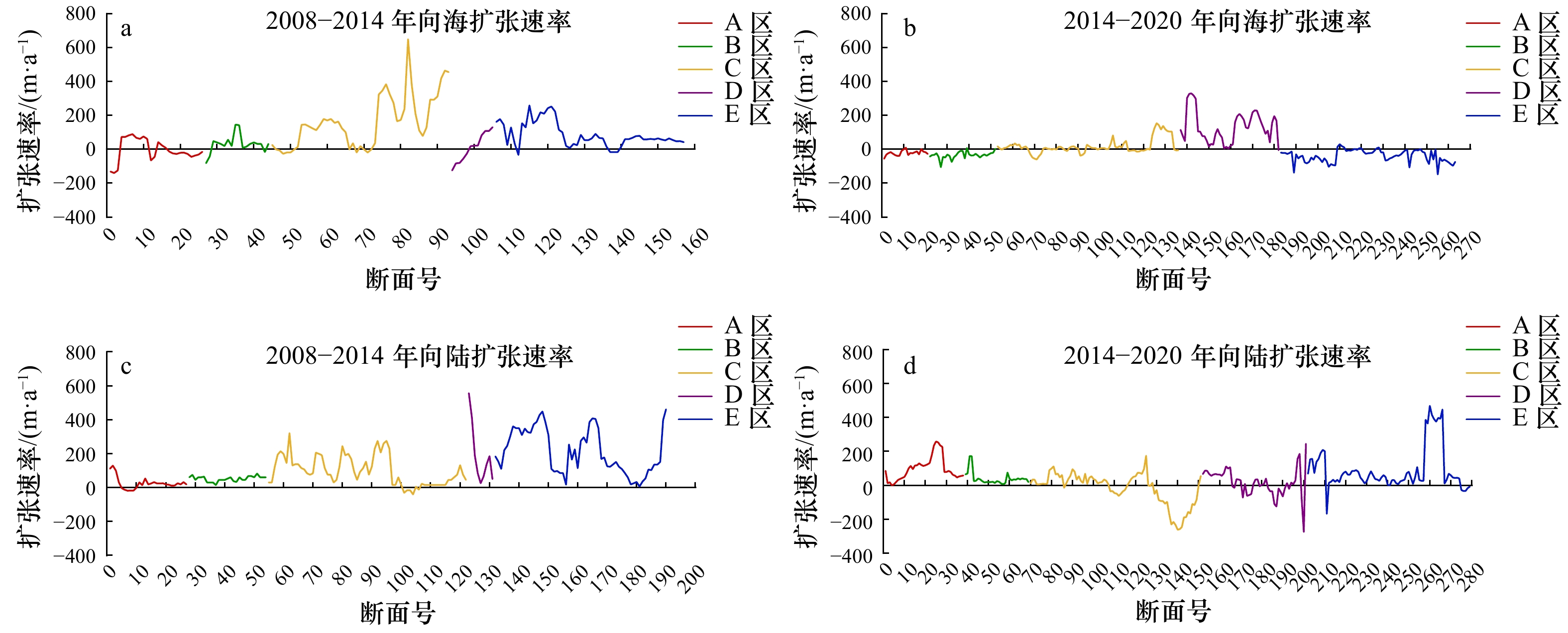
Figures(6) / Tables(7)


 DownLoad: