

Morphologic characteristics and controlling factors of the northeastern South China Sea canyon group
-
摘要: 海底峡谷在全球陆缘广泛分布,是浅海沉积物向深海运移的主要通道,对于理解深海浊流触发机制、深海沉积物的搬运模式、深海扇的发育历史和深海油气资源勘探等均具有重要意义。本文基于高分辨率高精度的多波束测深数据,首次对南海东北部海底峡谷体系进行了研究,精细刻画了高屏海底峡谷、澎湖海底峡谷、台湾浅滩南海底峡谷和东沙海底峡谷等4条大型海底峡谷的地貌特征并分析其发育控制因素。海底坡度、构造运动、海山与海丘是影响南海东北部峡谷群走向与特征的重要因素,其中,海底坡度对于峡谷上游多分支与“V”字特征有显著的控制作用;构造运动是控制高屏海底峡谷走向的因素,澎湖海底峡谷的走向则与菲律宾海板块与欧亚板块碰撞有关,东沙海底峡谷的走向则与东沙运动相关,台湾浅滩南海底峡谷上段受NW向断裂构造的控制;海山的阻挡作用造成峡谷局部走向和特征改变。海底峡谷群输送大量陆源沉积物到深海盆并形成大面积的沉积物波,海山和沉积物波的发育导致东沙海底峡谷下段“回春”和转向。Abstract: Submarine canyons are widely distributed on global continental margins, they are the main channels for sediment transport from shallow sea to deep sea. Submarine canyons are of great significance for understanding the triggering mechanism of turbidity currents, the transport pattern of sediments, the evolution of deep-sea/abysmal fans, and the exploration of oil and gas resources in deep sea. Based on high-resolution multi-beam bathymetric data, this paper studies the large submarine canyon group in the northeast of the South China Sea. The morphologic characteristics and controlling factors of the four large submarine canyons, the Kaoping, the Penghu, the South Taiwan Bank and the Dongsha submarine canyons, are described in detail. Seabed slope, tectonic movement, the development of seamounts and seaknolls are important factors affecting the orientation and characteristics of the Northeastern South China Sea Canyon Group. Seabed slope has an important influence on the multi-branch and "V"-shape of the upper reaches of the canyon. The orientation of the Kaoping submarine canyon is controlled by tectonic movement, the orientation of the Penghu submarine canyon is related to the collision between the Philippine Sea Plate and the South China Sea Plate, the orientation of the Dongsha submarine canyon is related to the Dongsha tectonic movement, and the upper reaches of the South Taiwan Bank submarine canyon is controlled by the NW-SE faults. The blocking effect of the seamounts changes the local orientation and morphologic characteristics of the submarine canyons. And the submarine canyon group acts as a channel to transport large amounts of terrigenous sediments to the deep-sea basin and form a large scale of sediment waves, while the development of seamounts and sediment waves leads to the "rejuvenation" and steering of the lower reaches of the Dongsha submarine canyon.
-

图 1 南海东北部海底峡谷与断裂系统(a)(断裂根据文献[18]修改)和海底峡谷多波束地形(b)
①高屏海底峡谷,②澎湖海底峡谷,③台湾浅滩南海底峡谷,④东沙海底峡谷,⑤神狐峡谷群,⑥珠江口外海底峡谷
Fig. 1 Submarine canyons and faults in the northeastern South China Sea (a, faults modified according to reference [18]), and multi-beam bathymetric of the submarine canyons (b)
①Kaoping submarine canyon, ②Penghu submarine canyon, ③South Taiwan Bank submarine canyon, ④Dongsha submarine canyon, ⑤Shenhu submarine canyon group, ⑥Zhujiang River submarine canyon

图 2 高屏海底峡谷地形
红色实线为峡谷主轴,黑色虚线为地形剖面位置
Fig. 2 Bathymetric of the Kaoping submarine canyon
The red line is the main axis of the canyon, and the black dashed lines are the locations of bathymetric profiles

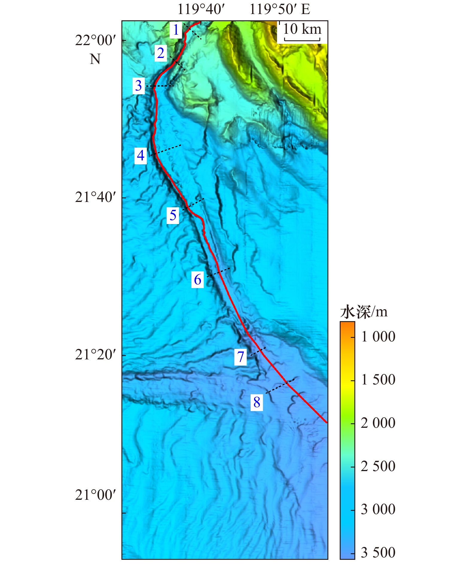
图 4 澎湖海底峡谷地形
红色实线为峡谷主轴,黑色虚线为地形剖面位置
Fig. 4 Bathymetric of the Penghu submarine canyon
The red line is the main axis of the canyon, and the black dashed lines are the locations of bathymetric profiles


图 6 台湾浅滩南海底峡谷地形
红色实线为峡谷主轴,黑色虚线为地形剖面位置
Fig. 6 Bathymetric of the South Taiwan Bank submarine canyon
The red line is the main axis of the canyon, and the black dashed lines are the locations of bathymetric profiles


图 8 东沙海底峡谷地形
红色实线为峡谷主轴,黑色虚线为地形剖面位置,A-A′及B-B′为多道地震剖面位置
Fig. 8 Bathymetric of the Dongsha submarine canyon
The red line is the main axis of the canyon, the black dashed lines are the locations of bathymetric profiles, A-A′ and B-B′ are the locations of multi-channel seismic profiles


-
[1] Shepard F P. Submarine Geology[M]. New York: Harper & Row, 1963. [2] Shepard F P. Submarine canyons[J]. Earth-Science Reviews, 1949, 8(1): 1−12. [3] 韩喜彬, 李家彪, 龙江平, 等. 我国海底峡谷研究进展[J]. 海洋地质前沿, 2010, 26(2): 41−48.Han Xibin, Li Jiabiao, Long Jiangping, et al. Development of research on submarine canyon in China[J]. Marine Geology Letters, 2010, 26(2): 41−48. [4] Lewis K B, Barnes P M. Kaikoura Canyon, New Zealand: active conduit from near-shore sediment zones to trench-axis channel[J]. Marine Geology, 1999, 162(1): 39−69. doi: 10.1016/S0025-3227(99)00075-4 [5] Posamentier H W, Jervey M T, Vail P R. Eustatic controls on clastic deposition I—conceptual framework[C]//Sea-Level Changes—An Integrated Approach, SEPM Special Publication. 1988. [6] Antobreh A A, Krastel S. Morphology, seismic characteristics and development of Cap Timiris Canyon, offshore Mauritania: A newly discovered canyon preserved-off a major arid climatic region[J]. Marine and Petroleum Geology, 2006, 23(1): 37−59. doi: 10.1016/j.marpetgeo.2005.06.003 [7] Pickering K, Coleman J, Cremer M, et al. A high sinuosity, laterally migrating submarine fan channel-levee-overbank: results from DSDP Leg 96 on the Mississippi Fan, Gulf of Mexico[J]. Marine and Petroleum Geology, 1986, 3(1): 3−18. doi: 10.1016/0264-8172(86)90052-8 [8] 徐景平. 海底浊流研究百年回顾[J]. 中国海洋大学学报: 自然科学版, 2014, 44(10): 98−105.Xu Jingping. Turbidity current research in the past century: an overview[J]. Periodical of Ocean University of China, 2014, 44(10): 98−105. [9] Carter L, Milliman J D, Talling P J, et al. Near-synchronous and delayed initiation of long run-out submarine sediment flows from a record-breaking river flood, offshore Taiwan[J]. Geophysical Research Letters, 2012, 39(12): 12603. [10] 吴自银, 阳凡林, 李守军, 等. 高分辨率海底地形地貌–可视计算与科学应用[M]. 北京: 科学出版社, 2017.Wu Ziyin, Yang Fanlin, Li Shoujun, et al. High Resolution Submarine Geomorphology: Visual Computing and Scientific Applications[M]. Beijing: Science Press, 2017. [11] 吴自银, 阳凡林, 罗孝文, 等. 高分辨率海底地形地貌—探测处理理论与技术[M]. 北京: 科学出版社, 2017.Wu Ziyin, Yang Fanlin, Luo Xiaowen, et al. High Resolution Submarine Geomorphology: Detection Processing Theory and Technology[M]. Beijing: Science Press, 2017. [12] Taylor B, Smoot N C. Morphology of Bonin fore-arc submarine canyons[J]. Geology, 1984, 12(12): 724−727. doi: 10.1130/0091-7613(1984)12<724:MOBFSC>2.0.CO;2 [13] 吴自银, 王小波, 金翔龙, 等. 冲绳海槽弧后扩张证据及关键问题探讨[J]. 海洋地质与第四纪地质, 2004, 24(3): 67−76.Wu Ziyin, Wang Xiaobo, Jin Xianglong, et al. The evidences of the backarc spreading and discussion on the key issues in the Okinawa Trough[J]. Marine Geology & Quaternary Geology, 2004, 24(3): 67−76. [14] Wu Ziyin, Li Jiabiao, Jin Xianglong, et al. Distribution, features, and influence factors of the submarine topographic boundaries of the Okinawa Trough[J]. Science China Earth Sciences, 2014, 57(8): 1885−1896. doi: 10.1007/s11430-013-4810-3 [15] Jobe Z R, Lowe D R, Uchytil S J. Two fundamentally different types of submarine canyons along the continental margin of Equatorial Guinea[J]. Marine and Petroleum Geology, 2011, 28(3): 843−860. doi: 10.1016/j.marpetgeo.2010.07.012 [16] Yin Shaoru, Lin Lin, Pope E L, et al. Continental slope-confined canyons in the Pearl River Mouth Basin in the South China Sea dominated by erosion, 2004−2018[J]. Geomorphology, 2019, 344: 60−74. doi: 10.1016/j.geomorph.2019.07.016 [17] 赵家斌, 钟广法. 构造活动对海底峡谷地貌形态的影响[J]. 海洋地质前沿, 2018(12): 1−13.Zhao Jiabin, Zhong Guangfa. A review on geomorphic response of submarine canyons to tectonic deformation[J]. Marine Geology Frontiers, 2018(12): 1−13. [18] 丁巍伟, 李家彪, 李军. 南海北部陆坡海底峡谷形成机制探讨[J]. 海洋学研究, 2010, 28(1): 26−31. doi: 10.3969/j.issn.1001-909X.2010.01.004Ding Weiwei, Li Jiabiao, Li Jun. Forming mechanism of the submarine canyon on the north slope of the South China Sea[J]. Journal of Marine Sciences, 2010, 28(1): 26−31. doi: 10.3969/j.issn.1001-909X.2010.01.004 [19] Zhang Yanwei, Liu Zhifei, Zhao Yulong, et al. Long-term in situ observations on typhoon-triggered turbidity currents in the deep sea[J]. Geology, 2018, 46(8): 675−678. doi: 10.1130/G45178.1 [20] 苏明, 解习农, 王振峰, 等. 南海北部琼东南盆地中央峡谷体系沉积演化[J]. 石油学报, 2013, 34(3): 467−478. doi: 10.7623/syxb201303007Su Ming, Xie Xinong, Wang Zhenfeng, et al. Sedimentary evolution of the central canyon system in Qiongdongnan Basin, northern South China Sea[J]. Acta Petrolei Sinica, 2013, 34(3): 467−478. doi: 10.7623/syxb201303007 [21] 丁巍伟, 李家彪, 李军, 等. 南海珠江口外海底峡谷形成的控制因素及过程[J]. 热带海洋学报, 2013, 32(6): 63−72. doi: 10.3969/j.issn.1009-5470.2013.06.010Ding Weiwei, Li Jiabiao, Li Jun, et al. Formation process and controlling factors of the Pearl River Canyon in the South China Sea[J]. Journal of Tropical Oceanography, 2013, 32(6): 63−72. doi: 10.3969/j.issn.1009-5470.2013.06.010 [22] 殷绍如, 王嘹亮, 郭依群, 等. 东沙海底峡谷的地貌沉积特征及成因[J]. 中国科学: 地球科学, 2015, 58(6): 971−985. doi: 10.1007/s11430-014-5044-8Yin Shaoru, Wang Liaoliang, Guo Yiqun, et al. Morphology, sedimentary characteristics, and origin of the Dongsha submarine canyon in the northeastern continental slope of the South China Sea[J]. Science China: Earth Science, 2015, 58(6): 971−985. doi: 10.1007/s11430-014-5044-8 [23] 徐尚, 王英民, 彭学超, 等. 台湾峡谷的成因及其对沉积的控制[J]. 中国科学: 地球科学, 2014, 44(9): 1913−1924.Xu Shang, Wang Yingmin, Peng Xuechao, et al. Origin of Taiwan Canyon and its effects on deepwater sediment[J]. Science China: Earth Science, 2014, 44(9): 1913−1924. [24] Yu H S, Chang J F. The Penghu submarine canyon off southwestern Taiwan: Morphology and origin[J]. Terrestrial, Atmospheric and Oceanic Sciences, 2002, 13(4): 547−562. doi: 10.3319/TAO.2002.13.4.547(O) [25] Liu C S, Lundberg N, Reed D L, et al. Morphological and seismic characteristics of the Kaoping Submarine Canyon[J]. Marine Geology, 1993, 111(1/2): 93−108. [26] Chiang C S, Yu H S. Morphotectonics and incision of the Kaoping submarine canyon, SW Taiwan orogenic wedge[J]. Geomorphology, 2006, 80(3/4): 199−213. [27] Chiang C S, Yu H. Evidence of hyperpycnal flows at the head of the meandering Kaoping Canyon off SW Taiwan[J]. Geo-Marine Letters, 2008, 28(3): 161−169. doi: 10.1007/s00367-007-0098-7 [28] Yu H S, Chiang C S, Shen Sumin. Tectonically active sediment dispersal system in SW Taiwan margin with emphasis on the Gaoping (Kaoping) Submarine Canyon[J]. Journal of Marine Systems, 2009, 76(4): 369−382. doi: 10.1016/j.jmarsys.2007.07.010 [29] Zhao Dineng, Wu Ziyin, Zhou Jieqiong, et al. A new method of automatic SVP optimization based on MOV algorithm[J]. Marine Geodesy, 2015, 38(3): 225−240. doi: 10.1080/01490419.2015.1006798 [30] Zhou Jieqiong, Wu Ziyin, Jin Xianlong, et al. Observations and analysis of giant sand wave fields on the Taiwan Banks, northern South China Sea[J]. Marine Geology, 2018, 406: 132−141. doi: 10.1016/j.margeo.2018.09.015 [31] 杜德莉. 台西南盆地地质构造特征及油气远景[J]. 海洋地质与第四纪地质, 1991, 11(3): 21−33.Du Deli. Characteristics of geologic structure and hydrocarbon potential of the southwest Taiwan basin[J]. Marine Geology & Quaternary Geology, 1991, 11(3): 21−33. [32] 易海, 钟广见, 马金凤. 台西南盆地新生代断裂特征与盆地演化[J]. 石油实验地质, 2007, 29(6): 560−564. doi: 10.3969/j.issn.1001-6112.2007.06.006Yi Hai, Zhong Guangjian, Ma Jinfeng. Fracture characteristics and basin evolution of the Taixinan basin in Cenozoic[J]. Petroleum Geology & Experiment, 2007, 29(6): 560−564. doi: 10.3969/j.issn.1001-6112.2007.06.006 [33] Taylor B, Hayes D E. Origin and history of the South China Sea basin[M]//Hayes D E. The Tectonic and Geologic Evolution of Southeast Asian Seas and Islands: Part 2. Washington, D.C.: Geophysical Monograph Series, 1983, 27: 23−56. [34] Briais A, Patriat P, Tapponnier P. Updated interpretation of magnetic anomalies and seafloor spreading stages in the South China Sea: Implications for the Tertiary tectonics of Southeast Asia[J]. Journal of Geophysical Research: Solid Earth, 1993, 98(B4): 6299−6328. doi: 10.1029/92JB02280 [35] Hutchison C S. Marginal basin evolution: the southern South China Sea[J]. Marine and Petroleum Geology, 2004, 21(9): 1129−1148. doi: 10.1016/j.marpetgeo.2004.07.002 [36] 栾锡武, 彭学超, 王英民, 等. 南海北部陆架海底沙波基本特征及属性[J]. 地质学报, 2010, 84(2): 233−245.Luan Xiwu, Peng Xuechao, Wang Yingming, et al. Characteristics of sand waves on the northern South China Sea shelf and its formation[J]. Acta Geologica Sinica, 2010, 84(2): 233−245. [37] 黄镇国. 台湾板块构造与环境演变[M]. 北京: 海洋出版社, 1995.Huang Zhenguo. Plate Tectonics and Environmental Evolution in Taiwan[M]. Beijing: China Ocean Press, 1995. [38] 张开毕, 徐维光, 陈淑华, 等. 台湾区域地质概论[J]. 福建地质, 2017, 36(2): 79−93. doi: 10.3969/j.issn.1001-3970.2017.02.001Zhang Kaibi, Xu Weiguang, Chen Shuhua, et al. Geological survey in Taiwan area[J]. Geology of Fujian, 2017, 36(2): 79−93. doi: 10.3969/j.issn.1001-3970.2017.02.001 [39] Zheng Zhuo, Li Qianyu. Vegetation, climate, and sea level in the Past 55, 000 years, Hanjiang delta, southeastern China[J]. Quaternary Research, 2000, 53(3): 330−340. doi: 10.1006/qres.1999.2126 [40] 黄慈流, 钟建强. 南海东北部及其邻区新生代构造事件[J]. 热带海洋, 1994, 13(1): 55−62.Huang Ciliu, Zhong Jianqiang. Tectonic events in the Cenozoic era in the northeast area of south China sea and its neighboring regions[J]. Tropic Oceanography, 1994, 13(1): 55−62. [41] 赵淑娟, 吴时国, 施和生, 等. 南海北部东沙运动的构造特征及动力学机制探讨[J]. 地球物理学进展, 2012, 27(3): 1008−1019. doi: 10.6038/j.issn.1004-2903.2012.03.022Zhao Shujuan, Wu Shiguo, Shi Hesheng, et al. Structures and dynamic mechanism related to the Dongsha movement at the northern margin of South China Sea[J]. Progress in Geophysics, 2012, 27(3): 1008−1019. doi: 10.6038/j.issn.1004-2903.2012.03.022 [42] Liu C S, Huang I L, Teng L S. Structural features off southwestern Taiwan[J]. Marine Geology, 1997, 137(3/4): 305−319. [43] 黄任亿. 台灣西南海域高屏陸坡盆地及澎湖海底峽谷—水道系統的沉積作用及演化[D]. 台北: 台湾大学海洋研究所, 2006.Huang Renyi. Sedimentation and evolution of Kaoping slope basin and penghu submarine canyon—channel system off southwest Taiwan[D]. Taipei: Institute of Oceanography, Taiwan University, 2006. [44] Organization I H. Standardization of Undersea Feature Names[Z]. International Hydrographic Organization Monaco, 2008. [45] Wynn R B, Stow D A V. Classification and characterisation of deep-water sediment waves[J]. Marine Geology, 2002, 192(1/3): 7−22. -

 下载:
下载:


 点击查看大图
计量
- 文章访问数: 254
- HTML全文浏览量: 84
- PDF下载量: 10
- 被引次数: 0
