

Morphodynamic evolution of the Biandan Shoal in the Changjiang River Estuary
-
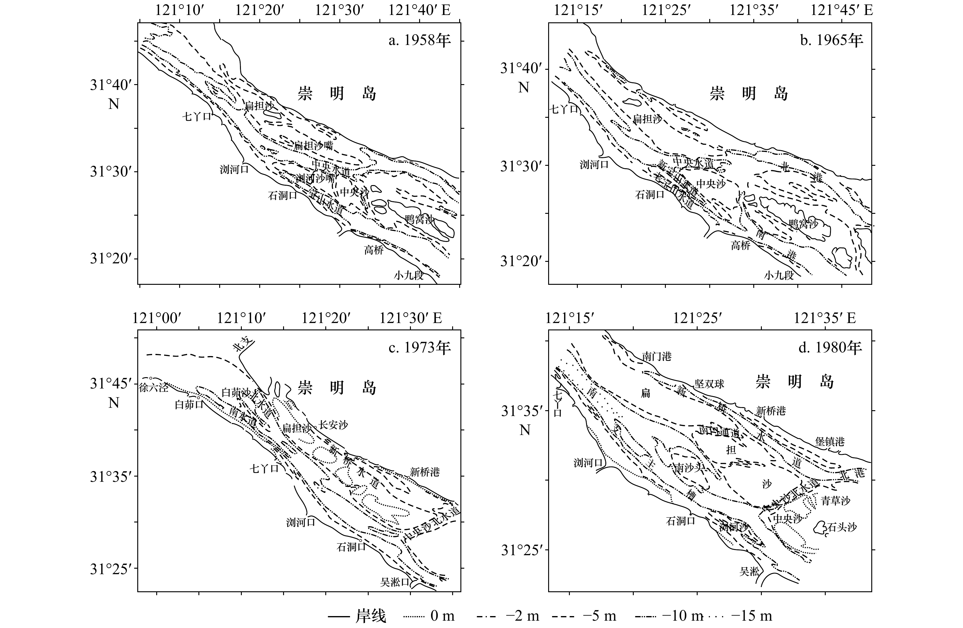
摘要: 河口浅滩不仅为人类提供宝贵湿地资源,而且是调控河势演变的重要因素。研究河口浅滩动力地貌演变规律对航道整治、湿地生态开发及岸堤防护等具有重要价值。本文利用最近150多年的长江口历史海图资料、实测水深与水文泥沙数据,分析长江口南支最大的浅滩—扁担沙动力地貌演变格局及其变化机制。结果表明:(1) 1860−2016年期间,扁担沙反复历经淤积−冲刷−淤积,浅滩由最初水下阴滩发育出露而形成纺锤状沙体,随后演变为细长扁担状,沙尾切滩成爪状沙体,下扁担沙则伴随爪状缝隙被不断填充而淤长;(2)自1954年洪水到目前,扁担沙−2 m、−5 m等深线包络的面积与体积整体上均呈现增长态势,其中面积年均增长率分别为0.88 km2/a和0.81 km2/a,体积年均增长率分别为1.3×106 m3/a和5×106 m3/a;扁担沙浅滩在不同时期冲淤变化不同,其中1998年出现大幅度冲刷,平均冲刷厚度达到1.4 m;(3)扁担沙体积变化和长江入海泥沙的增减无直接联系,但与入海径流量的变化密切相关;(4)白茆沙“南强北弱”的河势、南北港分流工程以及东风西沙水库的建立导致扁担沙向北推移。Abstract: Estuary shoal not only provides valuable wetland resources for humans, and also plays an important role in adjusting evolution of river regime. It is of vital significance to understand the morphodynamic evolution of estuary shoal for channel regulation, wetland development and dike protection. Therefore, based on historical chart for 150 years, bathymetric data, hydrology and sediment data, the morphodynamic processes and associated evolution mechanism of the Biandan Shoal, the biggest shoal in the South Branch were analyzed. The main results show that: (1) During 1860−2016, the Biandan Shoal has experienced the process of “deposition-erosion-deposition” repetitively; and its morphodynamic status was formed from original submerged shoal to spindle-shaped configuration above water surface; subsequently, the appearance was evolved to be relatively slim shoulder pole morphology with tail which was broken into a claw-like status; the lower part was gradually accreted due to the filled tidal creek among the claw-like configuration. (2) There is upward trend in both area and volume of the Biandan Shoal above −2 m, −5 m, respectively. The average annual increased rate of area above −2 m and −5 m is 0.88 km2/a and 0.81 km2/a, and corresponding increased volume rate is 1.3×10⁶ m3/a and 5×10⁶ m3/a, respectively. Meanwhile, extremely erosion occurred in 1998 with average thickness of 1.4 m. (3) While yearly sediment discharge from upstream has insignificant impact on the Biandan Shoal, water discharge could be responsible for the erosion/accretion of the Biandan Shoal; (4) The hydrology condition of strong south and weak north of the Baimao Shoal, the project of distributary reach of south and north channels, and the Dongfengxisha Reservoir directly caused the Biandan Shoal to move northward.
-

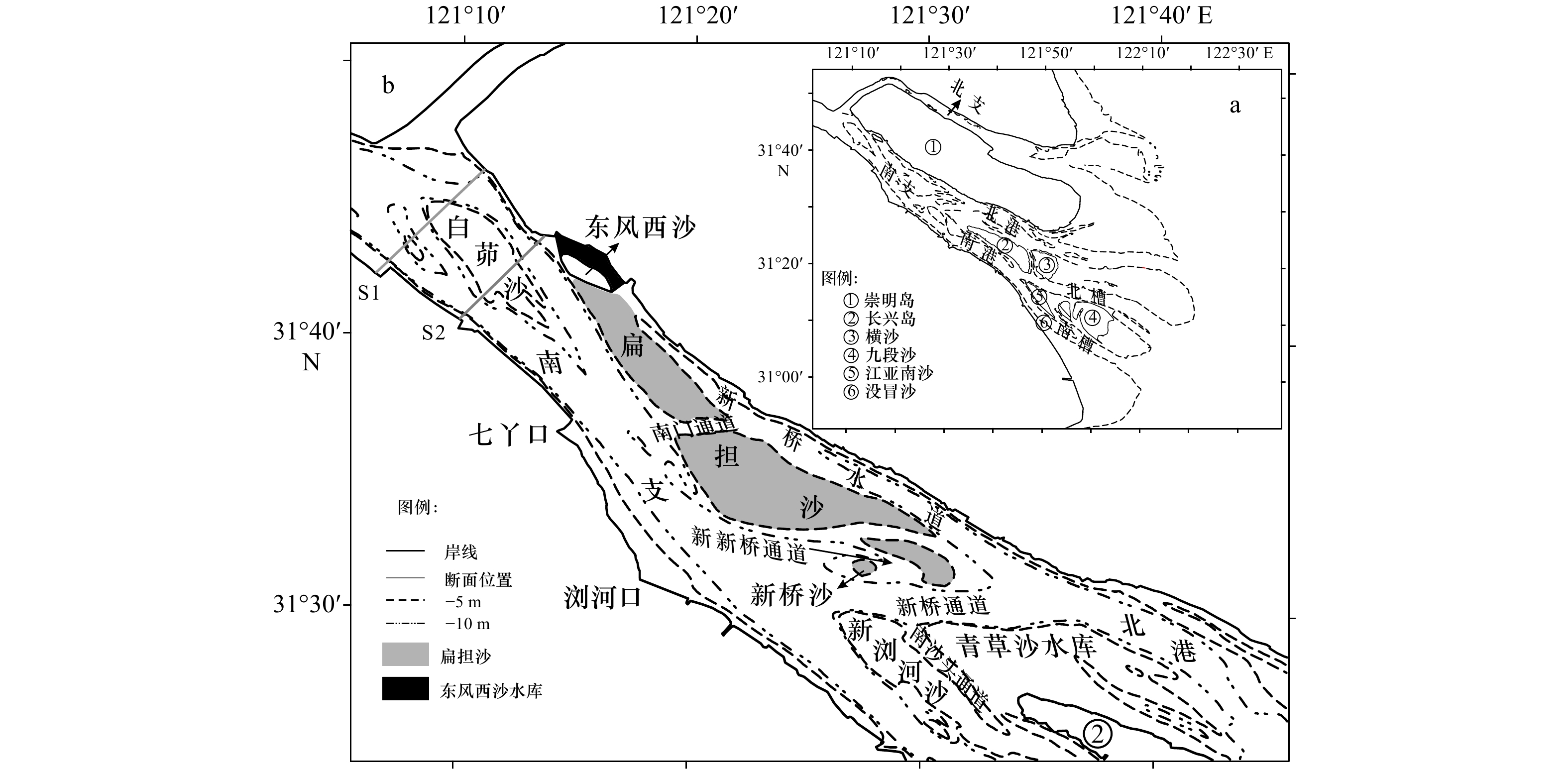
图 4 1958−2016年扁担沙−2 m与−5 m等深线形态变化状态
Fig. 4 Evolution of −2 m and −5 m isobaths of the Biandan Shoal from 1958 to 2016
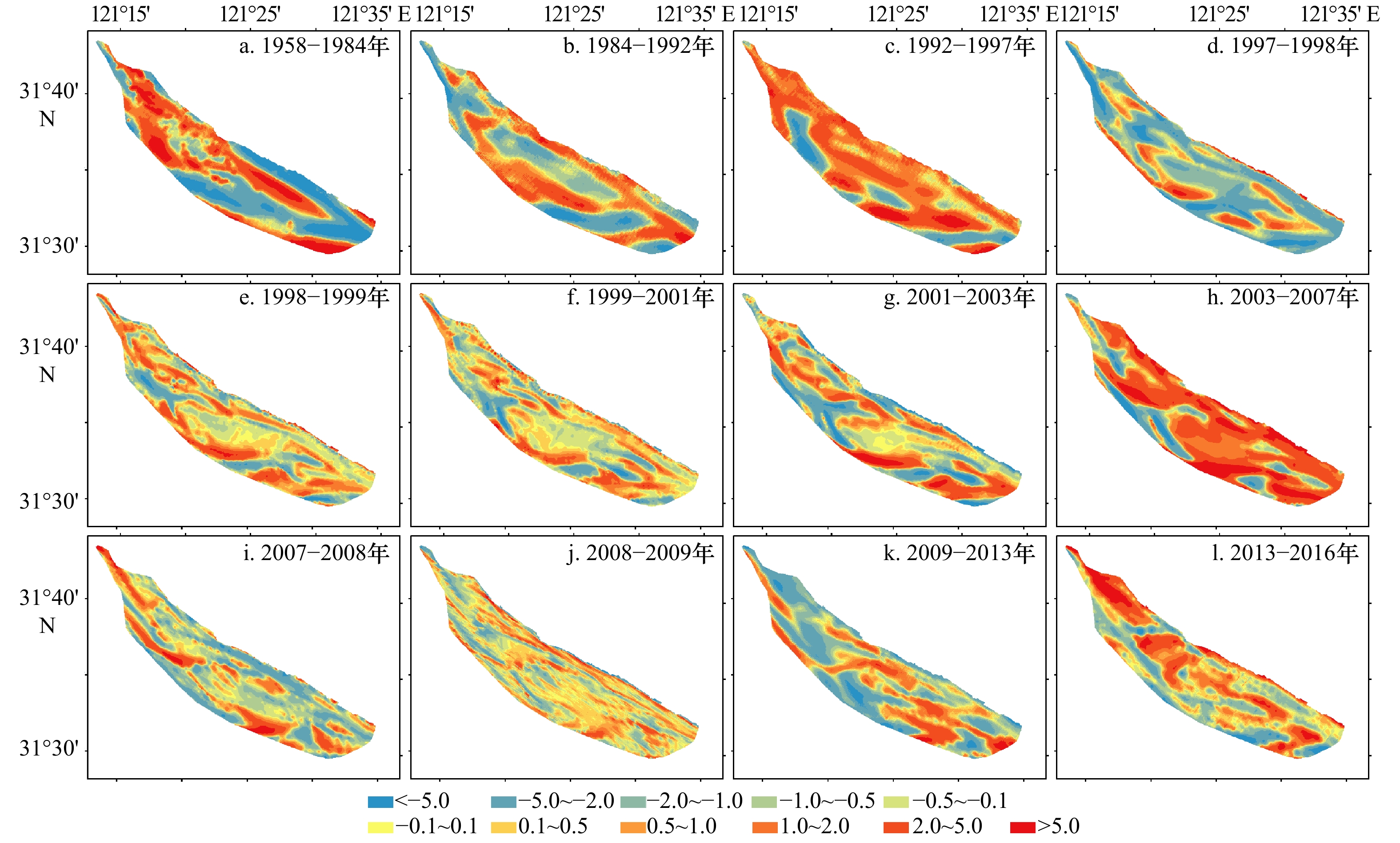
图 6 1958−2016年扁担沙冲淤变化(单位:m)
Fig. 6 Bathymetric changes of the Biandan Shoal during the different periods from 1958 to 2016 (unit: m)
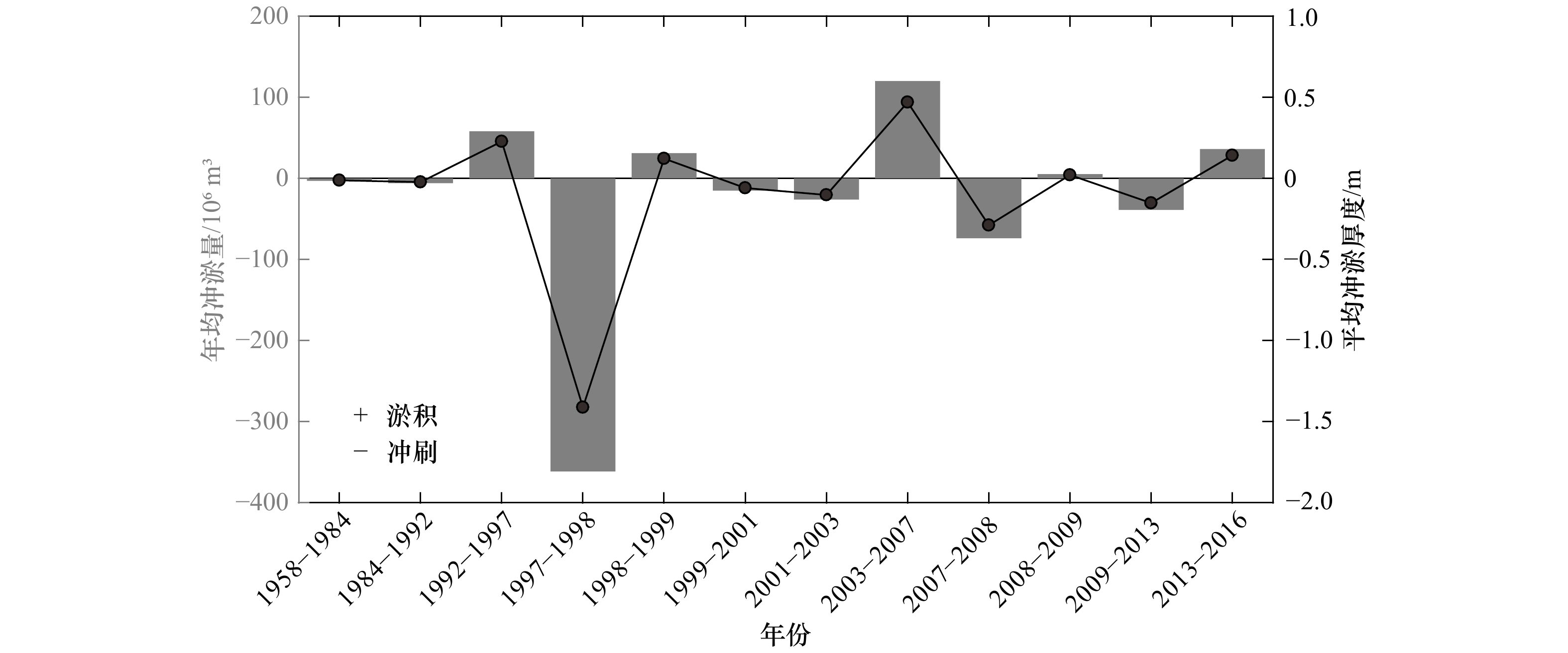
图 7 1958−2016年扁担沙年平均冲淤变化
Fig. 7 The yearly changes in accretion/erosion of the Biandan Shoal from 1958 to 2016
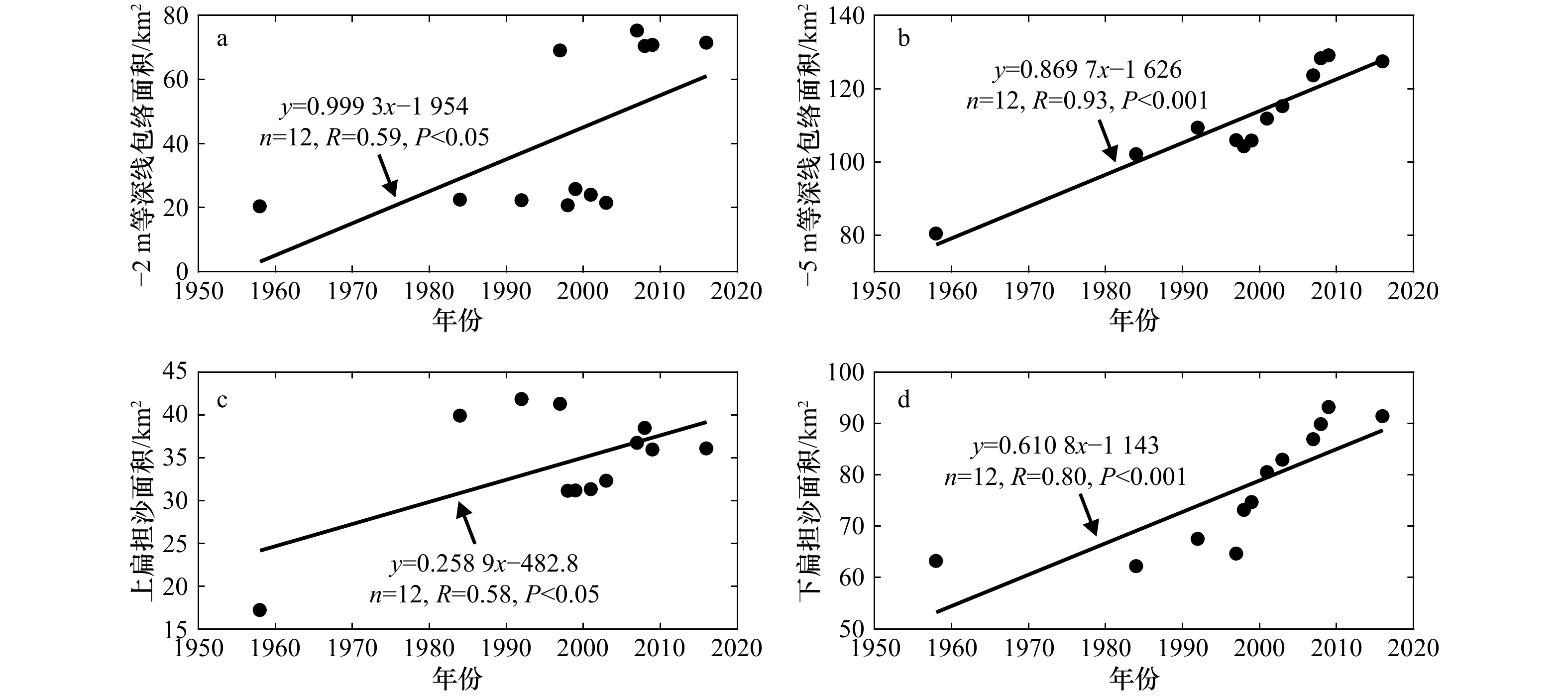
图 8 1958−2016年扁担沙面积变化状态
Fig. 8 Yearly variations in area of the Biandan Shoal from 1958 to 2016
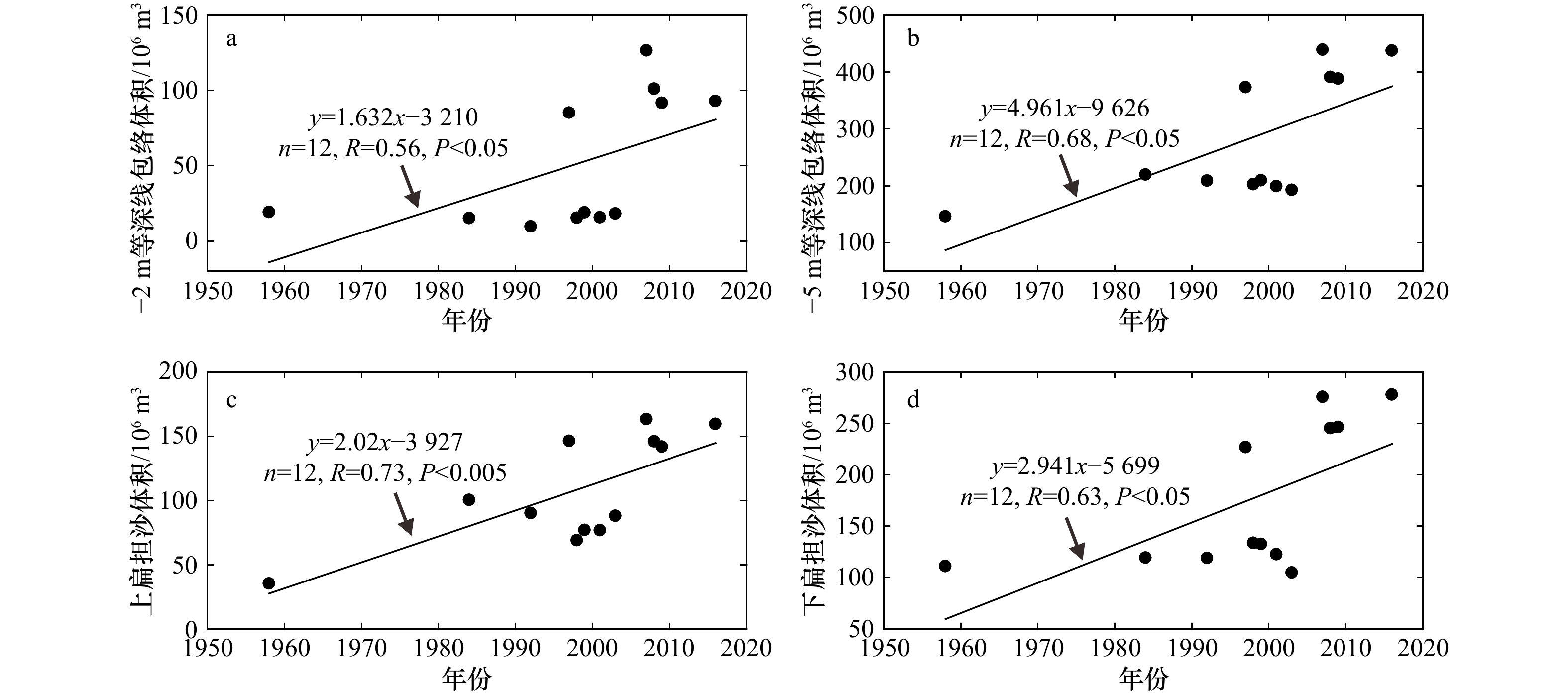
图 9 1958−2016年扁担沙体积变化状态
Fig. 9 Yearly variations in volume of the Biandan Shoal from 1958 to 2016
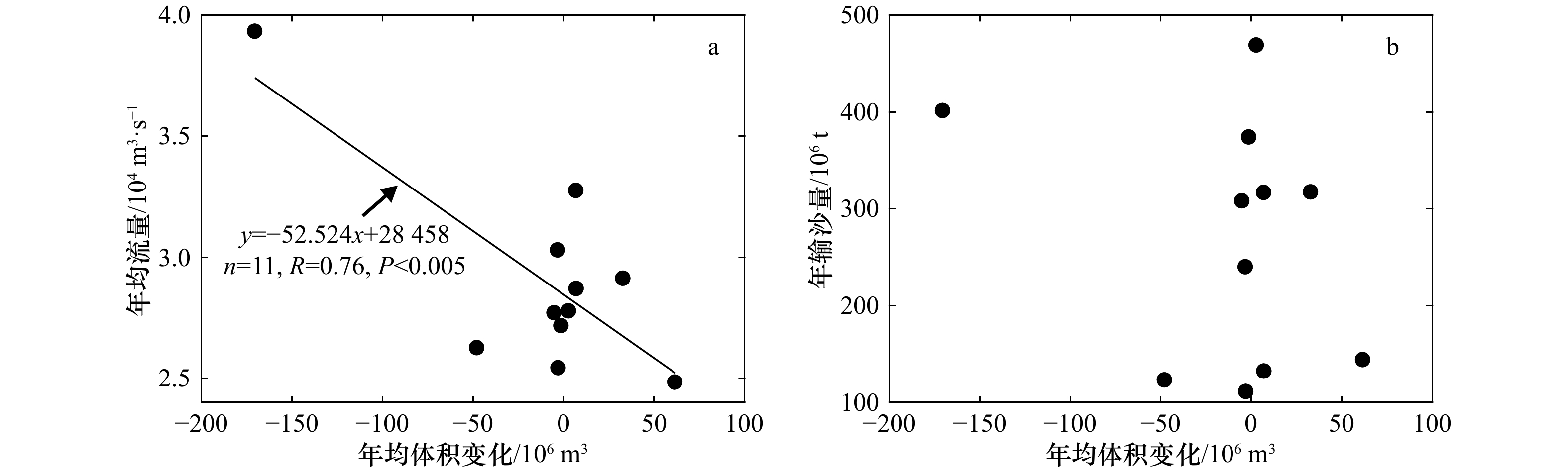
图 11 扁担沙年均体积变化与大通站年均流量、输沙量的关系
Fig. 11 Relations between yearly volume changes of the Biandan Shoal and yearly water and sediment discharges at the Datong Station
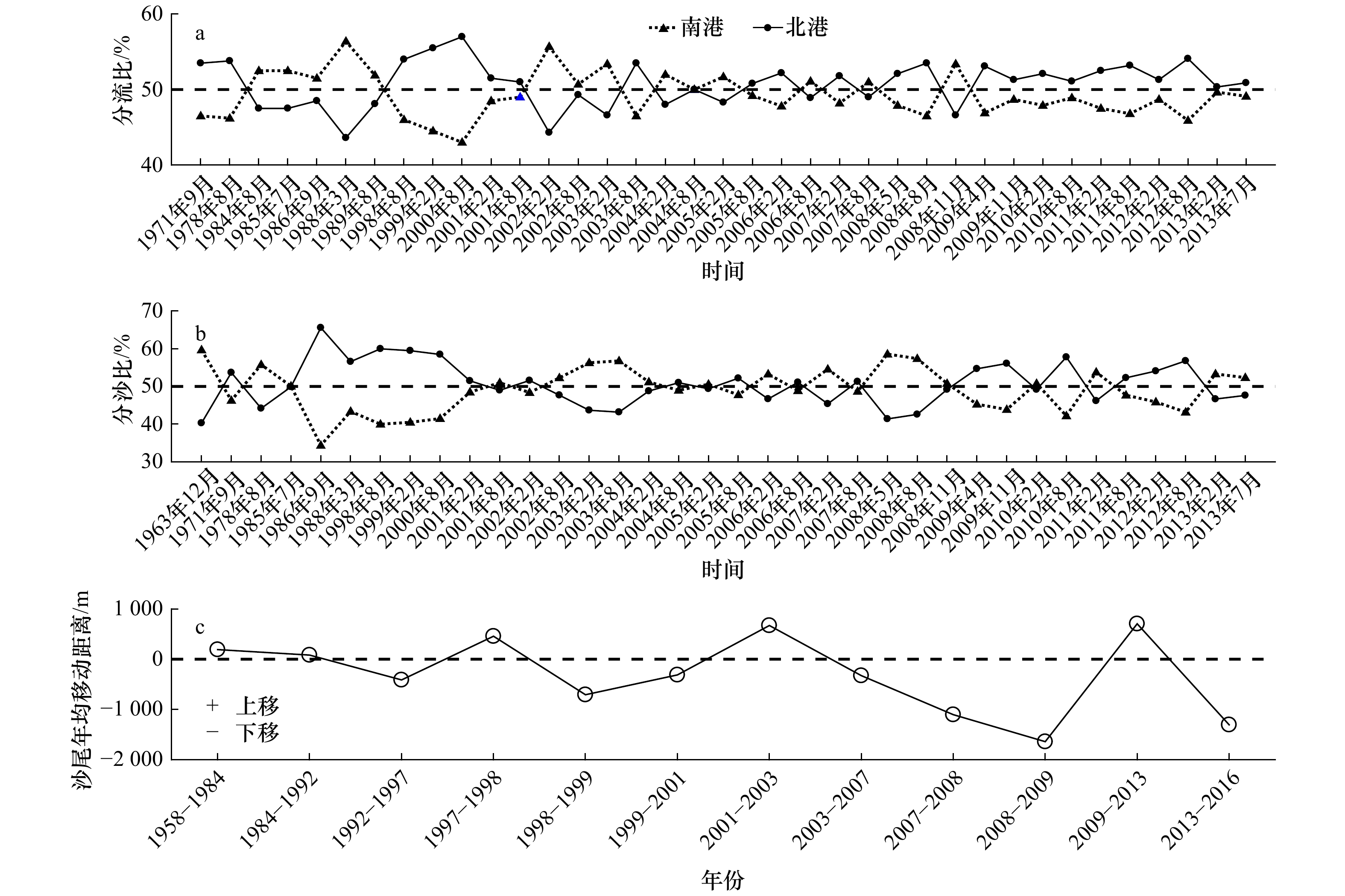
图 13 南北港分流口分流、分沙比和沙尾年均移动距离
Fig. 13 The water and sediment discharge ratios in the South Channel and North Channel
-
[1] Dyer K R, Christie M C, Wright E W. The classification of intertidal mudflats[J]. Continental Shelf Research, 2000, 20(10/11): 1039−1060. [2] Knaapen M A F. Sandbank occurrence on the Dutch continental shelf in the North Sea[J]. Geo-Marine Letters, 2009, 29(1): 17−24. doi: 10.1007/s00367-008-0105-7 [3] Kim S G. The evolution of coastal wetland policy in developed countries and Korea[J]. Ocean & Coastal Management, 2010, 53(9): 562−569. [4] Anthony E J, Brunier G, Besset M, et al. Linking rapid erosion of the Mekong River delta to human activities[J]. Scientific Reports, 2015, 5: 14745. doi: 10.1038/srep14745 [5] Dai Z J, Liu J T, Wen W. Morphological evolution of the South Passage in the Changjiang (Yangtze River) Estuary, China[J]. Quaternary International, 2015, 380-381: 314−326. doi: 10.1016/j.quaint.2015.01.045 [6] Wei W, Mei X F, Dai Z J, et al. Recent morphodynamic evolution of the largest uninhibited island in the Yangtze (Changjiang) Estuary during 1998-2014: influence of the anthropogenic interference[J]. Continental Shelf Research, 2016, 124: 83−94. doi: 10.1016/j.csr.2016.05.011 [7] Mei X F, Dai Z J, Wei W, et al. Secular bathymetric variations of the North Channel in the Changjiang (Yangtze) Estuary, China, 1880-2013: causes and effects[J]. Geomorphology, 2018, 303: 30−40. doi: 10.1016/j.geomorph.2017.11.014 [8] Kohsiek L H M, Buist H J, Bloks P, et al. Sedimentary processes on a sandy shoal in a Mesotidal Estuary[M]//Tide-Influenced Sedimentary Environments and Facies. Netherlands: Springer, 1988: 201-214. [9] 胡红兵, 程和琴, 胡方西, 等. 长江口第二、三代冲积岛浅滩演变特征分析[J]. 泥沙研究, 2004(6): 57−63. doi: 10.3321/j.issn:0468-155X.2004.06.011Hu Hongbing, Cheng Heqin, Hu Fangxi, et al. Evolution characteristics of the shoals of the second and third generation alluvial islands in the Changjiang Estuary[J]. Journal of Sediment Research, 2004(6): 57−63. doi: 10.3321/j.issn:0468-155X.2004.06.011 [10] Syvitski J P M, Kettner A J, Overeem I, et al. Sinking deltas due to human activities[J]. Nature Geoscience, 2009, 2(10): 681−686. doi: 10.1038/ngeo629 [11] Wei W, Dai Z J, Mei X F, et al. Shoal morphodynamics of the Changjiang (Yangtze) Estuary: influences from river damming, estuarine hydraulic engineering and reclamation projects[J]. Marine Geology, 2017, 386: 32−43. doi: 10.1016/j.margeo.2017.02.013 [12] Gao A, Yang S L, Li G, et al. Long-term morphological evolution of a tidal island as affected by natural factors and human activities, the Yangtze Estuary[J]. Journal of Coastal Research, 2010, 26(1): 123−131. [13] Angamuthu B, Darby S E, Nicholls R J. Impacts of natural and human drivers on the multi-decadal morphological evolution of tidally-influenced deltas[J]. Proceedings of the Royal Society A: Mathematical, Physical and Engineering Sciences, 2018, 474(2219): 20180396. doi: 10.1098/rspa.2018.0396 [14] 时连强, 李九发, 应铭, 等. 长江口没冒沙演变过程及其对水库工程的响应[J]. 长江流域资源与环境, 2006, 15(4): 458−464. doi: 10.3969/j.issn.1004-8227.2006.04.009Shi Lianqiang, Li Jiufa, Ying Ming, et al. Evolutional process in Meimaosha of the Yangtze River Estuary and its response to reservoir project[J]. Resources and Environment in the Yangtze Basin, 2006, 15(4): 458−464. doi: 10.3969/j.issn.1004-8227.2006.04.009 [15] 盛皓, 戴志军, 梅雪菲, 等. 长江口青草沙水库前沿河床演变与失稳风险研究[J]. 海洋工程, 2017, 35(2): 105−114.Sheng Hao, Dai Zhijun, Mei Xuefei, et al. Research on evolution and instability risk of the frontal river bed along the Qingcaosha Reservoir, Changjiang Estuary[J]. The Ocean Engineering, 2017, 35(2): 105−114. [16] 谢华亮, 戴志军, 左书华, 等. 1959−2013年长江河口南槽动力地貌演变过程[J]. 海洋工程, 2015, 33(5): 51−59.Xie Hualiang, Dai Zhijun, Zuo Shuhua, et al. Morphodynamic processes of the south passage of the Yangtze Estuary (1959−2013)[J]. The Ocean Engineering, 2015, 33(5): 51−59. [17] 茅志昌, 虞志英, 徐海根. 上海潮滩研究[M]. 上海: 华东师范大学出版社, 2014.Mao Zhichang, Yu Zhiying, Xu Haigen. Research on Shanghai Tidal Flat[M]. Shanghai: East China Normal University Press, 2014. [18] 陈吉余. 中国河口海岸研究与实践[M]. 北京: 高等教育出版社, 2007.Chen Jiyu. Estuarine and Coastal Research and Practice in China[M]. Beijing: Higher Education Press, 2007. [19] 恽才兴. 长江河口近期演变基本规律[M]. 北京: 海洋出版社, 2004.Yun Caixing. Recent Developments of the Changjiang Estuary[M]. Beijing: China Ocean Press, 2004. [20] 郭建强. 长江河口外沙里泓地形的形成演变及其在河口整治开发中的作用[D]. 上海: 华东师范大学, 2008.Guo Jianqiang. The formative processes and application in estuarine regulation and exploiture of out-bar and inner-stream topographty in Changjiang Estuary[D]. Shanghai: East China Normal University, 2008. [21] Dai Z J, Liu J T, Wei W, et al. Detection of the Three Gorges Dam influence on the Changjiang (Yangtze River) submerged delta[J]. Scientific Reports, 2015, 4: 6600. doi: 10.1038/srep06600 [22] Yang S L, Milliman J D, Li P, et al. 50, 000 dams later: erosion of the Yangtze River and its delta[J]. Global and Planetary Change, 2011, 75(1/2): 14−20. [23] Dai Z J, Mei X F, Darby S E, et al. Fluvial sediment transfer in the Changjiang (Yangtze) river-estuary depositional system[J]. Journal of Hydrology, 2018, 566: 719−734. doi: 10.1016/j.jhydrol.2018.09.019 [24] 夏云峰, 曹民雄, 陈雄波. 长江下游三沙(福姜沙、通州沙、白茆沙)水道演变分析及深水航道整治设想[J]. 泥沙研究, 2001(3): 57−61. doi: 10.3321/j.issn:0468-155X.2001.03.010Xia Yunfeng, Cao Mingxiong, Chen Xiongbo. Formation analysis and regulation plan for dredging channel of the three sand shoals (Fujiang Sand Shoal, Tongzhou Sand Shoal and Baimao Sand Shoal) on the lower Yangtze River[J]. Journal of Sediment Research, 2001(3): 57−61. doi: 10.3321/j.issn:0468-155X.2001.03.010 [25] 刘怀汉, 袁达全, 裴金林, 等. 长江下游白茆沙水道航道整治对策[J]. 水运工程, 2013(S1): 165−172.Liu Huaihan, Yuan Daquan, Pei Jinlin, et al. Waterway regulation countermeasures of Baimaosha waterway in the lower reach of the Yangtze River[J]. Port & Waterway Engineering, 2013(S1): 165−172. [26] 王永红. 长江河口涨潮槽的形成机理与动力沉积特征[D]. 上海: 华东师范大学, 2003.Wang Yonghong. Reformation mechanism and features of dynamic sediment in flood channels of the Changjiang Estuary[D]. Shanghai: East China Normal University, 2003. [27] 徐骏, 王珏. 长江口白茆沙汊道段近期河道演变分析[J]. 水利科技与经济, 2015, 21(11): 87−90. doi: 10.3969/j.issn.1006-7175.2015.11.030Xu Jun, Wang Jue. Analysis on recent evolution of Baimaosha branch of Yangtze River Estuary[J]. Water Conservancy Science and Technology and Economy, 2015, 21(11): 87−90. doi: 10.3969/j.issn.1006-7175.2015.11.030 [28] 王永红, 沈焕庭, 李广雪, 等. 长江口南支涨潮槽新桥水道冲淤变化的定量计算[J]. 海洋学报, 2005, 27(5): 145−150.Wang Yonghong, Shen Huanting, Li Guangxue, et al. Calculation of the amount of siltation and erosion in the Xinqiao Channel of the South Branch of the Changjiang Estuary in China[J]. Haiyang Xuebao, 2005, 27(5): 145−150. [29] 郭兴杰. 长江口北港河势演变及稳定性分析[D]. 上海: 华东师范大学, 2015.Guo Xingjie. Channel morphology processes and stability assessment of the North Channel of Yangtze Estuary[D]. Shanghai: East China Normal University, 2015. [30] 吴焱. 长江口南北港分流口河段近期河势变化及对区域重大整治工程的影响[J]. 水运工程, 2017(7): 136−140. doi: 10.3969/j.issn.1002-4972.2017.07.027Wu Yan. Evolution of ditributary reach of south and north channels in the Yangtze Estuary and influence on surrounding regulation projects[J]. Port & Waterway Engineering, 2017(7): 136−140. doi: 10.3969/j.issn.1002-4972.2017.07.027 [31] 关许为, 刘晓敏. 东风西沙水库工程施工期主要风险因素及对策探析[J]. 水利科技, 2012(4): 30−33.Guan Xuwei, Liu Xiaomin. Analysis of main risk factors and countermeasures during construction of Dongfengxisha Reservoir[J]. Hydraulic Science and Technology, 2012(4): 30−33. [32] 胡波, 朱慧峰. 东风西沙水源地水质监测与评价[J]. 净水技术, 2016, 35(4): 58−62, 116. doi: 10.3969/j.issn.1009-0177.2016.04.009Hu Bo, Zhu Huifeng. Monitoring and assessment of raw water quality in water source of Dongfengxisha reservoir[J]. Water Purification Technology, 2016, 35(4): 58−62, 116. doi: 10.3969/j.issn.1009-0177.2016.04.009 -

 下载:
下载:


 点击查看大图
计量
- 文章访问数: 180
- HTML全文浏览量: 44
- PDF下载量: 23
- 被引次数: 0
