

Extracting mangrove information using MNF transformation based on HY-1C CZI spectral indices reconstruction data
-
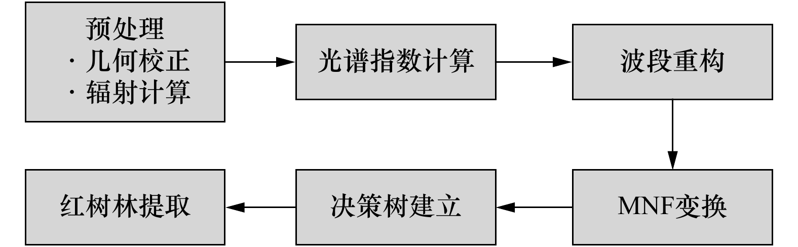
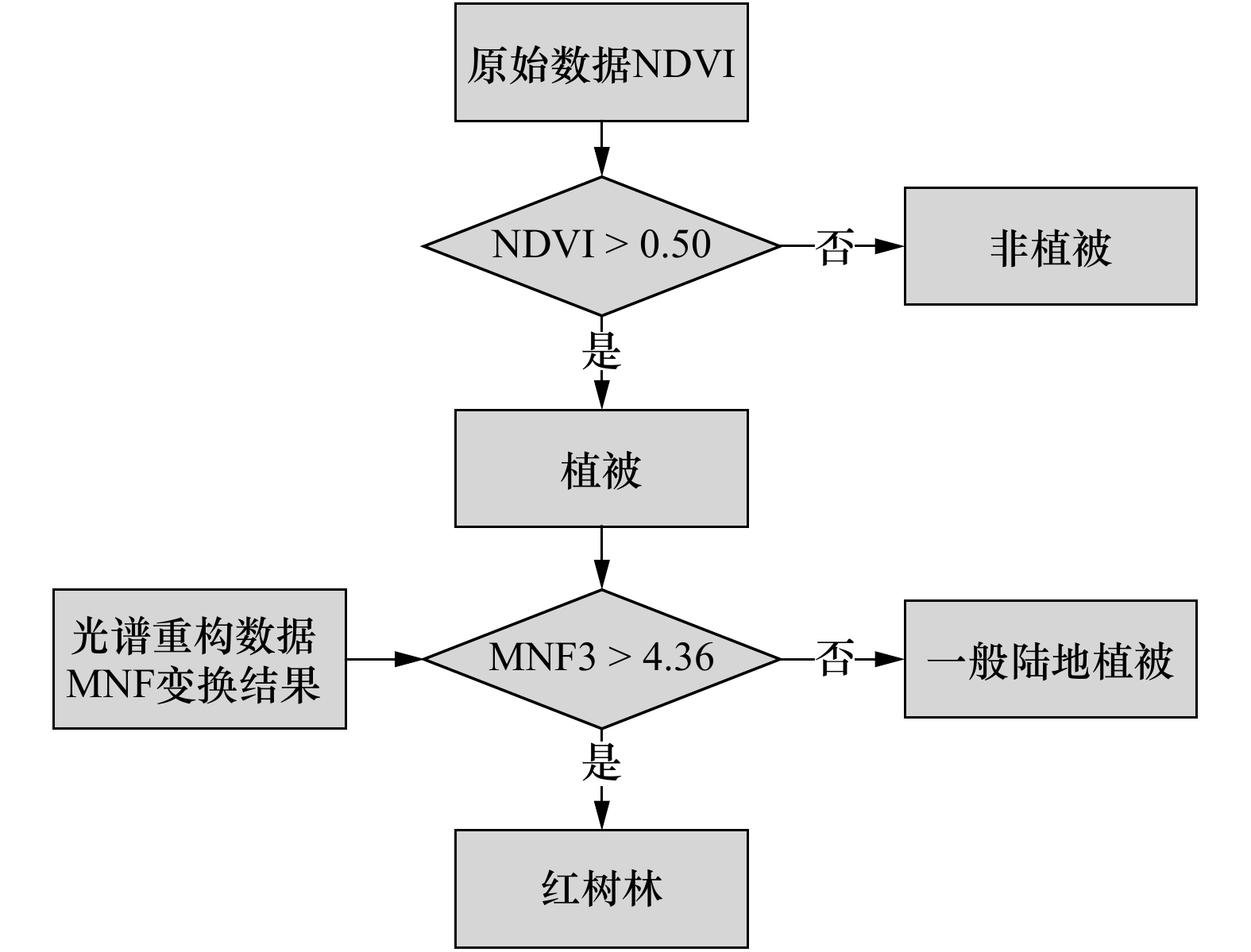
摘要: 本文基于广西山口国家红树林生态自然保护区的HY-1C卫星的海岸带成像仪(Coastal Zone Imager,CZI)影像,分析了红树林与一般陆地植被的光谱特征及其光谱指数的相关性,采用归一化差值植被指数(Normalized Difference Vegetation Index,NDVI)、归一化差异水分指数(Normalized Difference Water Index,NDWI)、大气阻抗植被指数(Atmospheric Impedance Vegetation Index,ARVI)及利用CZI波段构建的光谱斜率比(CZI Visible Spectrum Slope Ratio,CVSSR)4个指数替代CZI原始波段形成重构数据,基于重构数据的最小噪声分离变换(Minimum Noise Fraction Rotation,MNF)结果分量,建立决策树并实现了红树林信息的自动提取。研究结果表明:结合本文所选光谱指数重构数据及MNF变换方法,能够有效增强CZI影像上红树林与一般陆地植被的光谱差异,基于MNF变换分量建立的决策树可有效提取红树林信息,经与专家解译结果比对,本文方法面积准确率达90%以上;经随机样本点验证,总体检测精度为88%。Abstract: In this study, we first used the spectral vegetation indices such as normalized difference vegetation index (NDVI), normalized difference water index (NDWI), atmospheric impedance vegetation index (ARPI) and visible spectrum slope ratio of coastal zone imager (CVSSR) to reconstruct the HY-1C coastal zone imager (CZI) image data of the Shankou mangrove national ecosystem nature reserve in Guangxi. And then, the minimum noise fraction rotation (MNF) was used to enhance the spectral difference between mangroves and general terrestrial vegetation on the reconstructed multi-band data set. We established a decision tree based on the MNF components to achieve automatic extracting mangrove information. The results show that the spectral indices reconstruction data and its MNF transformation can effectively enhance the difference between the mangroves and the general terrestrial vegetation on CZI images, the mangrove information can be effectively extracted by our decision tree. Compared with the experts’ interpretation results, the extracted accuracy of area of our method is over 90%. The overall detection accuracy is 88% after verification by random sample points.
-
Key words:
- HY-1C satellite /
- CZI /
- mangrove /
- spectral indices /
- MNF transformation
-
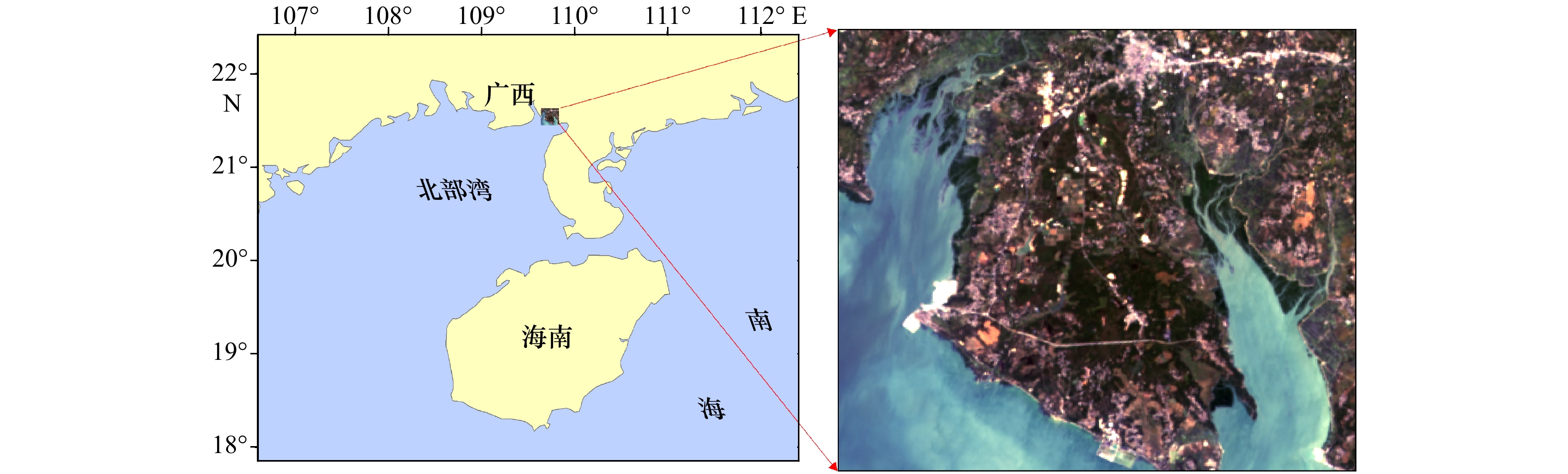
图 1 研究区位置与HY-1C卫星CZI原始影像
Fig. 1 Study area location and the CZI original image of HY-1C satellite
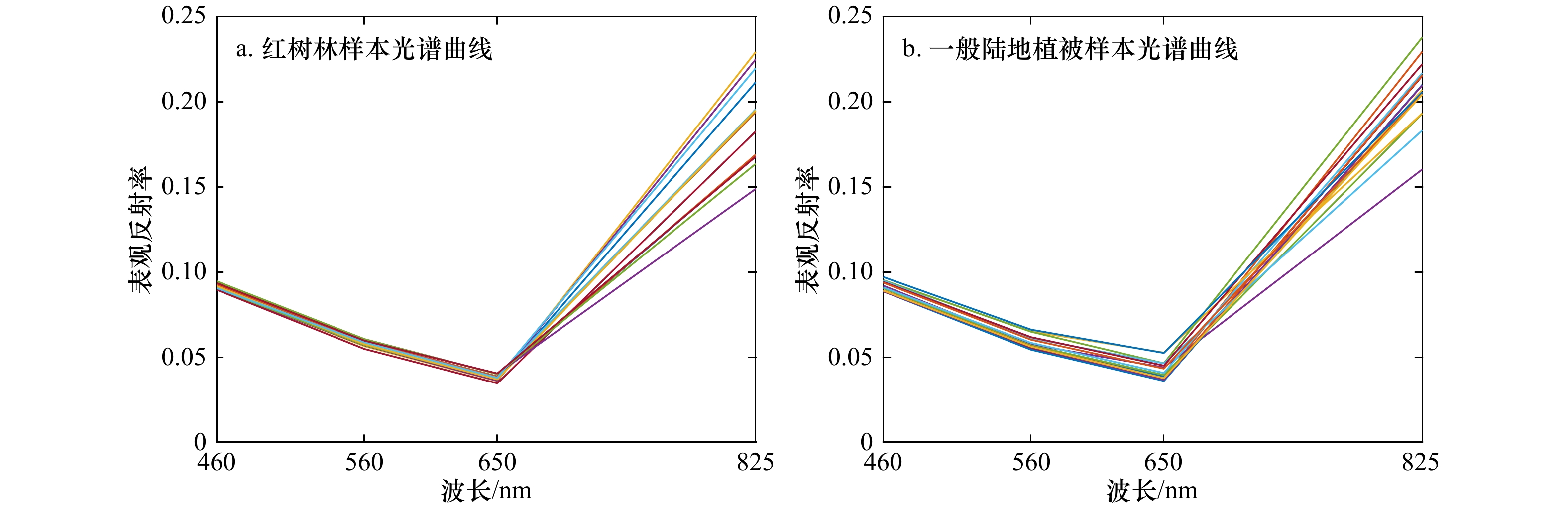
图 3 CZI影像上红树林(a)与一般陆地植被(b)光谱曲线
Fig. 3 Spectral curves of mangrove (a) and general terrestrial vegetation (b) on CZI image
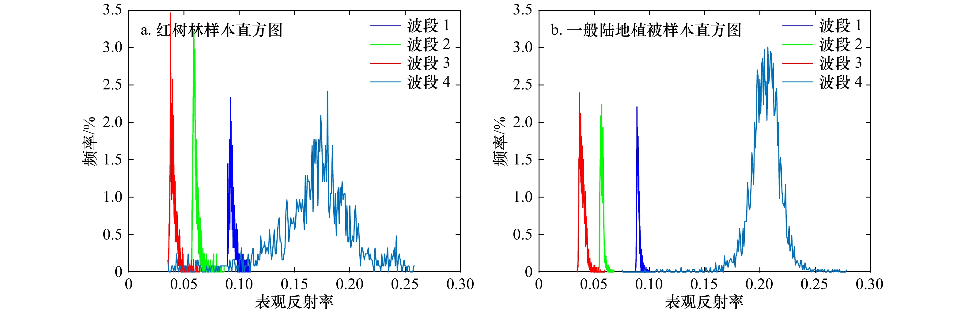
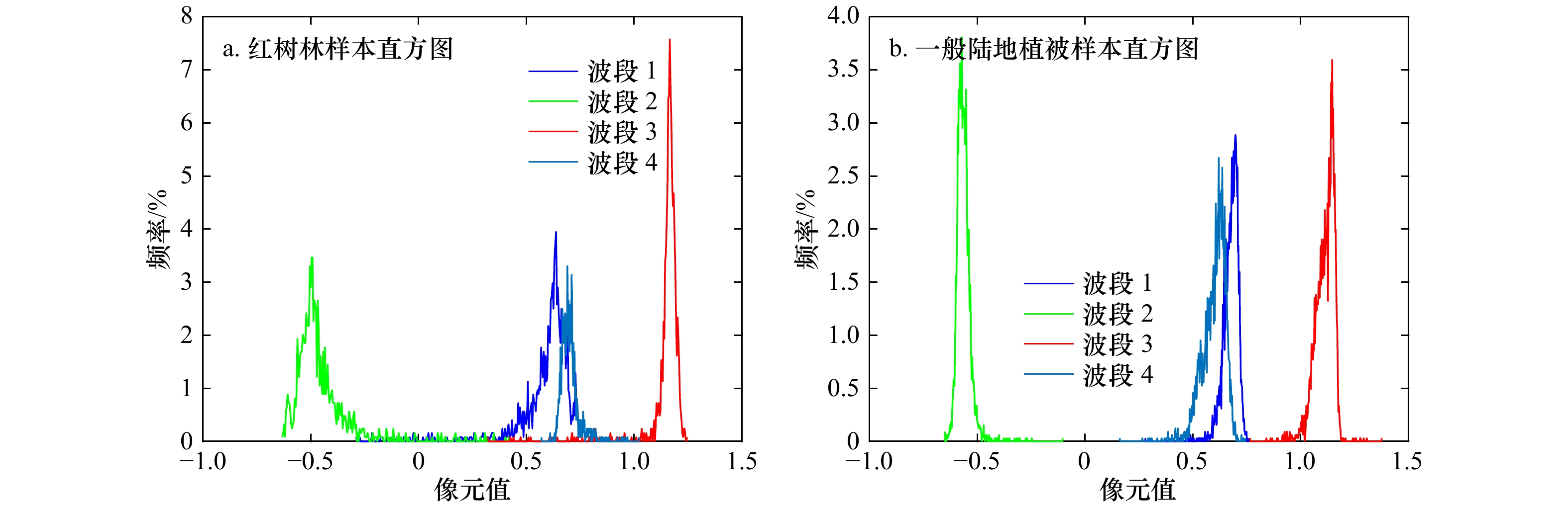
图 4 红树林(a)与一般陆地植被(b)表观反射率分布直方图
Fig. 4 Histograms of apparent reflectance distribution of mangroves (a) and general terrestrial vegetation (b)
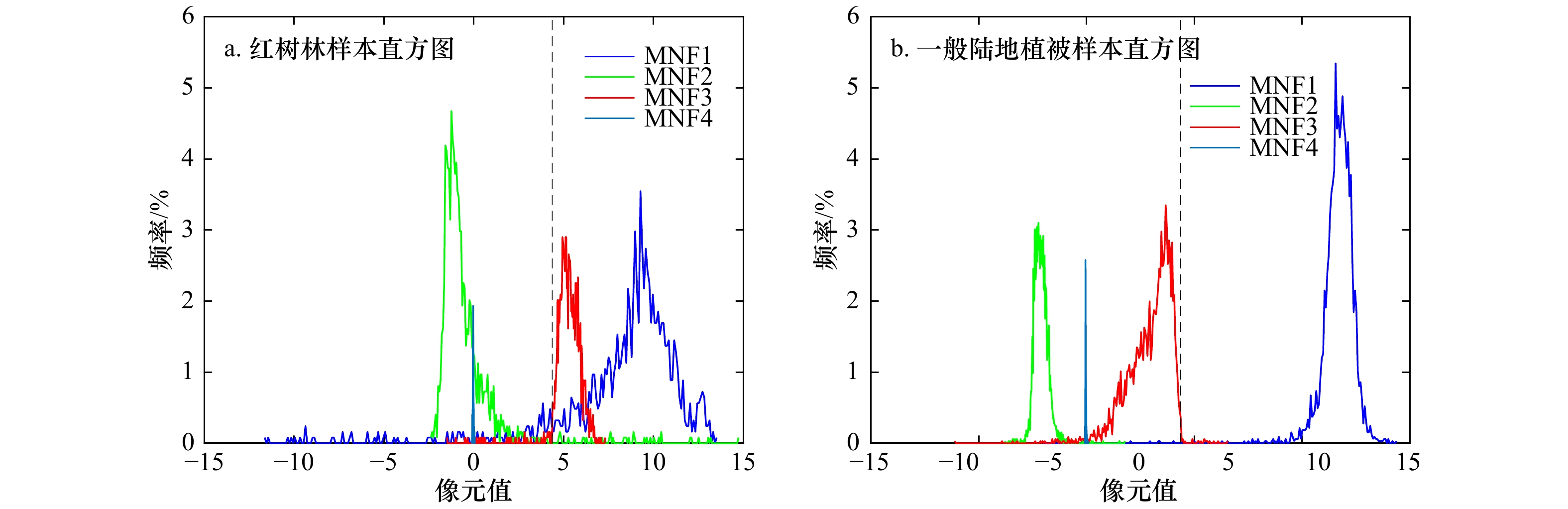
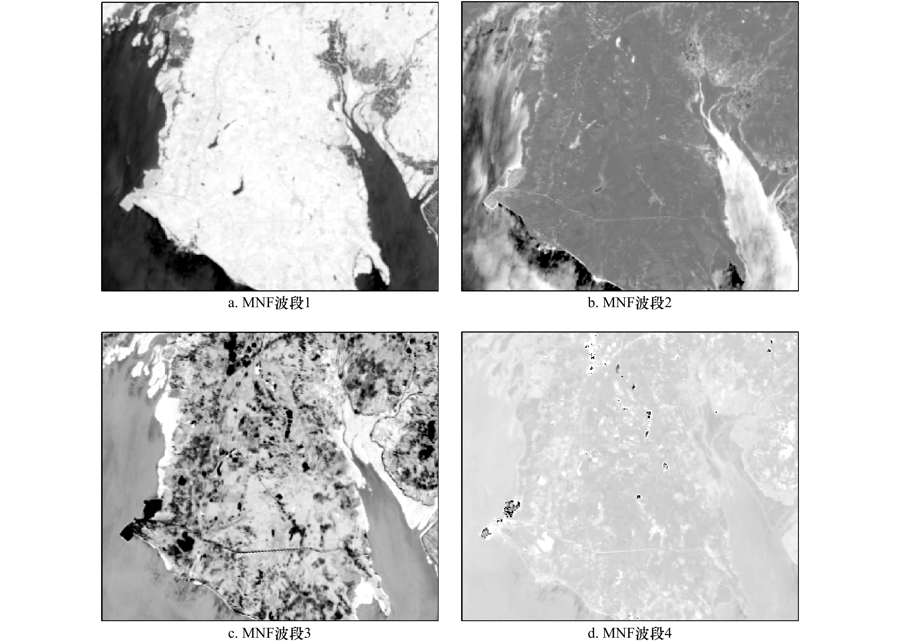
图 7 光谱指数重构数据MNF结果样本直方图
Fig. 7 Histograms of MNF components of the spectral index reconstruction data
表 1 HY-1C卫星CZI传感器主要技术指标
Tab. 1 The main technical indicators of HY-1C satellite CZI sensor
波段 波长范围/nm 空间分辨率/m 1 420~500 50 2 520~600 50 3 610~690 50 4 760~890 50  下载: 导出CSV
表 2 本文使用的植被光谱指数列表
Tab. 2 List of vegetation spectral indices used in this paper
名称 英文全称 简写 公式 选择依据 归一化差值植被指数 Normalized Difference Vegetation Index NDVI $(NIR-R)/(NIR+R) $ 对绿色植被敏感,常用于植被状态研究 比值植被指数 Ratio Vegetation Index RVI $R/NIR $ 对浓密覆盖植被敏感 红色植被指数 Red Vegetation Index RI $(R-G)/(R+G) $ 对土壤颜色影响的植被指数的校正 结构不敏感色素指数 Structure Insensitive Pigment Index SIPI $(NIR-B)/(NIR+R) $ 标识植被冠层胁迫性的增加 归一化差异水分指数 Normalized Difference Water Index NDWI $(G-NIR)/(G+NIR) $ 对土壤湿度敏感 归一化差异绿度指数 Normalized Difference Greenness Index NDGI $(G-R)/(G+R) $ 用于检验不同活力植被形式 修改型土壤调节植被指数 Modified Soil-adjusted Vegetation Index MSAVI $[2NIR + 1 - \sqrt { { {\left( {2NIR + 1} \right)}^2} - 8\left( {NIR - R} \right)} ]/2$ 调整土壤背景对植被指数的影响,并减少裸土的影响 增强型植被指数 Enhanced Vegetation Index EVI $2.5[(NIR-R)/(NIR+6R-7.5B+1)] $ 同时修订土壤背景和大气噪声的影响 大气阻抗植被指数 Atmospheric Impedance Vegetation Index ARVI $[NIR-(2R-B)]/[NIR+(2R-B)] $ 减少大气散射对植被指数的影响 CZI蓝红波段比 CZI Blue-Red Wave Segment Ratio CBRI $(B-R)/(B+R) $ 反映不同地物在CZI波段之间差异性变化 CZI蓝绿波段比 CZI Blue-Green Wave Segment Ratio CBGI $(B-G)/(B+G) $ 反映不同地物在CZI波段之间差异性变化 CZI近红外蓝光波段比 CZI Near Infrared-Blue Wave Segment Ratio CNBI $(NIR-B)/(NIR+B) $ 反映不同地物在CZI波段之间差异性变化 CZI可见光光谱斜率比 CZI Visible Spectrum Slope Ratio CVSSR $\left( {\dfrac{{R - G}}{{650 - 560}}} \right)\bigg/\left( {\dfrac{{G - B}}{{560 - 460}}} \right)$ 反映不同植被在可见光波段的光谱形态差异 注:NIR代表近红外波段,R代表红波段,G代表绿波段,B代表蓝波段。
下载: 导出CSV
表 3 NDVI与其他光谱指数间的相关系数
Tab. 3 Correlation coefficients between NDVI and the other spectral indices
光谱指数 与NDVI之间相关系数 光谱指数 与NDVI之间相关系数 RVI −0.985 MSAVI 0.978 RI 0.413 EVI 0.989 SIPI 0.989 CBRI −0.004 NDWI −0.996 CBGI 0.608 NDGI −0.413 ARVI −0.238 CNBI 0.996 CVSSR −0.063
下载: 导出CSV
-
[1] Aschbacher J, Ofren R, Delsol J P, et al. An integrated comparative approach to mangrove vegetation mapping using advanced remote sensing and GIS technologies: preliminary results[J]. Hydrobiologia, 1995, 295: 285−294. doi: 10.1007/BF00029135 [2] Green E P, Clark C D, Mumby A J, et al. Remote sensing techniques for mangrove mapping[J]. International Journal of Remote Sensing, 1998, 19(5): 935−956. doi: 10.1080/014311698215801 [3] Green E P, Mumby P J, Edwards A J, et al. The assessment of mangrove areas using high resolution multispectral airborne imagery[J]. Journal of Coastal Research, 1998, 14(2): 433−443. [4] Wang Lanfa, Sousa W, Gong P. Integration of object-based and pixel-based classification for mapping mangroves with IKONOS imagery[J]. International Journal of Remote Sensing, 2004, 25(24): 5655−5668. doi: 10.1080/014311602331291215 [5] 肖海燕, 曾辉, 昝启杰, 等. 基于高光谱数据和专家决策法提取红树林群落类型信息[J]. 遥感学报, 2007, 11(4): 531−537. doi: 10.11834/jrs.20070473Xiao Haiyan, Zeng Hui, Zan Qijie, et al. Decision tree model in extraction of mangrove community information using hyperspectral image data[J]. Journal of Remote Sensing, 2007, 11(4): 531−537. doi: 10.11834/jrs.20070473 [6] 张雪红. 基于知识与规则的红树林遥感信息提取[J]. 南京信息工程大学学报, 2011, 3(4): 341−345. doi: 10.3969/j.issn.1674-7070.2011.04.005Zhang Xuehong. Remote sensing information extraction of mangrove based on knowledge and rules[J]. Journal of Nanjing University of Information Science & Technology, 2011, 3(4): 341−345. doi: 10.3969/j.issn.1674-7070.2011.04.005 [7] Heumann B W. Satellite remote sensing of mangrove forests: recent advances and future opportunities[J]. Progress in Physical Geography: Earth and Environment, 2011, 35(1): 87−108. doi: 10.1177/0309133310385371 [8] 张雪红. 基于决策树方法的Landsat8 OLI影像红树林信息自动提取[J]. 国土资源遥感, 2016, 28(2): 182−187. doi: 10.6046/gtzyyg.2016.02.28Zhang Xuehong. Decision tree algorithm of automatically extracting mangrove forests information from Landsat 8 OLI imagery[J]. Remote Sensing for Land & Resources, 2016, 28(2): 182−187. doi: 10.6046/gtzyyg.2016.02.28 [9] Giri C. Observation and monitoring of mangrove forests using remote sensing: opportunities and Challenges[J]. Remote Sensing, 2016, 8(9): 783. doi: 10.3390/rs8090783 [10] Cao Jingjing, Leng Wanchun, Liu Kai, et al. Object-based mangrove species classification using unmanned aerial vehicle hyperspectral images and digital surface models[J]. Remote Sensing, 2018, 10(1): 89. [11] Abdel-Hamid A, Dubovyk O, El-Magd I, et al. Mapping mangroves extents on the red sea coastline in Egypt using polarimetric SAR and high resolution optical remote sensing data[J]. Sustainability, 2018, 10(3): 646. doi: 10.3390/su10030646 [12] Zulfa A W, Norizah K. Remotely sensed imagery data application in mangrove forest: a review[J]. Pertanika Journal of Science & Technology, 2018, 26(3): 899−922. [13] Wang Le, Jia Mingming, Yin Dameng, et al. A review of remote sensing for mangrove forests: 1956-2018[J]. Remote Sensing of Environment, 2019, 231: 111223. doi: 10.1016/j.rse.2019.111223 [14] Pham T D, Yokoya N, Bui D T, et al. Remote sensing approaches for monitoring mangrove species, structure, and biomass: opportunities and challenges[J]. Remote Sensing, 2019, 11(3): 230. doi: 10.3390/rs11030230 [15] Markham B L, Barker J L. Thematic Mapper bandpass solar exoatmospheric irradiances[J]. International Journal of Remote Sensing, 1987, 8(3): 517−523. doi: 10.1080/01431168708948658 [16] 田庆久, 闵祥军. 植被指数研究进展[J]. 地球科学进展, 1998, 13(4): 327−333. doi: 10.3321/j.issn:1001-8166.1998.04.002Tian Qingjiu, Min Xiangjun. Advances in study on vegetation indices[J]. Advance in Earth Sciences, 1998, 13(4): 327−333. doi: 10.3321/j.issn:1001-8166.1998.04.002 [17] 郭铌. 植被指数及其研究进展[J]. 干旱气象, 2003, 21(4): 71−75.Guo Ni. Vegetation index and its advances[J]. Arid Meteorology, 2003, 21(4): 71−75. [18] Muhsoni F F, Sambah A B, Mahmudi M, et al. Comparison of different vegetation indices for assessing mangrove density using sentinel-2 imagery[J]. International Journal of Geomate, 2018, 14(45): 42−51. [19] Gupta K, Mukhopadhyay A, Giri S, et al. An index for discrimination of mangroves from non-mangroves using LANDSAT 8 OLI imagery[J]. MethodsX, 2018, 5: 1129−1139. doi: 10.1016/j.mex.2018.09.011 [20] Green A A, Berman M, Switzer P, et al. A transformation for ordering multispectral data in terms of image quality with implications for noise removal[J]. IEEE Transactions on Geoscience and Remote Sensing, 1988, 26(1): 65−74. doi: 10.1109/36.3001 [21] Boardman J W, Kruse F A. Automated spectral analysis: a geological example using AVIRIS data, north Grapevine Mountains, Nevada[C]//Proceedings, ERIM Tenth Thematic Conference on Geologic Remote Sensing. Ann Arbor, MI: Environmental Research Institute of Michigan, 1994: 407−418. [22] Richards J A. Remote Sensing Digital Image Analysis[M]. Berlin: Springer, 2013: 186−189. [23] Canty M J. Image Analysis, Classification and Change Detection in Remote Sensing: with Algorithms for ENVI/IDL[M]. New York: CRC Press, 2014. -


计量
- 文章访问数: 378
- HTML全文浏览量: 144
- PDF下载量: 25
- 被引次数: 0
