

Study on inverting seagrass coverage ratio at Dongjiao Coconut Forest based on UAV aerial survey technology
-
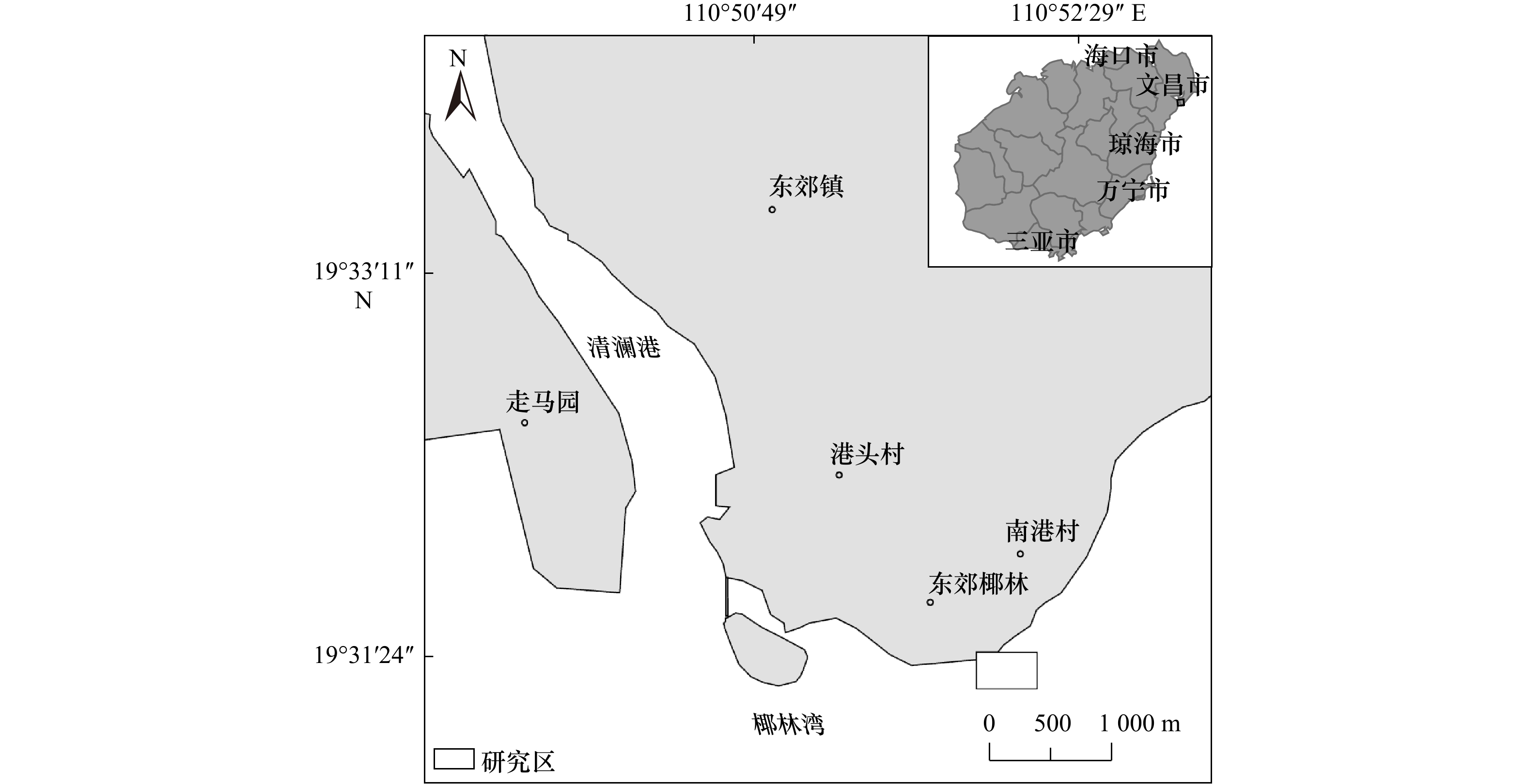
摘要: 海草盖度是反映海草床生态状况的重要指标。本文通过航拍方案设计和飞行条件试验采用无人机航拍获取了东郊椰林海域高分辨率海草影像图,结合ArcGIS软件影像分类工具和3D工具反演了海草分布范围,研究出海草盖度计算的新方法并计算了东郊椰林海底海草的盖度,模拟传统海草盖度调查方法的站点布置,探讨了其结果可比性和代表性问题。研究结果表明,东郊椰林海域海草主要分布于离岸300 m以内的珊瑚礁砰上,呈斑块状、间隔式分布,获取东郊椰林沿岸海草集中分布区面积为23 221 m2,占研究区面积的比例为17.79%;海草覆盖面积约为16 423 m2,海草盖度为12.58%,海草盖度较高,海草床生态状况良好。在研究区的东南区域有马尾藻密集分布,分布面积为755.6 m2,其盖度为0.5%,呈独株圆柱状漂浮生长。通过模拟试验,传统海草盖度调查方法有样框法和样线法,布置站点不同,样框、样线放置有随机性,海草盖度调查结果变动明显,是传统调查方法的结果存在代表性差、可比性差的原因。本研究成果在海草生态监控区调查中具有推广应用价值。
-
关键词:
- 无人机航测 /
- 东郊椰林 /
- 海草盖度 /
- 最大似然法 /
- Iso聚类非监督分类
Abstract: Seagrass coverage ratio is an important indicator reflecting the ecological status of seagrass beds. In this paper, through the design of aerial photography scheme and flight condition test, the high-resolution seagrass image map of the Dongjiao Coconut Forest sea area was obtained by using UAV aerial photography. Combined with the image classification tools of ArcGIS software and 3D tools, a new method for calculating the coverage ratio of seagrass were obtained and the coverage of seagrass was calculated. The station location of simulating survey method of the traditional seagrass coverage ratio was compared and discussed. Seagrasses in the coastal sea bed of the Dongjiao Coconut Forest are distributed on the coral reefs within 300 m from the shore with patches and intervals. Using the new method, the concentrated distribution area of seagrass at sea bed of the Dongjiao Coconut Forest is about 23 221 m2, and average concentration distribution ratio is 17.79%. The distribution area of seagrass in this study area is about 16 423 m2, and the coverage ratio of seagrass is 12.58%. The coverage ratio of seagrass is higher, and the ecological condition of seagrass bed is good. Sargassum is densely distributed in the southeast area of the study area, with a distribution area of 755.6 m2 and a coverage of 0.5%, and grows as a single cylinder floating. By simulating the investigation station location of the sample frame method and sample line method of traditional seagrass coverage survey, seagrass coverage ratio changes with different stations, sample frame, and sample line positions changing randomly, which is the reason for the representativeness and comparability of the traditional survey results. The research results of this project have the promotion and application value in the investigation of seagrass ecological monitoring area. -

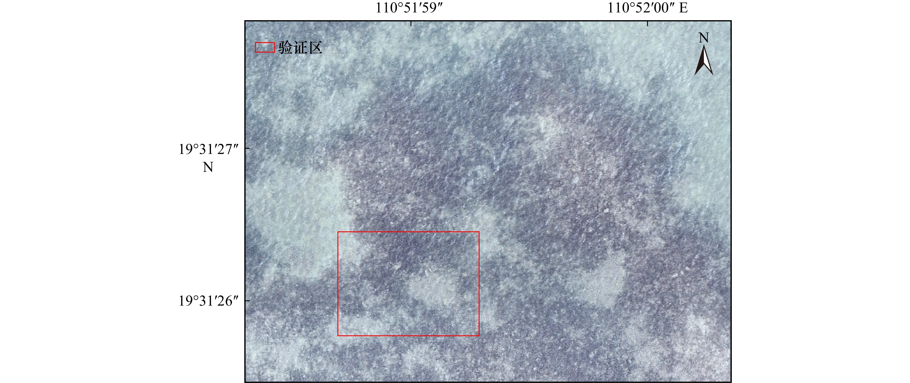
图 3 验证区域的海草分布(20 m, 无人机拍摄)
Fig. 3 Seaweed distribution in validation area (20 m, photo by UAV)

图 5 模拟调查站点布设
a. 样框法; b. 样线法
Fig. 5 Simulatively location of investigation station
a. Enclosing-square method;b. line transect method

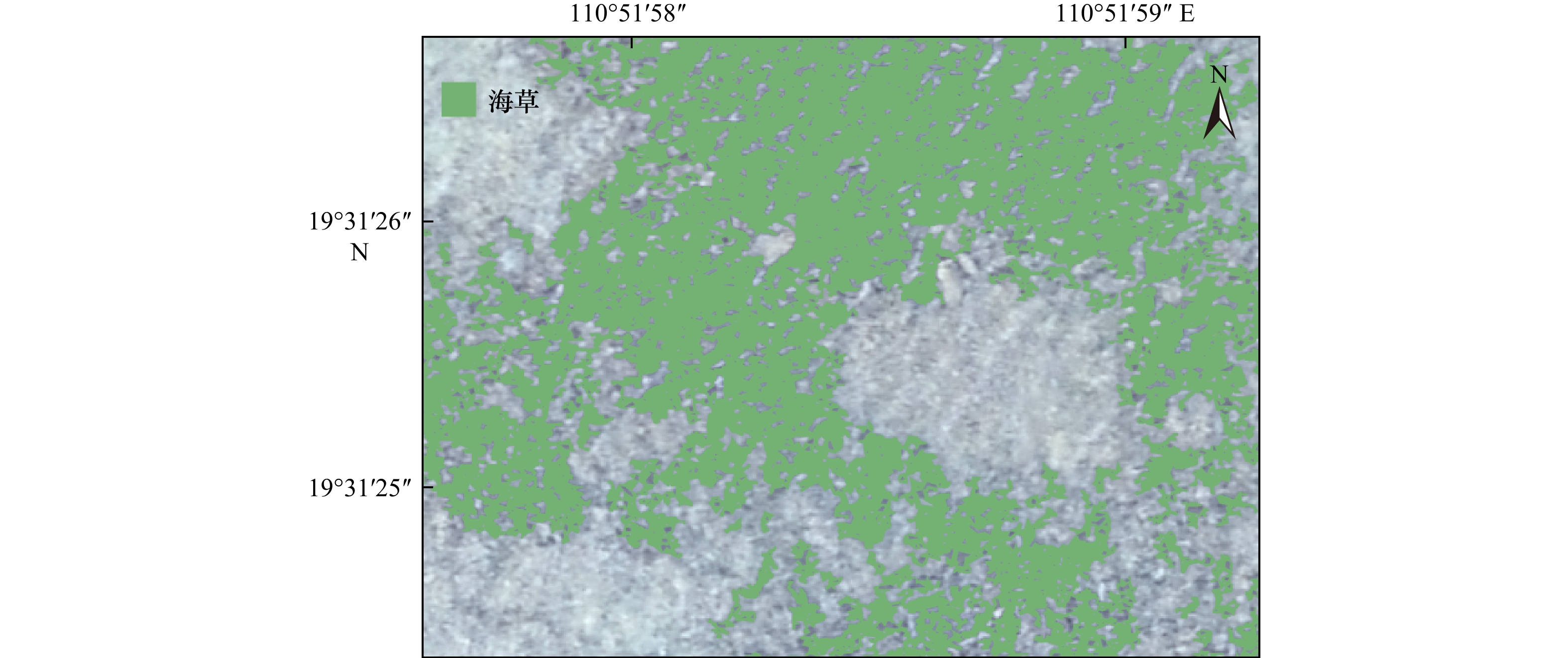
图 7 研究区海草集中分布矢量图
Fig. 7 Vectorgraph of seagrass concentrated distribution at research area
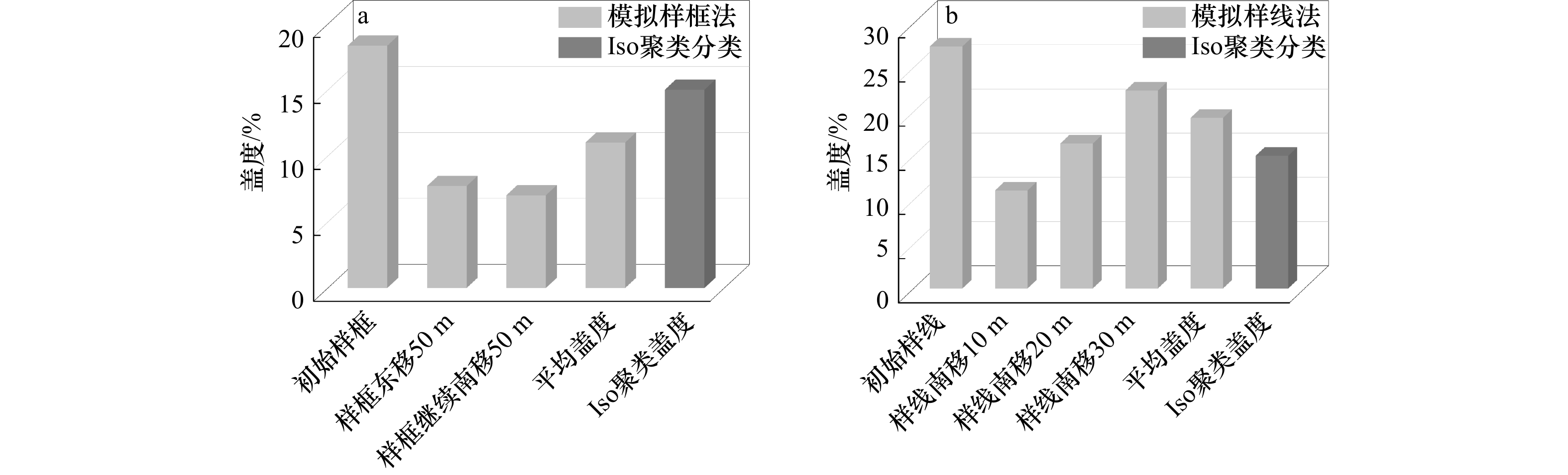
图 9 不同情况下研究区的海草盖度
a. 样框法;b. 样线法
Fig. 9 Seagrass coverage ratio under different conditions at research area
a. Enclosing-square method;b. line transect method
表 1 无人机成像系统参数
Tab. 1 Unmanned aerial vehicle (UAV) imaging system parameters
参数 数值 飞行器 重量 1 391 g 最大起飞海拔高度 6 000 m 飞行时间 约30 min 工作环境因素 0~40℃ 相机 影像传感器 CMOS;有效像素2 000万 照片最大分辨率 5 472 × 3 648(3∶2)  下载: 导出CSV
表 2 研究区海草集中分布特征
Tab. 2 Concentrated distribution feature of seagrass at research area
区块 区块1 区块2 区块3 区块4 区块5 区块6 区块7 区块8 区块9 区块10 区块12 区块13 区块14 区块15 总计 海草集中面积/m2 413 1 076 897 593 152 1 427 2 413 2 176 2 219 912 376 2 813 4 433 3 310 23 221 海域面积/hm2 1 1 1 1 1 1 1 1 1 1 0.166 1 0.889 5 1 1 13.055 6 斑块数/个 292 405 539 232 109 55 64 83 59 38 28 53 23 34 2 014 集中分布比例/% 4.13 10.76 8.97 5.93 1.52 14.27 24.13 21.76 22.19 9.12 22.64 31.62 44.33 33.10 17.79
下载: 导出CSV
表 3 海草盖度计算结果
Tab. 3 Calculation results of seagrass coverage rate
区块 区块1 区块2 区块3 区块4 区块5 区块6 区块7 区块8 区块9 区块10 区块12 区块13 区块14 区块15 总计 海草面积/m2 277 715 816 585 149 1 171 2 056 1 521 1 273 394 283 1 950 2 982 2 251 16 423 海域面积/hm2 1 1 1 1 1 1 1 1 1 1 0.166 1 0.889 5 1 1 13.055 6 海草盖度/% 2.77 7.15 8.16 5.85 1.49 11.71 20.56 15.21 12.73 3.94 17.03 21.92 29.82 22.51 12.58
下载: 导出CSV
表 4 模拟站点样框的海草盖度
Tab. 4 Seagrass coverage ratio at simulative investigation stations enclosing-square
站点 海草面积与盖度 样框L1 样框L2 样框L3 样框L4 样框L5 样框L6 样框L7 样框L8 样框L9 样框L10 样框L11 总计 原站点 面积/m2 7.08 7.01 11.21 2.51 1.17 3.79 − 6.55 11.19 − − 50.51 盖度/% 28.32 28.04 44.84 10.03 4.68 15.16 − 26.2 44.76 − − 18.36 整体向东边平移50 m 面积/m2 − 6.83 3.79 10.18 − − − 0.17 0.30 − − 21.27 盖度/% − 27.32 15.16 40.72 − − − 0.68 1.2 − − 7.73 随后向南边平移50 m 面积/m2 − 2.91 13.61 1.89 0.88 − − − − − − 19.29 盖度/% − 11.64 54.44 7.56 3.52 − − − − − − 7.01 平均盖度/% 11.03 注:“−”表示未发现海草分布。
下载: 导出CSV
表 5 模拟断面拉线调查属性表
Tab. 5 Property sheet of simulated cross-section cable survey
样线 海草长度和盖度 站点D1 站点D2 站点D3 小计 样线L1 样线L2 样线L3 平均/% 样线L1 样线L2 样线L3 平均/% 样线L1 样线L2 样线L3 平均/% 初始样线 海草长度/m 20.1 4.8 0.9 23.7 15.74 14.1 21.1 8.3 14.1 盖度/% 40.2 9.6 1.8 17.2 47.4 31.4 28.2 36.0 42.2 16.6 28.2 29.0 27.4 整体南移10 m 海草长度/m 8.2 0.3 2.7 6.6 4.1 6.5 10.8 4.0 6.5 盖度/% 16.4 0.6 5.4 7.5 13.2 8.2 13.0 11.5 21.4 8.0 13 14.2 11.1 整体向南平移20 m 海草长度/m 4.7 15.0 6.1 28.6 3.8 21.2 12.2 13.4 17.0 盖度/% 9.4 30.0 12.2 17.2 28.6 3.8 21.2 17.9 12.2 13.4 17.0 14.2 16.4 整体向南平移30 m 海草长度/m 2.7 8.3 0.2 13.6 6.8 7.4 24.5 21.5 15.6 盖度/% 5.4 16.6 0.4 7.5 27.2 13.6 14.8 18.5 49.0 43.0 31.2 41.1 22.4 平均/% 12.4 21.0 24.6 19.31
下载: 导出CSV
-
[1] 周媛媛. 海草床资源保护与可持续发展研究[J]. 国土与自然资源研究, 2021(2): 68−71. doi: 10.16202/j.cnki.tnrs.2021.02.021Zhou Yuanyuan. Study on the protection and sustainable development of seagrass bed resources[J]. Territory & Natural Resources Study, 2021(2): 68−71. doi: 10.16202/j.cnki.tnrs.2021.02.021 [2] Fourqurean J W, Duarte C M, Kennedy H, et al. Seagrass ecosystems as a globally significant carbon stock[J]. Nature Geoscience, 2012, 5(7): 505−509. doi: 10.1038/ngeo1477 [3] 韩秋影, 施平. 海草生态学研究进展[J]. 生态学报, 2008, 28(11): 5561−5570. doi: 10.3321/j.issn:1000-0933.2008.11.040Han Qiuying, Shi Ping. Progress in the study of seagrass ecology[J]. Acta Ecologica Sinica, 2008, 28(11): 5561−5570. doi: 10.3321/j.issn:1000-0933.2008.11.040 [4] Duarte C M, Borum J, Short F T, et al. Seagrass ecosystems: their global status and prospects[M]//Polunin N V C. Aquatic Ecosystems. Cambridge: Cambridge University Press, 2008: 281−294. [5] Orth R J, Carruthers T J B, Dennison W C, et al. A global crisis for seagrass ecosystems[J]. Bioscience, 2006, 56(12): 987−996. doi: 10.1641/0006-3568(2006)56[987:AGCFSE]2.0.CO;2 [6] Wahl T, Haigh I D, Woodworth P L, et al. Observed mean sea level changes around the North Sea coastline from 1800 to present[J]. Earth-Science Reviews, 2013, 124: 51−67. doi: 10.1016/j.earscirev.2013.05.003 [7] Waycott M, Duarte C M, Carruthers T J B, et al. Accelerating loss of seagrasses across the globe threatens coastal ecosystems[J]. Proceedings of the National Academy of Sciences of the United States of America, 2009, 106(30): 12377−12381. [8] 黄小平, 黄良民, 李颖虹, 等. 华南沿海主要海草床及其生境威胁[J]. 科学通报, 2006, 51(2): 136−142.Huang Xiaoping, Huang Liangmin, Li Yinghong. Main seagrass beds and threats to their habitats in the coastal sea of South China[J]. Chinese Science Bulletin, 2006, 51(2): 136−142. [9] 陈石泉, 王道儒, 吴钟解, 等. 海南岛东海岸海草床近10 a变化趋势探讨[J]. 海洋环境科学, 2015, 34(1): 48−53. doi: 10.13634/j.cnki.mes.2015.01.009Chen Shiquan, Wang Daoru, Wu Zhongjie, et al. Discussion of the change trend of the seagrass beds in the east coast of Hainan Island in nearly a decade[J]. Marine Environmental Science, 2015, 34(1): 48−53. doi: 10.13634/j.cnki.mes.2015.01.009 [10] 吴钟解, 陈石泉, 蔡泽富, 等. 海南岛海草床分布变化及恢复建议[J]. 海洋环境科学, 2021, 40(4): 542−549. doi: 10.12111/j.mes.20200130Wu Zhongjie, Chen Shiquan, Cai Zefu, et al. Analysis of distribution change and restoration suggestion of the seagrass beds in Hainan Island[J]. Marine Environmental Science, 2021, 40(4): 542−549. doi: 10.12111/j.mes.20200130 [11] 陈春华, 吴钟解, 张光星. 新村港海草床的生态状况及可持续利用探讨[J]. 海洋开发与管理, 2011, 28(11): 74−78. doi: 10.3969/j.issn.1005-9857.2011.11.021Chen Chunhua, Wu Zhongjie, Zhang Guangxing. Discussion on the ecological status and sustainable utilization of seagrass beds in Xincun Port[J]. Ocean Development and Management, 2011, 28(11): 74−78. doi: 10.3969/j.issn.1005-9857.2011.11.021 [12] 王道儒, 吴钟解, 陈春华, 等. 海南岛海草资源分布现状及存在威胁[J]. 海洋环境科学, 2012, 31(1): 34−38. doi: 10.3969/j.issn.1007-6336.2012.01.008Wang Daoru, Wu Zhongjie, Chen Chunhua, et al. Distribution of sea-grass resources and existing threat in Hainan Island[J]. Marine Environmental Science, 2012, 31(1): 34−38. doi: 10.3969/j.issn.1007-6336.2012.01.008 [13] 陈石泉, 林国尧, 蔡泽富, 等. 海南东寨港海草资源分布特征及影响因素[J]. 湿地科学与管理, 2019, 15(4): 53−56. doi: 10.3969/j.issn.1673-3290.2019.04.13Chen Shiquan, Lin Guoyao, Cai Zefu, et al. Patterns and impacting factors of the distribution of the seagrass resources in Dongzhai Harbour of Hainan[J]. Wetland Science & Management, 2019, 15(4): 53−56. doi: 10.3969/j.issn.1673-3290.2019.04.13 [14] 李政, 李文涛, 杨晓龙, 等. 威海荣成桑沟湾海域海草床分布现状及其生态特征[J]. 海洋科学, 2020, 44(10): 52−59.Li Zheng, Li Wentao, Yang Xiaolong, et al. Distribution and ecological characteristics of seagrass beds in Rongcheng Sanggou Bay, Weihai[J]. Marina Sciences, 2020, 44(10): 52−59. [15] 杨中华, 庞海. 我国资源环境监测中遥感技术应用现状及展望[J]. 中外企业家, 2009(12): 164−165.Yang Zhonghua, Pang Hai. Application status and prospect of remote sensing technology in resource and environmental monitoring in China[J]. Chinese & Foreign Entrepreneurs, 2009(12): 164−165. [16] Guerrero M K M R, Vivar J A M, Ramos R V, et al. Assessment of seagrass percent cover and water quality using UAV images and field measurements in Bolinao, Pangasinan[J]. The International Archives of the Photogrammetry, Remote Sensing and Spatial Information Sciences, 2019, XLII-4/W19: 233−240. doi: 10.5194/isprs-archives-XLII-4-W19-233-2019 [17] Nahirnick N K, Hunter P, Costa M, et al. Benefits and challenges of UAS imagery for eelgrass (Zostera marina) mapping in small estuaries of the Canadian west coast[J]. Journal of Coastal Research, 2019, 35(3): 673−683. doi: 10.2112/JCOASTRES-D-18-00079.1 [18] Chand S, Bollard B. Detecting the spatial variability of seagrass meadows and their consequences on associated macrofauna benthic activity using novel drone technology[J]. Remote Sensing, 2022, 14(1): 160. [19] Ventura D, Bonifazi A, Gravina M F, et al. Mapping and classification of ecologically sensitive marine habitats using unmanned aerial vehicle (UAV) imagery and object-based image analysis (OBIA)[J]. Remote Sensing, 2018, 10(9): 1331. doi: 10.3390/rs10091331 [20] Pasqualini V, Pergent-martini C, Pergent G, et al. Use of SPOT 5 for mapping seagrasses: an application to Posidonia oceanica[J]. Remote Sensing of Environment, 2005, 94(1): 39−45. doi: 10.1016/j.rse.2004.09.010 [21] Barillé L, Robin M, Harin N, et al. Increase in seagrass distribution at Bourgneuf Bay (France) detected by spatial remote sensing[J]. Aquatic Botany, 2010, 92(3): 185−194. doi: 10.1016/j.aquabot.2009.11.006 [22] Yang Chaoyu, Yang Dingtian, Cao Wenxi, et al. Analysis of seagrass reflectivity by using a water column correction algorithm[J]. International Journal of Remote Sensing, 2010, 31(17/18): 4595−4608. [23] Hobley B, Arosio R, French G, et al. Semi-supervised segmentation for coastal monitoring seagrass using RPA imagery[J]. Remote Sensing, 2021, 13(9): 1741. doi: 10.3390/rs13091741 [24] Duffy J P, Pratt L, Anderson K, et al. Spatial assessment of intertidal seagrass meadows using optical imaging systems and a lightweight drone[J]. Estuarine Coastal and Shelf Science, 2018, 200: 169−180. doi: 10.1016/j.ecss.2017.11.001 [25] Chayhard S, Manthachitra V, Naulchawee K, et al. Multi-temporal mapping of seagrass distribution by using integrated remote sensing data in Kung Kraben Bay (KKB), Chanthaburi Province, Thailand[J]. International Journal of Agricultural Technology, 2018, 14(2): 161−170. [26] Konar B, Iken K. The use of unmanned aerial vehicle imagery in intertidal monitoring[J]. Deep-Sea Research Part II: Topical Studies in Oceanography, 2018, 147: 79−86. doi: 10.1016/j.dsr2.2017.04.010 [27] Riniatsih I, Ambariyanto A, Yudiati E, et al. Monitoring the seagrass ecosystem using the unmanned aerial vehicle (UAV) in coastal water of Jepara[J]. IOP Conference Series: Earth and Environmental Science, 2021, 674(1): 012075. doi: 10.1088/1755-1315/674/1/012075 [28] Yang Bo, Hawthorne T L, Searson H, et al. High-resolution UAV mapping for investigating eelgrass beds along the west coast of north America[C]//Proceedings of the IGARSS 2020−2020 IEEE International Geoscience and Remote Sensing Symposium. Waikoloa, HI, USA: IEEE, 2020: 6317−6320. [29] 孙家抦. 遥感原理与应用[M]. 武汉: 武汉大学出版社, 2009.Sun Jiabing. Principles and Applications of Remote Sensing[M]. Wuhan: Wuhan University Press, 2009. [30] 任艳中, 王弟, 李轶涛, 等. 无人机遥感在森林资源监测中的应用研究进展[J]. 中国农学通报, 2020, 36(8): 111−118. doi: 10.11924/j.issn.1000-6850.casb19010104Ren Yanzhong, Wang Di, Li Yitao, et al. Applications of unmanned aerial vehicle-based remote sensing in forest resources monitoring: a review[J]. Chinese Agricultural Science Bulletin, 2020, 36(8): 111−118. doi: 10.11924/j.issn.1000-6850.casb19010104 [31] 周游. 无人机遥感在农田信息监测中的应用进展[J]. 农村实用技术, 2020(8): 92−93.Zhou You. Application progress of UAV remote sensing in farmland information monitoring[J]. Rural Practical Technology, 2020(8): 92−93. [32] 张敏霞, 梅丹英, 高伟俊, 等. 无人机遥感技术在城市绿地监测中的应用进展[J]. 中国城市林业, 2019, 17(5): 5−11. doi: 10.12169/zgcsly.2019.05.12.0005Zhang Minxia, Mei Danying, Gao Weijun, et al. Review on the applications of UAV remote sensing technology to urban green space monitoring[J]. Journal of Chinese Urban Forestry, 2019, 17(5): 5−11. doi: 10.12169/zgcsly.2019.05.12.0005 [33] 蔡泽富, 陈石泉, 吴钟解, 等. 海南岛海湾与潟湖中海草的分布差异及影响分析[J]. 海洋湖沼通报, 2017(3): 74−84. doi: 10.13984/j.cnki.cn37-1141.2017.03.011Cai Zefu, Chen Shiquan, Wu Zhongjie, et al. Distribution differences and environmental effects of seagrasses between bays and lagoons of Hainan Island[J]. Transactions of Oceanology and Limnology, 2017(3): 74−84. doi: 10.13984/j.cnki.cn37-1141.2017.03.011 [34] 郑凤英, 邱广龙, 范航清, 等. 中国海草的多样性、分布及保护[J]. 生物多样性, 2013, 21(5): 517−526.Zheng Fengying, Qiu Guanglong, Fan Hangqing, et al. Diversity, distribution and conservation of Chinese seagrass species[J]. Biodiversity Science, 2013, 21(5): 517−526. [35] 陈春华, 蔡绍孟, 刘建波, 等. 无人机航测技术在海草床调查中的试点应用[J]. 应用海洋学学报, 2022, 41(4): 637−643. doi: 10.3969/J.ISSN.2095-4972.2022.04.009Chen Chunhua, Cai Shaomeng, Liu Jianbo, et al. Pilot application of UAV aerial survey technique in seagrass bed investigation[J]. Journal of Applied Oceanography, 2022, 41(4): 637−643. doi: 10.3969/J.ISSN.2095-4972.2022.04.009 -


计量
- 文章访问数: 532
- HTML全文浏览量: 223
- PDF下载量: 60
- 被引次数: 0
