

Estimation of aboveground biomass of mangrove forest using UAV-LiDAR
-
摘要: 红树林作为热带地区碳储量最高的植被类型之一,面积呈现破碎化、减少趋势,地上生物量(AGB)的空间分布及其动态信息对于温室气体通量、碳储量的估算以及政策制定和实施至关重要。但是常用于AGB估算的光学数据或者SAR数据均存在信号饱和现象,且传统估算红树林生物量的算法对数据要求高、估算精度相对较低。针对该问题,本研究使用无人机激光雷达(UAV-LiDAR)数据对比了4种梯度增强决策树算法对于估算入侵红树林物种无瓣海桑AGB的精度,同时探讨了建模过程中的变量重要性。结果表明:(1)XGBR对于评估红树林AGB具有较高的拟合能力,达到R2 = 0.833 8,RMSE = 1.55 Mg/hm2;(2)研究区的无瓣海桑预测AGB的值为73.10~190.00 Mg/hm2,平均值为109.10 Mg/hm2;(3)描述冠层高度特征的激光雷达指标是估计红树林AGB的重要变量。本研究证明了UAV-LiDAR数据与XGBR模型对于估算红树林AGB的可行性,以期为红树林生态系统的蓝碳研究提供数据支撑。Abstract: As one of the vegetation types with the highest carbon storage in tropical regions, the area of mangrove forest shows a trend of fragmentation and reduction. The spatial distribution and dynamic information of mangrove biomass are crucial to the estimation of greenhouse gas flux and carbon storage, as well as policy formulation and implementation. However, both optical data and SAR data commonly used for biomass estimation have signal saturation phenomenon, and traditional estimation algorithms for mangrove biomass estimation have high data requirements and relatively low estimation accuracy. In order to solve this problem, this study compared the accuracy of four gradient enhanced decision tree algorithms for estimating aboveground biomass (AGB) of invasive mangrove species Sonneria apetala used UAV-LiDAR data, and discussed the importance of variables in the modeling process. The results indicate that: (1) XGBR had a high fitting ability for the estimation of mangrove AGB, reaching R² = 0.833 8, RMSE = 1.55 Mg/hm2. (2) The predicted AGB in the study area ranged from 73.10 Mg/hm2 to 190.00 Mg/hm2, with an average of 109.10 Mg/hm2. (3) LiDAR index describing canopy height characteristics is an important variable for estimating mangrove AGB. Conclusion: This study proved the feasibility of UAV-LiDAR data and XGBR model for estimating the AGB of mangrove forests, in order to provide data support for the blue carbon research of mangrove ecosystems.
-
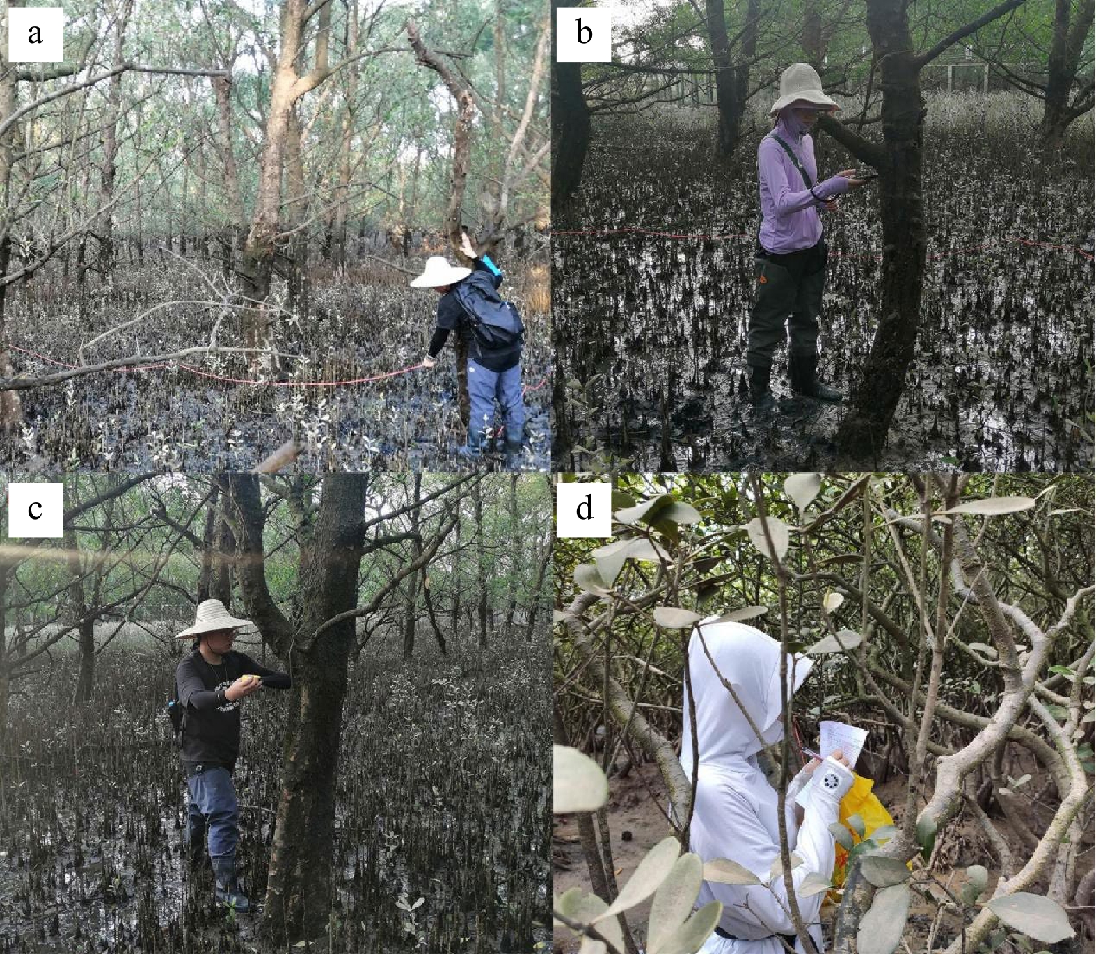
图 2 划定样方点(a)、测定坐标(b)、测定胸径(c)、记录参数值(d)
Fig. 2 Delineate quadrat (a), recording coordinates (b), measure the diameter at breast height (c) and recording data (d)
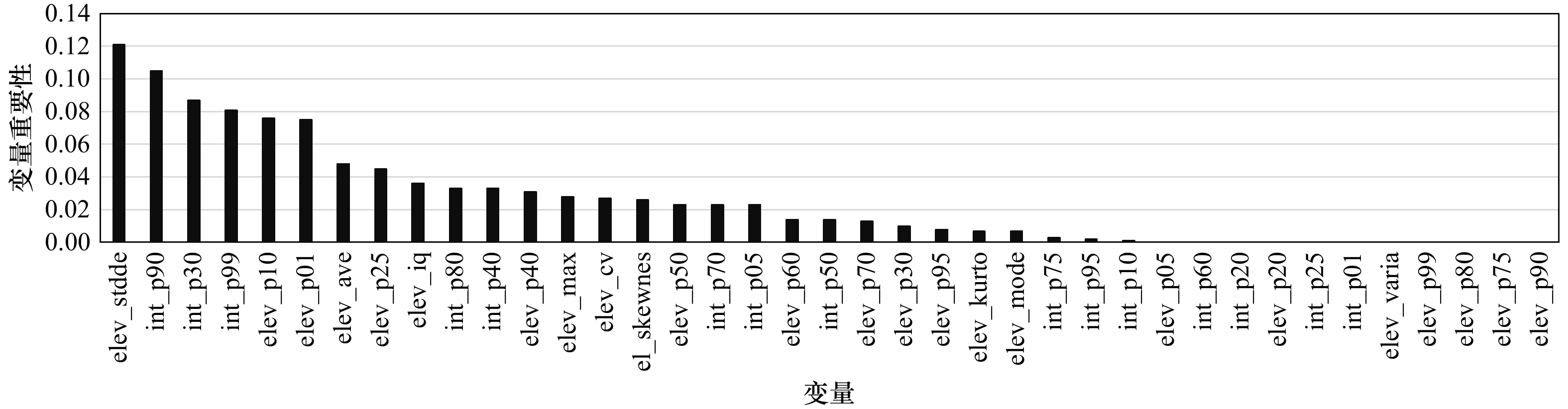
图 4 研究区域红树林的选定变量重要性顺序
Fig. 4 Importance order of selected variables of mangroves in study area
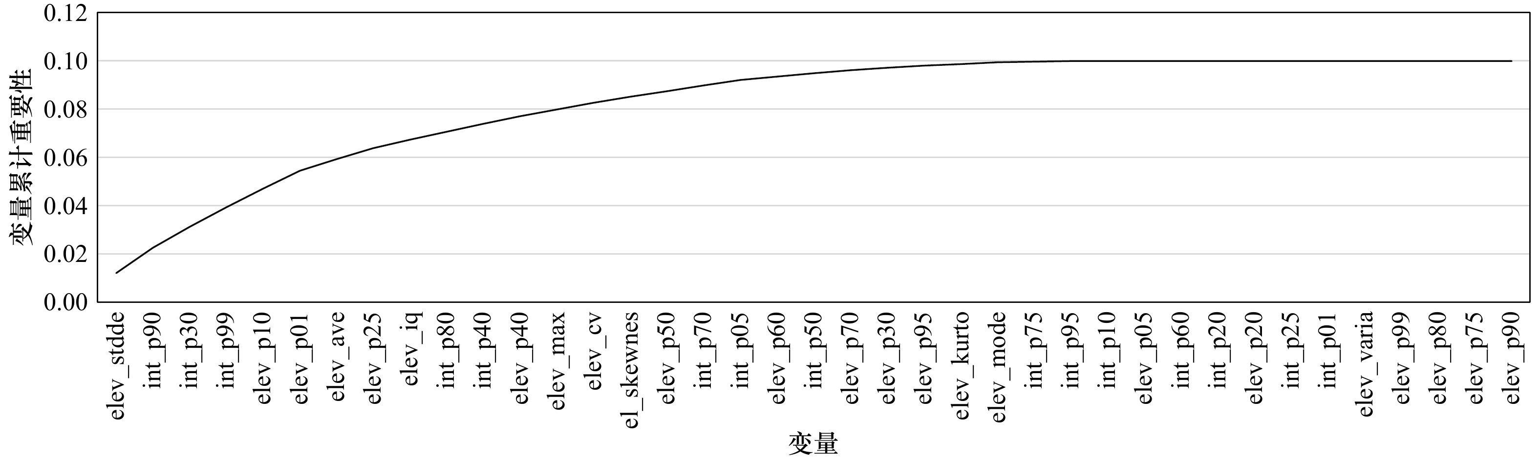
图 5 研究区域红树林的选定变量累计重要性顺序
Fig. 5 The cumulative importance order of selected variables for mangrove forests in the study area
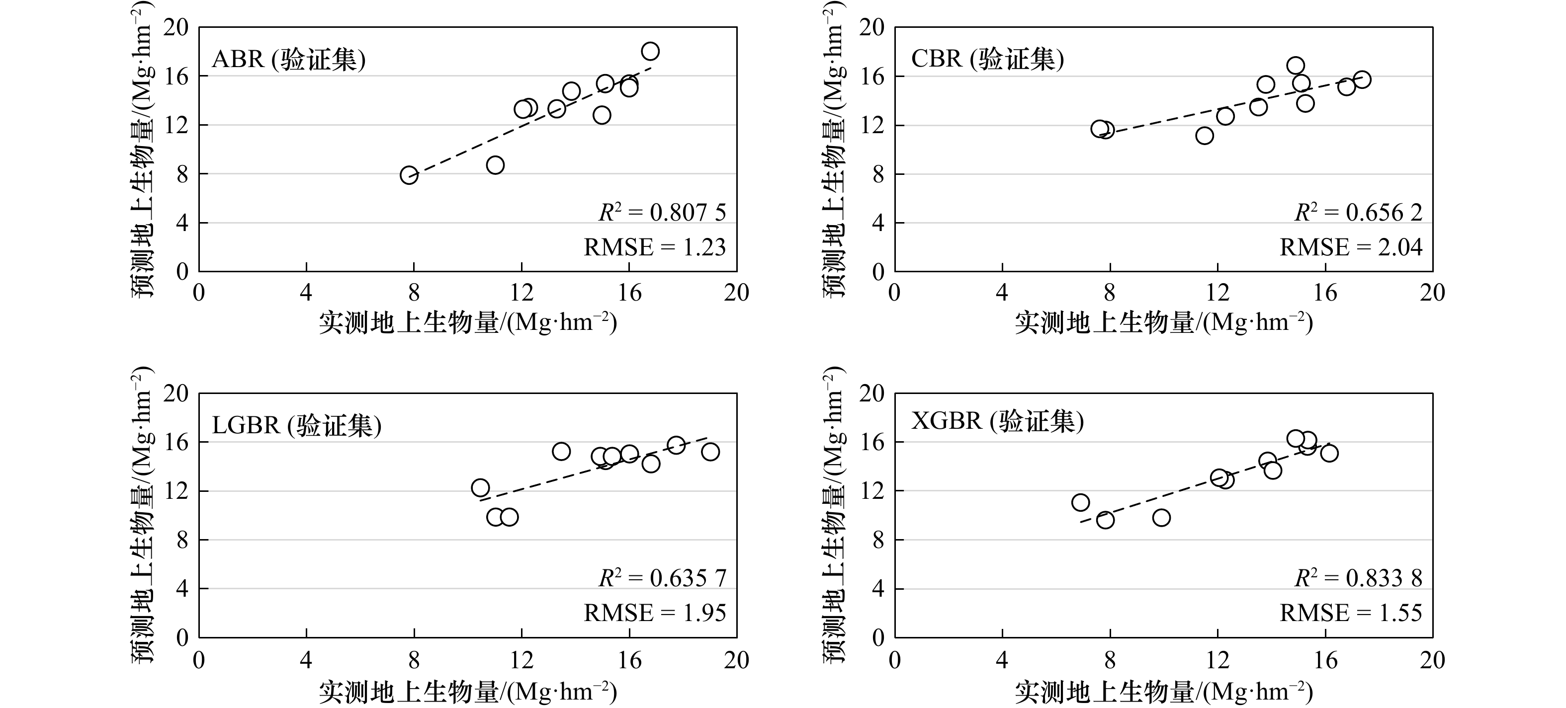
图 6 4种不同ML模型(测试阶段)中实测AGB(X轴)与预测AGB(Y轴)的散点图
Fig. 6 Scatter plots of measured AGB (X axis) and predicted AGB (Y axis) in four different ML models (testing phase)
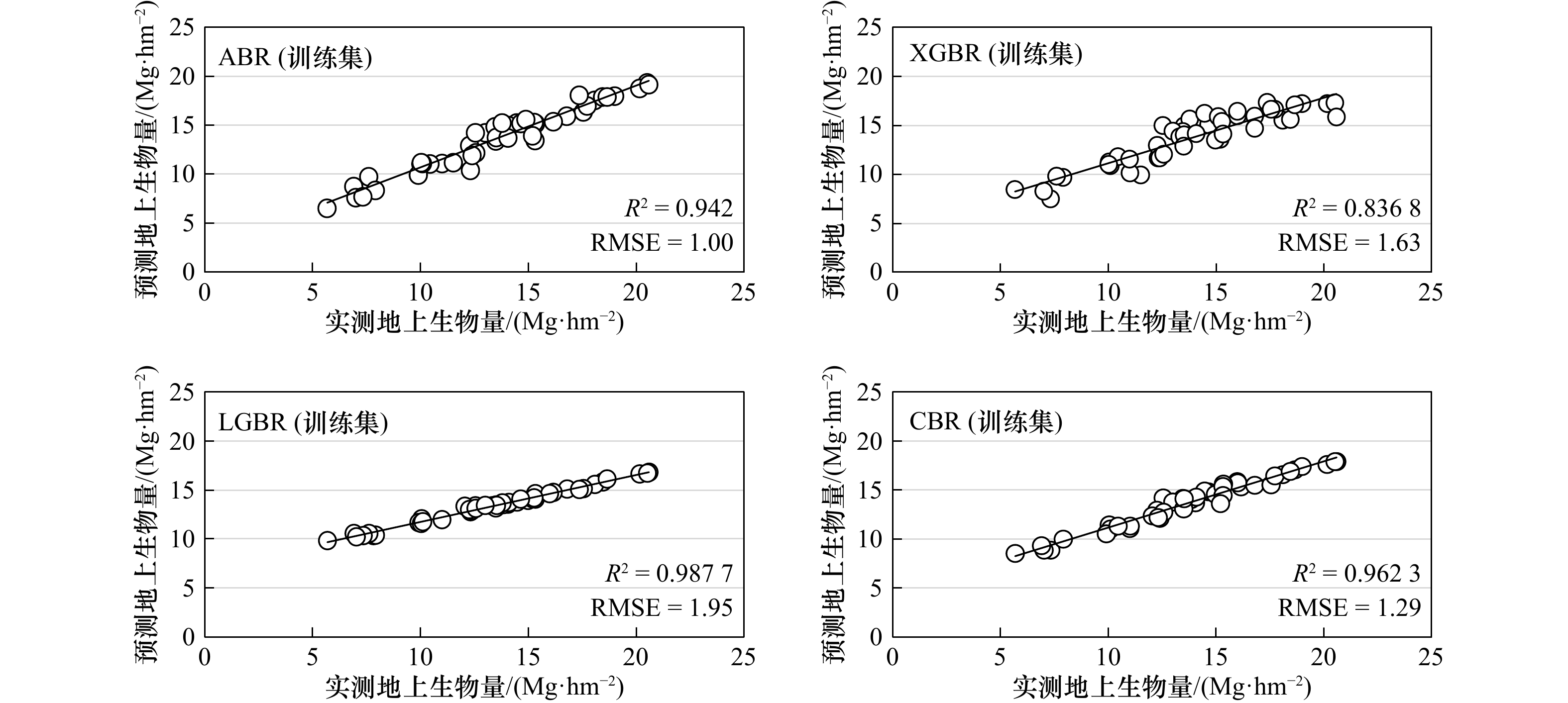
图 7 4种不同ML模型(训练阶段)中实测AGB(X轴)与预测AGB(Y轴)的散点图
Fig. 7 Scatter plots of measured AGB (X axis) and predicted AGB (Y axis) in four different ML models (training phase)

图 8 XGBR反演红树林地上生物量的空间分布
Fig. 8 Spatial distribution of aboveground biomass in mangroves retrieved by XGBR
表 1 林分地上生物量点云特征统计
Tab. 1 Statistics of point cloud characteristics of aboveground biomass in stands
变量 变量意义 计算公式 elev_p01\int_p01, elev_p05\int_p05, elev_p10\int_p10,…,
elev_p99\int_p99所有点云1%、5%、10%、20%、25%、30%、40%、50%、60%、70%、75%、80%、90%、95%、99%分位数处对应的高度\强度值 elev_cv 样方点云高度的变异系数 ${ {\text{cv} } = \dfrac{ \text{stddev} }{ \text{mean} } }$ elev_stddev 样方点云高度的标准差 ${\text{stddev} = \sqrt {\dfrac{1}{n}{ {\displaystyle\sum\limits_{i = 1}^n {({x_i} - \overline x )^2} }} } }$ elev_iq 样方点云百分位数高度的四分位数间距 iq = p75− p25 elev_kurtosis 样方点云高度分布的平坦度 $ {{\text{kurtosis}} = \dfrac{{\begin{array}{*{20}{c}} {\dfrac{1}{{n - 1}}}\;{\displaystyle\sum\limits_{i = 1}^n {\mathop {(\mathop p\nolimits_i - \bar p)}\nolimits^4 } } \end{array}}}{{\mathop \sigma \nolimits^4 }}} $ elev_skewness 样方点云高度分布的对称程度 $ {{\text{skewness}} = \dfrac{{\begin{array}{*{20}{c}} {\dfrac{1}{{n - 1}}}\;{\displaystyle\sum\limits_{i = 1}^n {\mathop {(\mathop p\nolimits_{\text{i}} - \bar p)}\nolimits^3 } } \end{array}}}{{\mathop \sigma \nolimits^3 }}} $ elev_variance 点云高度方差 elev_max 样方点云高度的最大值 elev_ave 样方点云高度的平均值 elev_mode 样方点云高度的众数 注:cv表示变异系数;stddev表示标准差;iq表示四分位间距;kurtosis表示峰度;skewness表示偏态; p25 为25%高度百分位数; p75 为75%高度百分位数;$ \mathop p\nolimits_i $为每一统计单元内第i个点的高度值;$ \bar p $为每一统计单元内所有点的平均高度;$ \sigma $为统计单元内点云高度分布的标准差。  下载: 导出CSV
表 2 实测红树林林木参数
Tab. 2 Measured mangrove tree parameters
参数 最大 最小 平均值 胸径/cm 27.27 17.27 22.48 树高/m 16.74 9.40 13.23 AGB/(Mg·hm−2) 205.95 56.75 133.99
下载: 导出CSV
-
[1] Dasgupta S, Islam M S, Huq M, et al. Quantifying the protective capacity of mangroves from storm surges in coastal Bangladesh[J]. PloS One, 2019, 14(3): e0214079. doi: 10.1371/journal.pone.0214079 [2] 朱耀军, 郭菊兰, 武高洁. 红树林湿地有机碳研究进展[J]. 生态学杂志, 2012, 31(10): 2681−2687. doi: 10.13292/j.1000-4890.2012.0380Zhu Yaojun, Guo Julan, Wu Gaojie. Organic carbon in mangrove wetlands: a review[J]. Chinese Journal of Ecology, 2012, 31(10): 2681−2687. doi: 10.13292/j.1000-4890.2012.0380 [3] 段晓男, 王效科, 逯非, 等. 中国湿地生态系统固碳现状和潜力[J]. 生态学报, 2008, 28(2): 463−469. doi: 10.3321/j.issn:1000-0933.2008.02.002Duan Xiaonan, Wang Xiaoke, Lu Fei, et al. Carbon sequestration and its potential by wetland ecosystems in China[J]. Acta Ecologica Sinica, 2008, 28(2): 463−469. doi: 10.3321/j.issn:1000-0933.2008.02.002 [4] Farzanmanesh R, Khoshelham K, Thomas S. Technological opportunities for measuring and monitoring blue carbon initiatives in mangrove ecosystems[J]. Remote Sensing Applications: Society and Environment, 2021, 24: 100612. doi: 10.1016/j.rsase.2021.100612 [5] Kauffman J B, Heider C, Norfolk J, et al. Carbon stocks of intact mangroves and carbon emissions arising from their conversion in the Dominican Republic[J]. Ecological Applications A Publication of the Ecological Society of America, 2016, 24(3): 518−527. [6] 林天维, 柴清志, 孙子钧, 等. 我国红树林的面积变化及其治理[J]. 海洋开发与管理, 2020, 37(2): 48−52. doi: 10.3969/j.issn.1005-9857.2020.02.008Lin Tianwei, Chai Qingzhi, Sun Zijun, et al. The area change and governance of the Mangrove in China[J]. Ocean Development and Management, 2020, 37(2): 48−52. doi: 10.3969/j.issn.1005-9857.2020.02.008 [7] Nguyen L D, Nguyen C T, Le H S, et al. Mangrove mapping and above-ground biomass change detection using satellite images in coastal areas of Thai Binh Province, Vietnam[J]. Forest and Society, 2019, 3(2): 248−261. doi: 10.24259/fs.v3i2.7326 [8] Pham L T H, Brabyn L. Monitoring mangrove biomass change in Vietnam using SPOT images and an object-based approach combined with machine learning algorithms[J]. ISPRS Journal of Photogrammetry and Remote Sensing, 2017, 128: 86−97. doi: 10.1016/j.isprsjprs.2017.03.013 [9] Baloloy A B, Blanco A C, Candido C G, et al. Estimation of mangrove forest aboveground biomass using multispectral bands, vegetation indices and biophysical variables derived from optical satellite imageries: rapideye, planetscope and sentinel-2[J]. ISPRS Annals of the Photogrammetry, Remote Sensing and Spatial Information Sciences, 2018, IV-3: 29−36. doi: 10.5194/isprs-annals-IV-3-29-2018 [10] Zhu Yuanhui, Liu Kai, Liu Lin, et al. Estimating and mapping mangrove biomass dynamic change using WorldView-2 images and digital surface models[J]. IEEE Journal of Selected Topics in Applied Earth Observations and Remote Sensing, 2020, 13: 2123−2134. doi: 10.1109/JSTARS.2020.2989500 [11] Zhu Yuanhui, Liu Kai, Liu Lin, et al. Retrieval of mangrove aboveground biomass at the individual species level with WorldView-2 images[J]. Remote Sensing, 2015, 7(9): 12192−12214. doi: 10.3390/rs70912192 [12] Suhaili A, Lawen J. Estimation of plant biomass and carbon stock for a juvenile reforested mangrove stand using high resolution imaging spectrometer[C]//2013 5th Workshop on Hyperspectral Image and Signal Processing: Evolution in Remote Sensing (WHISPERS). Gainesville: IEEE, 2013: 1−5. [13] Lucas R, Rebelo L M, Fatoyinbo L, et al. Contribution of L-band SAR to systematic global mangrove monitoring[J]. Marine and Freshwater Research, 2014, 65(7): 589−603. doi: 10.1071/MF13177 [14] Nesha M K, Hussin Y A, van Leeuwen L M, et al. Modeling and mapping aboveground biomass of the restored mangroves using ALOS-2 PALSAR-2 in East Kalimantan, Indonesia[J]. International Journal of Applied Earth Observation and Geoinformation, 2020, 91: 102158. doi: 10.1016/j.jag.2020.102158 [15] Lucas R M, Mitchell A L, Rosenqvist A, et al. The potential of L-band SAR for quantifying mangrove characteristics and change: case studies from the tropics[J]. Aquatic Conservation: Marine and Freshwater Ecosystems, 2007, 17(3): 245−264. doi: 10.1002/aqc.833 [16] 赵天舸, 于瑞宏, 张志磊, 等. 湿地植被地上生物量遥感估算方法研究进展[J]. 生态学杂志, 2016, 35(7): 1936−1946. doi: 10.13292/j.1000-4890.201607.028Zhao Tian’ge, Yu Ruihong, Zhang Zhilei, et al. Estimation of wetland vegetation aboveground biomass based on remote sensing data: a review[J]. Chinese Journal of Ecology, 2016, 35(7): 1936−1946. doi: 10.13292/j.1000-4890.201607.028 [17] Guo Qinghua, Su Yanjun, Hu Tianyu, et al. An integrated UAV-borne lidar system for 3D habitat mapping in three forest ecosystems across China[J]. International Journal of Remote Sensing, 2017, 38(8/10): 2954−2972. [18] 尤号田. 基于机载LiDAR数据森林关键结构参数估测研究[J]. 测绘学报, 2020, 49(12): 1644.You Haotian. Research on forest key structural parameters estimation based on airborne LiDAR data[J]. Acta Geodaetica et Cartographica Sinica, 2020, 49(12): 1644. [19] Salas C, Ene L, Gregoire T G, et al. Modelling tree diameter from airborne laser scanning derived variables: a comparison of spatial statistical models[J]. Remote Sensing of Environment, 2010, 114(6): 1277−1285. doi: 10.1016/j.rse.2010.01.020 [20] Wang Dezhi, Wan Bo, Liu Jing, et al. Estimating aboveground biomass of the mangrove forests on northeast Hainan Island in China using an upscaling method from field plots, UAV-LiDAR data and Sentinel-2 imagery[J]. International Journal of Applied Earth Observation and Geoinformation, 2020, 85: 101986. doi: 10.1016/j.jag.2019.101986 [21] Zolkos S G, Goetz S J, Dubayah R. A meta-analysis of terrestrial aboveground biomass estimation using lidar remote sensing[J]. Remote Sensing of Environment, 2013, 128: 289−298. doi: 10.1016/j.rse.2012.10.017 [22] Feliciano E A, Wdowinski S, Potts M D, et al. Estimating mangrove canopy height and above-ground biomass in the Everglades National Park with airborne LiDAR and TanDEM-X data[J]. Remote Sensing, 2017, 9(7): 702. doi: 10.3390/rs9070702 [23] Wang Dezhi, Wan Bo, Qiu Penghua, et al. Mapping height and aboveground biomass of mangrove forests on Hainan Island using UAV-LiDAR sampling[J]. Remote Sensing, 2019, 11(18): 2156. doi: 10.3390/rs11182156 [24] Qiu Penghua, Wang Dezhi, Zou Xinqing, et al. Finer resolution estimation and mapping of mangrove biomass using UAV LiDAR and worldview-2 data[J]. Forests, 2019, 10(10): 871. doi: 10.3390/f10100871 [25] Salum R B, Robinson S A, Rogers K. A Validated and accurate method for quantifying and extrapolating mangrove above-ground biomass using LiDAR data[J]. Remote Sensing, 2021, 13(14): 2763. doi: 10.3390/rs13142763 [26] Fatoyinbo T, Feliciano E A, Lagomasino D, et al. Estimating mangrove aboveground biomass from airborne LiDAR data: a case study from the Zambezi River delta[J]. Environmental Research Letters, 2018, 13(2): 025012. doi: 10.1088/1748-9326/aa9f03 [27] Francisca R D S P, Kampel M, Soares M L G, et al. Reducing uncertainty in mapping of mangrove aboveground biomass using airborne discrete return lidar data[J]. Remote Sensing, 2018, 10(4): 637. doi: 10.3390/rs10040637 [28] Suyadi, Gao J, Lundquist C J, et al. Aboveground carbon stocks in rapidly expanding mangroves in New Zealand: regional assessment and economic valuation of blue carbon[J]. Estuaries and Coasts, 2020, 43(6): 1456−1469. doi: 10.1007/s12237-020-00736-x [29] Olagoke A, Proisy C, Féret J B, et al. Extended biomass allometric equations for large mangrove trees from terrestrial LiDAR data[J]. Trees, 2016, 30(3): 935−947. doi: 10.1007/s00468-015-1334-9 [30] Salum R B, Souza-Filho P W M, Simard M, et al. Improving mangrove above-ground biomass estimates using LiDAR[J]. Estuarine, Coastal and Shelf Science, 2020, 236: 106585. doi: 10.1016/j.ecss.2020.106585 [31] Pham T D, Yokoya N, Xia Junshi, et al. Comparison of machine learning methods for estimating mangrove above-ground biomass using multiple source remote sensing data in the red river delta biosphere reserve, Vietnam[J]. Remote Sensing, 2020, 12(8): 1334. doi: 10.3390/rs12081334 [32] Pham T D, Le N N, Ha N T, et al. Estimating mangrove above-ground biomass using extreme gradient boosting decision trees algorithm with fused sentinel-2 and ALOS-2 PALSAR-2 data in can Gio biosphere reserve, Vietnam[J]. Remote Sensing, 2020, 12(5): 777. doi: 10.3390/rs12050777 [33] He Hongliang, Zhang Wenyu, Zhang Shuai. A novel ensemble method for credit scoring: adaption of different imbalance ratios[J]. Expert Systems with Applications, 2018, 98: 105−117. doi: 10.1016/j.eswa.2018.01.012 [34] James G, Witten D, Hastie T, et al. An Introduction to Statistical Learning: with Applications in R[M]. New York: Springer, 2013. [35] Li Yingchang, Li Mingyang, Li Chao, et al. Forest aboveground biomass estimation using Landsat 8 and Sentinel-1A data with machine learning algorithms[J]. Scientific Reports, 2020, 10(1): 9952. doi: 10.1038/s41598-020-67024-3 [36] Li Chunhua, Zhou Lizhi, Xu Wenbin. Estimating aboveground biomass using Sentinel-2 MSI data and ensemble algorithms for grassland in the Shengjin Lake Wetland, China[J]. Remote Sensing, 2021, 13(8): 1595. [37] 胡懿凯, 徐耀文, 薛春泉, 等. 广东省无瓣海桑和林地土壤碳储量研究[J]. 华南农业大学学报, 2019, 40(6): 95−103.Hu Yikai, Xu Yaowen, Xue Chunquan, et al. Studies on carbon storages of Sonneratia apetala forest vegetation and soil in Guangdong Province[J]. Journal of South China Agricultural University, 2019, 40(6): 95−103. [38] Tian Yichao, Zhang Qiang, Huang Hu, et al. Aboveground biomass of typical invasive mangroves and its distribution patterns using UAV-LiDAR data in a subtropical estuary: Maoling River Estuary, Guangxi, China[J]. Ecological Indicators, 2022, 136: 108694. doi: 10.1016/j.ecolind.2022.108694 [39] 王照利, 王浩伟, 杨佳乐, 等. 基于归一化植被点云的林分平均高及蓄积量反演[J]. 林业资源管理, 2021(6): 37−42. doi: 10.13466/j.cnki.lyzygl.2021.06.007Wang Zhaoli, Wang Haowei, Yang Jiale, et al. The inversion of average stand height and stock volume based on normalized vegetation point cloud[J]. Forest Resources Management, 2021(6): 37−42. doi: 10.13466/j.cnki.lyzygl.2021.06.007 [40] Ali I, Greifeneder F, Stamenkovic J, et al. Review of machine learning approaches for biomass and soil moisture retrievals from remote sensing data[J]. Remote Sensing, 2015, 7(12): 16398−16421. doi: 10.3390/rs71215841 [41] Chen Lin, Ren Chunying, Zhang Bai, et al. Estimation of forest above-ground biomass by geographically weighted regression and machine learning with sentinel imagery[J]. Forests, 2018, 9(10): 582. doi: 10.3390/f9100582 [42] Anderson K E, Glenn N F, Spaete L P, et al. Estimating vegetation biomass and cover across large plots in shrub and grass dominated drylands using terrestrial lidar and machine learning[J]. Ecological Indicators, 2018, 84: 793−802. doi: 10.1016/j.ecolind.2017.09.034 [43] Luo Mi, Wang Yifu, Xie Yunhong, et al. Combination of feature selection and catboost for prediction: the first application to the estimation of aboveground biomass[J]. Forests, 2021, 12(2): 216. doi: 10.3390/f12020216 [44] 谢勇, 项薇, 季孟忠, 等. 基于Xgboost和LightGBM算法预测住房月租金的应用分析[J]. 计算机应用与软件, 2019, 36(9): 151−155, 191.Xie Yong, Xiang Wei, Ji Mengzhong, et al. An application and analysis of forecast housing rental based on Xgboost and LightGBM algorithms[J]. Computer Applications and Software, 2019, 36(9): 151−155, 191. [45] Tian Yichao, Huang Hu, Zhou Guoqing, et al. Aboveground mangrove biomass estimation in Beibu Gulf using machine learning and UAV remote sensing[J]. Science of the Total Environment, 2021, 781: 146816. doi: 10.1016/j.scitotenv.2021.146816 [46] Huang Zhoumei, Tian Yichao, Zhang Qiang, et al. Estimating mangrove above-ground biomass at Maowei sea, Beibu Gulf of China using machine learning algorithm with sentinel-1 and sentinel-2 data[J] Geocarto International, 2022, 37(27): 15778−15805. [47] Pandey P C, Anand A, Srivastava P K. Spatial distribution of mangrove forest species and biomass assessment using field inventory and earth observation hyperspectral data[J]. Biodiversity and Conservation, 2019, 28(8): 2143−2162. [48] Cohen R. Estimating the above-ground biomass of mangrove forests in Kenya[D]. Edinburgh: The University of Edinburgh, 2014. [49] Fatoyinbo T E, Simard M. Height and biomass of mangroves in Africa from ICESat/GLAS and SRTM[J]. International Journal of Remote Sensing, 2013, 34(2): 668−681. doi: 10.1080/01431161.2012.712224 [50] 魏雪梅. 多源数据支持下的森林地上生物量估算方法[J]. 武汉大学学报·信息科学版, 2019, 44(9): 1385−1390. doi: 10.13203/j.whugis20190149Wei Xuemei. Estimation of Forest aboveground biomass based on multi-source data[J]. Geomatics and Information Science of Wuhan University, 2019, 44(9): 1385−1390. doi: 10.13203/j.whugis20190149 [51] 段祝庚, 赵旦, 曾源, 等. 基于遥感的区域尺度森林地上生物量估算研究[J]. 武汉大学学报·信息科学版, 2015, 40(10): 1400−1408. doi: 10.13203/j.whugis20140709Duan Zhugeng, Zhao Dan, Zeng Yuan, et al. Estimation of the forest aboveground biomass at regional scale based on remote sensing[J]. Geomatics and Information Science of Wuhan University, 2015, 40(10): 1400−1408. doi: 10.13203/j.whugis20140709 [52] Ghosh S M, Behera M D, Paramanik S. Canopy height estimation using sentinel series images through machine learning models in a mangrove forest[J]. Remote Sensing, 2020, 12(9): 1519. doi: 10.3390/rs12091519 [53] Dang A T N, Nandy S, Srinet R, et al. Forest aboveground biomass estimation using machine learning regression algorithm in Yok Don National Park, Vietnam[J]. Ecological Informatics, 2019, 50: 24−32. doi: 10.1016/j.ecoinf.2018.12.010 [54] Noi P T, Kappas M. Comparison of random forest, k-nearest neighbor, and support vector machine classifiers for land cover classification using Sentinel-2 imagery[J]. Sensors, 2017, 18(1): 18. [55] López-Serrano P M, López-Sánchez C A, Álvarez-González J G, et al. A comparison of machine learning techniques applied to landsat-5 TM spectral data for biomass estimation[J]. Canadian Journal of Remote Sensing, 2016, 42(6): 690−705. doi: 10.1080/07038992.2016.1217485 [56] Huang Guomin, Wu Lifeng, Ma Xin, et al. Evaluation of CatBoost method for prediction of reference evapotranspiration in humid regions[J]. Journal of Hydrology, 2019, 574: 1029−1041. doi: 10.1016/j.jhydrol.2019.04.085 [57] Gumus M, Kiran M S. Crude oil price forecasting using XGBoost[C]//2017 International Conference on Computer Science and Engineering (UBMK). Antalya: IEEE, 2017: 1100−1103. [58] 彭聪姣, 钱家炜, 郭旭东, 等. 深圳福田红树林植被碳储量和净初级生产力[J]. 应用生态学报, 2016, 27(7): 2059−2065. doi: 10.13287/j.1001-9332.201607.029Peng Congjiao, Qian Jiawei, Guo Xudong, et al. Vegetation carbon stocks and net primary productivity of the mangrove forests in Shenzhen, China[J]. Chinese the Journal of Applied Ecology, 2016, 27(7): 2059−2065. doi: 10.13287/j.1001-9332.201607.029 [59] Wang Gang, Singh M, Wang Jiaqiu, et al. Effects of marine pollution, climate, and tidal range on biomass and sediment organic carbon in Chinese mangrove forests[J]. CATENA, 2021, 202: 105270. doi: 10.1016/j.catena.2021.105270 [60] Breithaupt J L, Smoak J M, Smith III T J, et al. Organic carbon burial rates in mangrove sediments: strengthening the global budget[J]. Global Biogeochemical Cycles, 2012, 26(3): GB3011. [61] Alongi D M. Carbon cycling and storage in mangrove forests[J]. Annual Review of Marine Science, 2014, 6: 195−219. doi: 10.1146/annurev-marine-010213-135020 [62] Binh C T, Phillips M J, Demaine H. Integrated shrimp-mangrove farming systems in the Mekong delta of Vietnam[J]. Aquaculture Research, 1997, 28(8): 599−610. doi: 10.1111/j.1365-2109.1997.tb01080.x -


计量
- 文章访问数: 802
- HTML全文浏览量: 265
- PDF下载量: 114
- 被引次数: 0
