

Analysis of spatial-temporal distribution evolution and age of existing mangrove forests in Guangdong-Hong Kong-Macao Greater Bay Area using remotely sensed data
-
摘要: 红树林作为热带、亚热带以红树植物为主体的海岸带生态系统,是重要的海岸湿地类型之一。本文使用多源、多时相遥感数据,形成了1969−2020年粤港澳大湾区岸线、围填海、养殖区、红树林分布数据图集,并利用联合红树林识别指数(CMRI)对大湾区现存红树林进行时序分析得到红树林林龄数据集。结果表明,通过多源遥感数据解译得到现存红树林数据集,结合CMRI时序数据可以建立现存红树林变迁历史,进而有效估算红树林林龄。粤港澳大湾区红树林的时空分布发生了明显变迁,现存红树林面积约为3 316 hm2,大湾区内部各地区存量林龄差异较大,整体林龄均值为20 a。近50年间,岸线整体向海移动,岸线变迁、围填海和养殖区变化显著影响红树林面积、空间分布及林龄大小,人工种植是近20年红树林恢复的主因。Abstract: Mangroves forests, as a coastal zone ecosystem dominated by mangrove plants in the tropics and subtropics, are one of the important coastal wetland types. In this paper, multi-source and multi-phase satellite data were used to form a data atlas of shoreline, reclamation, aquaculture area, mangrove distribution in the Guangdong-Hong Kong-Macao Greater Bay Area from 1969 to 2020, and the time series analysis of the evolution of mangroves in the Greater Bay Area was obtained by using the combine mangrove recognition index (CMRI). The results show that the existing mangrove forests data set can be obtained by interpreting the multi-source remote sensing data, and the CMRI time series data can establish the history of the existing mangrove forest change, and then effectively estimate the mangrove forest age. The temporal and spatial distribution of mangroves in the Guangdong-Hong Kong-Macao Greater Bay Area has undergone obvious changes, with the existing mangroves being about 3 316 hm2, and the existing forest age in various regions in the Greater Bay Area is quite different, and the overall average forest age is 20 a. In the past 50 years, the shoreline as a whole has moved towards the sea, and the changes in shoreline, reclamation, and breeding areas have significantly affected the area, spatial distribution, and age of mangroves. Artificial cultivation has been the main reason for the restoration of mangroves in the past 20 years.
-
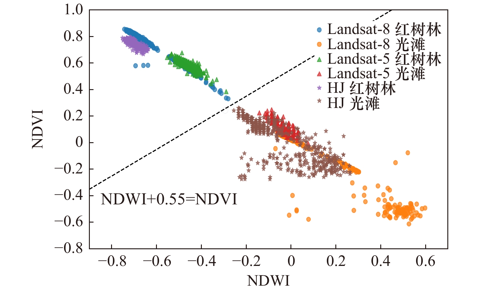
图 3 不同传感器对红树林及光滩的可分性
光滩包含淹水及未淹水两种状态
Fig. 3 Separability of mangrove and tidal flats by different sensors
The tidal flats include two states: flooded and unflooded

图 4 3类不同林龄红树林的CMRI时序数据
Fig. 4 The CMRI time series data of three kinds of mangrove forests with different ages
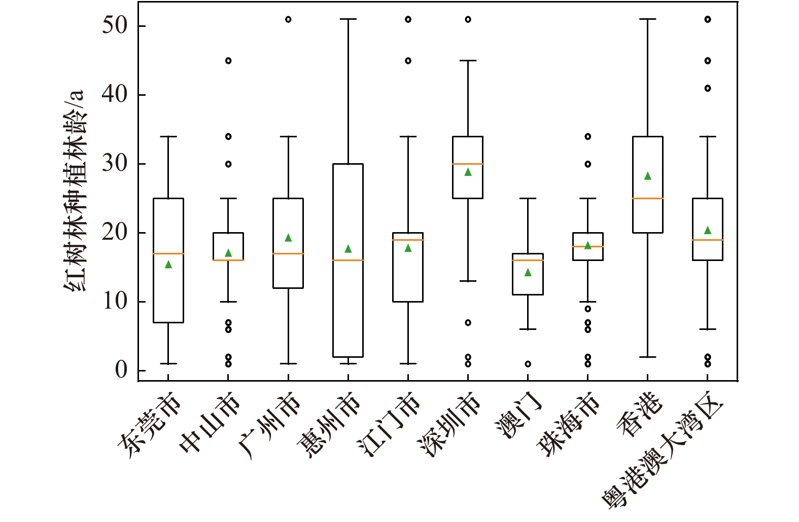
图 6 现存红树林种植林龄
离群值表示该地区存在过高/低林龄红树林
Fig. 6 Existing mangrove forest planting age
Outliers indicate the presence of mangroves of too high/low stand age in the area
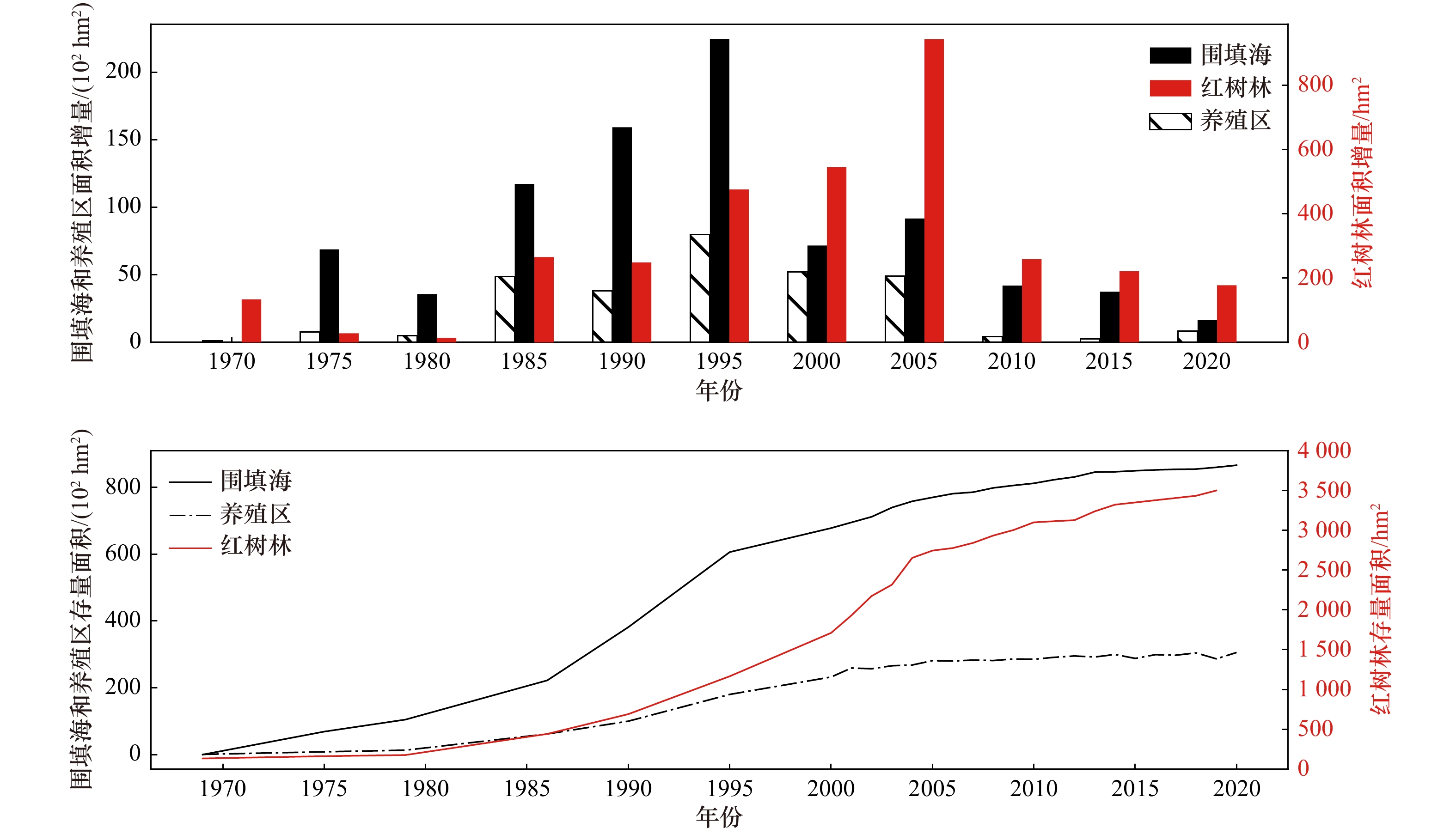
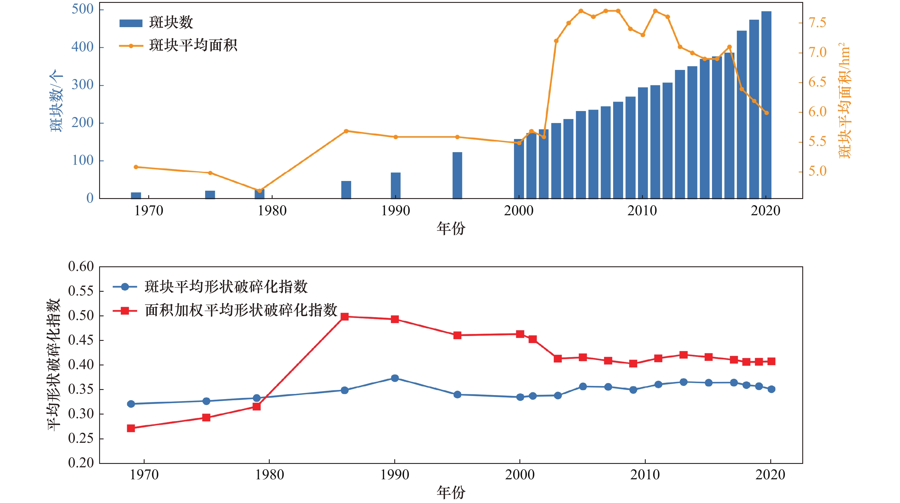
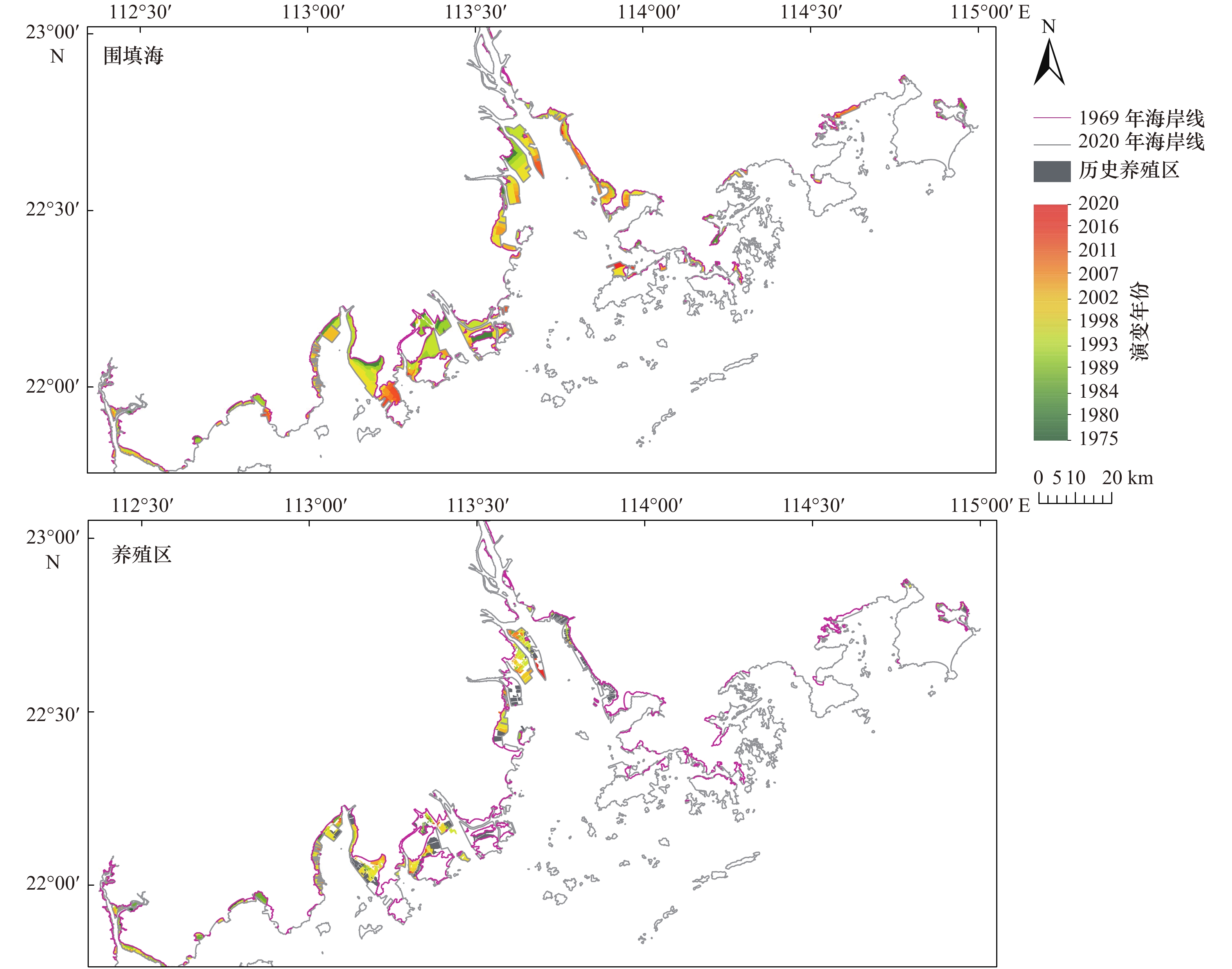
图 10 围填海、养殖区及现存红树林面积每5年增量变化及存量面积统计
Fig. 10 Changes in reclamation, aquaculture areas, and existing mangrove areas every 5 years and stock area statistics

图 11 CMRI提取的林龄(a)和叠加目视解译结果的林龄(b)
Fig. 11 Forest age extracted from CMRI (a) and forest age with visual interpretation results (b)
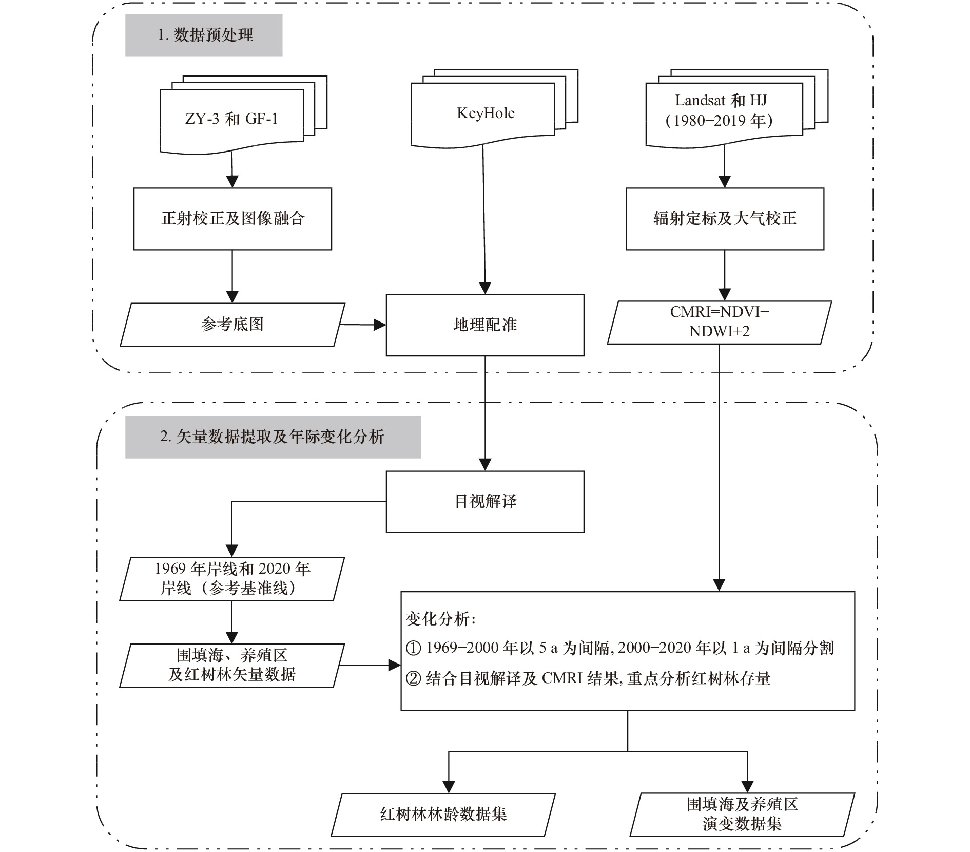
表 1 卫星遥感数据信息
Tab. 1 Remotely sensed data information
卫星 年份 分辨率/m 数量/景 KH-4A 1964 2.74 1 KH-4B 1967−1969 1.83 35 KH-9 1973 6~9 2 KH-9 1975 0.61~1.22 23 Landsat-3 1979 60 4 Landsat-5 1986−2010 30 52 HJ 2008−2017 30 16 Landsat-8 2013−2019 30 15 ZY-3 2020 2.1 14 GF-1 2020 2.1 7  下载: 导出CSV
-
[1] McKee K L, Cahoon D R, Feller I C. Caribbean mangroves adjust to rising sea level through biotic controls on change in soil elevation[J]. Global Ecology and Biogeography, 2007, 16(5): 545−556. doi: 10.1111/j.1466-8238.2007.00317.x [2] Bouillon S, Borges A V, Castañeda-Moya E, et al. Mangrove production and carbon sinks: a revision of global budget estimates[J]. Global Biogeochemical Cycles, 2008, 22(2): GB2013. [3] Dittmar T, Hertkorn N, Kattner G, et al. Mangroves, a major source of dissolved organic carbon to the oceans[J]. Global Biogeochemical Cycles, 2006, 20(1): GB1012. [4] Feller I C, Friess D A, Krauss K W, et al. The state of the world’s mangroves in the 21st century under climate change[J]. Hydrobiologia, 2017, 803(1): 1−12. doi: 10.1007/s10750-017-3331-z [5] Bradford J B, Birdsey R A, Joyce L A, et al. Tree age, disturbance history, and carbon stocks and fluxes in subalpine Rocky Mountain forests[J]. Global Change Biology, 2008, 14(12): 2882−2897. doi: 10.1111/j.1365-2486.2008.01686.x [6] Song Conghe, Woodcock C E. A regional forest ecosystem carbon budget model: impacts of forest age structure and landuse history[J]. Ecological Modelling, 2003, 164(1): 33−47. doi: 10.1016/S0304-3800(03)00013-9 [7] Chen Guangcheng, Gao Min, Pang Bopeng, et al. Top-meter soil organic carbon stocks and sources in restored mangrove forests of different ages[J]. Forest Ecology and Management, 2018, 422: 87−94. doi: 10.1016/j.foreco.2018.03.044 [8] Pregitzer K S, Euskirchen E S. Carbon cycling and storage in world forests: biome patterns related to forest age[J]. Global Change Biology, 2004, 10(12): 2052−2077. doi: 10.1111/j.1365-2486.2004.00866.x [9] 李森, 蔡厚才, 陈万东, 等. 海岸带生态恢复区不同林龄红树林对CH4和CO2排放通量的影响[J]. 生态环境学报, 2020, 29(12): 2414−2422.Li Sen, Cai Houcai, Chen Wandong, et al. Analysis on CH4 and CO2 fluxes of mangroves with different ages in the coastal ecological restoration zone[J]. Ecology and Environmental Sciences, 2020, 29(12): 2414−2422. [10] Giri C, Ochieng E, Tieszen L L, et al. Status and distribution of mangrove forests of the world using earth observation satellite data[J]. Global Ecology and Biogeography, 2011, 20(1): 154−159. doi: 10.1111/j.1466-8238.2010.00584.x [11] Bunting P, Rosenqvist A, Lucas R M, et al. The global mangrove watch—a new 2010 global baseline of mangrove extent[J]. Remote Sensing, 2018, 10(10): 1669. doi: 10.3390/rs10101669 [12] Lu Ying, Wang Le. How to automate timely large-scale mangrove mapping with remote sensing[J]. Remote Sensing of Environment, 2021, 264: 112584. doi: 10.1016/j.rse.2021.112584 [13] 王子予, 刘凯, 彭力恒, 等. 基于Google Earth Engine的1986−2018年广东红树林年际变化遥感分析[J]. 热带地理, 2020, 40(5): 881−892.Wang Ziyu, Liu Kai, Peng Liheng, et al. Analysis of mangrove annual changes in Guangdong Province during 1986−2018 based on Google Earth Engine[J]. Tropical Geography, 2020, 40(5): 881−892. [14] 吴培强, 马毅, 李晓敏, 等. 广东省红树林资源变化遥感监测[J]. 海洋学研究, 2011, 29(4): 16−24. doi: 10.3969/j.issn.1001-909X.2011.04.003Wu Peiqiang, Ma Yi, Li Xiaomin, et al. Remote sensing monitoring of the mangrove forests resources of Guangdong Province[J]. Journal of Marine Sciences, 2011, 29(4): 16−24. doi: 10.3969/j.issn.1001-909X.2011.04.003 [15] Jia Mingming, Wang Zongming, Wang Chao, et al. A new vegetation index to detect periodically submerged mangrove forest using single-tide sentinel-2 imagery[J]. Remote Sensing, 2019, 11(17): 2043. doi: 10.3390/rs11172043 [16] Zhang Tao, Hu Shanshan, He Yun, et al. A fine-scale mangrove map of china derived from 2-meter resolution satellite observations and field data[J]. ISPRS International Journal of Geo-Information, 2021, 10(2): 92. doi: 10.3390/ijgi10020092 [17] George-Chacón S P, Mas J F, Dupuy J M, et al. Mapping the spatial distribution of stand age and aboveground biomass from Landsat time series analyses of forest cover loss in tropical dry forests[J]. Remote Sensing in Ecology and Conservation, 2022, 8(3): 347−361. doi: 10.1002/rse2.247 [18] Zhang Quanfa, Pavlic G, Chen Wenjun, et al. Deriving stand age distribution in boreal forests using SPOT VEGETATION and NOAA AVHRR imagery[J]. Remote Sensing of Environment, 2004, 91(3/4): 405−418. [19] Razak J A B A, Shariff A R B M, Ahmad N B, et al. Mapping rubber trees based on phenological analysis of Landsat time series data-sets[J]. Geocarto International, 2018, 33(6): 627−650. [20] 张文秋, 房磊, 杨健, 等. 基于Landsat时间序列的湖南省会同县杉木人工林干扰历史重建与林龄估算[J]. 生态学杂志, 2018, 37(11): 3467−3479. doi: 10.13292/j.1000-4890.201811.033Zhang Wenqiu, Fang Lei, Yang Jian, et al. Reconstruction of stand-replacement disturbance and stand age of Chinese fir plantation based on a Landsat time series in Huitong County, Hunan[J]. Chinese Journal of Ecology, 2018, 37(11): 3467−3479. doi: 10.13292/j.1000-4890.201811.033 [21] Gupta K, Mukhopadhyay A, Giri S, et al. An index for discrimination of mangroves from non-mangroves using LANDSAT 8 OLI imagery[J]. MethodsX, 2018, 5: 1129−1139. doi: 10.1016/j.mex.2018.09.011 [22] 林玉英, 胡喜生, 邱荣祖, 等. 基于Landsat影像的NDVI对植被与影响因子交互耦合的响应[J]. 农业机械学报, 2018, 49(10): 212−219. doi: 10.6041/j.issn.1000-1298.2018.10.024Lin Yuying, Hu Xisheng, Qiu Rongzu, et al. Responses of landsat-based NDVI to interaction of vegetation and influencing factors[J]. Transactions of the Chinese Society for Agricultural Machinery, 2018, 49(10): 212−219. doi: 10.6041/j.issn.1000-1298.2018.10.024 [23] 唐少飞. 中国东北典型针叶林林龄信息提取及其对树种分类的影响研究[D]. 南京: 南京大学, 2020.Tang Shaofei. Study on extraction of stand age information of typical coniferous forests in Northeast China and its impact on tree species classification[D]. Nanjing: Nanjing University, 2020. [24] 国家海洋局908专项办公室. 我国近海海洋综合调查与评价专项: 海岛海岸带卫星遥感调查技术规程[M]. 北京: 海洋出版社, 2005.State Oceanic 908 of the State Oceanic Administration. the Investigation and the Evaluation of the State’s Coastal Sea: Technical Specification for Coastal Zone Investigation[M]. Beijing: China Ocean Press, 2005. [25] 浙江省质量技术监督局. 海岸线调查统计技术规范: DB33/T 2106−2018[S]. 杭州: 浙江省标准化研究院, 2018.Quality and Technology Supervision of Zhejiang Province. Specification for coastline survey statistics: DB33/T 2106−2018[S]. Hangzhou: Zhejiang Institute of Standardization, 2018. [26] 侯西勇, 毋亭, 侯婉, 等. 20世纪40年代初以来中国大陆海岸线变化特征[J]. 中国科学: 地球科学, 2016, 59(8): 1791−1802.Hou Xiyong, Wu Ting, Hou Wan, et al. Characteristics of coastline changes in mainland China since the early 1940s[J]. Science China: Earth Sciences, 2016, 59(8): 1791−1802. [27] 高志强, 刘向阳, 宁吉才, 等. 基于遥感的近30 a中国海岸线和围填海面积变化及成因分析[J]. 农业工程学报, 2014, 30(12): 140−147. doi: 10.3969/j.issn.1002-6819.2014.12.017Gao Zhiqiang, Liu Xiangyang, Ning Jicai, et al. Analysis on changes in coastline and reclamation area and its causes based on 30-year satellite data in China[J]. Transactions of the Chinese Society of Agricultural Engineering, 2014, 30(12): 140−147. doi: 10.3969/j.issn.1002-6819.2014.12.017 [28] 李矿明, 邓小飞, 韩维栋. 广东江门沿海红树林及其它湿地植被[J]. 中南林业调查规划, 2006, 25(1): 35−38. doi: 10.3969/j.issn.1003-6075.2006.01.010Li Kuangming, Deng Xiaofei, Han Weidong. Guangdong Jiangmen coastal mangrove and other wetland vegetation[J]. Central South Forest Inventory and Planning, 2006, 25(1): 35−38. doi: 10.3969/j.issn.1003-6075.2006.01.010 [29] 于凌云, 林绅辉, 焦学尧, 等. 粤港澳大湾区红树林湿地面临的生态问题与保护对策[J]. 北京大学学报(自然科学版), 2019, 55(4): 782−790. doi: 10.13209/j.0479-8023.2019.051Yu Lingyun, Lin Shenhui, Jiao Xueyao, et al. Ecological problems and protection countermeasures of mangrove wetland in Guangdong-Hong Kong-Macao greater bay area[J]. Acta Scientiarum Naturalium Universitatis Pekinensis, 2019, 55(4): 782−790. doi: 10.13209/j.0479-8023.2019.051 [30] 战国强. 珠江口红树林湿地保护与修复的基本思路[J]. 林业与环境科学, 2008, 24(6): 70−74. doi: 10.3969/j.issn.1006-4427.2008.06.015Zhan Guoqiang. Basic thought on mangrove wetland conservation planning in Pearl River Estuary[J]. Forestry and Environmental Science, 2008, 24(6): 70−74. doi: 10.3969/j.issn.1006-4427.2008.06.015 [31] 李海生, 吴灿雄, 欧阳美霞, 等. 广州市南沙区红树林资源现状与保护[J]. 湿地科学, 2020, 18(2): 158−165. doi: 10.13248/j.cnki.wetlandsci.2020.02.004Li Haisheng, Wu Canxiong, Ouyang Meixia, et al. The current status and conservation of mangrove resources in Nansha District of Guangzhou[J]. Wetland Science, 2020, 18(2): 158−165. doi: 10.13248/j.cnki.wetlandsci.2020.02.004 [32] 陈一萌, 杨阳. 惠州市红树林湿地资源及其保护[J]. 热带地理, 2010, 30(1): 34−39. doi: 10.3969/j.issn.1001-5221.2010.01.007Chen Yimeng, Yang Yang. Mangrove wetland resources and their protection scheme in Huizhou City[J]. Tropical Geography, 2010, 30(1): 34−39. doi: 10.3969/j.issn.1001-5221.2010.01.007 [33] 李海生. 深圳龙岗的红树林[J]. 广东教育学院学报, 2006, 26(3): 67−69.Li Haisheng. The mangrove of Longgang, Shenzhen[J]. Journal of Guangdong Education Institute, 2006, 26(3): 67−69. [34] 王金华, 温钊鹏. 粤港澳大湾区河口海岸生态修复策略研究——以东莞市滨海湾新区为例[J]. 海洋开发与管理, 2020, 37(6): 34−39. doi: 10.3969/j.issn.1005-9857.2020.06.007Wang Jinhua, Weng Zhaopeng. The ecological restoration strategy of estuary coastal zone in Guangdong-Hong Kong-Macao Greater Bay Area: take Dongguan Marina Bay New Area as an example[J]. Ocean Development and Management, 2020, 37(6): 34−39. doi: 10.3969/j.issn.1005-9857.2020.06.007 [35] 何锐荣. 澳门红树林及其保护研究[D]. 广州: 暨南大学, 2009.He Ruirong. Study on mangrove and its conservational strategy in Macao, China[D]. Guangzhou: Jinan University, 2009. [36] Brown M E, Pinzon J E, Didan K, et al. Evaluation of the consistency of long-term NDVI time series derived from AVHRR, SPOT-vegetation, SeaWiFS, MODIS, and Landsat ETM+ sensors[J]. IEEE Transactions on Geoscience and Remote Sensing, 2006, 44(7): 1787−1793. doi: 10.1109/TGRS.2005.860205 [37] 吴庭天, 丁山, 陈宗铸, 等. 基于LUCC和景观格局变化的海南东寨港红树林湿地动态研究[J]. 林业科学研究, 2020, 33(5): 154−162.Wu Tingtian, Ding Shan, Chen Zongzhu, et al. Dynamic analysis of mangrove wetlands based on LUCC and landscape pattern change in Dongzhai Port[J]. Forest Research, 2020, 33(5): 154−162. -


计量
- 文章访问数: 1484
- HTML全文浏览量: 382
- PDF下载量: 194
- 被引次数: 0
