

Evaluation of validity of bathymetry retrieval data based on high-spatial resolution remote sensing image
-
摘要: 卫星遥感反演水深(Satellite Derived Bathymetry, SDB)是获取浅海水深信息的有效手段。然而,其有效范围只限于光学浅水区域,在深水区域呈现“伪浅海”的失真现象。因此,如何准确识别SDB数据的有效范围对其广泛应用至关重要。本文基于高空间分辨率多光谱卫星影像,在深入分析深/浅水辐射亮度统计分布特征差异的基础上,提出一种数据驱动的水深反演有效性评价方法。该方法以卫星影像辐亮度信息的局域标准差作为特征,基于K-S检验方法对光学深水区域统计特征进行模型优选,并使用假设检验方法对深水无效区域对应的SDB进行识别。甘泉岛水域实验结果表明,该方法通过统计分布划分光学浅水与深水区域边界,可以有效识别光学深水区域产生的无效水深反演数据。在剔除无效区域数据后,光学浅水有效区域内水深反演平均绝对误差(MAE)为1.01,均方根误差(RMSE)为1.52。实验结果表明,本文提出的方法可准确识别SDB结果的有效区域,进而为浅海地形解译提供方法支撑。Abstract: Satellite derived bathymetric using multispectral imagery is an effective means to obtain shallow water depth information. However, its validity is limited to optical shallow water areas, but presents a “pseudo-shallow sea” distortion phenomenon in deep water areas. Therefore, accurately identifying the valid region of satellite derived bathymetry (SDB) data is crucial for its wide application. Based on high-spatial resolution remote sensing image, a data-driven method for evaluating the validity of SDB based on analysis of the differences in the statistical distribution of radiance in deep/shallow water regions is proposed in this paper. This method uses the local standard deviation of the radiance information of satellite images as a feature, optimizes the statistical characteristics of the optical deep water area based on the K-S test method, and uses the hypothesis test method to identify the SDB corresponding to the deep water invalid area. The experimental results in Ganquan Island region show that the method can effectively identify the invalid SDB associated with the optical deep water area by dividing the boundary between optical shallow and deep water area. After removing the invalid data, the mean absolute error (MAE) of SDB in the optical shallow region is 1.01, and the root mean square error (RMSE) is 1.52. The experimental results show that the proposed method can accurately identify the optical shallow region of SDB result, which benefits the interpretation and application of SDB results.
-
Key words:
- bathymetric retrieval /
- data validity /
- pseudo-shallow sea /
- optical shallow water area
1) ① a图审图号为GS(2016)1585号。 -

图 1 研究区域概况
a. 永乐环礁地理位置①;b. 永乐环礁卫星影像;c. 甘泉岛卫星影像
Fig. 1 Overview of the study area
a. Location of the Yongle Atoll; b. satellite image of Yongle Atoll; c. satellite image of Ganquan Island
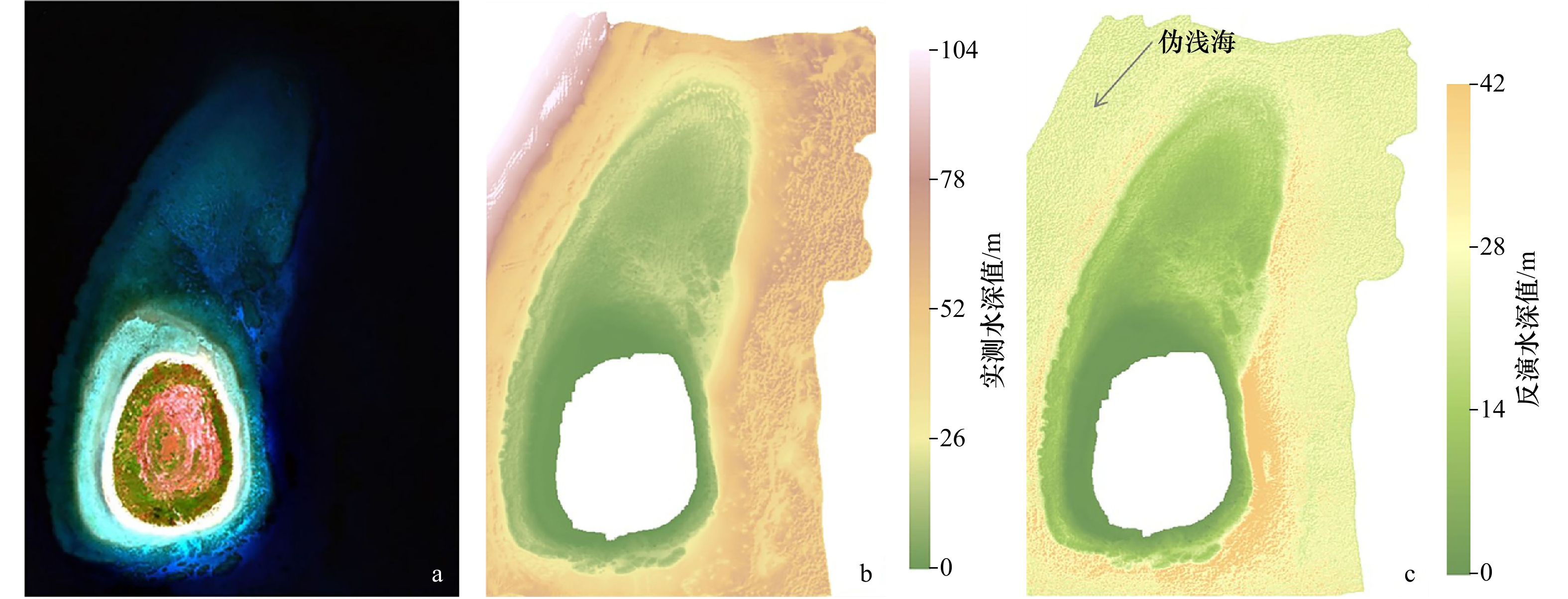
图 2 GeoEye-1遥感影像(a)、实测水深数据(b)和 Stumpf模型反演水深(c)
Fig. 2 GeoEye-1 sensing image (a), in-situ bathymetry data (b) and satellite derived bathymetry based on Stumpf model (c)

图 4 光学深/浅水区域辐亮度统计分布特征图
Fig. 4 Statistical distribution map of radiance in the optical shallow/deep water region

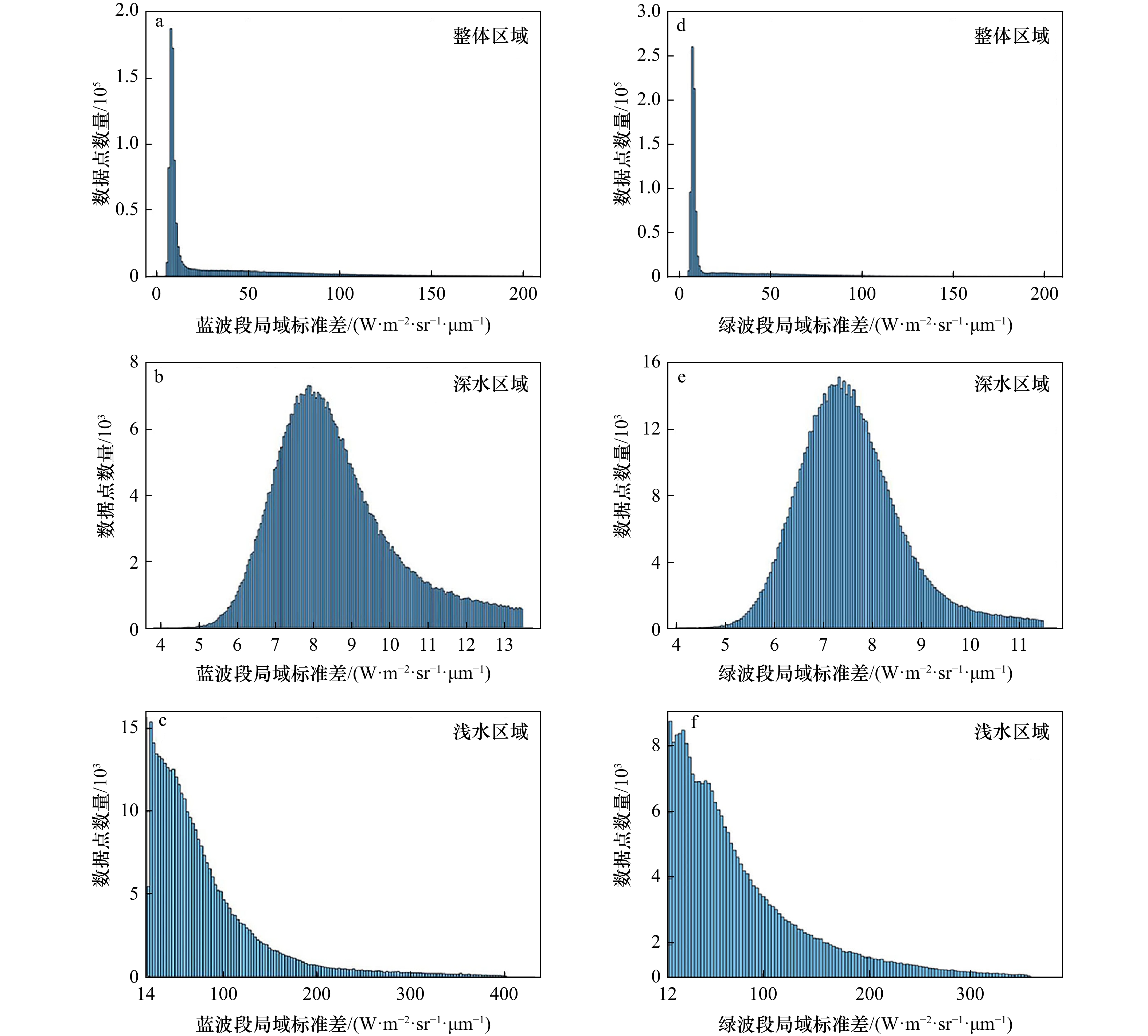
图 6 蓝、绿波段辐亮度数据及对应标准差特征分布
a. 蓝波段辐亮度;b. 绿波段辐亮度;c. 蓝波段辐亮度标准差特征分布;d. 绿波段辐亮度标准差特征分布
Fig. 6 Radiance data of blue/green bands and distribution of associated standard deviation features
a. Radiance of blue band; b. radiance of green band; c. distribution of radiance standard deviation feature of blue band; d. distribution of radiance standard deviation feature of green band
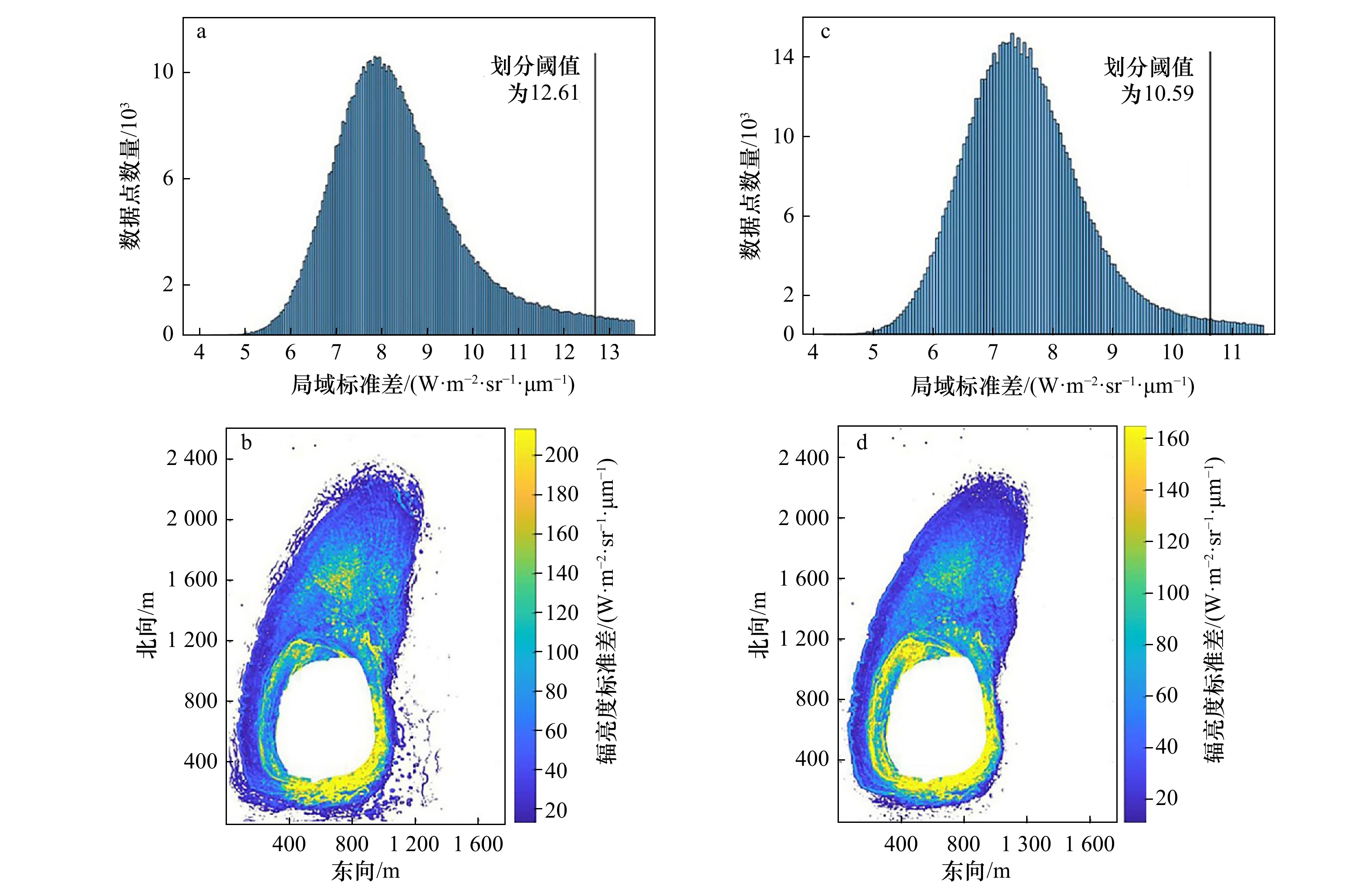
图 8 不同波段深/浅水区域划分阈值及划定的光学深水区域
a. 蓝波段划分阈值;b. 蓝波段确定深水区域;c. 绿波段划分阈值;d. 绿波段确定深水区域
Fig. 8 Different waveband deep/shallow water region division thresholds and delineated optical deep water regions
a. Blue band division threshold; b. blue band to determine deep water area; c. green band division threshold; d. green band to determine deep water area

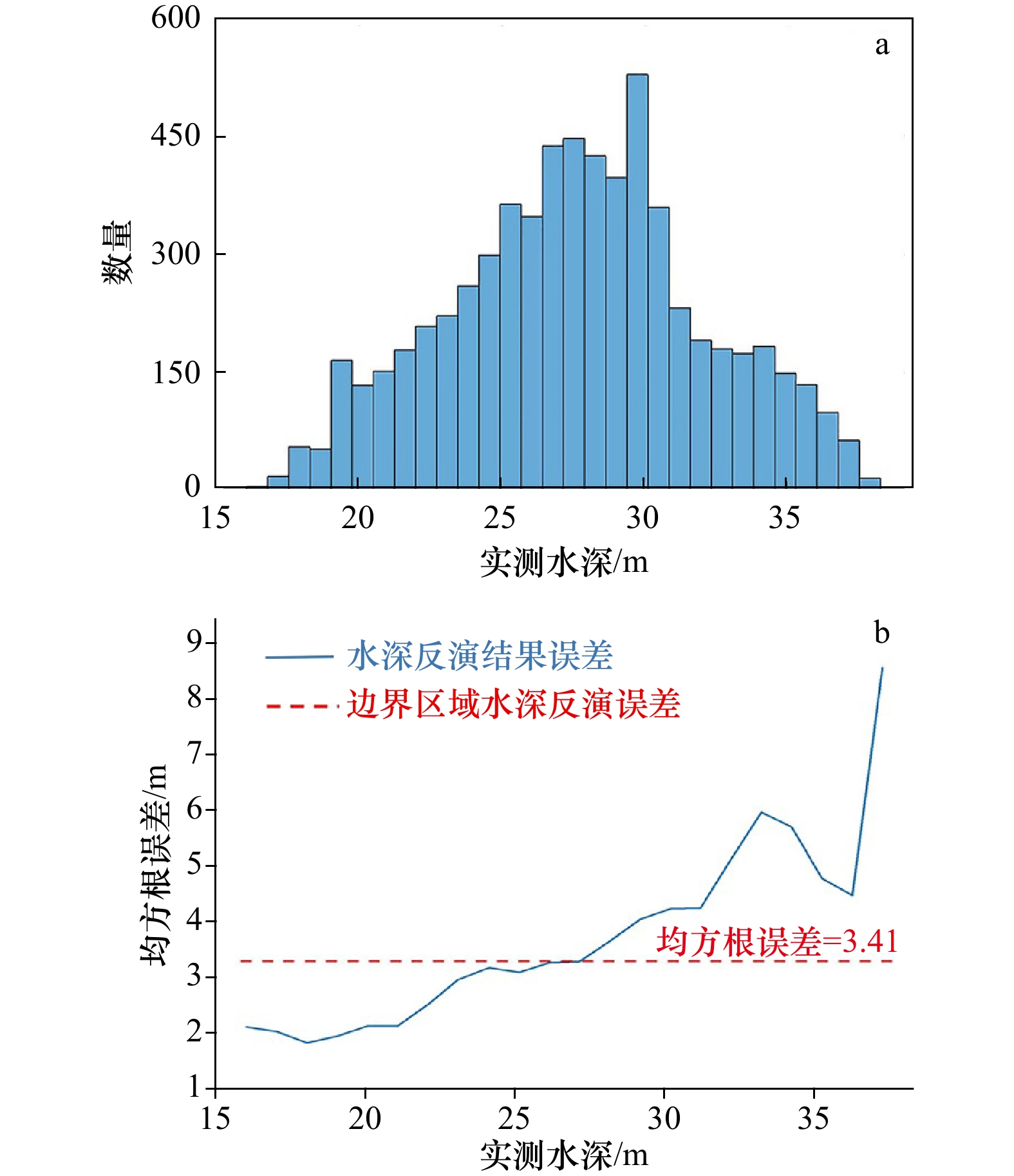
图 9 卫星遥感反演水深有效区域内信息分布
Fig. 9 Information distribution in the effective area of satellite derived bathymetry
表 1 5种候选统计分布的概率密度函数及标准差求解公式
Tab. 1 Probability density functions and standard deviation computation formula of five candidate statistical distributions
分布函数 瑞利分布 韦伯尔分布 正态分布 伽马分布 对数正态分布 概率密度函数 ${\dfrac{x}{v^2} {\rm{e}}^{-\frac{x^2}{2v^2} } }$ ${\dfrac{\sigma}{\lambda}x^{v-1}{\rm{e}}^{\frac{x^v}{\lambda} } }$ ${\dfrac{1}{\sqrt{2{\text{π}} v^2} }{\rm{e}}^{\frac{-(x-\lambda)^2}{2v^2} } }$ $\dfrac{\lambda^vx^{v-1} }{\varGamma(v)}{\rm{e}}^{-\lambda x}$ ${\dfrac{1}{\sqrt{2{\text{π}}}xv}{\rm{e}}^{-\frac{({\rm{ln}}\;x-\lambda)^2}{2v^2} } }$ 标准差 ${\sqrt{4-{{\text{π}} }/2v} }$ ${\lambda^{\frac{1}{v}} }$ 1.482 6×MAD(xi) ${\dfrac{1}{\lambda}\sqrt{v} }$ 1.482 6×MAD(ln xi) 注:MAD为中位数的绝对偏差。  下载: 导出CSV
表 2 K-S检验的拟合优度检验结果
Tab. 2 Test results of the goodness of fit of K-S test
分布函数
瑞利分布
韦伯尔分布
正态分布
伽马分布
对数正态分布蓝波段 0.32 0.11 0.08 0.06 0.04 绿波段 0.42 0.10 0.06 0.04 0.03 注:表中数据为最大偏差值,数值越小,拟合效果越好。
下载: 导出CSV
-
[1] 苏奋振, 杜云艳, 裴相斌, 等. 中国数字海洋构建基准与关键技术[J]. 地球信息科学, 2006, 8(1): 12−15.Su Fenzhen, Du Yunyan, Pei Xiangbin, et al. Constructing digital sea of China with the datum of coastal line[J]. Geo-Information Science, 2006, 8(1): 12−15. [2] 赵建虎, 欧阳永忠, 王爱学. 海底地形测量技术现状及发展趋势[J]. 测绘学报, 2017, 46(10): 1786−1794. doi: 10.11947/j.AGCS.2017.20170276Zhao Jianhu, Ouyang Yongzhong, Wang Aixue. Status and development tendency for seafloor terrain measurement technology[J]. Acta Geodaetica et Cartographica Sinica, 2017, 46(10): 1786−1794. doi: 10.11947/j.AGCS.2017.20170276 [3] Zavalas R, Ierodiaconou D, Ryan D, et al. Habitat classification of temperate marine macroalgal communities using bathymetric LiDAR[J]. Remote Sensing, 2014, 6(3): 2154−2175. doi: 10.3390/rs6032154 [4] Eren F, Pe’eri S, Rzhanov Y, et al. Bottom characterization by using airborne lidar bathymetry (ALB) waveform features obtained from bottom return residual analysis[J]. Remote Sensing of Environment, 2018, 206: 260−274. doi: 10.1016/j.rse.2017.12.035 [5] 杨必胜, 梁福逊, 黄荣刚. 三维激光扫描点云数据处理研究进展、挑战与趋势[J]. 测绘学报, 2017, 46(10): 1509−1516. doi: 10.11947/j.AGCS.2017.20170351Yang Bisheng, Liang Fuxun, Huang Ronggang. Progress, challenges and perspectives of 3D LiDAR point cloud processing[J]. Acta Geodaetica et Cartographica Sinica, 2017, 46(10): 1509−1516. doi: 10.11947/j.AGCS.2017.20170351 [6] Hodúl M, Bird S, Knudby A, et al. Satellite derived photogrammetric bathymetry[J]. ISPRS Journal of Photogrammetry and Remote Sensing, 2018, 142: 268−277. doi: 10.1016/j.isprsjprs.2018.06.015 [7] 马毅, 张杰, 张靖宇, 等. 浅海水深光学遥感研究进展[J]. 海洋科学进展, 2018, 36(3): 331−351. doi: 10.3969/j.issn.1671-6647.2018.03.001Ma Yi, Zhang Jie, Zhang Jingyu, et al. Progress in shallow water depth mapping from optical remote sensing[J]. Advances in Marine Science, 2018, 36(3): 331−351. doi: 10.3969/j.issn.1671-6647.2018.03.001 [8] 王艳姣, 董文杰, 张培群, 等. 水深可见光遥感方法研究进展[J]. 海洋通报, 2007, 26(5): 92−101. doi: 10.3969/j.issn.1001-6392.2007.05.015Wang Yanjiao, Dong Wenjie, Zhang Peiqun, et al. Progress in water depth mapping from visible remote sensing data[J]. Marine Science Bulletin, 2007, 26(5): 92−101. doi: 10.3969/j.issn.1001-6392.2007.05.015 [9] 党福星, 丁谦. 多光谱浅海水深提取方法研究[J]. 国土资源遥感, 2001(4): 53−58.Dang Fuxing, Ding Qian. A study of shallow water depth extraction using Landsat imagery[J]. Remote Sensing for Land & Resources, 2001(4): 53−58. [10] Lyzenga D R. Passive remote sensing techniques for mapping water depth and bottom features[J]. Applied Optics, 1978, 17(3): 379−383. doi: 10.1364/AO.17.000379 [11] Lee Z, Carder K L, Steward R G, et al. Remote sensing reflectance and inherent optical properties of oceanic waters derived from above-water measurements[C]//Proceedings of SPIE 2963, Ocean Optics XIII. Halifax: SPIE, 1997: 160 −166. [12] Lee Z, Carder K L, Mobley C D, et al. Hyperspectral remote sensing for shallow waters. I. A semianalytical model[J]. Applied Optics, 1998, 37(27): 6329−6338. doi: 10.1364/AO.37.006329 [13] Li Jiran, Zhang Huaguo, Hou Pengfei, et al. Mapping the bathymetry of shallow coastal water using single-frame fine-resolution optical remote sensing imagery[J]. Acta Oceanologica Sinica, 2016, 35(1): 60−66. doi: 10.1007/s13131-016-0797-x [14] Tanis F J, Byrne H J. Optimization of multispectral sensors for bathymetry applications[C]//Proceeding of 19th International Symposium on Remote Sensing of Environment, Ann Arbor, Michigan: Enviromental Research Institute, 1985: 865−874. [15] Chen Benqing, Yang Yanming, Xu Dewei, et al. A dual band algorithm for shallow water depth retrieval from high spatial resolution imagery with no ground truth[J]. ISPRS Journal of Photogrammetry and Remote Sensing, 2019, 151: 1−13. doi: 10.1016/j.isprsjprs.2019.02.012 [16] Xia Haoyang, Li Xiaorun, Zhang Huaguo, et al. A bathymetry mapping approach combining log-ratio and semianalytical models using four-band multispectral imagery without ground data[J]. IEEE Transactions on Geoscience and Remote Sensing, 2020, 58(4): 2695−2709. doi: 10.1109/TGRS.2019.2953381 [17] Liu Yongming, Tang Danling, Deng Ruru, et al. An adaptive blended algorithm approach for deriving bathymetry from multispectral imagery[J]. IEEE Journal of Selected Topics in Applied Earth Observations and Remote Sensing, 2020, 14: 801−817. [18] Paredes J M, Spero R E. Water depth mapping from passive remote sensing data under a generalized ratio assumption[J]. Applied Optics, 1983, 22(8): 1134−1135. doi: 10.1364/AO.22.001134 [19] 王燕红, 陈义兰, 周兴华, 等. 基于多项式回归模型的岛礁遥感浅海水深反演[J]. 海洋学报, 2018, 40(3): 121−128.Wang Yanhong, Chen Yilan, Zhou Xinghua, et al. Research on reef bathymetry using remote sensing based on polynomial regression model[J]. Haiyang Xuebao, 2018, 40(3): 121−128. [20] 陈本清, 杨燕明, 罗凯. 基于高分一号卫星多光谱数据的岛礁周边浅海水深遥感反演[J]. 热带海洋学报, 2017, 36(2): 70−78.Chen Benqing, Yang Yanming, Luo Kai. Retrieval of island shallow water depth from the GaoFen-1 multi-spectral imagery[J]. Journal of Tropical Oceanography, 2017, 36(2): 70−78. [21] 陈琛, 马毅, 张靖宇. GF-1 WFV图像经验模分解的光谱保真性与水深遥感探测[J]. 海洋学报, 2018, 40(4): 51−60.Chen Chen, Ma Yi, Zhang Jingyu. Spectral fidelity and water depth remote sensing detection of EMD of GF-1 WFV images[J]. Haiyang Xuebao, 2018, 40(4): 51−60. [22] Gholamalifard M, Kutser T, Esmaili-Sari A, et al. Remotely sensed empirical modeling of bathymetry in the southeastern Caspian Sea[J]. Remote Sensing, 2013, 5(6): 2746−2762. doi: 10.3390/rs5062746 [23] Stumpf R P, Holderied K, Sinclair M. Determination of water depth with high-resolution satellite imagery over variable bottom types[J]. Limnology and Oceanography, 2003, 48(1): 547−556. [24] 张鹰, 张东, 王艳姣, 等. 含沙水体水深遥感方法的研究[J]. 海洋学报, 2008, 30(1): 51−58.Zhang Ying, Zhang Dong, Wang Yanjiao, et al. Study of remote sensing-based bathymetric method in sand-containing water bodies[J]. Haiyang Xuebao, 2008, 30(1): 51−58. [25] Lyzenga D R. Remote sensing of bottom reflectance and water attenuation parameters in shallow water using aircraft and Landsat data[J]. International Journal of Remote Sensing, 1981, 2(1): 71−82. doi: 10.1080/01431168108948342 [26] 张鹰, 张芸, 张东, 等. 南黄海辐射沙脊群海域的水深遥感[J]. 海洋学报, 2009, 31(3): 39−45.Zhang Ying, Zhang Yun, Zhang Dong, et al. An underwater bathymetry reversion in the radial sand ridge group region of the southern Huanghai Sea using the remote sensing technology[J]. Haiyang Xuebao, 2009, 31(3): 39−45. [27] Lee Z, Shangguan M, Garcia R A, et al. Confidence measure of the shallow-water bathymetry map obtained through the fusion of Lidar and multiband image data[J]. International Journal of Remote Sensing, 2021, 2021: 9841804. [28] Hedley J D, Harborne A R, Mumby P J. Technical note: simple and robust removal of sun glint for mapping shallow-water benthos[J]. International Journal of Remote Sensing, 2005, 26(10): 2107−2112. doi: 10.1080/01431160500034086 [29] 邸凯昌, 丁谦, 陈薇, 等. 南沙群岛海域浅海水深提取及影像海图制作技术[J]. 国土资源遥感, 1999, 41(3): 59−64.Di Kaichang, Ding Qian, Chen Wei, et al. Shallow water depth extraction and chart production from tm images in Nansha islands and nearby sea area[J]. Remote Sensing for Land & Resources, 1999, 41(3): 59−64. [30] 平仲良. 可见光遥感测深的数学模型[J]. 海洋与湖沼, 1982, 13(3): 225−230.Ping Zhongliang. Mathematics model for visible remote sensing of water depth[J]. Oceanologia et Limnologia Sinica, 1982, 13(3): 225−230. [31] Brando V E, Dekker A G. Satellite hyperspectral remote sensing for estimating estuarine and coastal water quality[J]. IEEE Transactions on Geoscience and Remote Sensing, 2003, 41(6): 1378−1387. doi: 10.1109/TGRS.2003.812907 [32] Kvam P H, Vidakovic B. Nonparametric Statistics with Applications to Science and Engineering[M]. Wiley: Wiley InterScience, 2008. [33] Zhang K, Wang X, Wu Z, et al. Improving statistical uncertainty estimate of satellite-derived bathymetry by accounting for depth-dependent uncertainty[J]. IEEE Transactions on Geoscience and Remote Sensing, 2021, 60(99): 1−9. -


计量
- 文章访问数: 1300
- HTML全文浏览量: 458
- PDF下载量: 133
- 被引次数: 0
