The study of the trends of tidal amplitudes of major constituents in the South China Sea: A revisit
-
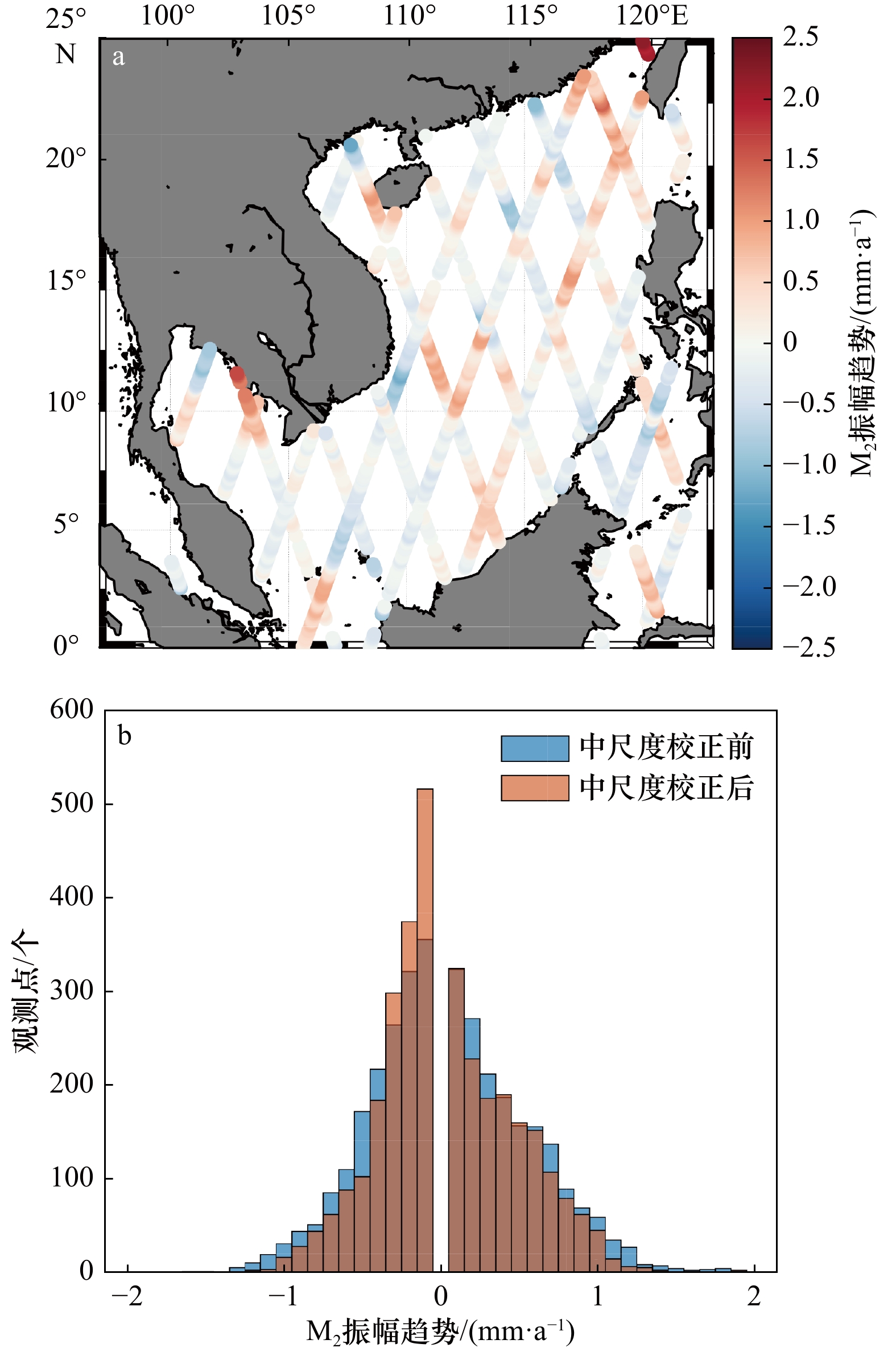
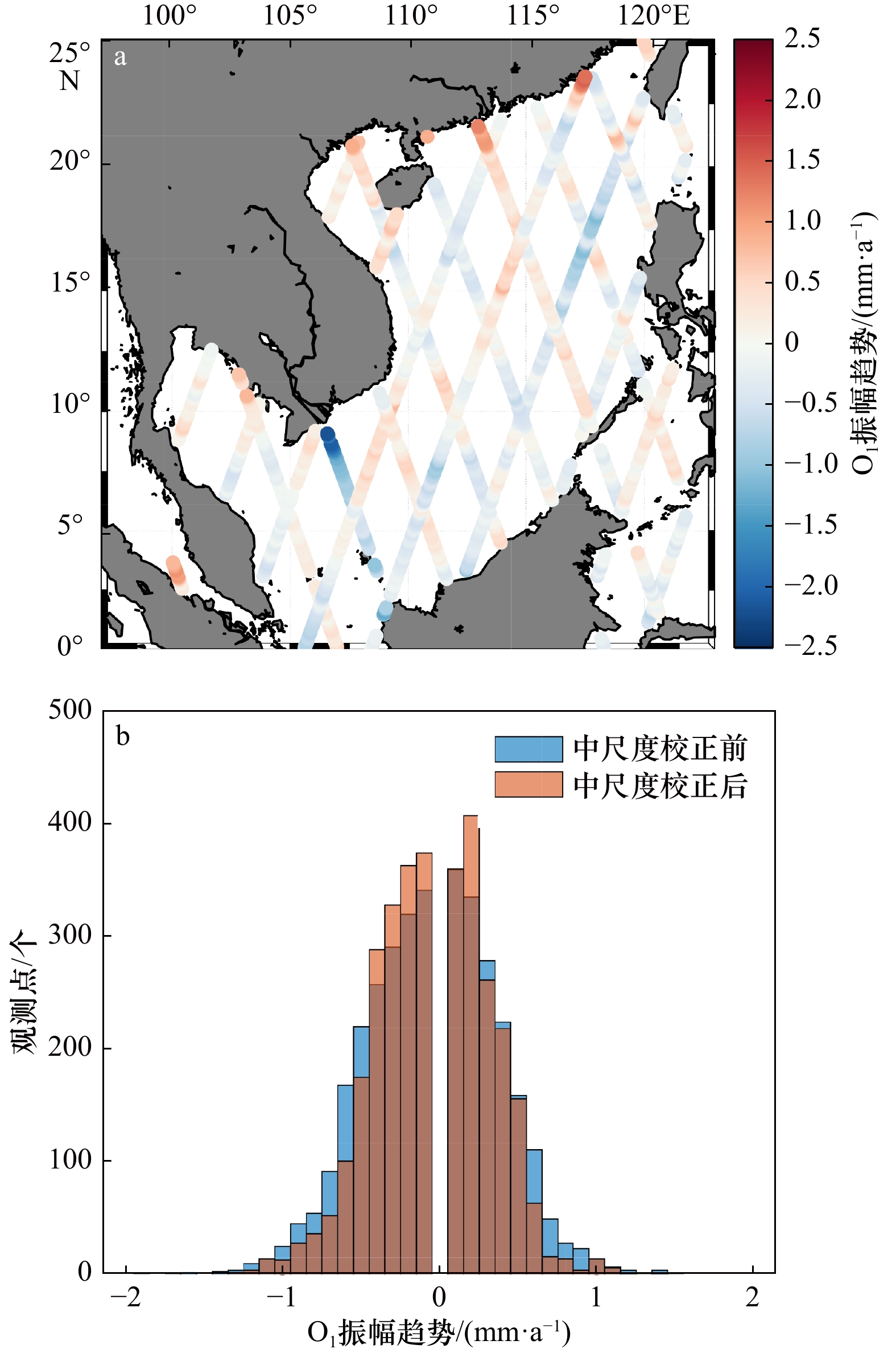
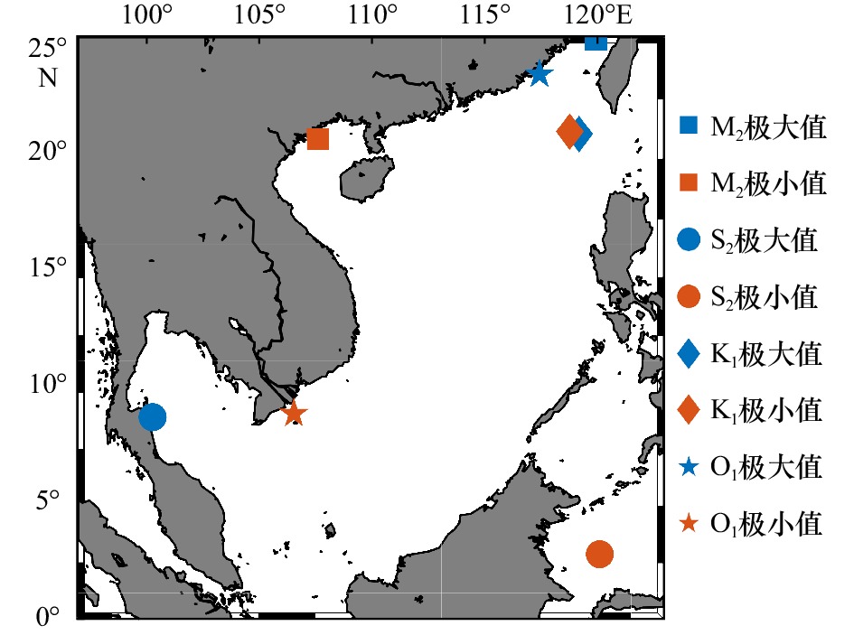
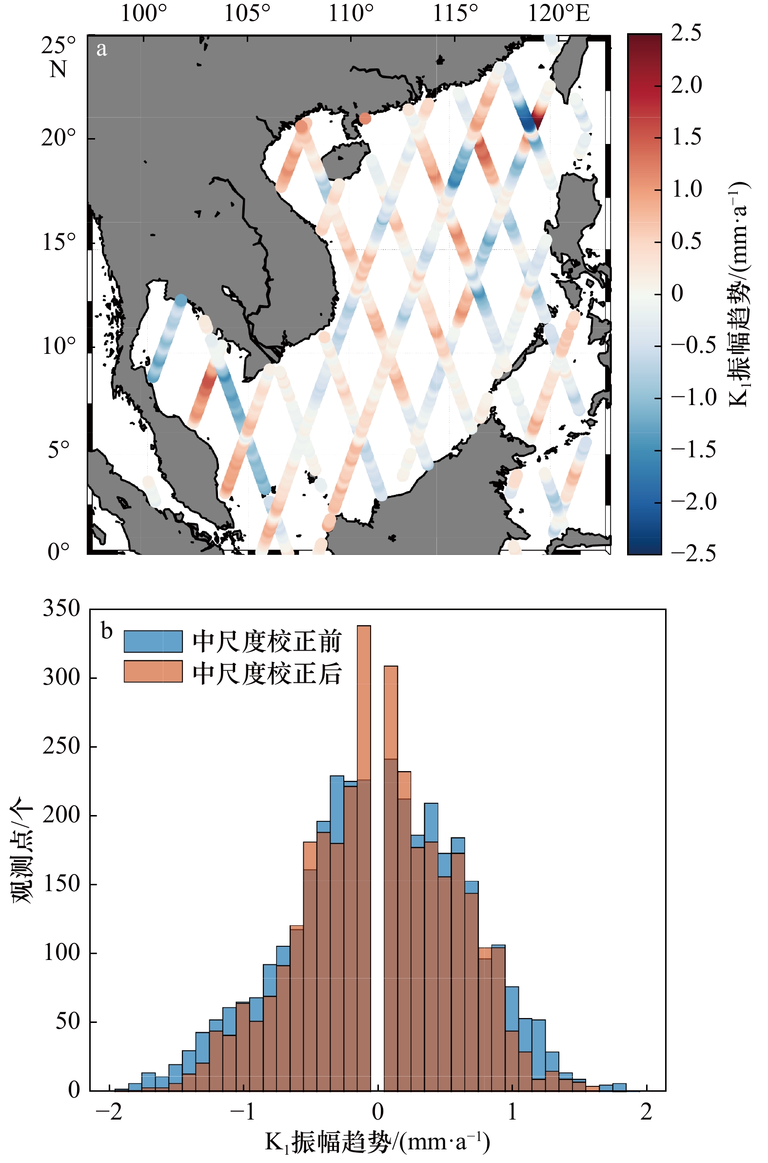
摘要: 潮汐变化研究对于沿海地区海洋工程、洪涝灾害预防和海洋资源开发利用等各方面都有着非常重要的意义。之前的潮汐变化研究主要基于多年逐时验潮站观测,而验潮站数据无论是站点的个数还是站点的位置,都存在很大的局限性,这对我们研究海盆尺度的潮汐变化规律形成了一定程度的阻碍。前人基于25年的T/P-Jason卫星高度计数据发现南海中央深海海盆主要分潮振幅存在异常大的趋势,这是由于中尺度海洋运动对潮汐调和分析干扰导致的虚假结果。本文首次使用了X-TRACK软件处理过的长达27年的T/P-Jason卫星高度计观测来研究整个南海的主要分潮振幅的长期趋势。经过X-TRACK处理后的卫星观测数据在整个南海的准确性和完整性都有了显著的提升。同时,我们使用了权重最小二乘法来消除长周期采样导致的潮汐混淆的影响。我们发现在南海大部分海域,4大主要分潮的振幅都存在显著的变化趋势。振幅和迟角变化的极值主要分布在吕宋海峡西部、马六甲海峡和台湾海峡等水深和岸线变化剧烈的近海海域,振幅最大的上升趋势可达2.75 mm/a,振幅最大的下降趋势可达–2.16 mm/a。南海主要分潮振幅的长期趋势与河流径流以及人类活动密切相关。Abstract: The research of tidal changes is vital to ocean engineering, the protection of flooding as well as the utilization of ocean resources in coastal areas. Previous studies are mainly based on long-term hourly tide gauges whose number and location are highly limited. Previous study indicated that the long-term trends of tidal amplitudes are abnormally large in the central deep basin of the South China Sea (SCS) based on 25-year satellite altimeter data, which is not realistic and the resultant of the interference of ocean mesoscale variability on tidal harmonic analysis. In this paper, we use 27-year T/P-Jason satellite altimeter data processed by X-TRACK software to study the long-term tidal trends in the SCS. The satellite altimeter data processed by X-TRACK obviously improves the accuracy and completeness of satellite data in the SCS. Meanwhile, the weighted least square method is used to eliminate the effect of tidal aliasing caused by long period sampling. We find that in most areas of the SCS, the amplitudes of four major tidal constituents have significant long-term trends. The significant positive and negative long-term trends of amplitudes and phases are mainly distributed in the coastal areas such as the western Luzon Strait, the Strait of Malacca and Taiwan Strait, where the water depth and shoreline change dramatically. The largest positive long-term trend of amplitudes can reach 2.75 mm/a and the largest negative long-term trend of amplitudes can reach −2.16 mm/a. The long-term trends of tidal amplitudes in the SCS should be related to river flow and human interference.
-
Key words:
- South China Sea /
- the long-term trend of tides /
- X-TRACK /
- satellite altimeter /
- S_TIDE
-
表 1 S_TIDE分辨的分潮的基本信息
Tab. 1 Tidal constituents resolved in S_TIDE
分潮 杜德森数 频率/h−1 Mn 0 0 0 0 1 0 0.000 006 129 Sa 0 0 1 0 0 –1 0.000 114 074 Ssa 0 0 2 0 0 0 0.000 228 159 Mf 0 2 0 0 0 0 0.003 050 092 Q1n 1 –2 0 1 –1 0 0.037 212 374 Q1 1 –2 0 1 0 0 0.037 218 503 O1n 1 –1 0 0 –1 0 0.038 724 526 O1 1 –1 0 0 0 0 0.038 730 654 P1 1 1 –2 0 0 0 0.041 552 587 K1 1 1 0 0 0 0 0.041 780 746 K1n 1 1 0 0 1 0 0.041 786 875 J1 1 2 0 –1 0 0 0.043 292 898 N2 2 –1 0 1 0 0 0.078 999 249 M2n 2 0 0 0 –1 0 0.080 505 272 M2 2 0 0 0 0 0 0.080 511 401 S2 2 2 –2 0 0 0 0.083 333 333 K2 2 2 0 0 0 0 0.083 561 492 K2n 2 2 0 0 1 0 0.083 567 624 M4 4 0 0 0 0 0 0.161 022 801 表 2 从T/P-Jason卫星高度计观测得到的南海主要分潮振幅的长期趋势统计结果
Tab. 2 The long-term trends of major constituents in the South China Sea obtained from T/P-Jason satellite altimeter data
分潮 趋势不显著的
观测点百分比/%上升趋势的
观测点百分比/%下降趋势的
观测点百分比/%所有观测点
趋势平均值
/(mm·a−1)所有观测点
趋势最大值
/(mm·a−1)所有观测点
趋势最小值
/(mm·a−1)M2 19.07 37.60 40.96 0.05 2.20 –1.23 S2 17.39 52.00 30.61 0.12 2.44 –1.63 K1 19.92 40.75 39.33 0.01 2.75 –2.16 O1 20.71 36.53 42.76 –0.05 1.48 –2.15 表 3 从T/P-Jason卫星高度计观测得到的南海主要分潮的迟角长期趋势统计结果
Tab. 3 The long-term trends of major tidal constituents’ phase in the South China Sea obtained from T/P-Jason satellite altimeter data
分潮 趋势不显著的
观测点百分比/%上升趋势的
观测点百分比/%下降趋势的
观测点百分比/%所有观测点
趋势最小值/((°)·a−1)所有观测点
趋势平均值/((°)·a−1)所有观测点
趋势最大值/((°)·a−1)趋势最大值
出现区域趋势最小值
出现区域M2 45.32 32.69 21.99 −0.92 0.04 1.01 新加坡东部 泰国湾 S2 25.89 43.88 30.23 −17.71 0.18 6.38 新加坡东部 新加坡东部 K1 44.82 24.64 30.51 −10.76 −10.01 0.58 泰国湾 泰国湾 O1 53.90 19.26 26.84 −10.70 0.002 3.53 马六甲海峡 马六甲海峡 -
[1] Woodworth P L. A survey of recent changes in the main components of the ocean tide[J]. Continental Shelf Research, 2010, 30(15): 1680−1691. doi: 10.1016/j.csr.2010.07.002 [2] Talke S A, Jay D A. Changing tides: the role of natural and anthropogenic factors[J]. Annual Review of Marine Science, 2020, 12: 121−151. doi: 10.1146/annurev-marine-010419-010727 [3] Doodson A T. Perturbations of harmonic tidal constants[J]. Proceedings of the Royal Society A: Mathematical, Physical and Engineering Sciences, 1924, 106(739): 513−526. [4] Godin G. Possibility of rapid changes in the tide of the Bay of Fundy, based on a scrutiny of the records from Saint John[J]. Continental Shelf Research, 1992, 12(2/3): 327−338. [5] Godin G. Rapid evolution of the tide in the Bay of Fundy[J]. Continental Shelf Research, 1995, 15(2/3): 369−372. [6] Cartwright D E. Secular changes in the oceanic tides at Brest, 1711−1936[J]. Geophysical Journal International, 1972, 30(4): 433−449. doi: 10.1111/j.1365-246X.1972.tb05826.x [7] DiLorenzo J L, Huang Poshu, Thatcher M L, et al. Dredging impacts on Delaware Estuary tides[C]//Proceedings of the 3rd International Conference on Estuarine and Coastal Modeling III. Oak Brook, IL: ASCE, 1993, 19: 86−104. [8] Flick R E, Murray J F, Ewing L C. Trends in United States tidal datum statistics and tide range[J]. Journal of Waterway, Port, Coastal, and Ocean Engineering, 2003, 129(4): 155−164. doi: 10.1061/(ASCE)0733-950X(2003)129:4(155) [9] Ray R D. Secular changes of the M2 tide in the gulf of Maine[J]. Continental Shelf Research, 2006, 26(3): 422−427. doi: 10.1016/j.csr.2005.12.005 [10] Pan Haidong, Lü Xianqing. Is there a Quasi 60-year oscillation in global tides?[J]. Continental Shelf Research, 2021, 222: 104433. doi: 10.1016/j.csr.2021.104433 [11] 王延强, 仉天宇, 朱学明. 基于18.6年卫星高度计资料对南海潮汐的分析与研究[J]. 海洋预报, 2014, 31(2): 35−40. doi: 10.11737/j.issn.1003-0239.2014.02.006Wang Yanqiang, Zhang Tianyu, Zhu Xueming. Tidal characteristics analysis in the South China Sea by 18.6 years satellite altimetry data[J]. Marine Forecasts, 2014, 31(2): 35−40. doi: 10.11737/j.issn.1003-0239.2014.02.006 [12] Pan Haidong, Guo Zheng, Lü Xianqing. Inversion of tidal open boundary conditions of the M2 constituent in the Bohai and Yellow Seas[J]. Journal of Atmospheric and Oceanic Technology, 2017, 34(8): 1661−1672. doi: 10.1175/JTECH-D-16-0238.1 [13] 潘海东, 王雨哲, 吕咸青. 南海潮汐主要分潮振幅变化趋势研究[J]. 海洋学报, 2021, 43(6): 26−34.Pan Haidong, Wang Yuzhe, Lü Xianqing. The study of the trends of tidal amplitudes of major constituents in the South China Sea[J]. Haiyang Xuebao, 2021, 43(6): 26−34. [14] Pan Haidong, Lü Xianqing, Wang Yingying, et al. Exploration of tidal-fluvial interaction in the Columbia River Estuary using S_TIDE[J]. Journal of Geophysical Research: Oceans, 2018, 123(9): 6598−6619. doi: 10.1029/2018JC014146 [15] Wang Daosheng, Pan Haidong, Jin Guangzhen, et al. Seasonal variation of the principal tidal constituents in the Bohai Sea[J]. Ocean Science, 2020, 16(1): 1−14. doi: 10.5194/os-16-1-2020 [16] Yu Qian, Pan Haidong, Gao Yanqiu, et al. The impact of the mesoscale ocean variability on the estimation of tidal harmonic constants based on satellite altimeter data in the South China Sea[J]. Remote Sensing, 2021, 13(14): 2736. doi: 10.3390/rs13142736 [17] Zhang Zhiwei, Zhao Wei, Tian Jiwei, et al. A mesoscale eddy pair southwest of Taiwan and its influence on deep circulation[J]. Journal of Geophysical Research: Oceans, 2013, 118(12): 6479−6494. doi: 10.1002/2013JC008994 [18] Gao Xiumin, Wei Zexun, Lü Xianqing, et al. Numerical study of tidal dynamics in the South China Sea with adjoint method[J]. Ocean Modelling, 2015, 92: 101−114. doi: 10.1016/j.ocemod.2015.05.010 [19] Birol F, Fuller N, Lyard F, et al. Coastal applications from nadir altimetry: example of the X-TRACK regional products[J]. Advances in Space Research, 2017, 59(4): 936−953. doi: 10.1016/j.asr.2016.11.005 [20] Vignudelli S, Birol F, Benveniste J, et al. Satellite altimetry measurements of sea level in the coastal zone[J]. Surveys in Geophysics, 2019, 40(6): 1319−1349. doi: 10.1007/s10712-019-09569-1 [21] Jin Guangzhen, Pan Haidong, Zhang Qilin, et al. Determination of harmonic parameters with temporal variations: an enhanced harmonic analysis algorithm and application to internal tidal currents in the South China Sea[J]. Journal of Atmospheric and Oceanic Technology, 2018, 35(7): 1375−1398. doi: 10.1175/JTECH-D-16-0239.1 [22] Pawlowicz R, Beardsley B, Lentz S. Classical tidal harmonic analysis including error estimates in MATLAB using T_TIDE[J]. Computers & Geosciences, 2002, 28(8): 929−937. [23] Guo Zheng, Pan Haidong, Fan Wei, et al. Application of surface spline interpolation in inversion of bottom friction coefficients[J]. Journal of Atmospheric and Oceanic Technology, 2017, 34(9): 2021−2028. doi: 10.1175/JTECH-D-17-0012.1 [24] Pan Haidong, Zheng Quanxin, Lü Xianqing. Temporal changes in the response of the nodal modulation of the M2 tide in the Gulf of Maine[J]. Continental Shelf Research, 2019, 186: 13−20. doi: 10.1016/j.csr.2019.07.007 [25] Cherniawsky J Y, Foreman M G G, Kang S K, et al. 18.6-year lunar nodal tides from altimeter data[J]. Continental Shelf Research, 2010, 30(6): 575−587. doi: 10.1016/j.csr.2009.10.002 [26] Piccioni G, Dettmering D, Schwatke C, et al. Design and regional assessment of an empirical tidal model based on FES2014 and coastal altimetry[J]. Advances in Space Research, 2021, 68(2): 1013−1022. doi: 10.1016/j.asr.2019.08.030 [27] Piccioni G, Dettmering D, Passaro M, et al. Coastal improvements for tide models: the impact of ALES retracker[J]. Remote Sensing, 2018, 10(5): 700. doi: 10.3390/rs10050700 [28] Pan Haidong, Guo Zheng, Wang Yingying, et al. Application of the EMD method to river tides[J]. Journal of Atmospheric and Oceanic Technology, 2018, 35(4): 809−819. doi: 10.1175/JTECH-D-17-0185.1 [29] Chant R J, Sommerfield C K, Talke S A. Impact of channel deepening on tidal and gravitational circulation in a highly engineered estuarine basin[J]. Estuaries and Coasts, 2018, 41(6): 1587−1600. doi: 10.1007/s12237-018-0379-6 [30] Familkhalili R, Talke S A. The effect of channel deepening on tides and storm surge: A case study of Wilmington, NC[J]. Geophysical Research Letters, 2016, 43(17): 9138−9147. doi: 10.1002/2016GL069494 -


 下载:
下载:
