Comparative study on shallow water depth inversion based on GeoEye-1 and WorldView-2 remote sensing data
-
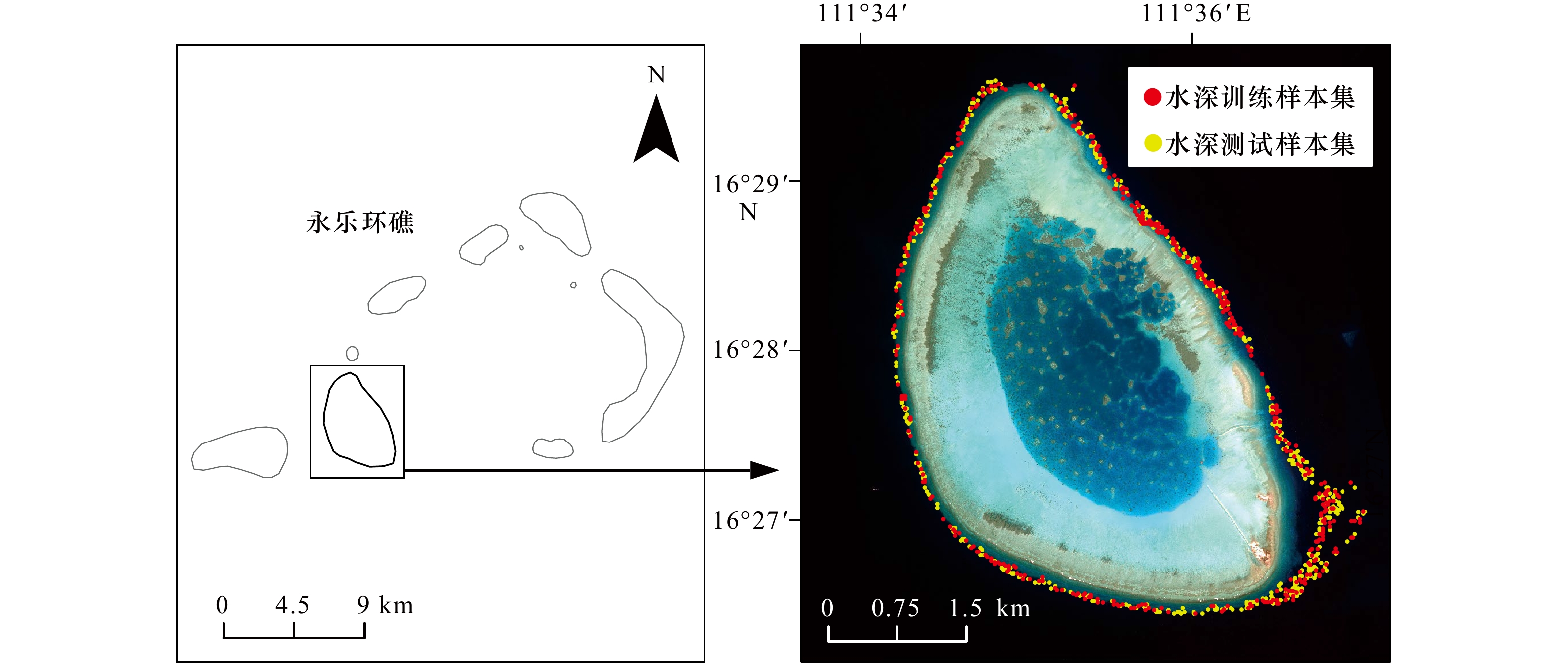
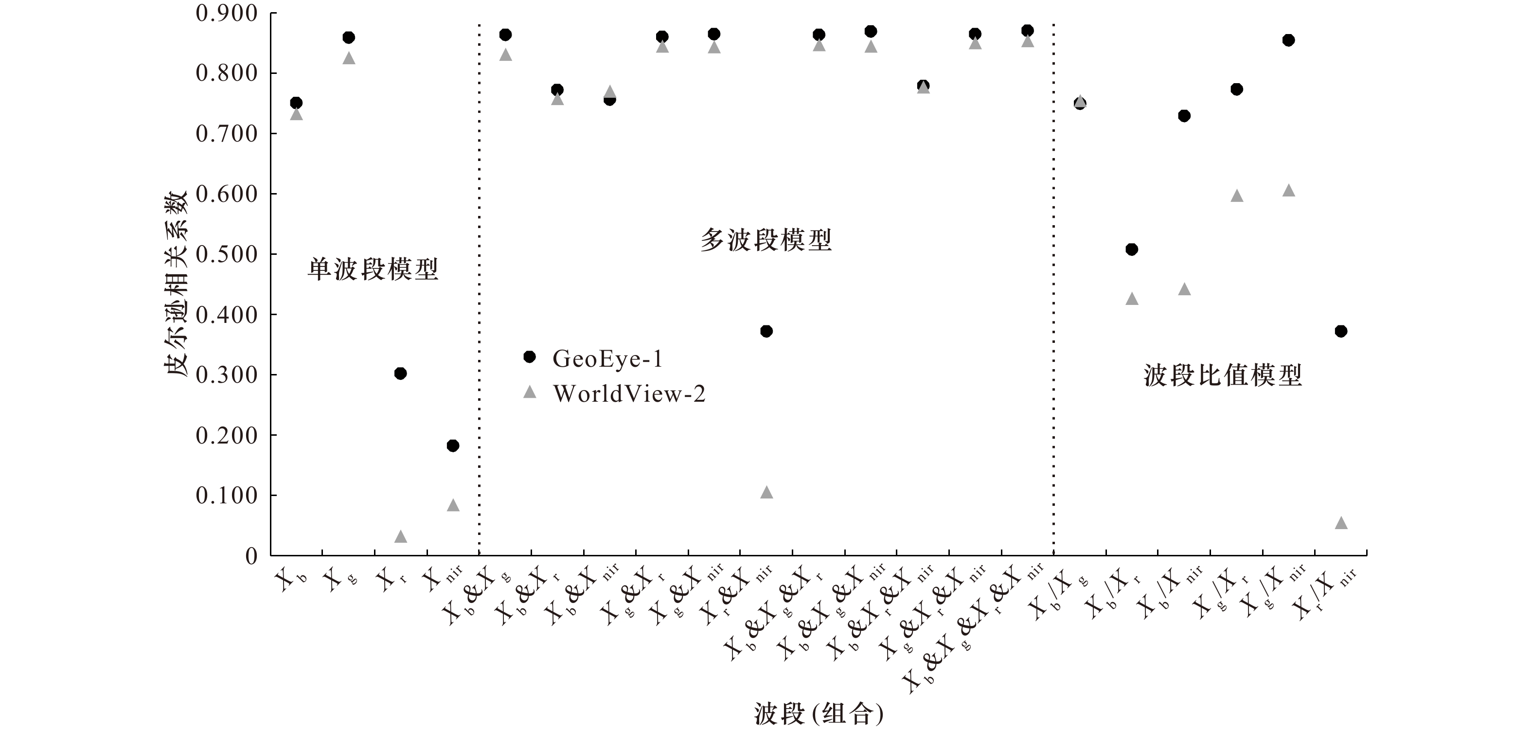
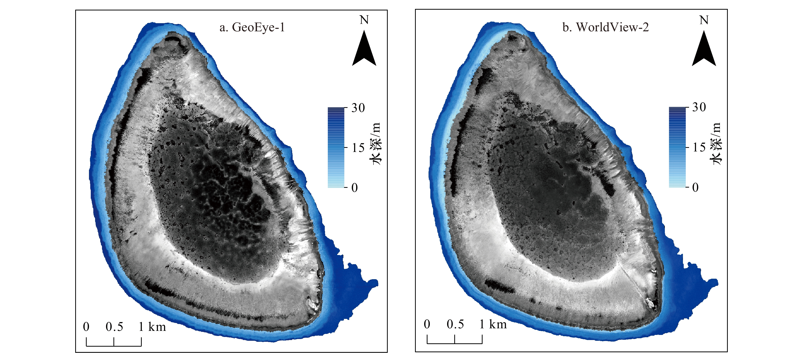
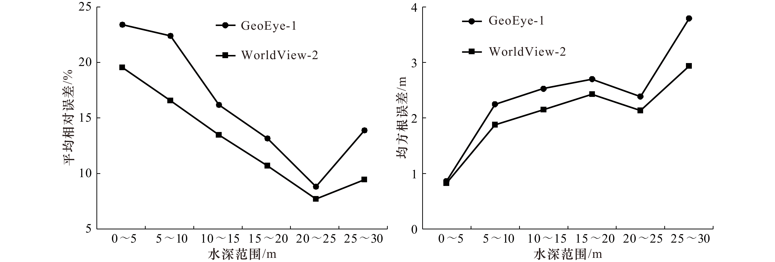
摘要: 浅海区水深的精确反演对于海洋空间管理和生态环境保护至关重要。选取南海西沙群岛的羚羊礁海域为研究区,基于GeoEye-1和WorldView-2高分辨率多光谱遥感数据和实测水深数据,分别建立了单波段模型、多波段模型和波段比值模型。结果显示,由绿波段参与建立的水深反演模型相关性普遍较高,同时利用4个波段组合建立的多波段模型精度最高,相关系数分别达到了0.870和0.853。基于该模型的反演结果对GeoEye-1和WorldView-2遥感数据在不同水深范围内的反演精度进行比较,结果表明,两种数据在不同水深范围内的反演误差变化趋势一致,平均相对误差最大值均出现在0~5 m,而最小值均出现在20~25 m。总体而言,WorldView-2影像反演水深的精度高于GeoEye-1影像的反演精度。研究对于热带浅海区的水深反演工作具有一定的参考意义。Abstract: Accurate inversion of shallow water depth is essential for marine space management and ecological environment protection. Lingyang Reef of Xisha Islands in the South China Sea is taken as a typical study area. The single-band model, multi-band model and band-ratio model are established based on GeoEye-1 and WorldView-2 high-resolution multi-spectral remote sensing data and measured points. The results show that the correlation of the inversion model established with the participation of green band is generally high, while the multi-band model established by four bands combination has the highest accuracy and the correlation coefficient reaches 0.870 and 0.853, respectively. Comparing with the inversion accuracy of GeoEye-1 and WorldView-2 data in different depth ranges based on the above model, the conclusion is that the inversion errors of the two kinds of data in different depth ranges have the same trend, with the maximum value of the average relative errors occurring in the range of 0−5 m and the minimum value occurring in the range of 20−25 m. In general, the inversion accuracy of WorldView-2 image is higher than that of GeoEye-1 image. This study has a certain reference significance for the inversion of water depth in shallow tropical sea.
-
表 1 遥感卫星数据参数
Tab. 1 Remote sensing satellite data parameters
参数 GeoEye-1 WorldView-2 获取时间 2017年2月18日 2019年7月15日 波长范围/nm 波段1(蓝):450~510
波段2(绿):510~580
波段3(红):655~690
波段4(近红外):780~920波段1(海岸):400~450
波段2(蓝):450~510
波段3(绿):510~580
波段4(黄):585~625
波段5(红):630~690
波段6(红边):705~745
波段7(近红外):770~895
波段8(近红外):860~1 040空间分辨率/m 1.65 1.80 表 2 水深反演模型及其决定系数
Tab. 2 Water depth inversion model and its determination coefficients
模型 GeoEye-1 WorldView-2 拟合公式 决定系数 拟合公式 决定系数 单波段
模型y=−15.618ln(Xb)+121.290 0.563 y=−19.630ln(Xb)+153.310 0.537 y=−11.989ln(Xg)+90.712 0.738 y=−14.280ln(Xg)+109.510 0.680 y=−9.770ln(Xr)+64.625 0.091 y=0.427ln(Xr)+19.500 0.001 y=8.866ln(Xnir)−12.766 0.033 y=1.120ln(Xnir)+17.337 0.007 多波段
模型y=4.179ln(Xb)–14.544ln(Xg)+78.751 0.745 y=6.573ln(Xb)–18.234ln(Xg)+89.696 0.689 y=−14.985ln(Xb)–5.847ln(Xr)+143.192 0.595 y=−21.155ln(Xb)–4.477ln(Xr)+181.884 0.573 y=−15.385ln(Xb)+4.275ln(Xnir)+103.399 0.571 y=20.910ln(Xb)+3.227ln(Xnir)+150.687 0.592 y=−11.957ln(Xg)–0.212ln(Xr)+91.471 0.739 y=15.027ln(Xg)–4.056ln(Xr)+130.695 0.712 y=−11.854ln(Xg)+4.770ln(Xnir)+71.632 0.748 y=−14.617ln(Xg) +2.369ln(Xnir)+103.316 0.711 y=−10.565ln(Xr)+10.653ln(Xnir)+27.285 0.138 y=1.674ln(Xr)+1.607ln(Xnir)+8.803 0.011 y=4.745ln(Xb)–15.041ln(Xg)+1.010ln(Xr)+73.513 0.746 y=4.415ln(Xb)–17.636ln(Xg)–3.811ln(Xr)+116.107 0.716 y=4.670ln(Xb)–14.698ln(Xg)+5.180ln(Xnir)+56.621 0.756 y=3.433ln(Xb)–16.656ln(Xg)+2.198ln(Xnir)+93.418 0.713 y=−14.626ln(Xb)–6.357ln(Xr)+5.577ln(Xnir)+121.762 0.607 y=−21.520ln(Xb)–2.591ln(Xr)+2.539ln(Xnir)+167.786 0.603 y =−11.736ln(Xg)–0.757ln(Xr)+4.938ln(Xnir) +73.666 0.748 y=−15.025ln(Xg)–2.823ln(Xr)+1.587ln(Xnir)+120.108 0.723 y=4.942ln(Xb)–14.941ln(Xg)+0.499ln(Xr)+5.093ln(Xnir)+54.407 0.757 y=2.926ln(Xb)–16.754ln(Xg)–2.761ln(Xr)+1.458ln(Xnir)+111.300 0.727 波段比
值模型${y=21.978{\rm{ln}} \left( {\dfrac{{{X_{\rm{b}}}}}{{{X_{\rm{g}}}}}} \right)+7.811 }$ 0.561 ${y=28.096 \ln \left( {\dfrac{{{X_{\rm{b}}}}}{{{X_{\rm{g}}}}}} \right) +5.834}$ 0.569 ${y=-9.668\ln \left( {\dfrac{{{X_{\rm{b}}}}}{{{X_{\rm{r}}}}}} \right) +40.248}$ 0.258 $ {y=-6.429\ln\left( {\dfrac{{{X_{\rm{b}}}}}{{{X_{\rm{r}}}}}} \right) +38.193}$ 0.182 ${y=-13.35\ln \left( {\dfrac{{{X_{\rm{b}}}}}{{{X_{{\rm{nir}}}}}} } \right)+55.538}$ 0.531 ${y=-5.798\ln \left( {\dfrac{{{X_{\rm{b}}}}}{{{X_{{\rm{nir}}}}}} } \right)+40.067}$ 0.195 ${y=-11.45\ln \left( {\dfrac{{{X_{\rm{g}}}}}{{{X_{\rm{r}}}}} } \right)+36.747}$ 0.598 ${y=-7.341\ln \left( {\dfrac{{{X_{\rm{g}}}}}{{{X_{\rm{r}}}}} } \right)+36.571}$ 0.356 ${y=-11.17\ln\left( \dfrac{ { {X_{\rm{g} } } }}{ {X_{ {\rm{nir} } } }} \right)+43.112}$ 0.730 ${y=-6.814\ln\left( \dfrac{ { {X_{\rm{g} } } }}{ {X_{ {\rm{nir} } } } } \right)+39.628}$ 0.367 ${y=-10.59\ln\left( \dfrac{ { {X_{\rm{r} } } }}{ {X_{ {\rm{nir} } } }} \right)+27.64}$ 0.138 ${y=-0.494\ln\left( \dfrac{ { {X_{\rm{r} } } }}{ {X_{ {\rm{nir} } } }} \right)+21.547}$ 0.003 注:Xb、Xg、Xr、Xnir分别为蓝波段、绿波段、红波段、近红外波段的反射率。 表 3 不同水深范围的反演误差
Tab. 3 Inversion error of different depth ranges
水深范围/m 平均相对误差/% 均方根误差/m GeoEye-1 WorldView-2 GeoEye-1 WorldView-2 0~5 23.43 19.56 0.87 0.83 5~10 22.42 16.60 2.25 1.88 10~15 16.19 13.50 2.53 2.15 15~20 13.19 10.71 2.70 2.43 20~25 8.85 7.73 2.39 2.14 25~30 13.90 9.47 3.79 2.94 0~30 12.58 10.40 2.70 2.53 -
[1] Li Jiwei, Knapp D E, Schill S R, et al. Adaptive bathymetry estimation for shallow coastal waters using Planet Dove satellites[J]. Remote Sensing of Environment, 2019, 232: 111302. doi: 10.1016/j.rse.2019.111302 [2] Hsu H J, Huang C Y, Jasinski M, et al. A semi-empirical scheme for bathymetric mapping in shallow water by ICESat-2 and Sentinel-2: a case study in the South China Sea[J]. ISPRS Journal of Photogrammetry and Remote Sensing, 2021, 178: 1−19. doi: 10.1016/j.isprsjprs.2021.05.012 [3] Gao J. Bathymetric mapping by means of remote sensing: methods, accuracy and limitations[J]. Progress in Physical Geography, 2009, 33(1): 103−116. doi: 10.1177/0309133309105657 [4] Jawak S D, Vadlamani S S, Luis A J. A synoptic review on deriving bathymetry information using remote sensing technologies: models, methods and comparisons[J]. Advances in Remote Sensing, 2015, 4(2): 147−162. doi: 10.4236/ars.2015.42013 [5] Su Haibin, Liu Hongxing, Wu Qiusheng. Prediction of water depth from multispectral satellite imagery—the regression Kriging alternative[J]. IEEE Geoscience and Remote Sensing Letters, 2015, 12(12): 2511−2515. doi: 10.1109/LGRS.2015.2489678 [6] Civco D L, Kennard W C. Satellite remote bathymetry: a new mechanism for modeling[J]. Photogrammetric Engineering and Remote Sensing, 1992, 58(5): 545−549. [7] Paredes J M, Spero R E. Water depth mapping from passive remote sensing data under a generalized ratio assumption[J]. Applied Optics, 1983, 22(8): 1134−1135. doi: 10.1364/AO.22.001134 [8] Stumpf R P, Holderied K, Sinclair M. Determination of water depth with high-resolution satellite imagery over variable bottom types[J]. Limnology and Oceanography, 2003, 48(1): 547−556. [9] 马毅, 张杰, 张靖宇, 等. 浅海水深光学遥感研究进展[J]. 海洋科学进展, 2018, 36(3): 331−351. doi: 10.3969/j.issn.1671-6647.2018.03.001Ma Yi, Zhang Jie, Zhang Jingyu, et al. Progress in shallow water depth mapping from optical remote sensing[J]. Advances in Marine Science, 2018, 36(3): 331−351. doi: 10.3969/j.issn.1671-6647.2018.03.001 [10] Cheng Jie, Ma Yi, Zhang Jingyu. Water-depth-zoning inversion based on the relationship between two-band radiance data and the depth-invariant index[J]. Regional Studies in Marine Science, 2021, 44: 101790. doi: 10.1016/j.rsma.2021.101790 [11] Liceaga-Correa M A, Euan-Avila J I. Assessment of coral reef bathymetric mapping using visible Landsat Thematic Mapper data[J]. International Journal of Remote Sensing, 2002, 23(1): 3−14. doi: 10.1080/01431160010008573 [12] Lu Tianqi, Chen Shengbo, Tu Yuan, et al. Comparative study on coastal depth inversion based on multi-source remote sensing data[J]. Chinese Geographical Science, 2019, 29(2): 192−201. doi: 10.1007/s11769-018-1013-z [13] Liu Yongming, Tang Danling, Deng Ruru, et al. An adaptive blended algorithm approach for deriving bathymetry from multispectral imagery[J]. IEEE Journal of Selected Topics in Applied Earth Observations and Remote Sensing, 2020, 14: 801−817. [14] 聂荣娟. 基于Worldview3数据的浅海水深反演研究[J]. 北京测绘, 2019, 33(9): 1081−1086.Nie Rongjuan. Deep seawater inversion based on Worldview3 data[J]. Beijing Surveying and Mapping, 2019, 33(9): 1081−1086. [15] 王燕红, 陈义兰, 周兴华, 等. 基于多项式回归模型的岛礁遥感浅海水深反演[J]. 海洋学报, 2018, 40(3): 121−128.Wang Yanhong, Chen Yilan, Zhou Xinghua, et al. Research on reef bathymetry using remote sensing based on polynomial regression model[J]. Haiyang Xuebao, 2018, 40(3): 121−128. [16] 韩中含, 徐白山, 杨成林, 等. 基于Planet多光谱影像的南海岛礁水深反演研究[J]. 测绘与空间地理信息, 2020, 43(12): 139−142,146. doi: 10.3969/j.issn.1672-5867.2020.12.039Han Zhonghan, Xu Baishan, Yang Chenglin, et al. Research on reef depth retrieval of South China Sea island based on Planet multispectral image[J]. Geomatics & Spatial Information Technology, 2020, 43(12): 139−142,146. doi: 10.3969/j.issn.1672-5867.2020.12.039 [17] Casal G, Hedley J D, Monteys X, et al. Satellite-derived bathymetry in optically complex waters using a model inversion approach and Sentinel-2 data[J]. Estuarine, Coastal and Shelf Science, 2020, 241: 106814. doi: 10.1016/j.ecss.2020.106814 [18] 陈本清, 杨燕明, 罗凯. 基于高分一号卫星多光谱数据的岛礁周边浅海水深遥感反演[J]. 热带海洋学报, 2017, 36(2): 70−78.Chen Benqing, Yang Yanming, Luo Kai. Retrieval of island shallow water depth from the GaoFen-1 multi-spectral imagery[J]. Journal of Tropical Oceanography, 2017, 36(2): 70−78. [19] Xia Haoyang, Li Xiaorun, Zhang Huaguo, et al. A bathymetry mapping approach combining log-ratio and semianalytical models using four-band multispectral imagery without ground data[J]. IEEE Transactions on Geoscience and Remote Sensing, 2020, 58(4): 2695−2709. doi: 10.1109/TGRS.2019.2953381 [20] 冯英辞, 詹文欢, 姚衍桃, 等. 西沙群岛礁区的地质构造及其活动性分析[J]. 热带海洋学报, 2015, 34(3): 48−53. doi: 10.3969/j.issn.1009-5470.2015.03.006Feng Yingci, Zhan Wenhuan, Yao Yantao, et al. Analysis of tectonic movement and activity in the organic reef region around the Xisha Islands[J]. Journal of Tropical Oceanography, 2015, 34(3): 48−53. doi: 10.3969/j.issn.1009-5470.2015.03.006 [21] 陈玲, 陈理, 李伟, 等. 基于FLAASH模型的Worldview3大气校正[J]. 国土资源遥感, 2019, 31(4): 26−31.Chen Ling, Chen Li, Li Wei, et al. Atmospheric correction of Worldview3 image based on FLAASH model[J]. Remote Sensing for Land & Resources, 2019, 31(4): 26−31. [22] 陆天启, 陈圣波, 郭甜甜, 等. 基于SPOT-6遥感影像的近海水深反演[J]. 海洋学研究, 2016, 34(3): 51−56.Lu Tianqi, Chen Shengbo, Guo Tiantian, et al. Offshore bathymetry retrieval from SPOT-6 image[J]. Journal of Marine Sciences, 2016, 34(3): 51−56. [23] 赵洪臣. 基于WorldView-2的多级决策的光学遥感水深反演方法研究[D]. 南京: 南京大学, 2017.Zhao Hongchen. Water depth inversion method of optical remote sensing using multilevel decision-making scheme based on WorldView-2[D]. Nanjing: Nanjing University, 2017. [24] 潘昀, 程永舟, 李青峰, 等. 破碎波作用下沙坝附近悬浮泥沙浓度试验研究[J]. 人民长江, 2013, 44(21): 71−75. doi: 10.3969/j.issn.1001-4179.2013.21.019Pan Yun, Cheng Yongzhou, Li Qingfeng, et al. Experimental study on suspended sediment concentration near sand bars under action of breaking waves[J]. Yangtze River, 2013, 44(21): 71−75. doi: 10.3969/j.issn.1001-4179.2013.21.019 -


 下载:
下载:


