Study on the chlorophyll a concentration retrieved from HY-1C satellite coastal zone imager data
-
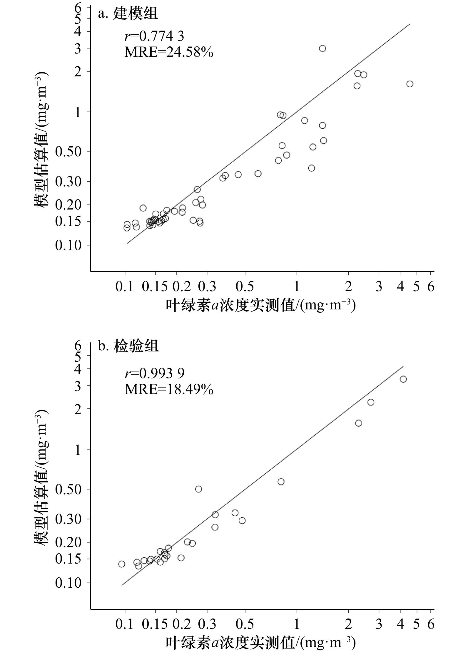
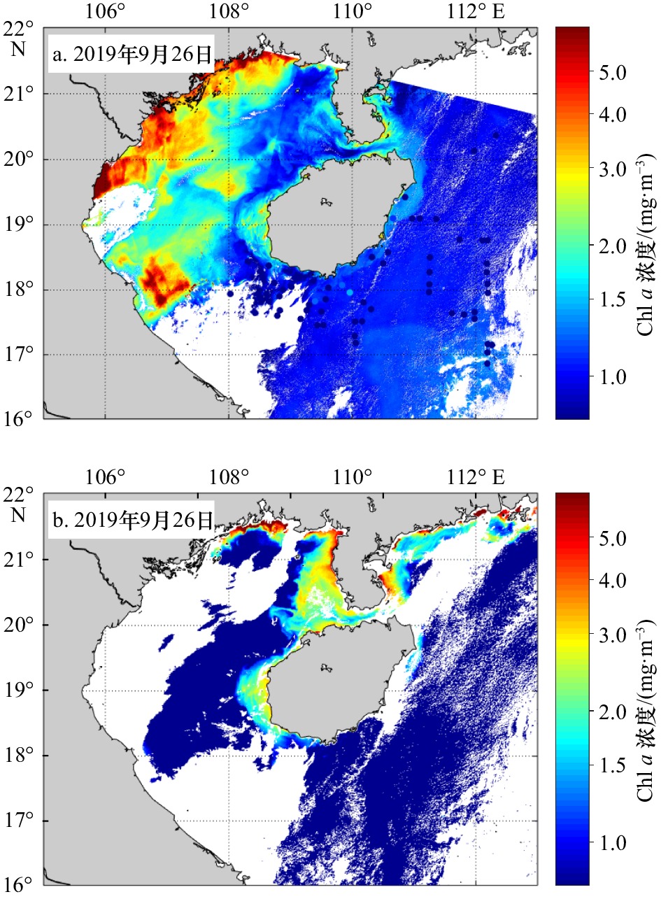
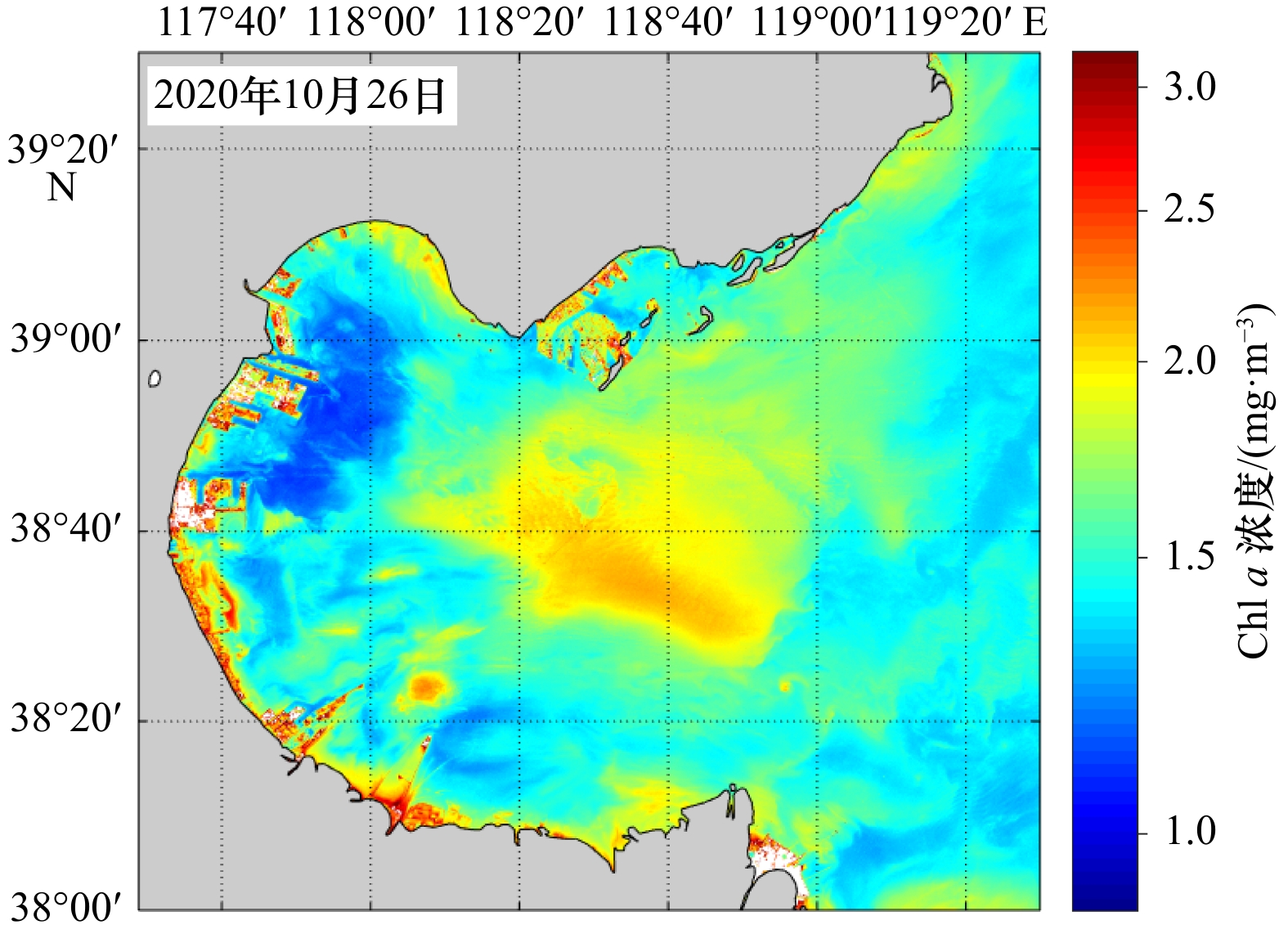
摘要: 叶绿素a作为最重要的水质参数之一,是评价水体富营养化和初级生产力状况的主要因素。我国海洋一号C(HY-1C)卫星海岸带成像仪(CZI)具有高时空分辨率的观测优势。本文基于东海和南海现场实测数据建立了HY-1C卫星CZI叶绿素a浓度反演模型并在实测水域进行反演,与MODIS叶绿素a浓度反演产品进行了对比验证,应用CZI叶绿素a浓度模型在珠江口、长江口、渤海湾水域进行了叶绿素a浓度反演示例试验。结果表明,叶绿素a浓度模型估算浓度与实测浓度相关系数为0.774 3,平均相对误差为24.58%,利用实测叶绿素a浓度对模型进行精度验证,相关系数达到0.993 9,平均相对误差为18.49%。模型在实测水域反演得到的叶绿素a浓度分布与MODIS叶绿素a浓度产品分布大体一致。在珠江口水域反演得到叶绿素a浓度空间分布为由西北向东南逐级递减,峰值出现在珠江口西沿岸。在长江口、渤海湾反演叶绿素a浓度空间分布均符合地理实情。研究表明HY-1C卫星CZI数据可应用于中国近海水色定量化研究。Abstract: As one of the most important water quality parameters, chlorophyll a is an important indicator to evaluate the degree of eutrophication of water bodies and also the main factors of primary productivity state of the oceans. The coastal zone imager (CZI) onboard the Chinese Haiyang-1C (HY-1C) satellite has an advantage observation in high temporal and spatial resolution. In this study, a chlorophyll a concentration retrieval model for CZI onboard the HY-1C satellite is developed from the in-situ measurements in the East China Sea and the South China Sea. The chlorophyll a concentration is retrieved by the model in the measured waters and compared with MODIS chlorophyll a concentration. The chlorophyll a concentration also retrieved in the Zhujiang River Estuary, Changjiang River Estuary and Bohai Bay. The correlation coefficient between the predicted value of the model and the in-situ chlorophyll a concentration is 0.774 3, the average relative error is 24.58%. The accuracy of the model is verified with the in-situ measurements with the correlation coefficient of 0.993 9 and the average relative error of 18.49%. The distribution of chlorophyll a concentration retrieved from CZI is nearly the same as that of MODIS. The chlorophyll a concentration decreases gradually from northwest to southeast and the peak value locates on the west bank of the Zhujiang River Estuary. The inversion of chlorophyll a concentration in Changjiang River Estuary and Bohai Bay accords with the actual situation. The work in this study indicates that HY-1C satellite coastal zone imager data are useful for the monitoring of coastal ocean color in China.
-
表 1 HY-1C 卫星海岸带成像仪的基本参数
Tab. 1 Basic parameters of coastal zone imager onboard HY-1C satellite
太阳同步回归轨道波段/μm 不同波段应用对象 0.42~0.50 叶绿素、污染、冰、浅海地形 0.52~0.60 叶绿素、低浓度泥沙、污染、滩涂 0.61~0.69 中等浓度泥沙、植被、土壤 0.76~0.89 植被、高浓度泥沙、大气校正 注:星下点分辨率为50 m;幅宽≥950 km;太阳同步回归轨道高度:782 km;太阳同步回归轨道地方时:10:30AM±30 min。 表 2 所用遥感数据基本参数
Tab. 2 The basic parameters of remote sensing data used
覆盖区域 序号 载荷/卫星 成像时间 海南岛 1 CZI/HY-1C 2019年9月26日 03:28 2 CZI/HY-1C 2019年9月26日 03:29 珠江口 3 CZI/HY-1C 2020年1月30日 03:28 4 CZI/ HY-1C 2020年2月26日 03:28 5 CZI/ HY-1C 2020年10月11日 03:25 6 CZI/ HY-1C 2020年11月22日 03:24 7 CZI/ HY-1C 2020年12月4日 03:24 长江口 8 CZI/ HY-1C 2020年11月8日 02:48 9 CZI/ HY-1C 2020年11月8日 02:49 渤海湾 10 CZI/ HY-1C 2020年10月26日 03:20 -
[1] Martin S. 海洋遥感导论[M]. 蒋兴伟等译. 北京: 海洋出版社, 2017: 159−217.Martin S. An Introduction to Ocean Remote Sensing[M]. Jiang Xingwei, et al, trans. Beijing: China Ocean Press, 2017: 159−217. [2] 张棋斐, 吴志峰, 解学通. 河口及近岸海域水体叶绿素浓度反演方法综述[J]. 生态科学, 2017, 36(5): 215−222.Zhang Qifei, Wu Zhifeng, Xie Xuetong. Research progress of the inversion algorithm of chlorophyll-a concentration in estuaries and coastal waters[J]. Ecological Science, 2017, 36(5): 215−222. [3] 王玉芳, 杨士斌, 刘得银, 等. 浮游植物叶绿素a含量不同方法测定比较——以白洋淀区域水体为例[J]. 水文, 2014, 34(5): 57−60. doi: 10.3969/j.issn.1000-0852.2014.05.011Wang Yufang, Yang Shibin, Liu Deyin, et al. Comparison of different methods for phytoplankton chlorophyll a concentration measurement: a study case of water in Baiyangdian Area[J]. Journal of China Hydrology, 2014, 34(5): 57−60. doi: 10.3969/j.issn.1000-0852.2014.05.011 [4] 刘良明. 卫星海洋遥感导论[M]. 武汉: 武汉大学出版社, 2005: 120-138.Liu Liangming. An Introduction to Satellite Oceanic Remote Sensing[M]. Wuhan: Wuhan University Press, 2005: 120−138. [5] 叶小敏. 封面“HY-1C卫星”故事[J]. 海洋学报, 2019, 41(11): 163.Ye Xiaomin. Cover story: HY-1C satellite[J]. Haiyang Xuebao, 2019, 41(11): 163. [6] 蒋兴伟, 何贤强, 林明森, 等. 中国海洋卫星遥感应用进展[J]. 海洋学报, 2019, 41(10): 113−124.Jiang Xingwei, He Xianqiang, Lin Mingsen, et al. Progresses on ocean satellite remote sensing application in China[J]. Haiyang Xuebao, 2019, 41(10): 113−124. [7] 蒋兴伟, 叶小敏, 宋清涛, 等. 中国“海洋一号”卫星图像上的冯·卡门大气涡街现象与动力分析[J]. 海洋学报, 2013, 35(3): 96−103.Jiang Xingwei, Ye Xiaomin, Song Qingtao, et al. Phenomenon and dynamical analysis of the atmospheric von Kármán vortex streets on Chinese Haiyang-1 satellite image[J]. Haiyang Xuebao, 2013, 35(3): 96−103. [8] Cui Tingwei, Ding Jing, Jia Fujuan, et al. Out-of-band response for the Coastal Zone Imager (CZI) onboard China’s ocean color satellite HY-1C: effect on the observation just above the sea surface[J]. Sensors, 2018, 18(9): 3067. doi: 10.3390/s18093067 [9] Cai Li’na, Zhou Minrui, Liu Jianqiang, et al. HY-1C observations of the impacts of islands on suspended sediment distribution in Zhoushan coastal waters, China[J]. Remote Sensing, 2020, 12(11): 1766. doi: 10.3390/rs12111766 [10] 梁超, 刘利, 刘建强, 等. 基于HY-1C CZI影像光谱指数重构数据MNF变换的红树林提取[J]. 海洋学报, 2020, 42(4): 104−112.Liang Chao, Liu Li, Liu Jianqiang, et al. Extracting mangrove information using MNF transformation based on HY-1C CZI spectral indices reconstruction data[J]. Haiyang Xuebao, 2020, 42(4): 104−112. [11] 周屈, 刘建强, 王剑茹, 等. 利用HY-1C卫星CZI数据在COVID-19疫情期间武汉知音湖和黄家湖的浊度监测研究[J]. 武汉大学学报·信息科学版, 2020, 45(5): 676−681.Zhou Qu, Liu Jianqiang, Wang Jianru, et al. Water turbidity monitoring of Zhiyin and Huangjia Lakes in Wuhan for COVID-19 epidemic using HY-1C CZI data[J]. Geomatics and Information Science of Wuhan University, 2020, 45(5): 676−681. [12] Ji Hongren, Tian Liqiao, Li Jian, et al. Spatial-spectral fusion of HY-1C COCTS/CZI data for coastal water remote sensing using deep belief network[J]. IEEE Journal of Selected Topics in Applied Earth Observations and Remote Sensing, 2020, 14: 1693−1704. [13] 刘建强, 曾韬, 梁超, 等. 海洋一号C卫星在自然灾害监测中的应用[J]. 卫星应用, 2020(6): 26−34. doi: 10.3969/j.issn.1674-9030.2020.06.008Liu Jianqiang, Zeng Tao, Liang Chao, et al. Application of HY-1C satellite in natural disaster monitoring[J]. Satellite Application, 2020(6): 26−34. doi: 10.3969/j.issn.1674-9030.2020.06.008 [14] 许大志, 曹文熙, 王桂芬. 南海北部水体叶绿素a浓度反演的生物光学模型[J]. 热带海洋学报, 2007, 26(2): 15−21. doi: 10.3969/j.issn.1009-5470.2007.02.003Xu Dazhi, Cao Wenxi, Wang Guifen. A bio-optical model for retrieval of chlorophyll a concentration in northern South China Sea[J]. Journal of Tropical Oceanography, 2007, 26(2): 15−21. doi: 10.3969/j.issn.1009-5470.2007.02.003 [15] 马超飞, 蒋兴伟, 唐军武, 等. HY-1 CCD宽波段水色要素反演算法[J]. 海洋学报, 2005, 27(4): 38−44.Ma Chaofei, Jiang Xingwei, Tang Junwu, et al. Inverse algorithms of ocean constituents for HY-1/CCD broadband data[J]. Haiyang Xuebao, 2005, 27(4): 38−44. [16] 唐军武, 王晓梅, 宋庆君, 等. 黄、东海二类水体水色要素的统计反演模式[J]. 海洋科学进展, 2004, 22(S1): 1−7.Tang Junwu, Wang Xiaomei, Song Qingjun, et al. Statistical inversion models for case Ⅱ water color elements in the Yellow Sea and East China Sea[J]. Advances in Marine Science, 2004, 22(S1): 1−7. [17] 丛丕福, 牛铮, 曲丽梅, 等. 利用海洋卫星HY-1数据反演叶绿素a的浓度[J]. 高技术通讯, 2005, 15(11): 106−110. doi: 10.3321/j.issn:1002-0470.2005.11.021Cong Pifu, Niu Zheng, Qu Limei, et al. Retrieval of chlorophyll a concentration from ocean satellite HY-1[J]. Chinese High Technology Letters, 2005, 15(11): 106−110. doi: 10.3321/j.issn:1002-0470.2005.11.021 [18] 解学通, 吴志峰, 王婧, 等. 结合实测光谱数据的珠江口水质遥感监测[J]. 广州大学学报(自然科学版), 2016, 15(4): 73−78.Xie Xuetong, Wu Zhifeng, Wang Jing, et al. Remote sensing monitoring on water quality of coastal waters in the Pearl River Estuary based on measured spectral data[J]. Journal of Guangzhou University (Natural Science Edition), 2016, 15(4): 73−78. [19] 马金峰, 詹海刚, 陈楚群, 等. 珠江河口混浊高产水域叶绿素a浓度的遥感估算模型[J]. 热带海洋学报, 2009, 28(1): 15−20. doi: 10.3969/j.issn.1009-5470.2009.01.003Ma Jinfeng, Zhan Haigang, Chen Chuqun, et al. Remote sensing retrieval of chlorophyll a in turbid, productive estuaries: a case study of Zhujing River Estuary[J]. Journal of Tropical Oceanography, 2009, 28(1): 15−20. doi: 10.3969/j.issn.1009-5470.2009.01.003 [20] 刘大召, 李卓, 陈仔豪, 等. 基于高分1号遥感数据港珠澳大桥对珠江口海域悬浮泥沙分布的影响[J]. 广东海洋大学学报, 2020, 40(6): 89−95.Liu Dazhao, Li Zhuo, Chen Zihao, et al. Influence of Hong Kong-Zhuhai-Macao bridge on the distribution of suspended sediment in the Pearl River Estuary[J]. Journal of Guangdong Ocean University, 2020, 40(6): 89−95. [21] 方立刚, 陈水森, 李宏丽. 基于叶绿素a浓度的珠江口感潮河段咸潮监测研究[J]. 安徽农业科学, 2010, 38(30): 17213−17215, 17224. doi: 10.3969/j.issn.0517-6611.2010.30.183Fang Ligang, Chen Shuisen, Li Hongli. Study on salinity based on chlorophyll a in saltwater intrusion reach, Pearl River Estuary[J]. Journal of Anhui Agricultural Sciences, 2010, 38(30): 17213−17215, 17224. doi: 10.3969/j.issn.0517-6611.2010.30.183 [22] 李文凯. 河口海域悬浮泥沙时空动态遥感研究——以珠江口为例[D]. 武汉: 华中师范大学, 2017.Li Wenkai. Remote sensing of suspended sediments concentration spatial-tempory dynamics in Estuary Water —a case in the Pearl River Estuary[D]. Wuhan: Central China Normal University, 2017. [23] 刘华健, 黄良民, 谭烨辉, 等. 珠江口浮游植物叶绿素a和初级生产力的季节变化及其影响因素[J]. 热带海洋学报, 2017, 36(1): 81−91.Liu Huajian, Huang Liangmin, Tan Yehui, et al. Seasonal variations of chlorophyll a and primary production and their influencing factors in the Pearl River Estuary[J]. Journal of Tropical Oceanography, 2017, 36(1): 81−91. [24] Hu Chuanmin, Lee Zhongping, Franz B. Chlorophyll a algorithms for oligotrophic oceans: a novel approach based on three-band reflectance difference[J]. Journal of Geophysical Research, 2012, 117(C1): C01011. [25] 赵蒙蒙, 寇杰锋, 杨静, 等. 粤港澳大湾区海岸带生态安全问题与保护建议[J]. 环境保护, 2019, 47(23): 29−34.Zhao Mengmeng, Kou Jiefeng, Yang Jing, et al. Study on the ecological security and protection measures of the coastal zone in Guangdong-Hong Kong-Macao greater bay area[J]. Environmental Protection, 2019, 47(23): 29−34. [26] 洪官林. 长江口及邻近海域叶绿素的光学特性及其遥感应用[D]. 上海: 华东师范大学, 2011.Hong Guanlin. Optical properties of chlorophyll and remote sensing application in Yangtze Estuary and Adjacent Sea[D]. Shanghai: East China Normal University, 2011. [27] 姜德娟, 张华. 渤海叶绿素浓度时空特征分析及其对赤潮的监测[J]. 海洋科学, 2018, 42(5): 23−31. doi: 10.11759/hykx20171215001Jiang Dejuan, Zhang Hua. Analysis of spatial and temporal characteristics of chlorophyll a concentration and red tide monitoring in Bohai Sea[J]. Marine Sciences, 2018, 42(5): 23−31. doi: 10.11759/hykx20171215001 [28] 马翱慧, 刘湘南, 李婷, 等. 南海北部海域叶绿素a浓度时空特征遥感分析[J]. 海洋学报, 2013, 35(3): 98−105.Ma Aohui, Liu Xiangnan, Li Ting, et al. The satellite remotely-sensed analysis of the temporal and spatial variability of chlorophyll a concentration in the northern South China Sea[J]. Haiyang Xuebao, 2013, 35(3): 98−105. -


 下载:
下载:


