Study on sea ice classification of HY-1C satellite coastal zone imager images based on the optimal feature set
-
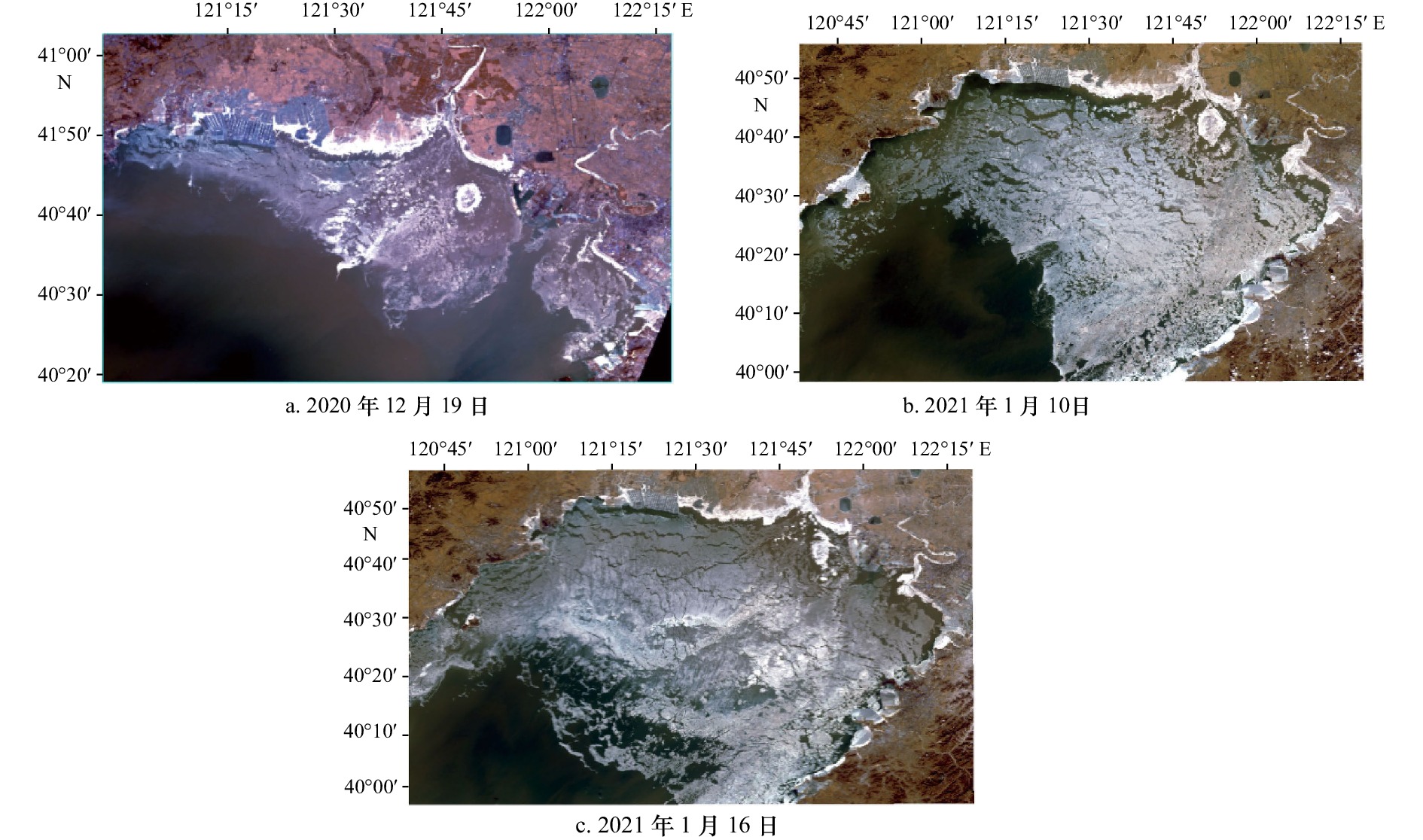
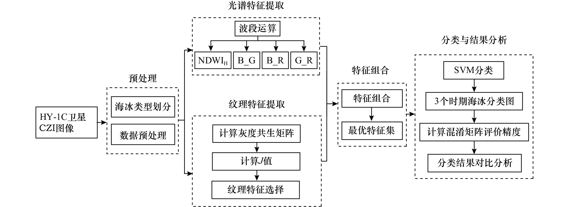
摘要: 基于海洋一号C(HY-1C)卫星海岸带成像仪(CZI)遥感影像,提出了一种基于最优特征集的支持向量机海冰分类方法。分别提取CZI影像的光谱特征和纹理特征,采用基于距离可分性的判据进行特征选择,得到最优特征集,以最优特征集作为支持向量机分类器输入,分别对3期辽东湾海域CZI影像开展海冰分类实验和结果分析。结果表明:本文方法得到的海冰分类结果精度优于仅利用光谱特征或纹理特征的海冰分类精度;基于本文方法的3期影像的海冰分类精度均较高,2020年12月19日、2021年1月10日与2021年1月16日的海冰分类总体精度分别为93.67%、91.75%、84.89%,均在80%以上;利用海冰分类结果图估算海冰面积,发现3期辽东湾海冰面积依次增大,最大约为11 998.98 km2。Abstract: A support vector machine (SVM) sea ice classification method of Haiyang-1C (HY-1C) satellite coastal zone imager (CZI) images based on the optimal feature set is proposed in this paper. The spectral features and the texture features of CZI images are extracted, and then distance separability criterion is used for feature selection to obtain the optimal feature set. The sea ice classification experiment and analysis of the three CZI images of Liaodong Bay are carried out based on SVM classification method with the optimal feature set as the input of the classifier. The results show that the sea ice classification accuracy obtained by the proposed method is better than that of only using the spectral features or the texture features. The sea ice classification accuracy of December 19, 2020, January 10, 2021 and January 16, 2021 are 93.67%, 91.75% and 84.89%, respectively, all above 80%. The sea ice area of Liaodong Bay is estimated according to the sea ice classification map. It is found that the sea ice area of Liaodong Bay in the three images increased successively, and the maximum area is about 11 998.98 km2.
-
表 1 HY-1C卫星海岸带成像仪数据信息表
Tab. 1 Data information of HY-1C satellite coastal zone imager
传感器 波段名称 波长/nm 分辨率/m HY-1C卫星CZI 蓝(波段1) 420~500 50 绿(波段2) 520~600 50 红(波段3) 610~690 50 近红外(波段4) 760~890 50 表 2 海冰类型特征描述
Tab. 2 The description of sea ice type characteristics
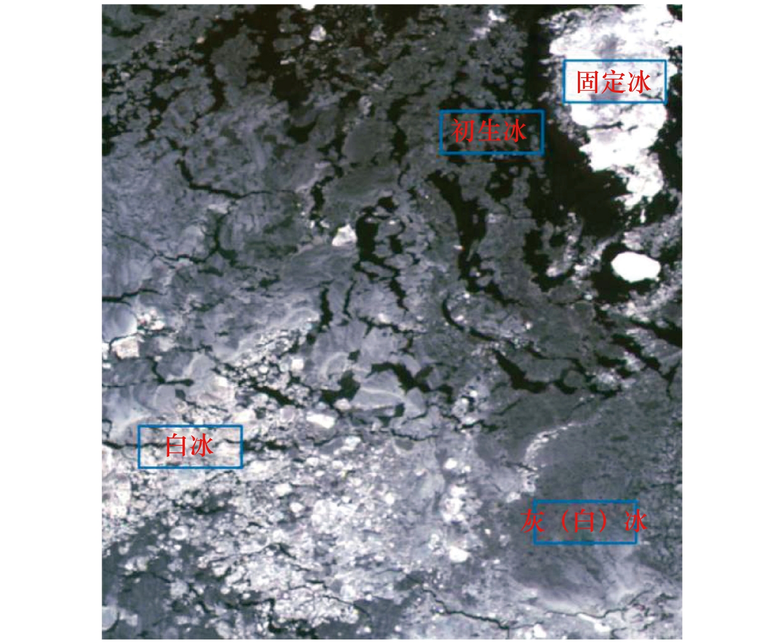
海冰类型 特征描述 固定冰 固定冰是指与海岸、岛屿或海底冻结在一起,不能做水平运动,而能随海面升降做垂直运动的海冰。固定冰的封冻程度和范围对沿岸水产养殖业等有较大影响,固定冰的挤压对岸基和堤坝等建筑可能造成破坏。 白冰 当灰(白)冰厚度继续增加时,冰块颜色由灰白色过渡到白色,表面凹凸不平,形状不规则,成为白冰。厚度大于30 cm。 灰(白)冰 由于灰冰和灰白冰边界模糊,将两类作为一类进行区分。灰冰厚度为 10~15 cm ,灰白冰厚度为15~30 cm,因此,两类合为一类后,灰(白)冰厚度为10~30 cm,灰(白)冰表面比较粗糙,呈灰色或灰白色。 初生冰 当海上气温下降到海水冰点,海水开始结冰形成初生冰,多呈针状、薄片状、浆糊状或绵状。厚度在10 cm以内。 表 3 光谱特征参数定义公式表
Tab. 3 Definition formula of spectral features
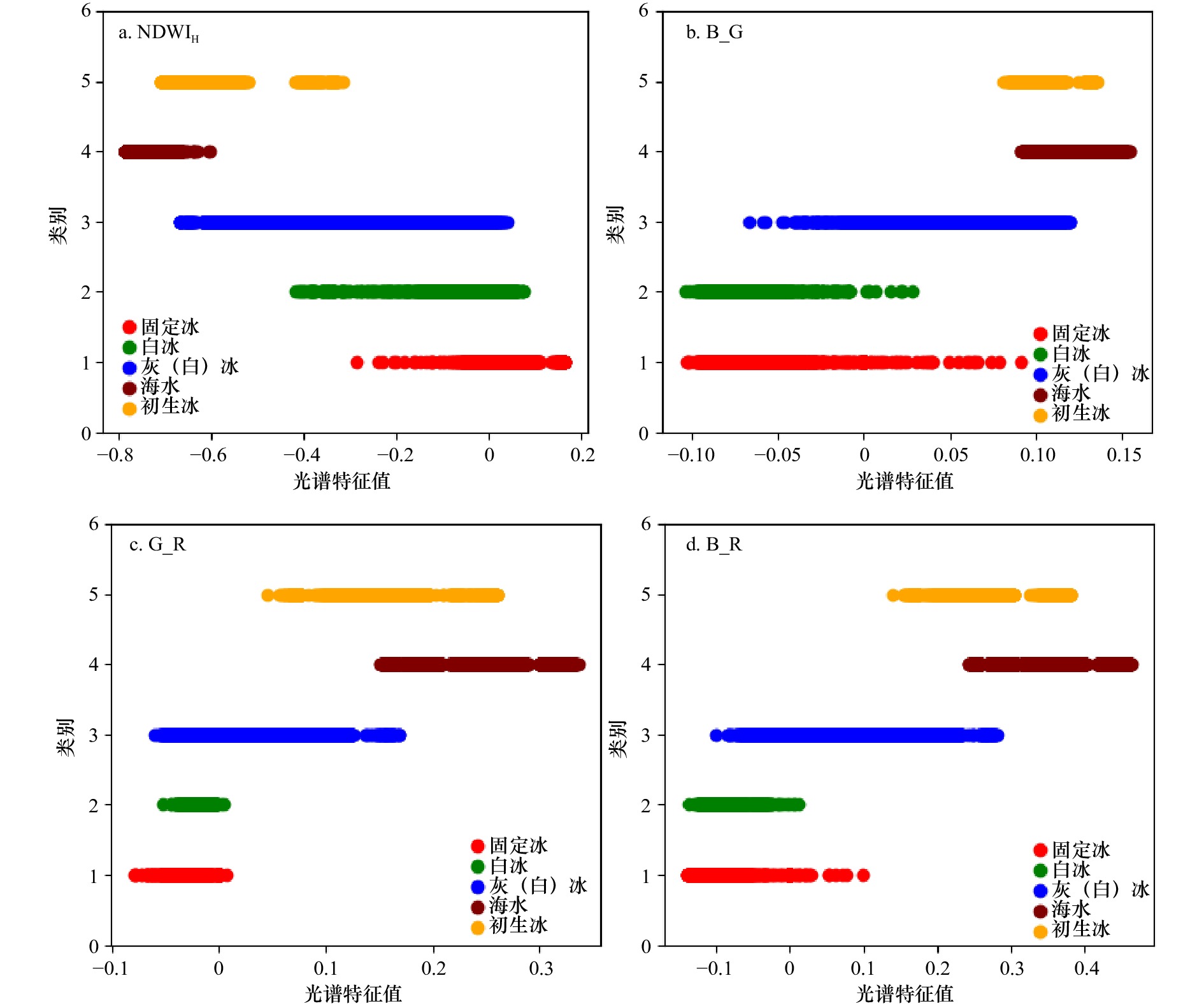
特征标识 定义公式 NDWIH $\rm \left( {NIR - BLUE} \right)/(NIR + BLUE) $ B_G $\rm (BLUE - GREEN)/(BLUE + GREEN) $ B_R $ \rm (BLUE - RED)/(BLUE + RED) $ G_R $\rm (GREEN - RED)/(GREEN + RED) $ 注:BLUE、GREEN、RED、NIR分别表示HY-1C卫星CZI数据的蓝、绿、红、近红外波段。 表 4 各波段纹理特征J值信息表
Tab. 4 The J values of texture features of each band
波段1 波段2 波段3 波段4 均值 5.687 4 3.56 5.234 4 2.27 方差 0.049 2 0.047 5 0.045 9 0.044 9 同质性 2.927 5 2.152 5 2.559 1.66 对比度 0.056 5 0.052 0.051 0.048 相异性 0.807 9 0.776 0.785 4 0.67 熵 4.003 2.354 1 3.293 5 1.69 二阶矩 3.540 8 1.897 6 2.76 1.41 相关性 0.570 3 0.297 1 0.456 2 0.261 5 表 5 2021年1月16日HY-1C卫星CZI影像海冰分类精度评价
Tab. 5 Sea ice classification accuracy evaluation of HY-1C satellite CZI images on January 16, 2021
分类方法 海冰类型 生产者精度/% 用户精度/% 总体精度/% kappa系数 基于光谱特征的SVM海冰分类 固定冰 66.84 39.06 74.58 0.66 白冰 33.05 76.02 灰(白)冰 98.70 74.81 初生冰 69.08 92.62 海水 99.89 99.35 基于纹理特征的SVM海冰分类 固定冰 66.84 35.72 73.41 0.65 白冰 34.87 79.74 灰(白)冰 98.70 73.93 初生冰 69.08 91.37 海水 99 99.35 基于最优特征集的SVM海冰分类 固定冰 85.43 64.44 84.89 0.80 白冰 60.69 85.14 灰(白)冰 96.14 82.14 初生冰 84.22 96.65 海水 99.91 99.40 表 6 2020年12月19日和2021年1月10日HY-1C卫星CZI遥感影像海冰分类精度评价
Tab. 6 Sea ice classification accuracy evaluation of HY-1C satellite CZI images on December 19, 2020 and January 10, 2021
影像获取时间 海冰类型 生产者精度/% 用户精度/% 总体精度/% kappa系数 2020年12月19日 固定冰 93.41 81.28 93.67 0.89 灰(白)冰 89.76 91.94 海水 94.91 99.78 初生冰 92.93 79.35 2021年1月10日 固定冰 70.54 98.59 91.75 0.88 灰(白)冰 99.03 76.31 海水 97.85 99.85 初生冰 96.10 87.43 -
[1] 崔艳荣, 邹斌, 韩震, 等. 卷积神经网络在SAR遥感海冰分类中的应用可行性分析[J]. 海洋预报, 2019, 36(5): 77−85. doi: 10.11737/j.issn.1003-0239.2019.05.010Cui Yanrong, Zou Bin, Han Zhen, et al. Feasibility analysis of convolutional neural networks in remote sensing sea ice classification[J]. Marine Forecasts, 2019, 36(5): 77−85. doi: 10.11737/j.issn.1003-0239.2019.05.010 [2] 刘眉洁, 戴永寿, 张杰, 等. 高分辨率全极化合成孔径雷达数据海冰二次分类方法研究[J]. 海洋学报, 2013, 35(4): 80−87.Liu Meijie, Dai Yongshou, Zhang Jie, et al. The research on the object-based method of sea ice classification of high-resolution quad-polarization SAR data[J]. Haiyang Xuebao, 2013, 35(4): 80−87. [3] 张晰. 极化SAR渤海海冰厚度探测研究[D]. 青岛: 中国海洋大学, 2011.Zhang Xi. Research on sea ice thickness detection by polarimetric SAR in Bohai Sea[D]. Qingdao: Ocean University of China, 2011. [4] Tan Wenxia, LeDrew E. Monitoring Arctic sea ice phenology change using hypertemporal remotely sensed data: 1989–2010[J]. Theoretical and Applied Climatology, 2016, 125(1/2): 353−363. [5] Geldsetzer T, Arkett M, Zagon T, et al. All-season compact-polarimetry C-band SAR observations of sea ice[J]. Canadian Journal of Remote Sensing, 2015, 41(5): 485−504. doi: 10.1080/07038992.2015.1120661 [6] Scheuchl B, Caves R, Cumming I, et al. Automated sea ice classification using spaceborne polarimetric SAR data[C]//IGARSS 2001. Scanning the Present and Resolving the Future. Proceedings. IEEE 2001 International Geoscience and Remote Sensing Symposium. Sydney: IEEE, 2001: 3117−3119. [7] Singha S, Johansson M, Hughes N, et al. Arctic sea ice characterization using spaceborne fully polarimetric L-, C-, and X-Band SAR with validation by airborne measurements[J]. IEEE Transactions on Geoscience and Remote Sensing, 2018, 56(7): 3715−3734. doi: 10.1109/TGRS.2018.2809504 [8] 刘惠颖. 宽幅多极化SAR海冰信息提取方法与类型识别研究[D]. 北京: 中国科学院遥感与数字地球研究所, 2017.Liu Huiying. Study on parameter retrieval and type recognition of sea ice using wide-swath and multi-polarization SAR data[D]. Beijing: Institute of Remote Sensing and Digital Earth, Chinese Academy of Sciences, 2017. [9] 赵泉华, 郭世波, 李晓丽, 等. 利用目标分解特征的全极化SAR海冰分类[J]. 测绘学报, 2018, 47(12): 1609−1620. doi: 10.11947/j.AGCS.2018.20170551Zhao Quanhua, Guo Shibo, Li Xiaoli, et al. Polarimetric SAR sea ice classification based on target decompositional features[J]. Acta Geodaetica et Cartographica Sinica, 2018, 47(12): 1609−1620. doi: 10.11947/j.AGCS.2018.20170551 [10] Riggs G A, Hall D K, Ackerman S A. Sea ice extent and classification mapping with the moderate resolution imaging spectroradiometer airborne simulator[J]. Remote Sensing of Environment, 1999, 68(2): 152−163. doi: 10.1016/S0034-4257(98)00107-2 [11] 史培军, 范一大, 哈斯, 等. 利用AVHRR和MODIS数据测算海冰资源量——以渤海海冰资源测算为例[J]. 自然资源学报, 2002, 17(2): 138−143. doi: 10.3321/j.issn:1000-3037.2002.02.002Shi Peijun, Fan Yida, Ha Si, et al. Calculating gross sea ice resource using AVHRR and MODIS data[J]. Journal of Natural Resources, 2002, 17(2): 138−143. doi: 10.3321/j.issn:1000-3037.2002.02.002 [12] 吴龙涛, 吴辉碇, 孙兰涛, 等. MODIS渤海海冰遥感资料反演[J]. 中国海洋大学学报(自然科学版), 2006, 36(2): 173−179.Wu Longtao, Wu Huiding, Sun Lantao, et al. Retrieval of sea ice in the Bohai Sea from MODIS data[J]. Periodical of Ocean University of China, 2006, 36(2): 173−179. [13] 王姝力, 王志勇, 王磊. 基于Landsat-8和Sentinel-1A辽东湾海冰分类研究[J]. 北京测绘, 2019, 33(12): 1486−1492.Wang Shuli, Wang Zhiyong, Wang Lei. Study of sea ice classification of Landsat-8 and Sentinel-1A in Liaodong Bay[J]. Beijing Surveying and Mapping, 2019, 33(12): 1486−1492. [14] 张晰, 张杰, 孟俊敏. Landsat-8与GF-1卫星渤海海冰探测能力对比研究[J]. 海洋科学, 2015, 39(2): 50−56. doi: 10.11759/hykx20141011018Zhang Xi, Zhang Jie, Meng Junmin. Comparison of sea ice detection ability of Landsat-8 and GF-1 in the Bohai Sea[J]. Marine Sciences, 2015, 39(2): 50−56. doi: 10.11759/hykx20141011018 [15] Barbieux K, Charitsi A, Merminod B. Icy lakes extraction and water-ice classification using Landsat-8 OLI multispectral data[J]. International Journal of Remote Sensing, 2018, 39(11): 3646−3678. doi: 10.1080/01431161.2018.1447165 [16] 王志勇, 王丽华, 刘健, 等. 基于多源中高分辨率遥感数据提取渤海辽东湾海冰要素信息[J]. 自然灾害学报, 2021, 30(1): 174−182.Wang Zhiyong, Wang Lihua, Liu Jian, et al. Extraction of sea ice element information in Liaodong Bay of the Bohai Sea based on multi-source medium and high resolution remote sensing data[J]. Journal of Natural Disasters, 2021, 30(1): 174−182. [17] 刘眉洁. 基于高分辨率极化SAR的海冰分类和厚度探测方法研究[D]. 青岛: 中国石油大学(华东), 2016.Liu Meijie. Research on the sea ice classification and thickness detection with high-resolution and polarimetric SAR data[D]. Qingdao: China University of Petroleum (East China), 2016. [18] 庞海洋, 孔祥生, 孙志伟, 等. 基于遥感和气象数据对辽东湾海冰变化预测研究[J]. 海洋与湖沼, 2018, 49(4): 725−733.Pang Haiyang, Kong Xiangsheng, Sun Zhiwei, et al. The forecast model of sea ice changes in Liaodong Bay using remote sensing and meteorological data[J]. Oceanologia et Limnologia Sinica, 2018, 49(4): 725−733. [19] 罗会兰, 郭敏杰, 孔繁胜. 集成多特征与稀疏编码的图像分类方法[J]. 模式识别与人工智能, 2014, 27(4): 345−355. doi: 10.3969/j.issn.1003-6059.2014.04.009Luo Huilan, Guo Minjie, Kong Fansheng. Image classification method by combining multi-features and sparse coding[J]. Pattern Recognition and Artificial Intelligence, 2014, 27(4): 345−355. doi: 10.3969/j.issn.1003-6059.2014.04.009 [20] Haq M A, Jain K, Menon K P R. Monitoring glacial lakes using remote sensing Tech[C]//Proceedings of the 14th Annual International Conference and Exhibition on Geospatial Information Technology and Applications. Gurgaon: India Geospatial Forum, 2012. [21] 张明, 吕晓琪, 张晓峰, 等. 结合纹理特征的SVM海冰分类方法研究[J]. 海洋学报, 2018, 40(11): 149−156.Zhang Ming, Lü Xiaoqi, Zhang Xiaofeng, et al. Research on SVM sea ice classification based on texture features[J]. Haiyang Xuebao, 2018, 40(11): 149−156. [22] 逯跃锋, 和鑫, 陆黎娟, 等. 基于纹理分析的SAR海冰图像分类方法[J]. 山东理工大学学报(自然科学版), 2019, 33(1): 51−55.Lu Yuefeng, He Xin, Lu Lijuan, et al. Research on classification method of the SAR sea ice image based on texture analysis[J]. Journal of Shandong University of Technology (Natural Science Edition), 2019, 33(1): 51−55. [23] Kiala Z, Mutanga O, Odindi J, et al. Feature selection on Sentinel-2 multispectral imagery for mapping a landscape infested by parthenium weed[J]. Remote Sensing, 2019, 11(16): 1892. doi: 10.3390/rs11161892 [24] 边肇祺, 张学工. 模式识别[M]. 北京: 清华大学出版社, 2004: 9-42.Bian Zhaoqi, Zhang Xuegong. Pattern Recognition[M]. Beijing: Tsinghua University Press, 2004: 9−42. [25] Bogdanov A V, Sandven S, Johannessen O M, et al. Multisensor approach to automated classification of sea ice image data[J]. IEEE Transactions on Geoscience and Remote Sensing, 2005, 43(7): 1648−1664. doi: 10.1109/TGRS.2005.846882 [26] 沈杨. 结合MRF与ν-SVM的SAR海冰图像分类[D]. 合肥: 合肥工业大学, 2015.Shen Yang. Combining MRF and v-SVM for SAR sea ice image classification[D]. Hefei: Hefei University of Technology, 2015. -


 下载:
下载:


