

Coastal wind retrieval from the China-France oceanography satellite scatterometer
-
摘要: 中法海洋卫星散射计(CSCAT)使用扇形波束旋转扫描体制,能够以多角度测量同一海面的雷达后向散射系数,并具有空间分辨率较高的特点。这为近海岸海面风场反演提供了新的机遇。本文介绍了CSCAT近海岸海面风场处理的主要流程和关键技术。特别地,在风场反演之前,利用一种矩形窗算术平均的方法将L1B级的高分辨率条带数据组合平均到相应的风矢量单元中,从而实现近海岸风场反演的快速预处理。通过对比CSCAT、欧洲先进散射计(ASCAT)以及美国QuikSCAT的近海岸风场,发现CSCAT风场的质量在离岸40 km以外区域具有良好的一致性,而在离岸40 km以内显著恶化。分析表明,CSCAT近海岸区域风场统计特征恶化的原因可能是由潜在的海冰污染引起的。总体而言,CSCAT的近海岸风场与模式背景风场和浮标风场都具有良好的一致性。Abstract: The scatterometer onboard China-France oceanography satellite (CFOSAT) uses rotating fan beams to measure sea surface radar backscatter values at different incidence and azimuth angles. The backscatter measurements of CFOSAT scatterometer (CSCAT) are with relatively high spatial resolution. Therefore, it presents unprecedented opportunities for retrieving offshore wind fields. This paper introduces the main procedures as well as the key techniques of the coastal wind retrieval for CSCAT. In particular, a box-window is used to aggregate the high-resolution backscatters (namely slices in the level 1B data) into a certain wind vector cell (WVC) before performing the wind inversion. The coastal winds derived from the advanced scatterometer (ASCAT) and the QuikSCAT scatterometer are then used to verify the results of CSCAT coastal wind retrieval. It shows that the CSCAT winds are of good quality over the sea surface with offshore distance larger than 40 km, but degrades rapidly in quality for WVCs with offshore distance below 40 km. Further analysis indicates that the degraded statistical scores are mainly caused by some outliers that may be contaminated by the sea ice. In general, the CSCAT offshore winds are in good agreement with both the model forecasts and the buoy winds.
-
Key words:
- China-France oceanography satellite /
- scatterometer /
- off-shore /
- wind inversion /
- statistical scores
-
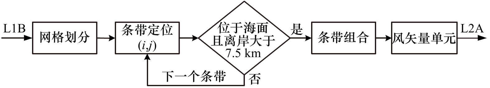
图 1 CFOSAT散射计近海岸风场反演的预处理流程
Fig. 1 Preprocessing flow of the coastal wind retrieval for CFOSAT scatterometer
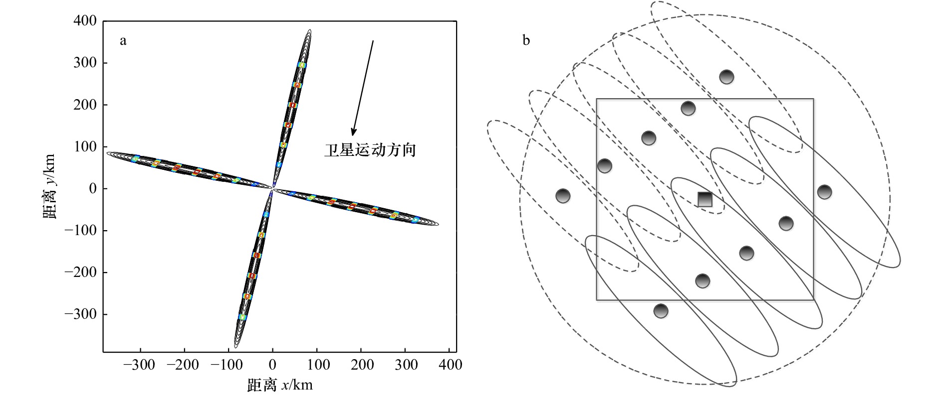
图 2 CFOSAT散射计在4个不同方位角的雷达足迹(黑色等高线),原始分辨单元(条带,彩色等高线)示意图(a)和条带组合示意图(b)
黑色圆点表示条带的中心位置,黑色方块表示网格的中心位置。CFOSAT散射计近海岸风场预处理时,只有中心位置位于网格方框内的条带才被用于组合平均
Fig. 2 The radar footprints (black contours), the raw range-gated resolution (namely slices, color contours) of CFOSAT scatterometer at four different azimuth angles (a) and illustration of the slice aggregation (b)
Black dots represent the slices’ center, and black square indicates the grid center position. Only the slices whose center are inside the square are averaged during the preprocessing flow of CFOSAT coastal wind retrieval

图 3 CFOSAT散射计于2020年5月12日UTC22时41分观测的台风“黄蜂”,网格分辨率为25 km(a);同时间的CFOSAT散射计近海岸海面风场,网格分辨率约为12.5 km(b);ASCAT散射计于5月14日UTC0时50分观测的台风“黄蜂”,网格分辨率为12.5 km的近海岸风场(c)
Fig. 3 CFOSAT scatterometer wind field (Typhoon Vongfong) with 25 km grid resolution. The acquisition date and time are May 12th 2020, at UTC 22:41 (a); the same as a, but for the coastal wind product with resolution of 12.5 km (b); ASCAT coastal wind field (Typhoon Vongfong) with resolution of 12.5 km. The acquisition date and time are May 14th 2020, at UTC 00:50 (c)
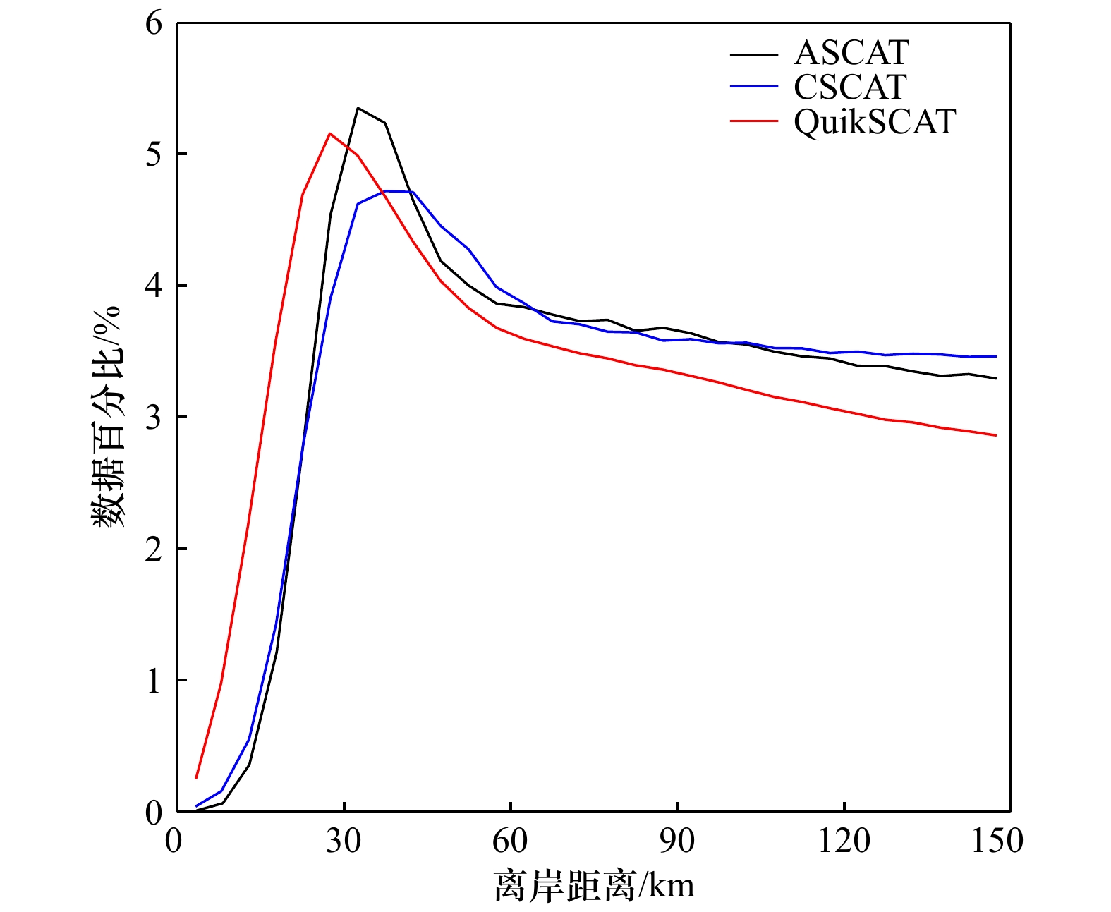
图 4 近海岸区域ASCAT、CFOSAT散射计(CSCAT)以及QuikSCAT散射计观测数据量的分布特征
Fig. 4 The normalized number of wind observations as a function of the distance to coastline for ASCAT, CFOSAT scatterometer (CSCAT), and QuikSCAT, respectively
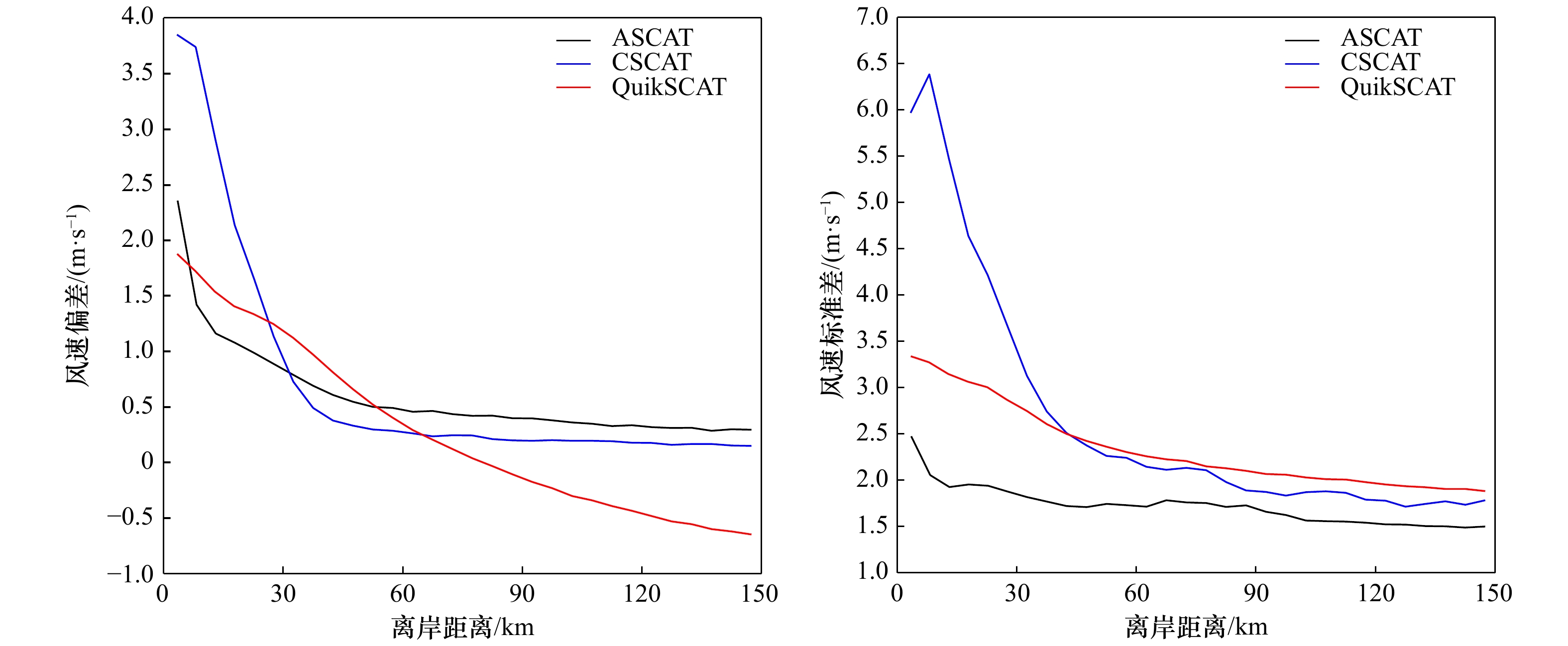
图 5 近海岸区域ASCAT、CFOSAT散射计(CSCAT)以及QuikSCAT散射计的风速偏差(a)和风速标准差(b)统计特征
Fig. 5 The wind speed bias (a) and standard deviation errors (b) as a function of the distance to coastline for ASCAT, CFOSAT scatterometer (CSCAT), and QuikSCAT, respectively

图 6 离岸40 km以内的ASCAT(a),CSCAT(b),以及QuikSCAT(c)海面风场与模式背景风场的对比
CC、Bias、SD分别代表散射计风场与背景风场相关系统,偏差和标准差
Fig. 6 The ASCAT (a), CSCAT(b), and QuikSCAT (c) wind vectors versus model background winds for the observations with distance to coastline < 40 km
CC, Bias, and SD reprenst correlation coefficient, bias and standard deviation, respectiuely
图 7 离岸40 km以内,CSCAT风速偏差(相对于ECMWF)大于6 m/s的异常值的分布直方图
Fig. 7 Geographic histograms of the abnormal CSCAT observations (e.g., wind speed bias larger than 6 m/s with respect to ECMWF) which distance to coastline are less than 40 km
-
[1] Johnson J, Williams L, Bracalente E, et al. Seasat-A satellite scatterometer instrument evaluation[J]. IEEE Journal of Oceanic Engineering, 1980, 5(2): 138−144. doi: 10.1109/JOE.1980.1145461 [2] Tsai W Y, Graf J E, Winn C, et al. Postlaunch sensor verification and calibration of the NASA scatterometer[J]. IEEE Transactions on Geoscience and Remote Sensing, 1999, 37(3): 1517−1542. doi: 10.1109/36.763264 [3] Figa-Saldaña J, Wilson J J W, Attema E, et al. The advanced scatterometer (ASCAT) on the meteorological operational (Metop) platform: A follow on for European wind scatterometers[J]. Canadian Journal of Remote Sensing, 2002, 28(3): 404−412. doi: 10.5589/m02-035 [4] Wang Zhixiong, Zhao Chaofang, Zou Juhong, et al. An improved wind retrieval algorithm for the HY-2A scatterometer[J]. Chinese Journal of Oceanology and Limnology, 2015, 33(5): 1201−1209. doi: 10.1007/s00343-015-4145-3 [5] Bhowmick S A, Kumar R, Kumar A S K. Cross calibration of the OceanSAT-2 scatterometer with QuikSCAT scatterometer using natural terrestrial targets[J]. IEEE Transactions on Geoscience and Remote Sensing, 2014, 52(6): 3393−3398. doi: 10.1109/TGRS.2013.2272738 [6] Long D G, Luke J B, Plant W. Ultra high resolution wind retrieval for SeaWinds[C]// 2003 IEEE International Geoscience and Remote Sensing Symposium. Toulouse: IEEE, 2003: 1264−1266. [7] Fore A, Strub T, James C, et al. Evaluation of coastal scatterometer products[R]. Sapporo: Present at the International Ocean Vector Winds Science Team Meeting, 2016. [8] Verhoef A, Portabella M, Stoffelen A. High-resolution ASCAT scatterometer winds near the coast[J]. IEEE Transactions on Geoscience and Remote Sensing, 2012, 50(7): 2481−2487. doi: 10.1109/TGRS.2011.2175001 [9] Vogelzang J, Stoffelen A. ASCAT ultrahigh-resolution wind products on optimized grids[J]. IEEE Journal of Selected Topics in Applied Earth Observations and Remote Sensing, 2017, 10(5): 2332−2339. doi: 10.1109/JSTARS.2016.2623861 [10] Lin Wenming, Dong Xiaolong, Portabella M, et al. A perspective on the performance of the CFOSAT rotating fan-beam scatterometer[J]. IEEE Transactions on Geoscience and Remote Sensing, 2019, 57(2): 627−639. doi: 10.1109/TGRS.2018.2858852 [11] Liu Jianqiang, Lin Wenming, Dong Xiaolong, et al. First results from the rotating fan beam scatterometer onboard CFOSAT[J]. IEEE Transactions on Geoscience and Remote Sensing, 2020, 58(12): 8793−8806. doi: 10.1109/TGRS.2020.2990708 [12] Stoffelen A, Portabella M. On Bayesian scatterometer wind inversion[J]. IEEE Transactions on Geoscience and Remote Sensing, 2006, 44(6): 1523−1533. doi: 10.1109/TGRS.2005.862502 [13] KNMI Scatterometer Team. NSCAT-4 Geophysical Model Function, 2020[EB/OL]. [2020−09−15]. http://projects.knmi.nl/scatterometer/nscat_gmf/. [14] Vogelzang J, Stoffelen A, Verhoef A, et al. Validation of two-dimensional variational ambiguity removal on SeaWinds scatterometer data[J]. Journal of Atmospheric and Oceanic Technology, 2009, 26(7): 1229−1245. doi: 10.1175/2008JTECHA1232.1 [15] Zhang Kuo, Dong Xiaolong, Zhu Di, et al. Estimation and correction of geolocation errors of the CFOSAT scatterometer using coastline backscatter coefficients[J]. IEEE Journal of Selected Topics in Applied Earth Observations and Remote Sensing, 2020, 14: 53−61. [16] Lin Wenming, Portabella M. Toward an improved wind quality control for RapidScat[J]. IEEE Transactions on Geoscience and Remote Sensing, 2017, 55(7): 3922−3930. doi: 10.1109/TGRS.2017.2683720 [17] Li Zhen, Stoffelen A, Verhoef A. A generalized simulation capability for rotating-beam scatterometers[J]. Atmospheric Measurement Techniques, 2019, 12(7): 3573−3594. doi: 10.5194/amt-12-3573-2019 -

 下载:
下载:
计量
- 文章访问数: 709
- HTML全文浏览量: 226
- PDF下载量: 57
- 被引次数: 0
