

The effects of north wind speed in winter on saltwater intrusion in the Changjiang Estuary
-
摘要: 本文应用三维数值模式ECOM-si,研究冬季不同北风风速对长江河口盐水入侵和青草沙水库取水的影响。数值实验结果表明,北风驱动苏北高盐水向南往长江口输运,在埃克曼输运作用下,长江河口形成北港进南港出水平环流,加剧北港盐水入侵。在枯季平均径流(11 900 m3/s)条件下,当北风风速超过10 m/s,北港口门水通量朝陆净输运,当风速超过11 m/s,北港盐水倒灌至南港。无风时,北港半月平均盐度仅为0.97,北港口门半月平均水位仅为0.13 m;当风速增加到14 m/s时,盐度和水位分别增长到27.4和0.42 m。北风减少了青草沙水库的取水天数。无风时青草沙水库30 d内可取水天数共有29.7 d;当风速高于10 m/s,30 d内可取水天数降为0 d。北风风速增强能够显著增加北港盐水入侵,不利于青草沙水库取水。Abstract: Using the 3-D numerical model Ecom-si, saltwater intrusion in the Changjiang Estuary and water take in the Qingcaosha Reservoir under different wind speeds are studied. Model results show that the high saline water in Subei is transported southward to the Changjiang Estuary. Ekman transport drives a surge along the coast and a horizontal circulation in the Changjiang Estuary, which enters the North Channel (NC) and exit through the South Channel. This process increases salinity in the NC. Under the mean river discharge in the dry season (11 900 m3/s), the net water flux across the mouth of the NC is landward when wind speed exceeds 10 m/s, and the saltwater in the NC can spill over into the South Channel when wind speed exceeds 11 m/s. When wind speed is 0, the 15-day averaged salinity in the NC is only 0.97 and the elevation at the mouth of the NC is only 0.13 m. When wind speed increases to 14 m/s, salinity in the NC increases to 27.4 and the elevation at the mouth of the NC increases to 0.42 m. North wind reduces the number of days that the Qingcaosha Reservoir could take water from Changjiang within a month. When wind speed is 0, the number of days is 29.4 and when wind speed exceeds 10 m/s, the number of days is 0. The salinity in the NC increases with the strength of north wind, which is unfavorable to water take in the Qingcaosha Reservoir.
-
Key words:
- Changjiang Estuary /
- saltwater intrusion /
- north wind /
- salt flux /
- water flux
-

图 1 长江河口形势(a)及崇明东滩气象站观测风玫瑰图(b)
黑色三角形为青草沙水库取水口位置,红点为崇明东滩气象站位置,sec1−sec4为模型计算断面通量的位置。风玫瑰图统计时段为2005−2019年,统计每年的12月、1月和2月
Fig. 1 Topography of the Changjiang River Estuary (a) and wind rose of weather station at the Chongming eastern shoal (b)
The water intake of the Qingcaosha Reservoir is marked by a black triangle, and weather station at the Chongming eastern shoal is marked by a red dot. Cross-sectional fluxes are calculated through sections “sec1”, “sec2”, “sec3” and “sec4”. Wind rose for the winter season (December, January, February) based on the 2005−2019 period at the weather station

图 2 半月(第38 d到第53 d)平均盐度分布
盐度为垂向平均。红点为青草沙水库取水口的位置
Fig. 2 Distribution of 15-day (day 38 to day 53) averaged salinity
The salinity is depth averaged. Red dot indicates the location of water intake of the Qingcaosha Reservoir

图 3 半月(第38 d到第53 d)平均单宽水体输运分布
箭头仅表示方向,颜色表示大小
Fig. 3 Distribution of 15-day (day 38 to day 53) averaged unit water transport
Arrows only indicate direction of transport, color indicate magnitude of transport

图 4 北港口门断面潮差(a)、水通量(b)和盐通量(c)随时间变化
正值为朝海,负值为朝陆。北港口门断面的位置见图1中sec1
Fig. 4 The temporal variation in tidal amplitude (a), water (b) and salt (c) fluxes across the section at the mouth of the North Channel
Positive and negative values indicate seaward and landward, respectively. The location of the section is marked in Fig. 1
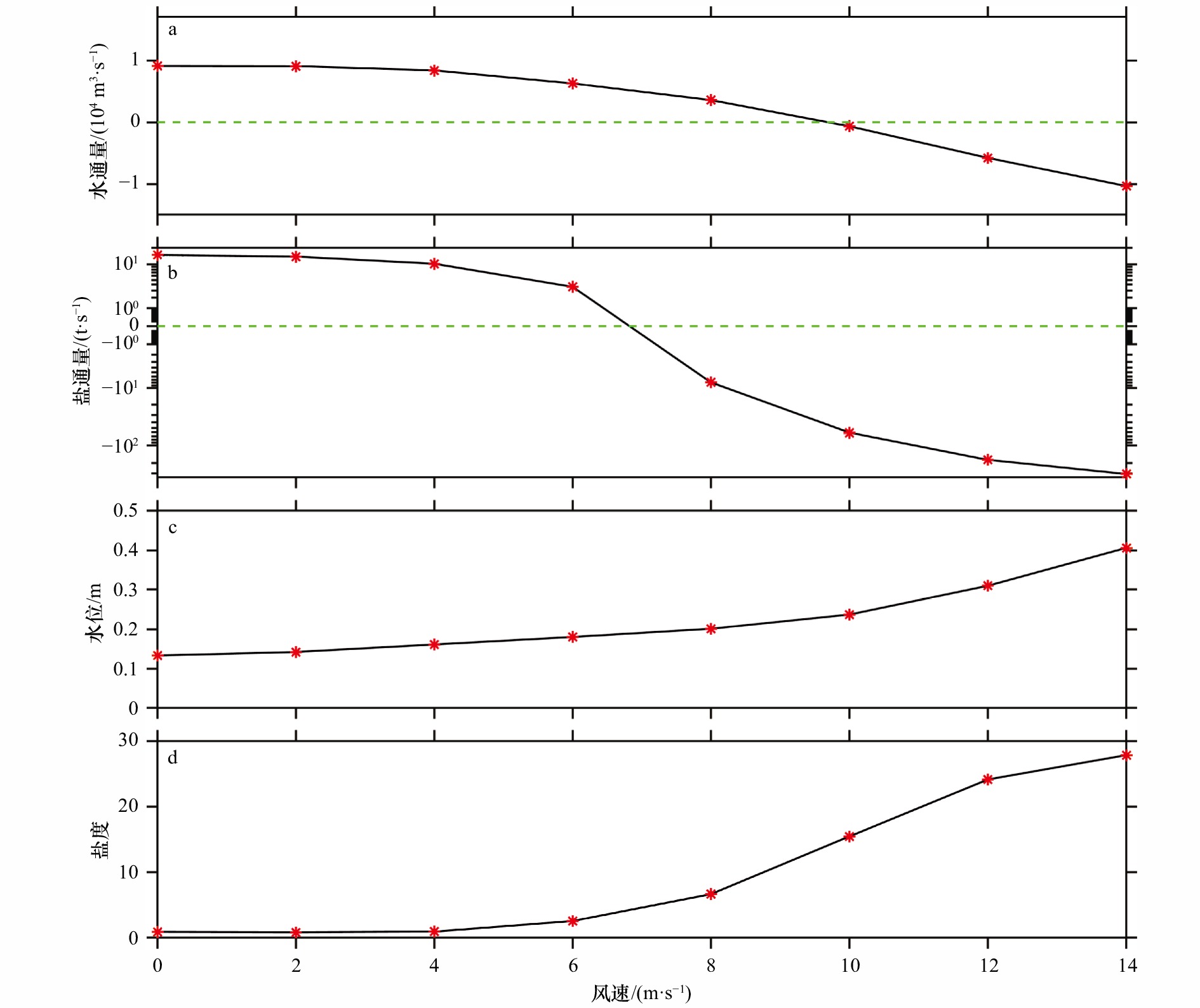
图 5 不同风速作用下北港口门断面半月(第38 d到第53 d)平均水通量(a)、盐通量(b)、水位(c)和整个北港半月平均盐度(d)
正值为朝海,负值为朝陆。北港口门断面的位置见图1中sec1
Fig. 5 Modeled 15-day (day 38 to day 53) averaged water flux (a), salt flux (b), water level (c) across section at the mouth of the North Channel and volume-averaged salinity in the North Channel (d) under various wind speed
Positive and negative values indicate seaward and landward, respectively. The location of the section is marked in Fig. 1
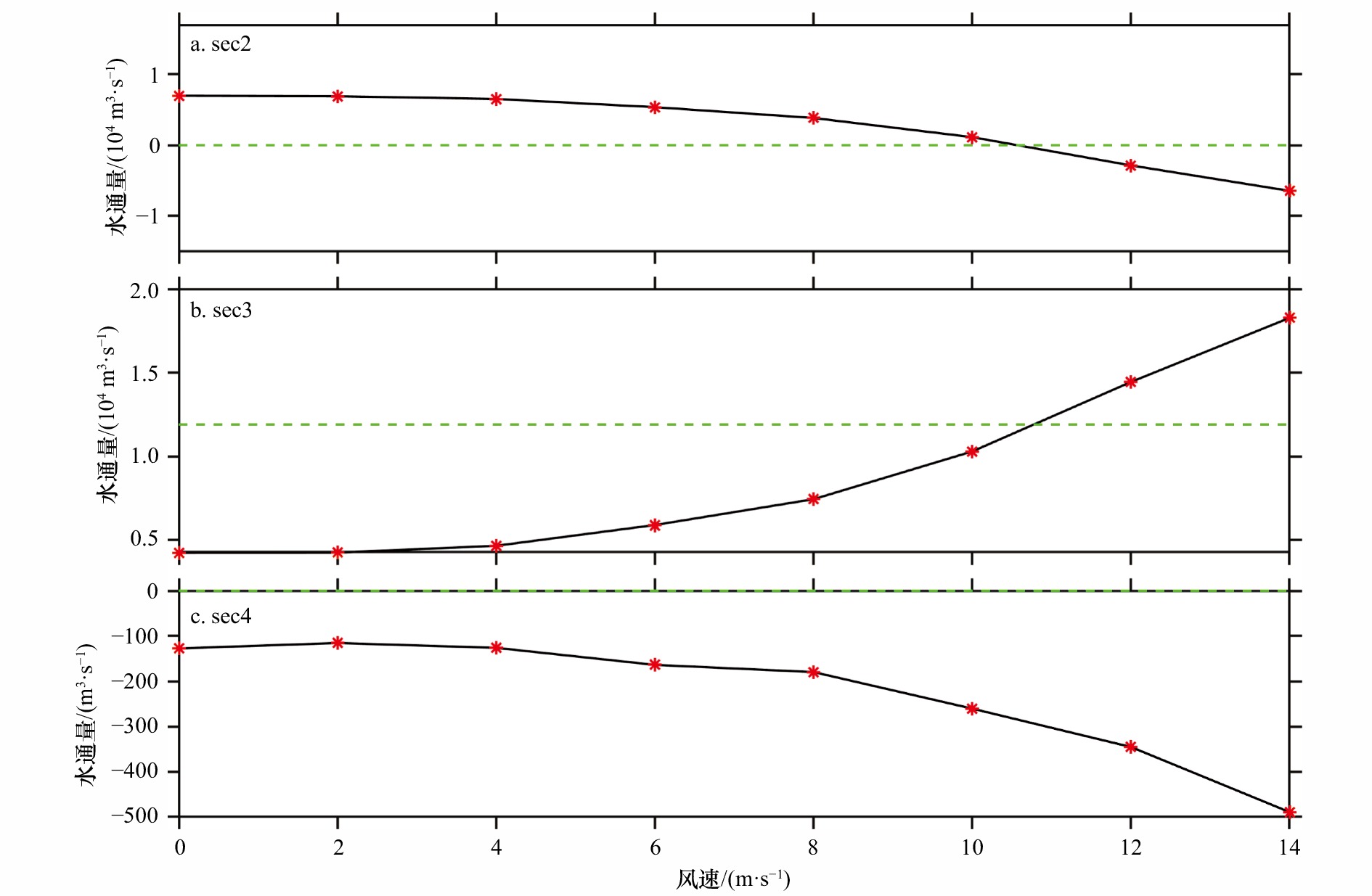
图 6 不同风速条件下断面sec2(a)、sec3(b)和sec4(c)半月(第38 d到第53 d)水通量
中间绿色虚线表示水通量值为11 900 m3/s
Fig. 6 Modeled 15-day (day 38 to day 53) averaged water flux across section at sec2 (a), sec3 (b) and sec4 (c) versus wind speed
The green dashed line in the middle panel indicates the value of 11 900 m3/s
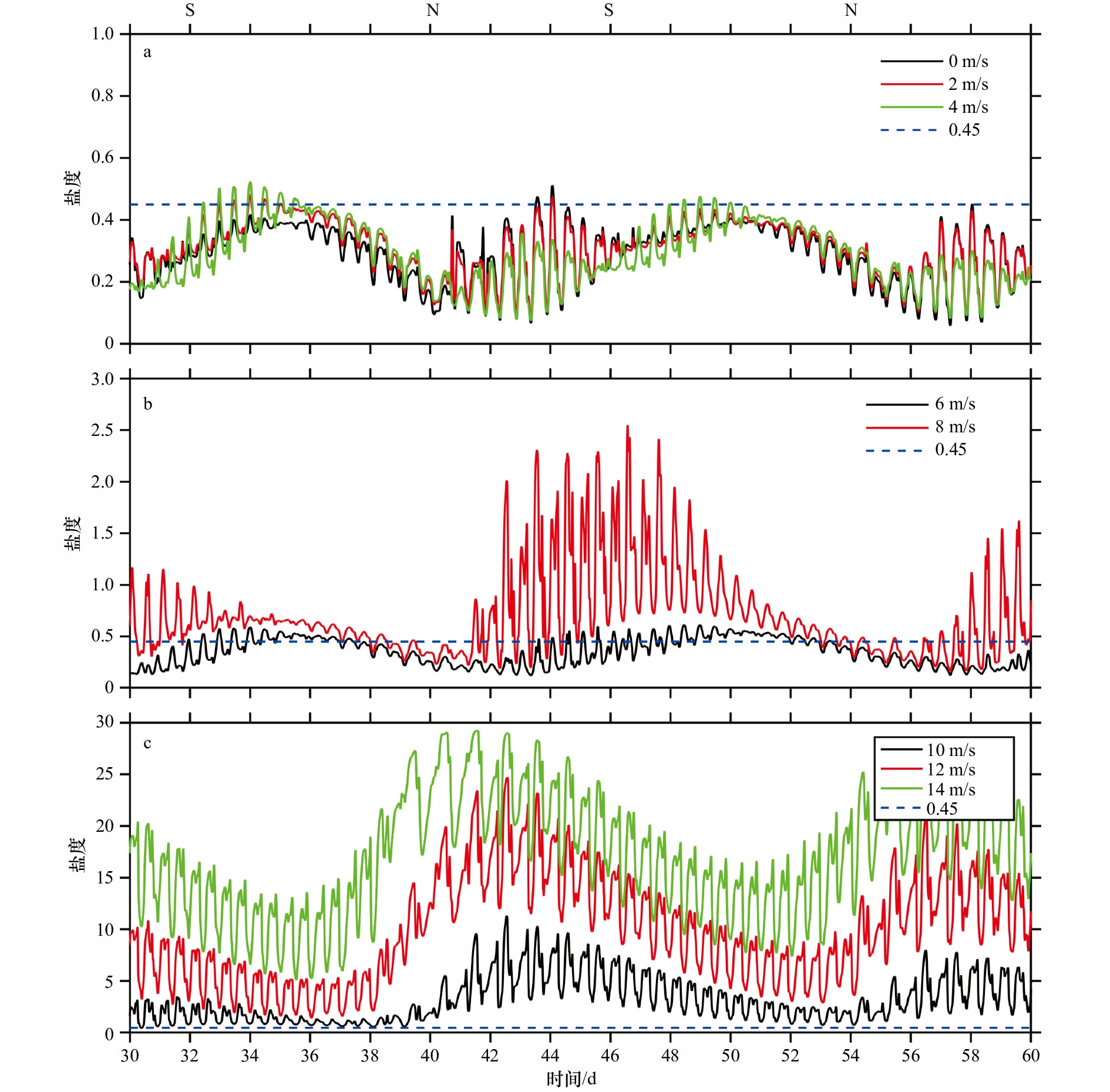
图 7 不同风速作用下青草沙取水口盐度随时间变化
不同颜色实线代表不同风速作用下盐度,蓝色虚线代表盐度0.45。图中最上边S代表北港口门断面潮差最大的时刻,N代表北港口门断面潮差最小的时刻(根据图4a)
Fig. 7 Temporal variation in salinity at the intake of the Qingcaosha Reservoir under different wind speeds
Different color lines indicate results from different wind speeds experiments. Blue dashed line indicates salinity is 0.45. Times of peak spring and neap tides are marked with ‘‘S’’ and ‘‘N’’ (according to Fig. 4a)
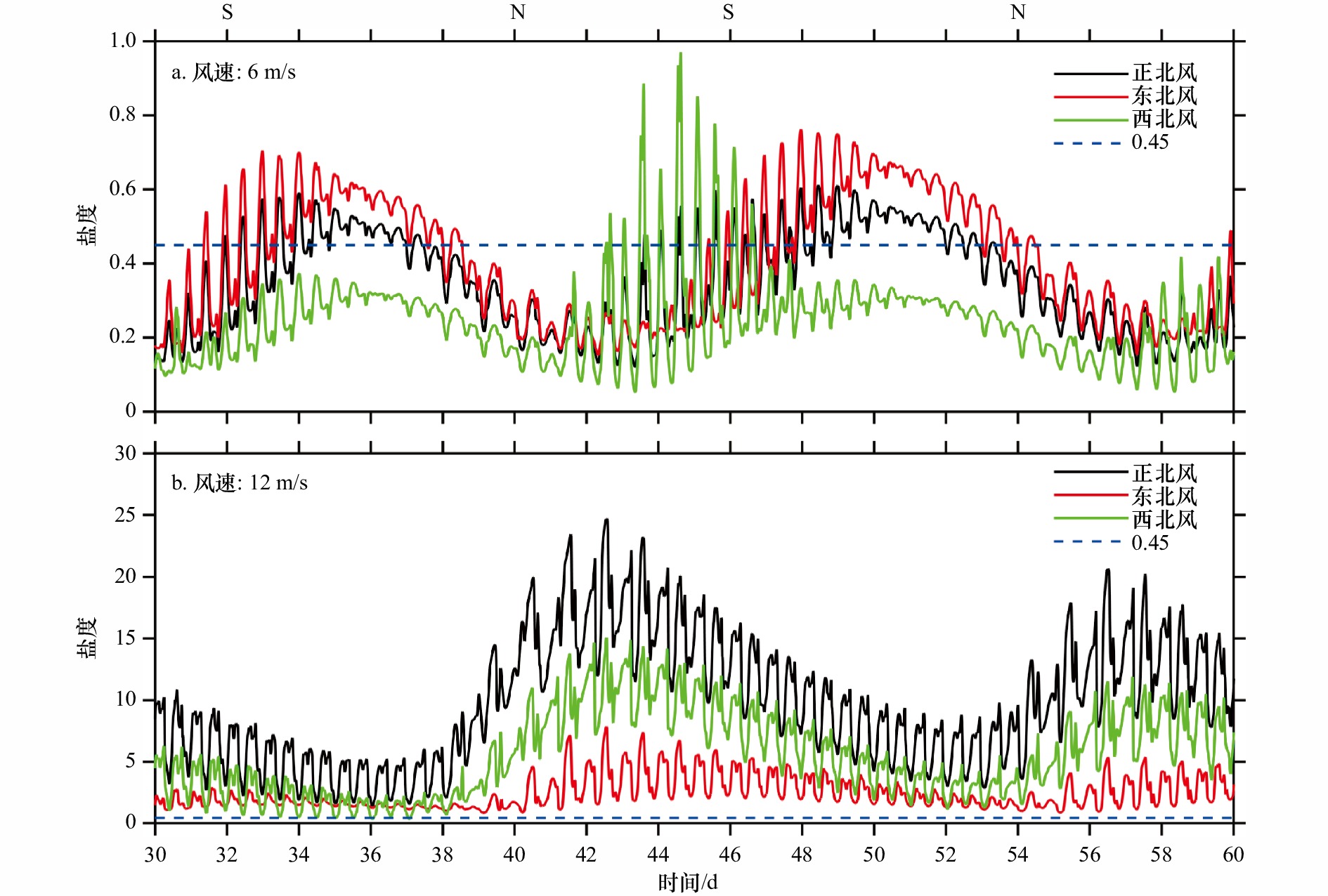
图 8 不同风速和风向作用下青草沙取水口盐度随时间变化
蓝色虚线代表盐度0.45。图中最上边S代表北港口门断面潮差最大的时刻,N代表北港口门断面潮差最小的时刻(根据图4a)
Fig. 8 Temporal variation in salinity at the intake of the Qingcaosha Reservoir under different wind directions and speeds
Blue dashed line indicates salinity is 0.45. Times of peak spring and neap tides are marked with ‘‘S’’ and ‘‘N’’ (according to Fig. 4a)

图 9 不同风向和正北风盐度场差值
左边为小潮后期平均,右边为大潮平均
Fig. 9 Differences in salinity between north wind and other directions
Left panels are averaged during late neap tide, right panels are averaged during spring tide
表 1 30 d内不同风速下最长不宜取水天数和共可取水天数
Tab. 1 The longest continuous days unsuitable and total days suitable for water intakes within 30 days under different wind speeds
天数/d 风速/(m·s−1) 0 2 4 6 8 10 12 14 共可取水天数 29.7 29.5 28.6 20.8 8.9 0 0 0 最长不宜取水天数 0.1 0.1 0.2 3.2 8.0 30 30 30  下载: 导出CSV
-
[1] Qiu Cheng, Zhu Jianrong. Influence of seasonal runoff regulation by the three gorges reservoir on saltwater intrusion in the Changjiang River Estuary[J]. Continental Shelf Research, 2013, 71: 16−26. doi: 10.1016/j.csr.2013.09.024 [2] Bowen M M, Geyer W R. Salt transport and the time-dependent salt balance of a partially stratified estuary[J]. Journal of Geophysical Research: Oceans, 2003, 108(C5): 3158. doi: 10.1029/2001JC001231 [3] Gong Wenping, Shen Jian. The response of salt intrusion to changes in river discharge and tidal mixing during the dry season in the Modaomen Estuary, China[J]. Continental Shelf Research, 2011, 31(7/8): 769−788. [4] Chen S N, Sanford L P. Axial wind effects on stratification and longitudinal salt transport in an idealized, partially mixed estuary[J]. Journal of Physical Oceanography, 2009, 39(8): 1905−1920. doi: 10.1175/2009JPO4016.1 [5] Wang Dongping. Wind-driven circulation in the Chesapeake Bay, winter, 1975[J]. Journal of Physical Oceanography, 1979, 9(3): 564−572. doi: 10.1175/1520-0485(1979)009<0564:WDCITC>2.0.CO;2 [6] Li Chunyan, Weeks E, Rego J L. In situ measurements of saltwater flux through tidal passes of lake pontchartrain estuary by hurricanes gustav and Ike in September 2008[J]. Geophysical Research Letters, 2009, 36(19): L19609. doi: 10.1029/2009GL039802 [7] Chen Qing, Zhu Jianrong, Lyu Hanghang, et al. Determining critical river discharge as a means to provide water supply security to the Changjiang River Estuary, China[J]. Journal of Coastal Research, 2019, 35(5): 1087−1094. doi: 10.2112/JCOASTRES-D-18-00165.1 [8] Wu Hui, Zhu Jianrong, Choi B H. Links between saltwater intrusion and subtidal circulation in the Changjiang Estuary: A model-guided study[J]. Continental Shelf Research, 2010, 30(17): 1891−1905. doi: 10.1016/j.csr.2010.09.001 [9] Qiu Cheng, Zhu Jianrong, Gu Yuliang. Impact of seasonal tide variation on saltwater intrusion in the Changjiang River Estuary[J]. Chinese Journal of Oceanology and Limnology, 2012, 30(2): 342−351. doi: 10.1007/s00343-012-1115-x [10] Li Lu, Zhu Jianrong, Wu Hui, et al. Lateral saltwater intrusion in the north channel of the Changjiang Estuary[J]. Estuaries and Coasts, 2014, 37(1): 36−55. doi: 10.1007/s12237-013-9669-1 [11] Lyu Hanghang, Zhu Jianrong. Impacts of tidal flat reclamation on saltwater intrusion and freshwater resources in the Changjiang Estuary[J]. Journal of Coastal Research, 2019, 35(2): 314−321. doi: 10.2112/JCOASTRES-D-18-00077.1 [12] Li Lu, Zhu Jianrong, Wu Hui. Impacts of wind stress on saltwater intrusion in the Yangtze Estuary[J]. Science China Earth Sciences, 2012, 55(7): 1178−1192. doi: 10.1007/s11430-011-4311-1 [13] Zhang Erfeng, Gao Shu, Savenije H H G, et al. Saline water intrusion in relation to strong winds during winter cold outbreaks: North branch of the Yangtze estuary[J]. Journal of Hydrology, 2019, 574: 1099−1109. doi: 10.1016/j.jhydrol.2019.04.096 [14] Wu Hui, Zhu Jianrong. Advection scheme with 3rd high-order spatial interpolation at the middle temporal level and its application to saltwater intrusion in the Changjiang Estuary[J]. Ocean Modelling, 2010, 33(1/2): 33−51. [15] Lyu Hanghang, Zhu Jianrong. Impact of the bottom drag coefficient on saltwater intrusion in the extremely shallow estuary[J]. Journal of Hydrology, 2018, 557: 838−850. doi: 10.1016/j.jhydrol.2018.01.010 [16] Chen Changsheng, Zhu Jianrong, Ralph E, et al. Prognostic modeling studies of the Keweenaw current in lake superior. Part I: Formation and evolution[J]. Journal of Physical Oceanography, 2001, 31(2): 379−395. doi: 10.1175/1520-0485(2001)031<0379:PMSOTK>2.0.CO;2 [17] 孔亚珍, 贺松林, 丁平兴, 等. 长江口盐度的时空变化特征及其指示意义[J]. 海洋学报, 2004, 26(4): 9−18.Kong Yazhen, He Songlin, Ding Pingxing, et al. Characteristics of temporal and spatial variation of salinity and their indicating significance in the Changjiang Estuary[J]. Haiyang Xuebao, 2004, 26(4): 9−18. [18] Li Xiangyu, Geyer W R, Zhu Jianrong, et al. The transformation of salinity variance: A new approach to quantifying the influence of straining and Mixing on estuarine stratification[J]. Journal of Physical Oceanography, 2018, 48(3): 607−623. doi: 10.1175/JPO-D-17-0189.1 [19] Wu Hui, Gu Jinghua, Zhu Ping. Winter counter-wind transport in the inner southwestern Yellow Sea[J]. Journal of Geophysical Research: Oceans, 2018, 123(1): 411−436. doi: 10.1002/2017JC013403 [20] Li Linjiang, Zhu Jianrong, Chant R J, et al. Effect of dikes on saltwater intrusion under various wind conditions in the Changjiang Estuary[J]. Journal of Geophysical Research: Oceans, 2020, 125(7): e2019JC015685. [21] Lerczak J A, Geyer W R, Chant R J. Mechanisms driving the time-dependent salt flux in a partially stratified estuary[J]. Journal of Physical Oceanography, 2006, 36(12): 2296−2311. doi: 10.1175/JPO2959.1 [22] Li Lu, Zhu Jianrong, Wu Hui, et al. A numerical study on water diversion ratio of the Changjiang (Yangtze) Estuary in dry season[J]. Chinese Journal of Oceanology and Limnology, 2010, 28(3): 700−712. doi: 10.1007/s00343-010-9114-2 [23] 王绍祥, 朱建荣. 不同潮型和风况下青草沙水库取水口盐水入侵来源[J]. 华东师范大学学报(自然科学版), 2015(4): 65−76.Wang Shaoxiang, Zhu Jianrong. Saltwater intrusion sources at the water intake of Qingcaosha Reservoir in different tidal pattern and wind case[J]. Journal of East China Normal University (Natural Science), 2015(4): 65−76. [24] Scully M E, Friedrichs C, Brubaker J. Control of estuarine stratification and mixing by wind-induced straining of the estuarine density field[J]. Estuaries, 2005, 28(3): 321−326. doi: 10.1007/BF02693915 -

计量
- 文章访问数: 503
- HTML全文浏览量: 146
- PDF下载量: 77
- 被引次数: 0
