

Hydrography and circulation of the South China Sea in deep summer: The August 2000 cruises revisited
-
摘要: 在国家重点基础研究发展规划的支持下,2000年8月在南海组织了1次多船同步海洋学调查,是迄今为止盛夏期间唯一一次全海盆准同步水文观测。航次间遭遇的多种困难虽被及时化解,然而观测数据的质量已受影响。此前虽已有若干相关研究发表,但未见对观测数据进行质量控制和全面的分析。本文在对CTD和ADCP原始数据仔细校正的基础上,分析和讨论了盛夏期间南海海盆的水文和环流特征,冀留下尽可能完整的记录。分析表明,盛夏期间以海盆SW−NE向轴线为界,南海展现出不同的物理特征。轴线东南受季节性反气旋环流控制,其中次海盆尺度的南沙反气旋环流尤其强大;轴线西北则受各种中尺度现象支配,未见明显的大尺度环流结构。研究证实南沙反气旋环流的水平尺度超过400 km,垂直尺度达近千米,最大流速近1 m/s, 是夏季南海最突出的环流特征,但发现其位置和强度存在显著的年际变化。研究并发现,不同于以往的认识,观测期间民都洛海峡交换呈“三明治”结构,表明随强迫条件变化,民都洛海峡交换可出现不同模态。Abstract: Funded by the National Key Basic Research Development Program, a multi-vessel oceanography survey was conducted synoptically in the South China Sea (SCS) in August 2000, which appeared to be the unique, available synoptic survey that covered the entire SCS basin in deep summer. A number of difficulties were encountered during the survey that affected the quality of observation, even though they were resolved underway. Although some related research works were previously published, no carefully quality control of the data and a comprehensive analyses had ever appeared before. In this work, the original CTD and shipboard ADCP data were carefully calibrated in the first place, and the hydrography and circulation features were then analyzed and discussed to leave a record of the cruises as complete as possible. The results indicate that, in deep summer, the basin shows different physical characteristics on both sides of its SW–NE oriented axis of the basin. The circulation is generally anticyclonic southeast of the axis, in which the Nansha anticyclonic gyre (NSAG) is especially powerful; the area northwest of the axis, in contrast, appears to be dominated by mesoscale features of different categories, where no obvious structure of large scale circulation is found. The analyses confirm that the scales of the NSAG are over 400 km horizontally and nearly 1000 m vertically, with a maximal swirling speed close to 1 m/s, which appears to be the most remarkable circulation feature of the SCS. Moreover, its position and strength are subject to significant interannual variation. In the Mindoro Strait, the exchange flow showes a sandwich structure during the observation period. This is different from our previous understanding and suggests that the strait exchange may have different modes varying with the forcing condition.
-
Key words:
- South China Sea /
- summer circulation /
- Nansha anticyclonic gyre /
- Mindoro Strait
-

图 1 夏季航次调查
2000年8月南海航次CTD站位(红点)与船载ADCP测线(黄线),18°N南、北分别由“向阳红14”号和“南测12”号调查船执行;红圈标示“向阳红14”号3台CTD的比测站位,①为民都洛海峡
Fig. 1 Map of the summer survey
CTD stations (red dot) and shipboard ADCP tracks (yellow line) of the August 2000 cruises in the South China Sea; the area south and north of 18°N was conducted by R/V Xiang Yang Hong 14 and R/V Nan Ce 12, respectively; red circle marks the inter-calibration stations for the three CTDs onboard R/V Xiang Yang Hong 14, and ① indicates the Mindoro Strait
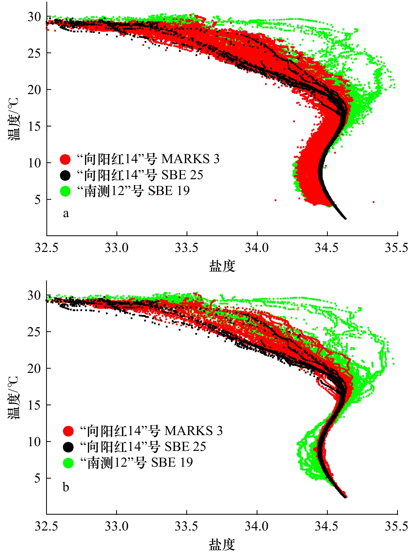
图 2 校正前(a)和校正后(b)所有CTD测站的T-S点聚图
Fig. 2 T-S diagrams for all CTD stations before (a) and after (b) correction

图 3 2000年8月南海的海面重力势异常(DH, 10 J/kg=1 dyn·m)分布(a),卫星高度计遥感海面动力地形(MDT)分布(b),1 000 kPa (深度:100 m)(c)和2 000 kPa(深度:200 m)(d)层的重力势异常分布
重力势异常的参考面为8 000 kPa表面,其中a和b叠加有近表层船载ADCP实测流矢, c叠加有100 m层船载ADCP实测流矢
Fig. 3 Distributions of surface geopotential anomaly (DH, 10 J/kg=1 dyn·m) (a), surface dynamic topography derived (MDT) from satellite altimetry (b), and geopotential anomaly at 1000 kPa (depth: 100 m) (c) and 2 000 kPa levels (depth: 200 m) (d) in the South China Sea in August, 2000
The referred level of geopotential anomaly is the 8 000 kPa surface, subfigure a and b are overlapped with near-surface shipboard ADCP vectors, and so for subfigure c with vectors at 100 m

4 表层、1 000 kPa、2 000 kPa、3 000 kPa、4 000 kPa和5 000 kPa各层的温度(℃,左列)、盐度(中间列)和密度(kg/m3,右列)的水平分布
4 Distributions of temperature (℃, left column), salinity (middle column), and density (kg/m3, right column) at surface, 1000 kPa, 2000 kPa, 3 000 kPa, 4 000 kPa and 5 000 kPa levels
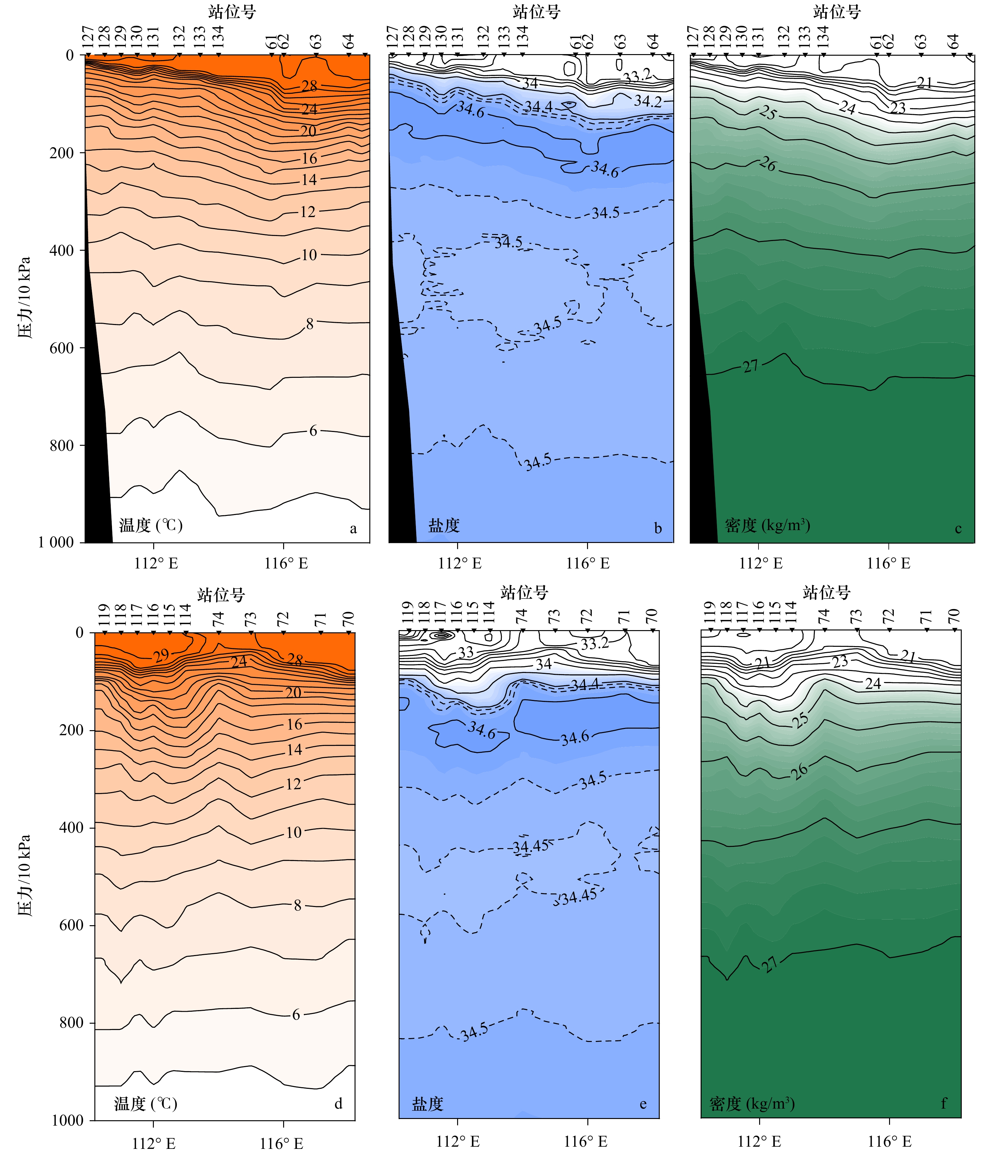
图 5 15°N(a−c)和12°N(d−f)两个纬向跨海盆断面上水文性质的垂直分布
Fig. 5 Vertical distributions of hydrographic properties on zonal, cross-basin sections in 15°N(a−c)and 12°N(d−f)

图 6 各次观测期间(a−d)和相应气候态的月平均(e−h)卫星高度计遥感海面动力地形(单位:m)
Fig. 6 Monthly surface dynamic topography (unit: m) derived from satellite altimetry for each observational period (a−d) and the corresponding climatological month (e−h)

图 7 民都洛海峡口外100 m层的密度分布(单位:kg/m3)、CTD测站(灰点)、船载ADCP测线(红线)(a);船载ADCP测线平均流速剖面,粉色(蓝色)为SE(NE)分量 (b);a图中CTD测站温度(红线)和盐度(蓝线)的深度剖面,粗线为WOA13之1°平均值(9.5°N,120.5°E)(c)
Fig. 7 Distribution of density on the 100 m level off the Mindoro Strait plotted with CTD stations (grey dots) and shipboard ADCP tracks used (red line) (a); vertical profiles of SW (pink) and NE (blue) current components averaged along the ADCP tracks (b); vertical profiles of temperature (red) and salinity (blue) of CTD stations in subfigure a, and for the one degree mean at (9.5°N,120.5°E) from WOA13 (thick lines) (c)
-
[1] Liu Yonggang, Yuan Yaochu, Su Jilan, et al. Circulation in the South China Sea in summer of 1998[J]. Chinese Science Bulletin, 2000, 45(18): 1648−1655. doi: 10.1007/BF02898979 [2] 许金电, 李立, 郭小钢, 等. 1998年夏季季风爆发前后南海环流的多涡特征[J]. 热带海洋学报, 2001, 20(1): 44−51.Xu Jindian, Li Li, Guo Xiaogang, et al. Multi-eddy features of South China Sea circulation around onset of summer monsoon in 1998[J]. Journal of Tropical Oceanography, 2001, 20(1): 44−51. [3] 吴日升, 郭小钢, 李立. 1998年冬季南海的海洋水文特征与环流[J]. 海洋学报, 2002, 24(S1): 142−153.Wu Risheng, Guo Xiaogang, Li Li. Winter hydrographic condition and circulation of the South China Sea in 1998[J]. Acta Oceanologica Sinica, 2002, 24(S1): 142−153. [4] 许金电, 李立, 郭小刚. 2000年夏季南海“向阳红14”号航次CTD数据处理和校正技术报告[R]. 厦门: 国家海洋局第三海洋研究所, 2001.Xu Jindian, Li Li, Guo Xiaogang. CTD data processing and correction for the 2000 summer cruise of R/V Xiangyanghong 14[R]. Xiamen: Third Institute of Oceanography, State Oceanic Administration, 2001. [5] 袁耀初, 刘勇刚, 楼如云, 等. 2000年夏季南海环流的改进逆方法计算[J]. 海洋学报, 2004, 26(1): 1−13.Yuan Yaochu, Liu Yonggang, Lou Ruyun, et al. Calculation of circulation in the South China Sea during the summer of 2000 by the modified inverse method[J]. Acta Oceanologica Sinica, 2004, 26(1): 1−13. [6] Wang Huiqun, Yuan Yaochu, Guan Weibing, et al. Circulation in the South China Sea during summer 2000 as obtained from observations and a generalized topography-following ocean model[J]. Journal of Geophysical Research: Atmospheres, 2004, 109(C7): C07007. [7] Xiao Xianjun, Wang Dongxiao, Xu Jianjun. The assimilation experiment in the southwestern South China Sea in summer 2000[J]. Chinese Science Bulletin, 2006, 51(S2): 31−37. doi: 10.1007/s11434-006-9031-4 [8] Li Li, Wu Risheng. Comment on “Circulation in the South China Sea during summer 2000 as obtained from observations and a generalized topography-following ocean model” by H. Wang et al[J]. Journal of Geophysical Research: Oceans, 2006, 111(C3): C03007. [9] Wang Huiqun, Yuan Yaochu, Guan Weibing, et al. Reply to comment by L. Li and R. Wu on “Circulation in the South China Sea during summer 2000 as obtained from observations and a generalized topography-following ocean model”[J]. Journal of Geophysical Research: Atmospheres, 2006, 111(C3): C03008. [10] 庄伟, 王东晓, 吴日升, 等. 2000年夏季福建、广东沿海上升流的遥感与船舶观测分析[J]. 大气科学, 2005, 29(3): 438−444.Zhuang Wei, Wang Dongxiao, Wu Risheng, et al. Coastal upwelling off eastern Fujian-Guangdong detected by remote sensing[J]. Chinese Journal of Atmospheric Sciences, 2005, 29(3): 438−444. [11] Gan Jianping, Cheung A, Guo Xiaogang, et al. Intensified upwelling over a widened shelf in the northeastern South China Sea[J]. Journal of Geophysical Research: Oceans, 2009, 114(C9): C09019. [12] Yuan Yaochu, Zhao Jinping, Wang Huiqun, et al. Current measurements and spectral analyses in the upper 450 m and deep layers of the northeastern South China Sea[J]. Science in China Series D: Earth Sciences, 2002, 45(11): 1008−1026. doi: 10.1007/BF02911239 [13] Joyce T M. On in situ “calibration” of shipboard ADCPs[J]. Journal of Atmospheric and Oceanic Technology, 1989, 6(1): 169−172. doi: 10.1175/1520-0426(1989)006<0169:OISOSA>2.0.CO;2 [14] Li Li. Summer upwelling system over the northern continental shelf of the South China Sea—a physical description[C]//Proceedings of the Symposium on the Physical and Chemical Oceanography of the China Seas. Beijing: China Ocean Press, 1993: 58–68. [15] Gan Jianping, Li Li, Wang Dongxiao, et al. Interaction of a river plume with coastal upwelling in the northeastern South China Sea[J]. Continental Shelf Research, 2009, 29(4): 728−740. doi: 10.1016/j.csr.2008.12.002 [16] Liu Qinyu, Yang Haijun, Liu Zhengyu. Seasonal features of the Sverdrup circulation in the South China Sea[J]. Progress in Natural Science, 2001, 11(3): 202−206. [17] Wyrtki K. Physical oceanography of the Southeast Asian waters[C]//NAGA Report Volume 2, Scientific Results of Marine Investigations of the South China Sea and the Gulf of Thailand. La Jolla California: Scripps Institution of Oceanography, 1961. [18] 徐锡祯, 邱章, 陈惠昌. 南海水平环流的概述[C]//中国海洋湖沼学会水文气象学会学术会议(1980)论文集. 北京: 科学出版社, 1982: 137-145.Xu Xizhen, Qiu Zhang, Chen Huichang. The general descriptions of the horizontal circulation in the South China Sea[C]//Proceedings of the 1980 Symposium on Hydrometeorology of the Chinese Society of Oceanology and Limnology. Beijing: Science Press, 1982: 137–145. [19] Fang Wendong, Guo Zhongxin, Huang Yuting. Observational study of the circulation in the southern South China Sea[J]. Chinese Science Bulletin, 1998, 43(11): 898−905. doi: 10.1007/BF02884607 [20] Fang Wendong, Fang Guohong, Shi Ping, et al. Seasonal structures of upper layer circulation in the southern South China Sea from in situ observations[J]. Journal of Geophysical Research: Oceans, 2002, 107(C11): 3202. doi: 10.1029/2002JC001343 [21] Qu Tangdong, Song Y T, Yamagata T. An introduction to the South China Sea throughflow: its dynamics, variability, and application for climate[J]. Dynamics of Atmospheres and Oceans, 2009, 47(1/3): 3−14. [22] Qu Tangdong, Song Y T. Mindoro Strait and Sibutu Passage transports estimated from satellite data[J]. Geophysical Research Letters, 2009, 36(9): L09601. [23] Sprintall J, Gordon A L, Flament P, et al. Observations of exchange between the South China Sea and the Sulu Sea[J]. Journal of Geophysical Research: Oceans, 2012, 117(C5): C05036. -

 下载:
下载:

计量
- 文章访问数: 499
- HTML全文浏览量: 133
- PDF下载量: 58
- 被引次数: 0
