

Experiment of assimilating Doppler radar data in Typhoon Saomai based on the different initial conditions
-
摘要: 本文针对2006年登陆我国的超强台风“桑美”,分别采用美国国家环境预报中心的全球预报系统(Global Forecasting System, GFS)再分析资料和日本气象厅(Japan Meteorological Agency, JMA)区域客观再分析资料作为背景场,利用中尺度数值模式WRF(Weather Research and Forecasting Model)及其三维变分同化系统进行多普勒雷达资料同化和数值模拟试验,考察不同的背景场条件下雷达资料同化对台风初始场、内部结构及其随后确定性预报的影响。结果表明:GFS试验和JMA试验在同化了雷达资料之后分析出的台风700 hPa风场和500 hPa高度场相比其初始场均有所增强,JMA试验在3 h同化窗内的均方根误差和最小海平面气压的改进效果均比GFS试验显著,同时对台风动力和热力结构的改进效果也优于GFS试验;JMA试验对台风降水、路径、强度的预报均优于GFS试验,且能预报出台风前沿的降水,更加接近观测实况。Abstract: Based on the WRF (Weather Research and Forecasting Model) and its three-dimensional variational data assimilation system, the numerical simulation and Doppler radar data assimilation are conducted with the data of GFS (Global Forecasting System) and JMA (Japan Meteorological Agency) reanalyses as the initial conditions respectively. The impact of assimilation radar data in different background fields on the initial typhoon field, internal structure and forecast were investigated based on the super typhoon case Saomai in 2006. The results show that, both experiments with GFS and JMA data are able to enhance the typhoon initial winds field at 700 hPa and geopotential height field at 500 hPa after assimilating radar observations. The improvements in terms of the root-mean-square error during the 3 h during the data assimilation cycling, the minimum sea level pressure, and the thermal and dynamic structure from the JMA tests are more significant than that with GFS data. The forecast skills for the precipitation, the typhoon track, and the intensity are also noticeable with JMA data by correctly predicting the precipitation location in the front of typhoon.
-
Key words:
- initial conditions /
- data assimilation /
- WRF model /
- radar radial velocity
-
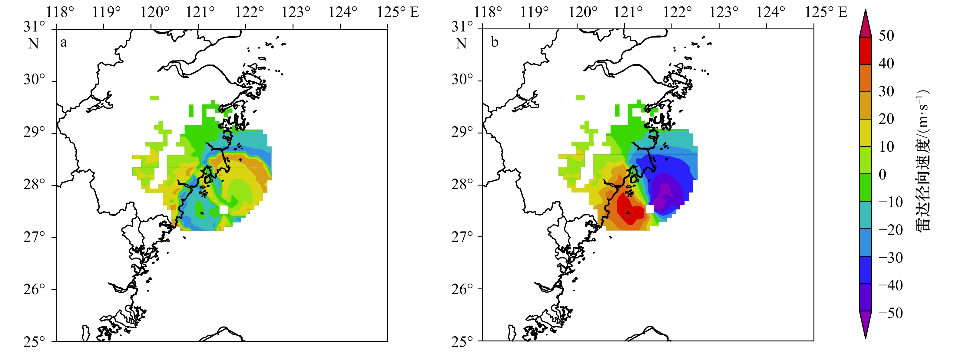
图 1 质量控制前(a)和质量控制后(b)雷达径向速度对比
Fig. 1 Comparison of radar velocity before (a) and after (b) quality control
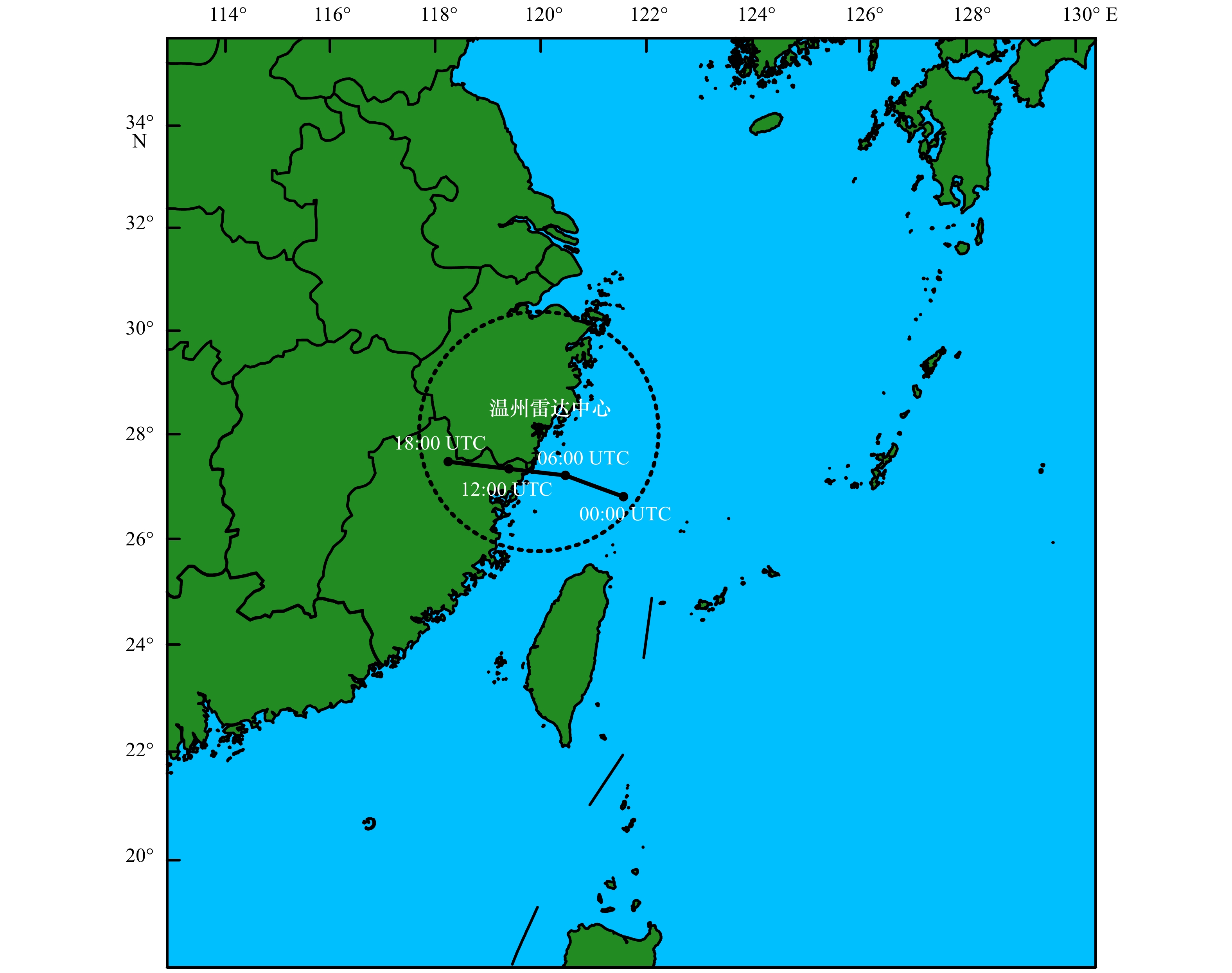
图 2 WRF模拟区域范围
2006年8月10日00:00 UTC至18:00 UTC台风“桑美”观测最佳路径和温州雷达中心位置及其雷达径向风对应影响半径
Fig. 2 WRF simulation area
The best track positions for Typhoon Saomai from China Meteorological Administration from 00:00 to 18:00 UTC on August 10, 2006. Also indicated the Wenzhou radar location and maximum range coverage circles

图 4 2006年8月10日03:00 UTC GFS试验(a)和JMA试验(b)700 hPa风场增量(阴影区域为观测雷达资料覆盖区域)
Fig. 4 The analysis wind increment of 700 hPa for GFS (a) and JMA (b) experiments at 03:00 UTC on August 10, 2006 (the shaded is the radar observation data coverage area)

图 5 同化雷达径向风资料前GFS试验(a)、JMA试验(b)和同化雷达径向风资料后GFS试验(c)、JMA试验(d)500 hPa高度场(等值线,单位:m)
Fig. 5 The 500 hPa geopotential height filed analysis for GFS (a) and JMA (b) experiments before assimilating radar data, and the analysis for GFS (c) and JMA (d) after assimilating data (contour line, unit: m)

图 6 2006年8月10日03:00 UTC至06:00 UTC每个同化时刻的同化前后径向速度均方根误差(a)和最小海平面气压(b)
Fig. 6 The forecast and analysis (sawtooth pattern during the data assimilation cycling) for root mean square error of radial velocity (a) and the minimum sea level pressures (b) for GFS and JMA experiments from 03:00 UTC to 06:00 UTC on August 10, 2006

图 7 2006年8月10日06:00 UTC GFS试验(a)和JMA试验(b)近地面风场和海平面气压场(等值线,单位:hPa)合成示意图
Fig. 7 The sea level pressure (solid contours, unit: hPa) and the surface wind vectors for GFS (a) and JMA (b) experiments at 06:00 UTC on August 10, 2006
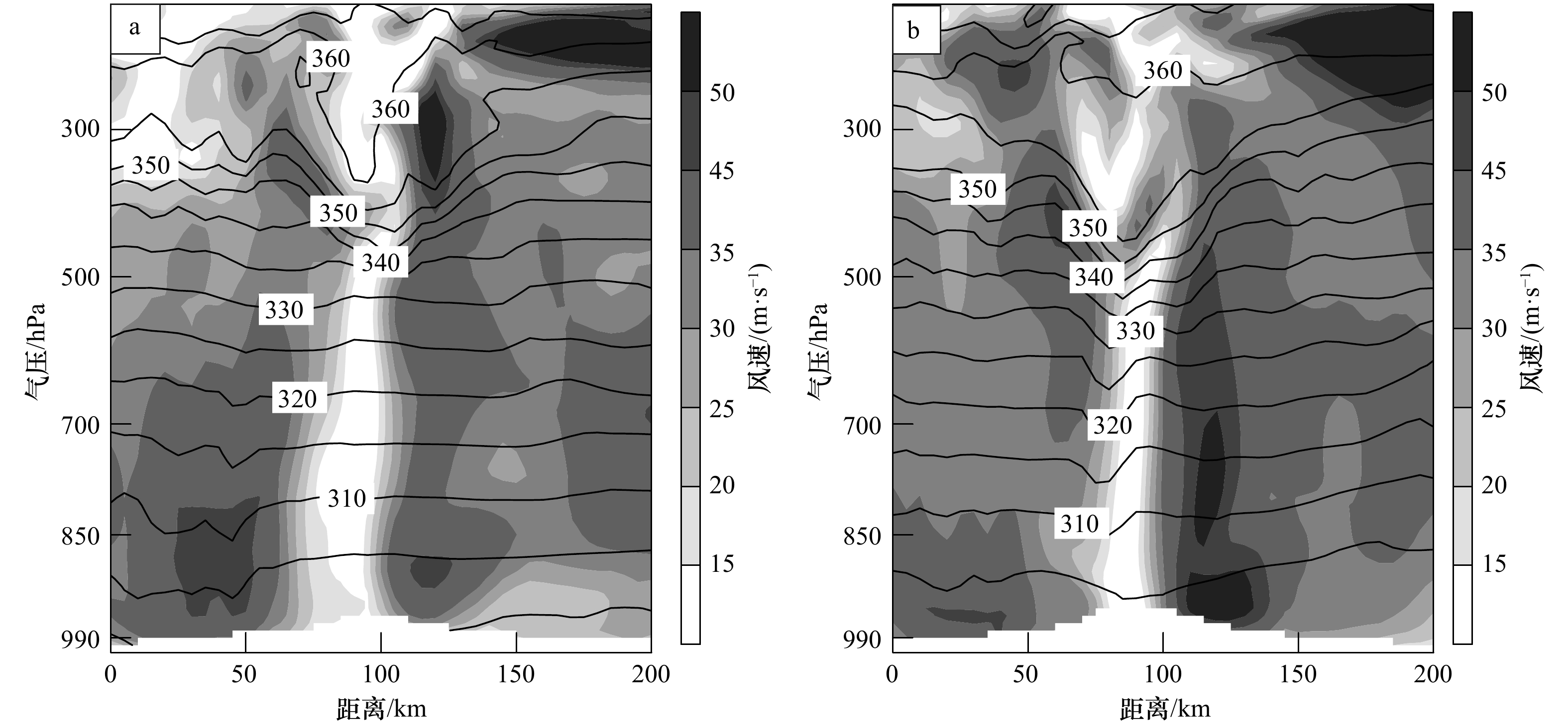
图 8 2006年8月10日06:00 UTC GFS试验(a)和JMA试验(b)经过台风中心风速和位温(等值线,单位:K)的垂直剖面
Fig. 8 Vertical cross sections of analyzed horizontal wind speed and potential temperature (contour line, unit: K) for GFS (a) and JMA (b) experiments at 06:00 UTC on August 10, 2006
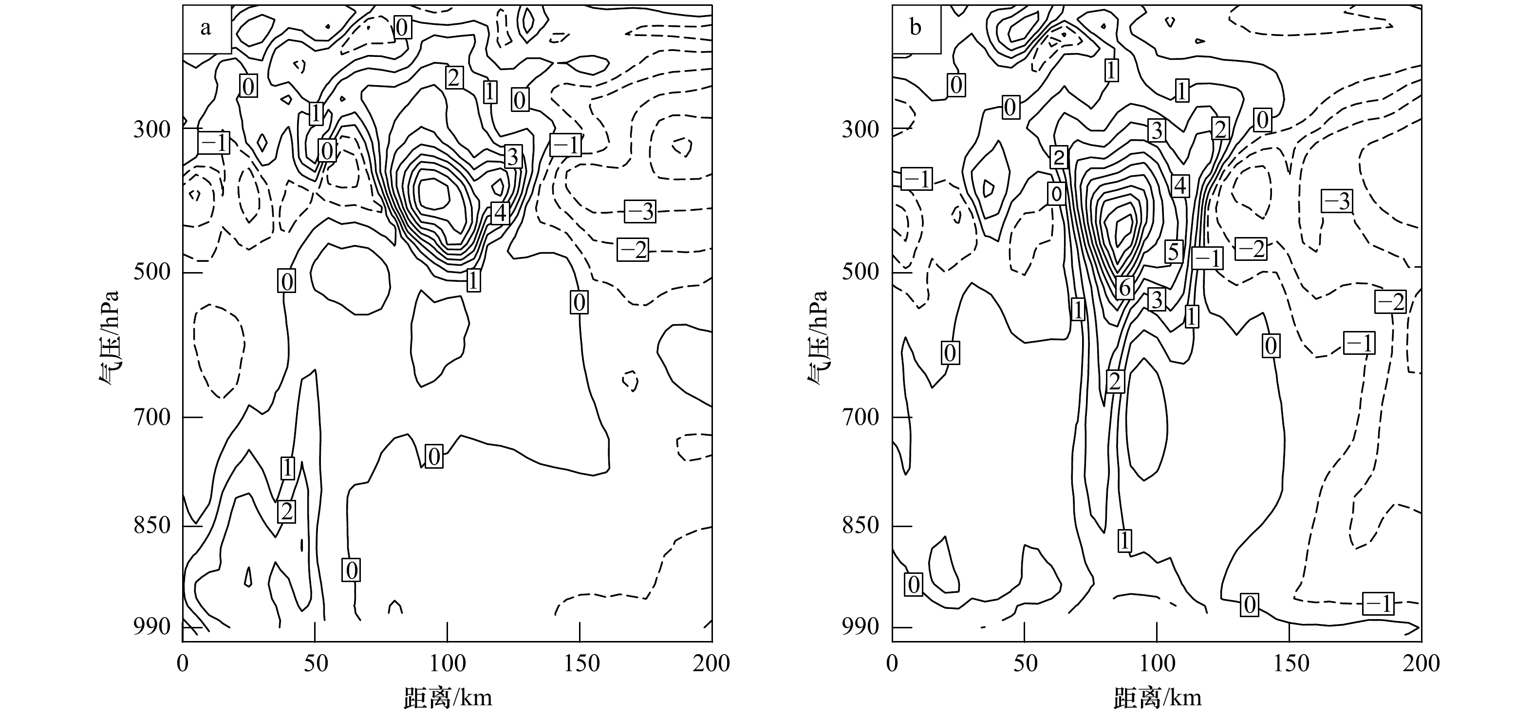
图 9 2006年8月10日06:00 UTC GFS试验(a)和JMA试验(b)温度距平(等值线,单位: K)
Fig. 9 Vertical cross sections of analyzed temperature anomalies (contour line, unit: K) for GFS (a) and JMA (b) experiments at 06:00 UTC on August 10, 2006
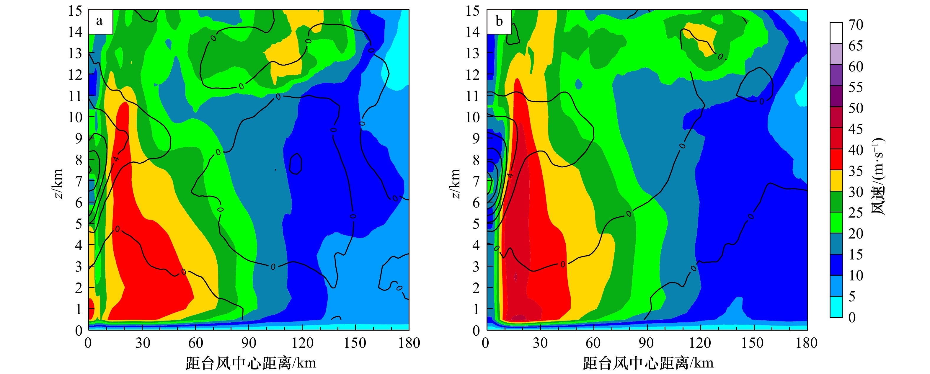
图 10 2006年8月10日06:00 UTC GFS试验(a)和JMA试验(b)台风轴对称切向风和温度距平(等值线,单位:K)
Fig. 10 Contour plot of azimuthally-averaged tangential wind and temperature deviated from the horizontal mean (contour line, unit: K) for GFS (a) and JMA (b) experiments at 06:00 UTC on August 10, 2006

图 11 2006年8月10日06:00 UTC至09:00 UTC,观测实况、GFS试验和JMA试验雷达组合反射率因子
Fig. 11 The radar combination reflectivity factor for observation, GFS, and JMA experiments from 06:00 UTC to 18:00 UTC on August 10, 2006
-
[1] 康斌. 我国台风灾害统计分析[J]. 中国防汛抗旱, 2016, 26(2): 36−40. doi: 10.3969/j.issn.1673-9264.2016.02.013Kang Bin. Statistical analysis of typhoon disaster in China[J]. China Flood & Drought Management, 2016, 26(2): 36−40. doi: 10.3969/j.issn.1673-9264.2016.02.013 [2] 陈锋, 冀春晓, 董美莹, 等. 雷达径向风速同化对台风麦莎模拟的影响[J]. 气象, 2012, 38(10): 1170−1181. doi: 10.7519/j.issn.1000-0526.2012.10.002Chen Feng, Ji Chunxiao, Dong Meiying, et al. The effects of radar radial velocity data assimilation on the simulation of Typhoon Matsa[J]. Meteorological Monthly, 2012, 38(10): 1170−1181. doi: 10.7519/j.issn.1000-0526.2012.10.002 [3] 李新峰. 雷达资料循环同化在台风“莫兰蒂”短时预报中的应用研究[D]. 南京: 南京大学, 2012.Li Xinfeng. Short-term forecasting through cyding assimilation of China coastal radar data for Typhoon Meranti at landfall[D]. Nanjing: Nanjing University, 2012. [4] 王明筠. 雷达反演同化对台风蔷薇(2008)强度和路径预报影响及其机制研究[D]. 南京: 南京大学, 2014.Wang Mingjun. The impacts of assimilating retrieved winds from Doppler radar observation on the intensity and track forecasts of Typhoon Jangmi (2008) and its mechanisms[D]. Nanjing: Nanjing University, 2014. [5] 沈菲菲, 闵锦忠, 许冬梅, 等. 双多普勒雷达资料同化在飓风“艾克”预报中的应用研究[J]. 海洋学报, 2016, 38(11): 60−72.Shen Feifei, Min Jinzhong, Xu Dongmei, et al. Application of assimilating dual Doppler radar data in forecast of hurricane Ike[J]. Haiyang Xuebao, 2016, 38(11): 60−72. [6] 李昕, 王元, 明杰, 等. 雷达径向风和反演风联合同化在台风灿都(2010)数值预报中的研究[J]. 气象, 2016, 42(6): 649−663. doi: 10.7519/j.issn.1000-0526.2016.06.001Li Xin, Wang Yuan, Ming Jie, et al. A combined radar data assimilation strategy of radial velocity and retrieved wind and its impact on the forecasting of tropical cyclone Chanthu (2010)[J]. Meteorological Monthly, 2016, 42(6): 649−663. doi: 10.7519/j.issn.1000-0526.2016.06.001 [7] 冯佳宁, 端义宏, 徐晶, 等. 雷达资料同化对2015年台风彩虹数值模拟改进[J]. 应用气象学报, 2017, 28(4): 399−413. doi: 10.11898/1001-7313.20170402Feng Jianing, Duan Yihong, Xu Jing, et al. Improving the simulation of Typhoon Mujigae (2015) based on radar data assimilation[J]. Journal of Applied Meteorological Science, 2017, 28(4): 399−413. doi: 10.11898/1001-7313.20170402 [8] 沈菲菲, 许冬梅, 闵锦忠, 等. 云尺度雷达资料的混合同化对台风“桑美”的数值模拟研究[J]. 海洋学报, 2018, 40(5): 48−61.Shen Feifei, Xu Dongmei, Min Jinzhong, et al. Assimilation of radar observations with En3DVAR at cloud-resolving scale for the prediction of Typhoon Saomai[J]. Haiyang Xuebao, 2018, 40(5): 48−61. [9] Shen F F, Xue M, Min J Z. A comparison of limited-area 3DVAR and ETKF-En3DVAR data assimilation using radar observations at convective scale for the prediction of Typhoon Saomai (2006)[J]. Meteorological Applications, 2017, 24(4): 628−641. [10] 戚佩霓, 沈菲菲, 寇蕾蕾, 等. 多普勒雷达资料同化在台风“灿都”(2010)预报中的应用研究[J]. 热带海洋学报, 2019, 38(2): 20−31.Qi Peini, Shen Feifei, Kou Leilei, et al. Experiments of assimilating Doppler radar data in forecast of Typhoon Chanthu[J]. Journal of Tropical Oceanography, 2019, 38(2): 20−31. [11] 刘青松, 董海萍, 郭卫东, 等. 不同背景场条件对同化多普勒雷达资料效果的影响[C]//创新驱动发展 提高气象灾害防御能力——S12航空与航天气象技术研究与应用. 北京: 中国气象学会, 2013: 8.Liu Qingsong, Dong Haiping, Guo Weidong, et al. Effects of different background field on assimilation of Doppler radar data[C]//Innovation-Driven Development, Improving the Defense Capability of Meteorological Disasters -- S12 Aerospace and Meteorological Technology Research and Application. Beijing: Chinese Meteorological Society, 2013: 8. [12] 公颖, 李俊. 不同背景场条件下AREM模式预报效果评估分析[J]. 气象科技, 2009, 37(1): 1−8. doi: 10.3969/j.issn.1671-6345.2009.01.001Gong Ying, Li Jun. Evaluation and analysis of AREM prediction under different background fields[J]. Meteorological Science and Technology, 2009, 37(1): 1−8. doi: 10.3969/j.issn.1671-6345.2009.01.001 [13] 李得勤, 段云霞, 周晓珊, 等. 两种背景场同化雷达资料对辽宁省一次暴雨预报的影响[J]. 高原气象, 2015, 34(4): 1107−1118. doi: 10.7522/j.issn.1000-0534.2014.00115Li Deqin, Duan Yunxia, Zhou Xiaoshan, et al. Numerical forecasting study of a rainstorm at Liaoning by assimilating radar data of two kinds of background fields[J]. Plateau Meteorological, 2015, 34(4): 1107−1118. doi: 10.7522/j.issn.1000-0534.2014.00115 [14] 朱红芳, 王东勇, 管兆勇, 等. 不同初始场条件对GRAPES模式数值预报的影响[J]. 气象学报, 2007, 65(4): 493−502.Zhu Hongfang, Wang Dongyong, Guan Zhaoyong, et al. Effects of different initial fields on GRAPES numerical prediction[J]. Acta Meteorologica Sinica, 2007, 65(4): 493−502. [15] 吕校华, 谭德权, 冉祥辉, 等. 超强台风“桑美”的特点及其成因分析[J]. 气象研究与应用, 2007, 28(S2): 70−73.Lü Xiaohua, Tan Dequan, Rang Xianghui, et al. Characteristics and analysis of cause of super typhoon “Saomai”[J]. Journal of Meteorological Research and Application, 2007, 28(S2): 70−73. [16] 余贞寿, 闵锦忠, 钟建锋, 等. 超强台风“桑美”(0608)近海观测特征研究[J]. 科技通报, 2012, 28(3): 21−27, 48. doi: 10.3969/j.issn.1001-7119.2012.03.005Yu Zhenshou, Min Jinzhong, Zhong Jianfeng, et al. Observational features of super Typhoon Saomai (2006) over coastal water of China[J]. Bulletin of Science and Technology, 2012, 28(3): 21−27, 48. doi: 10.3969/j.issn.1001-7119.2012.03.005 [17] Xue M, Wang D H, Gao J D, et al. The Advanced Regional Prediction System (ARPS), storm-scale numerical weather prediction and data assimilation[J]. Meteorology and Atmospheric Physics, 2003, 82(1): 139−170. [18] Brewster K, Hu M, Xue M, et al. Efficient assimilation of radar data at high resolution for short-range numerical weather prediction[C]//World Weather Research Program Symposium on Nowcasting and Very Short-Range Forecasting. New York: John Wiley and Sons, 2005. [19] Oye R, Mueller C, Smith S. Software for radar translation, visualization, editing, and interpolation[C]//Proceedings of the 27th Conference on Radar Meteorology. Vail, CO: American Meteorological Society, 1995: 359–361. [20] Lim K S S, Hong S Y. Development of an effective double-moment cloud microphysics scheme with prognostic cloud condensation nuclei (CCN) for weather and climate models[J]. Monthly Weather Review, 2010, 138(5): 1587−1612. doi: 10.1175/2009MWR2968.1 [21] Grell G A, Dévényi D. A generalized approach to parameterizing convection combining ensemble and data assimilation techniques[J]. Geophysical Research Letters, 2002, 29(14): 38-1−38-4. doi: 10.1029/2002GL015311 [22] Mlawer E J, Taubman S J, Brown P D, et al. Radiative transfer for inhomogeneous atmospheres: RRTM, a validated correlated-k model for the longwave[J]. Journal of Geophysical Research: Atmospheres, 1997, 102(D14): 16663−16682. doi: 10.1029/97JD00237 [23] Noh Y, Cheon W G, Hong S Y, et al. Improvement of the K-profile model for the planetary boundary layer based on large eddy simulation data[J]. Boundary-Layer Meteorology, 2003, 107(2): 401−427. doi: 10.1023/A:1022146015946 [24] Li Y Z, Wang X G, Xue M. Assimilation of radar radial velocity data with the WRF hybrid ensemble-3DVAR system for the prediction of hurricane Ike (2008)[J]. Monthly Weather Review, 2012, 140(11): 3507−3524. doi: 10.1175/MWR-D-12-00043.1 -

 下载:
下载:

计量
- 文章访问数: 553
- HTML全文浏览量: 156
- PDF下载量: 47
- 被引次数: 0
