Research of calibration of HY-2B altimeter based on tidal gauge along the coast of Zhuhai, Wanshan calibration site
-
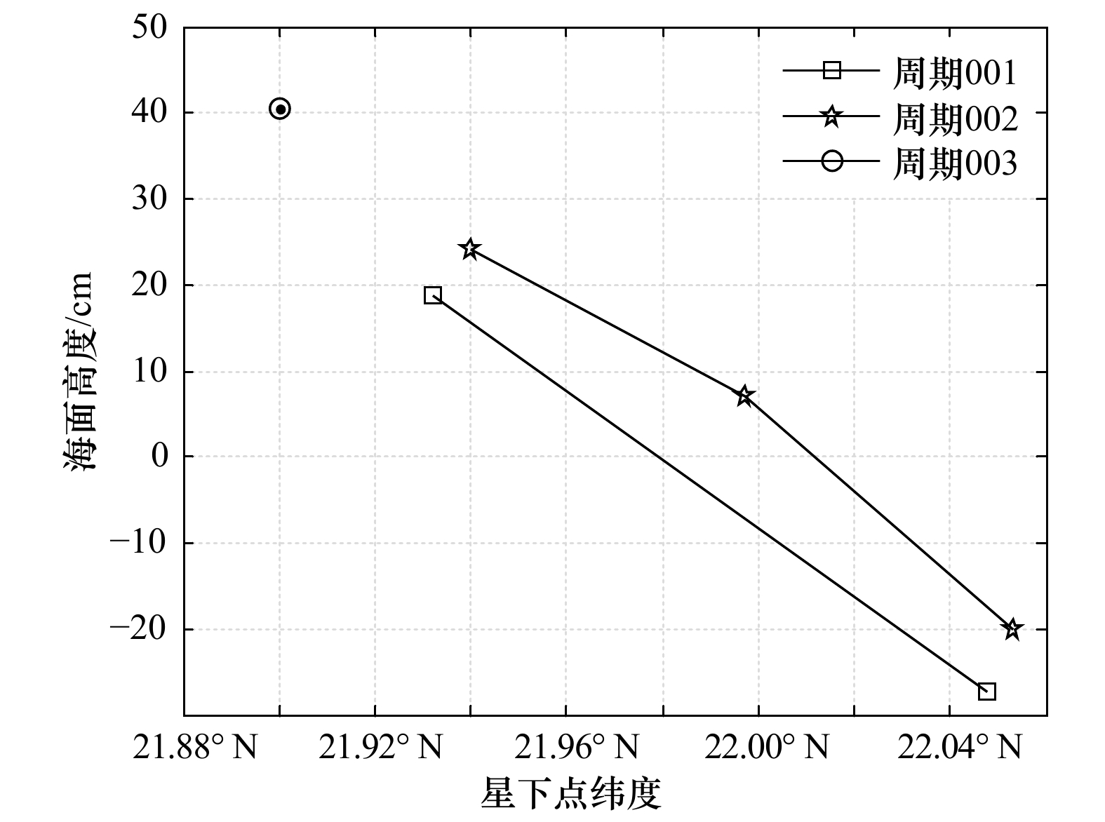
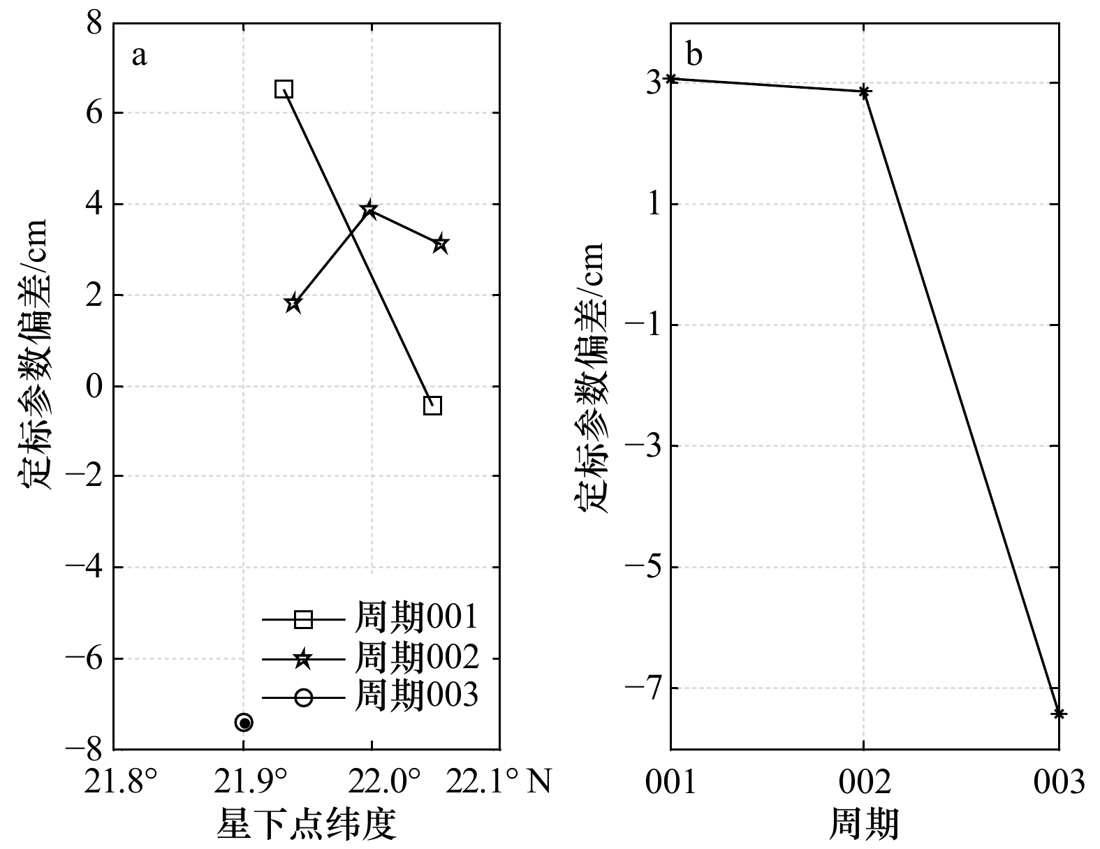
摘要: 随着我国海洋二号B卫星(HY-2B)于2018年10月发射成功,国家卫星海洋应用中心于珠海万山进行了HY-2B的在轨测试。试验利用沿岸验潮仪,在珠海万山直湾岛HY-2B过境轨道375的星下点附近进行了由2018年11月3日至12月12日的验潮仪定标试验。在试验期间,HY-2B共重访定标场星下点3次,定标结果表明:3个周期的HY-2B雷达高度计测量海面高度定标结果良好,定标参数分别为(3.06±3.48) cm、(2.85±1.03) cm、−7.41 cm;定标参数在前3个周期存在一定漂移,需要后续的定标工作以确定漂移原因。Abstract: After the launch of China’s HY-2B altimeter in October 2018, NSOAS (National Satellite Ocean Application Service) conducted a HY-2B altimetry calibration experiment in Wanshan, Zhuhai. The experiment used the tide gauge along the coast to conduct the calibration experiment from November 3, 2018 to December 12, 2018, near the sub-satellite point of the HY-2B transit orbit 375 on Zhiwan Island. During the experiment period, HY-2B revisited the calibration point three times, and the results showed that the three-period HY-2B altimetry calibration bias were (3.06±3.48) cm, (2.85±1.03) cm, −7.41 cm; there was a certain drift in the calibration bias in the first three cycles, and subsequent calibration work was required to determine the cause of the drift.
-
Key words:
- HY-2B /
- Wanshan calibration site /
- tide gauge /
- absolute calibration
-
表 1 万山定标场验潮仪位置与试验时间
Tab. 1 Position and time of tide gauge experiment in Wanshan calibration site
仪器ID 仪器类型 纬度 经度 布放时间 参考椭球体长半轴 参考椭器体扁率 验潮仪083248 RBR-solo 21.994 7°N 114.147 9°E 2018年11月3日至12月12日 6 378 136.3 m 1/298.257 表 2 参考椭球体参数
Tab. 2 Reference ellipsoid parameters
参数 T/P WGS84 半长轴/m 6 378 136.3 6 378 137 半短轴/m 6 356 751.600 563 6 356 752.314 245 18 扁率 1/298.257 1/298.257 223 563 -
[1] Bonnefond P, Exertier P, Laurain O, et al. Absolute calibration of Jason-1 and TOPEX/Poseidon altimeters in Corsica[J]. Marine Geodesy, 2003, 26(3/4): 261−284. [2] Chen Chuntao, Zhu Jianhua, Zhai Wanlin, et al. Absolute calibration of HY-2A and Jason-2 altimeters for sea surface height using GPS buoy in Qinglan, China[J]. Journal of Oceanology and Limnology, 2019, 37(5): 1533−1541. doi: 10.1007/s00343-019-8216-8 [3] 翟万林, 陈春涛, 闫龙浩. 基于GPS浮标的高度计海面高度产品检验技术进展[J]. 海洋测绘, 2012, 32(6): 40−43. doi: 10.3969/j.issn.1671-3044.2012.06.012Zhai Wanlin, Chen Chuntao, Yan Longhao. The technology progress in the calibration of satellite altimeter using GPS-buoys[J]. Hydrographic Surveying and Charting, 2012, 32(6): 40−43. doi: 10.3969/j.issn.1671-3044.2012.06.012 [4] Fund F, Perosanz F, Testut L, et al. An integer precise point positioning technique for sea surface observations using a GPS buoy[J]. Advances in Space Research, 2013, 51(8): 1311−1322. doi: 10.1016/j.asr.2012.09.028 [5] Watson C, White N, Coleman R, et al. TOPEX/Poseidon and Jason-1: Absolute calibration in Bass Strait, Australia[J]. Marine Geodesy, 2004, 27(1/2): 107−131. [6] 闫龙浩, 陈春涛, 翟万林, 等. GPS浮标测高精度影响因素研究[J]. 中国工程科学, 2014, 16(6): 102−108. doi: 10.3969/j.issn.1009-1742.2014.06.015Yan Longhao, Chen Chuntao, Zhai Wanlin, et al. Influencing factors research of GPS buoy measurement precision[J]. Engineering Science, 2014, 16(6): 102−108. doi: 10.3969/j.issn.1009-1742.2014.06.015 [7] Watson C. Satellite altimeter calibration and validation using GPS buoy technology[D]. Tasmania: University of Tasmania, 2005. [8] White N J, Coleman R, Church J A, et al. A southern hemisphere verification for the TOPEX/POSEIDON satellite altimeter mission[J]. Journal of Geophysical Research: Oceans, 1994, 99(C12): 24505−24516. doi: 10.1029/94JC01382 [9] 蒋兴伟, 林明森, 宋庆君. 中国海洋卫星雷达高度计海上定标场建设初探[J]. 海洋开发与管理, 2016, 33(5): 8−15. doi: 10.3969/j.issn.1005-9857.2016.05.002Jiang Xingwei, Lin Mingsen, Song Qingjun. On the construction of China’s ocean satellite radar altimetry calibration site[J]. Ocean Development and Management, 2016, 33(5): 8−15. doi: 10.3969/j.issn.1005-9857.2016.05.002 [10] Yang Lei, Zhou Xinghua, Mertikas S P, et al. First calibration results of Jason-2 and SARAL/AltiKa satellite altimeters from the Qianli Yan permanent Cal/Val facilities, China[J]. Advances in Space Research, 2017, 59(12): 2831−2842. doi: 10.1016/j.asr.2017.02.044 [11] Andersen O B. The DTU10 Global Gravity field and mean sea surface[C]//Second International Symposium of the International Gravity Field Service. Fairbanks, Alaska, 2011. [12] Erofeeva S, Padman L, Howard S L. Tide Model Driver (TMD) version 2.5, Toolbox for Matlab[EB/OL]. (2020-03-14). https://www.github.com/EarthAndSpaceResearch/TMD_Matlab_Toolbox_v2.5,GitHub. -


 下载:
下载:


