

The design of the stations of marine environmental monitoring buoys in the Chinese sturgeon nature reserve in the Changjiang River Estuary
-
摘要: 长江口是众多洄游性鱼类重要的栖息场所,其复杂的环境条件影响着该水域水生生物的生长和繁殖过程。海洋环境监测浮标能够对诸多环境要素进行长期、连续、实时和大范围的监测,是现代海洋环境自动观测系统中的重要组成部分。为在长江口中华鲟自然保护区及其邻近水域组建合理有效的浮标监测网络,本研究基于海上实测调查数据,使用普通克里金法模拟了多种环境要素的空间分布,在此基础上比较了分层随机采样设计中不同分层方案和站点数量变化对监测效果的影响,结果显示:(1)盐度要素在层数为3的分层随机采样方法中采样精度更高,水温、溶解氧和化学需氧量要素在层数为2的采样设计中采样效果更好;(2)站点数越多,相对误差越集中并趋向于0,并当站点数多于30时,采样估测准确性逐渐趋于稳定;(3)各季节中,秋季盐度要素中层数为2的采样准确性更高;与其他3季以及总体相对误差结果相比,冬季化学需氧量要素的采样效果比其他3个季节要差。在今后长江口中华鲟自然保护区水域组建环境监测浮标网络时,建议采用3层的分层随机采样作为盐度监测的分层标准,且站点数量要大于50个;使用2层的分层随机采样作为其他多种水文环境要素监测的分层标准,且站点数量要大于30个。Abstract: The Changjiang River Estuary is an important habitat for many migratory fishes, and its complex environmental conditions affect the growth and reproduction of aquatic organisms in this area. Marine environmental monitoring buoys are capable of long-term, continuous, real-time and large-scale monitoring of many environmental factors, and are an important part of the modern marine environmental automatic observation system. To establish a reasonable and effective buoy monitoring network for the Chinese sturgeon nature reserve and its adjacent waters in the Changjiang River Estuary , this study used Ordinary Kriging (OK) method to simulate the spatial distribution of various environmental factors, and then compared the effects of different strata design and sample size of Stratified Random Sampling (StRS) on the monitoring results. The results showed that: (1) the sampling accuracy of salinity was better when the stratum of StRS was 3, and water temperature, dissolved oxygen and chemical oxygen demand (COD) was better when the stratum was 2; (2) the relative estimation errors became more concentrated and tended to 0 value with the increase of sample size, and when the sample size was larger than 30, the accuracy tended to be stable gradually; (3) the sampling accuracy of salinity in autumn was different to the other three seasons, and the sampling effect of COD in winter was worst. In the future, when setting up an environmental monitoring buoy network in the Chinese sturgeons nature reserve in the Changjiang River Estuary, it is suggest to adopt three stratum stratified random sampling for salinity monitoring, and the number of stations should be more than 50. When taking various hydrological environments as the monitoring target, it is recommended to use two stratified standard, and the number of stations should be more than 30.
-

图 1 长江口中华鲟自然保护区及其邻近水域综合监测调查站点
Fig. 1 Comprehensive monitoring and investigation stations in the Chinese sturgeon nature reserve and its adjacent waters in the Changjiang River Estuary
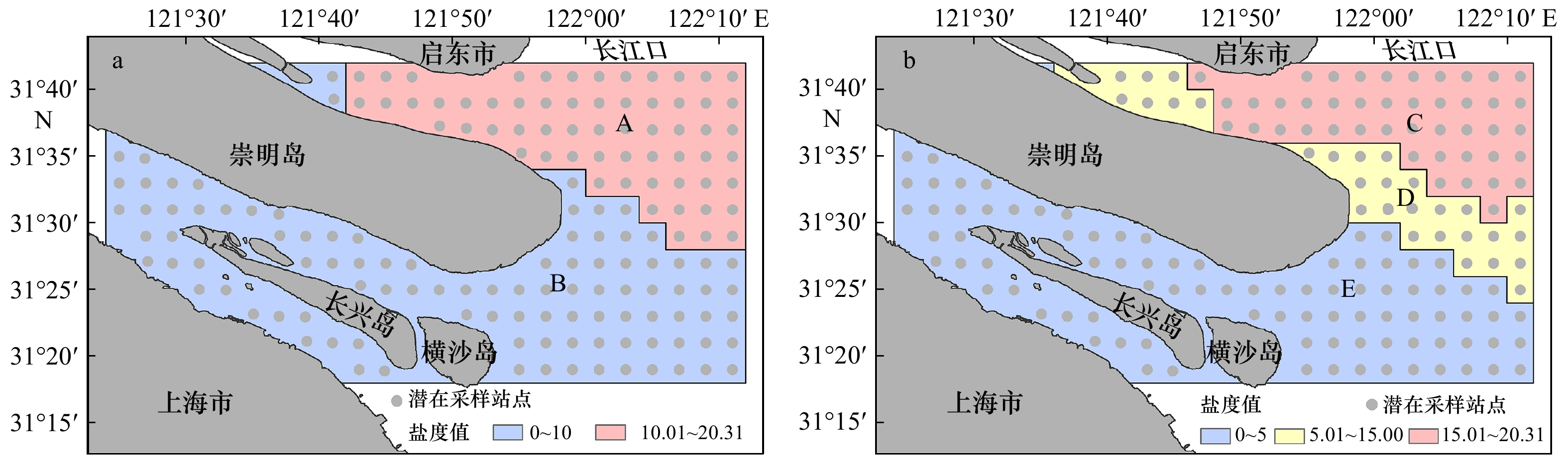
图 2 长江口中华鲟自然保护区及其邻近水域使用分层随机采样的分层划分
a. 2层分层随机采样方法;b. 3层分层随机采样方法
Fig. 2 Stratified design of stratified random sampling in the Chinese sturgeon nature reserve and its adjacent waters in the ChangjiangRiver Estuary
a. Two stratum stratified random sampling; b. three stratum stratified random sampling
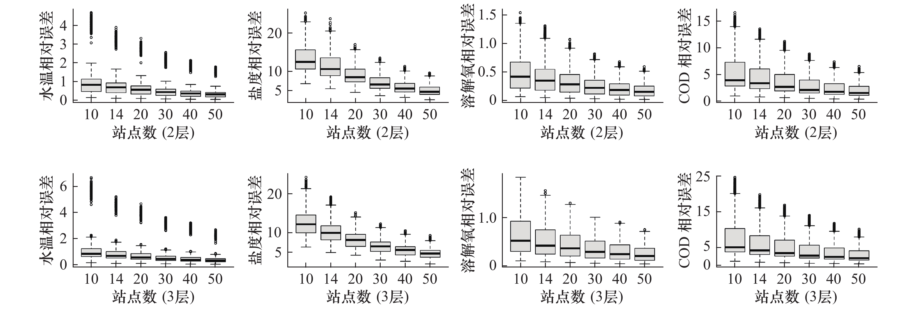
图 4 各环境要素的相对误差随监测站点数量增加的变化趋势
Fig. 4 The variation trend of relative estimation error with the increase of the monitoring sample size of various environmental factors
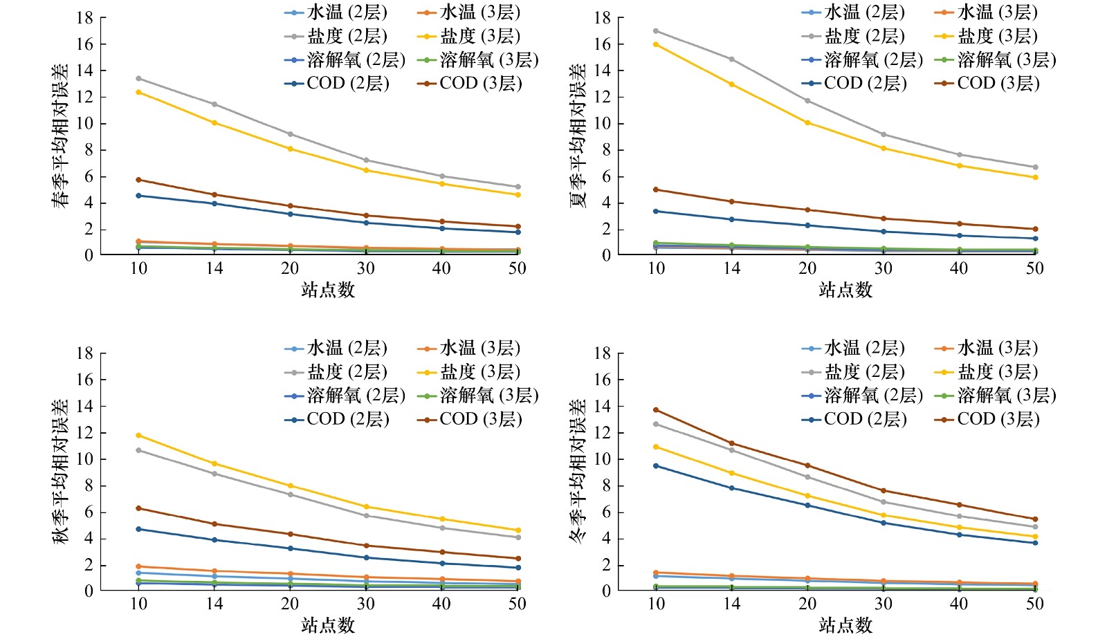
图 5 不同季节各环境要素的平均相对误差随监测站点数量增加的变化趋势
Fig. 5 The variation trend of average relative estimation error of various environmental factors in different seasons with the increase of the monitoring sample size
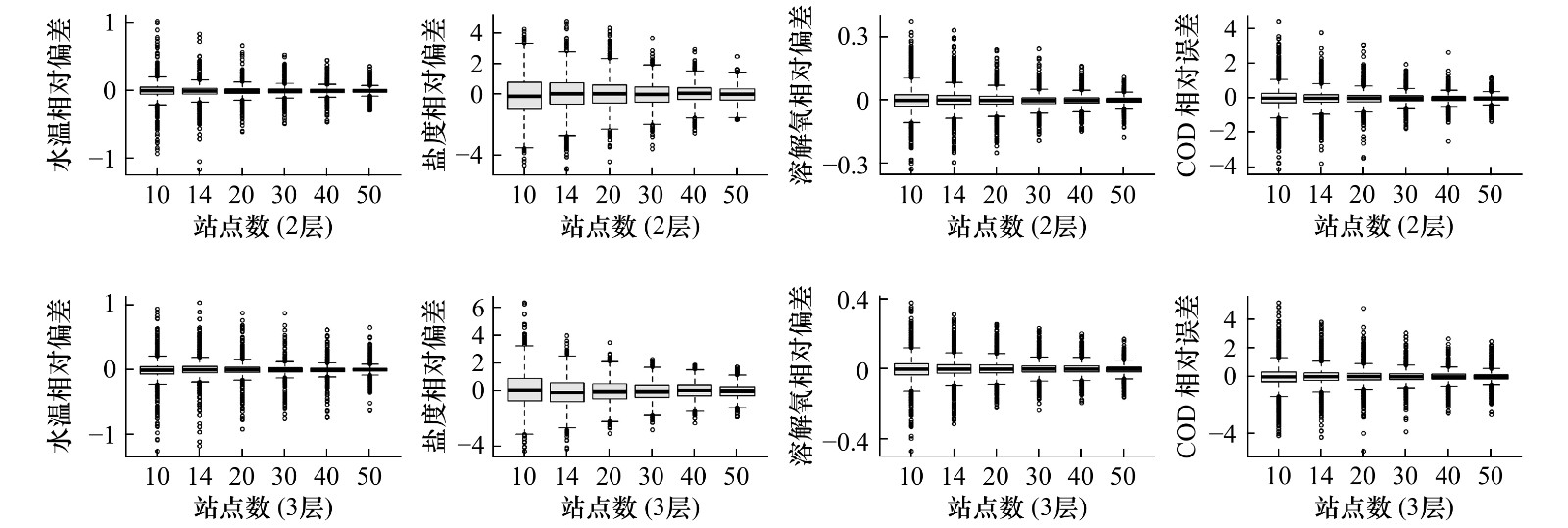
图 6 各环境要素的相对偏差随监测站点数量增加的变化趋势
Fig. 6 The variation trend of relative bias with the increase of the monitoring sample size of various environmental factors
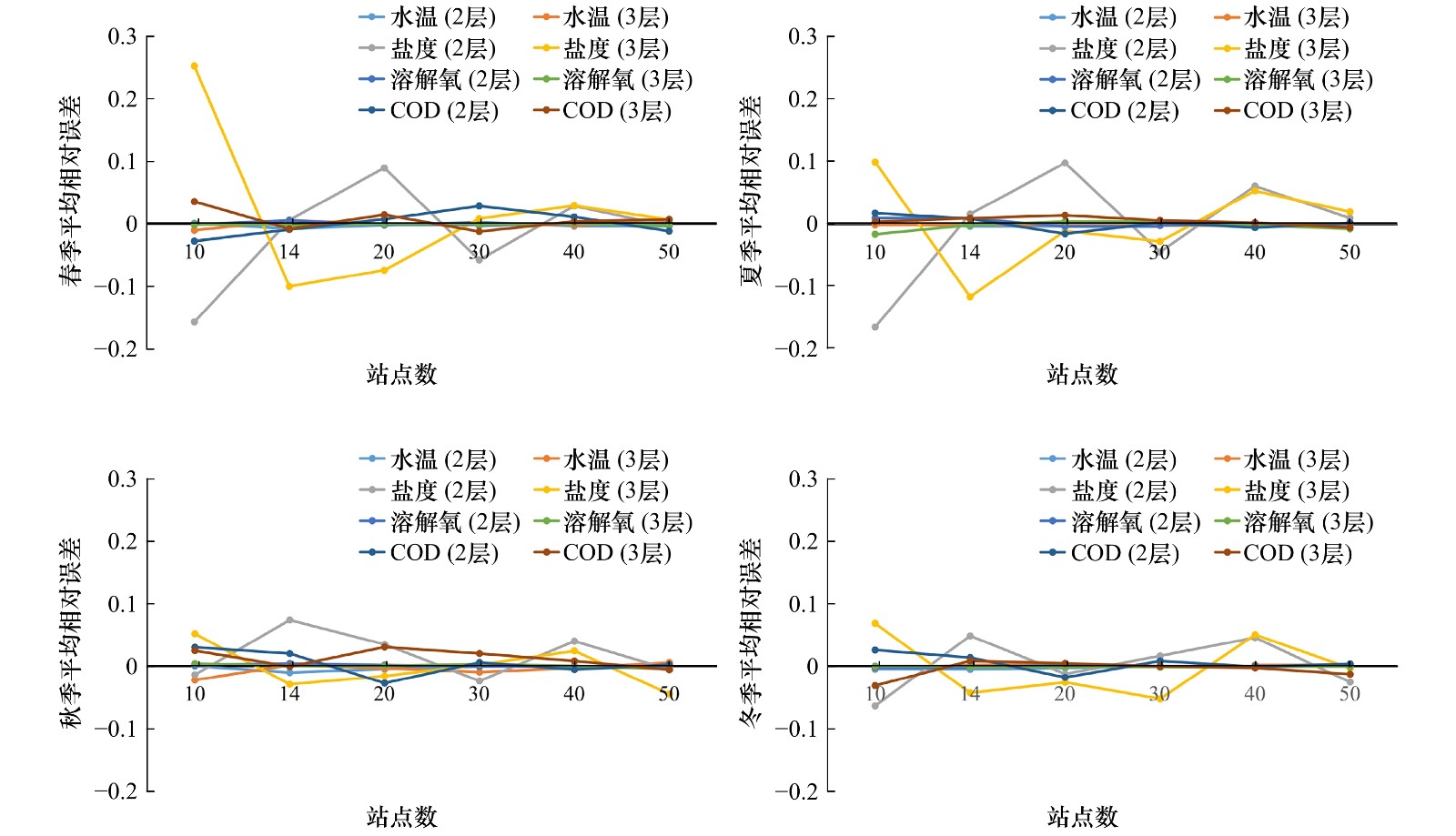
图 7 不同季节各环境要素的相对偏差随监测站点数量增加的变化趋势
Fig. 7 The variation trend of average relative bias of various environmental factors in different seasons with the increase of the monitoring sample size
表 1 分层随机采样的分层设计及站点数分布
Tab. 1 Stratified design and sample size distribution of stratified random sampling
区域分层 盐度范围 $ {{N_h}}$ $ {{w_h}}$ $ {{S_h}}$ $ {{n_{h10}}}$ $ {{n_{h{\rm{14}}}}}$ $ {{n_{h20}}}$ $ {{n_{h{\rm{30}}}}}$ $ {{n_{h{\rm{40}}}}}$ $ {{n_{h{\rm{5}}0}}}$ A >10 61 0.38 5.80 4 5 8 12 16 19 B ≤10 99 0.62 5.57 6 9 12 18 24 31 C >15 44 0.28 1.92 2 3 5 7 9 11 D 5~15 29 0.18 7.77 6 8 11 17 23 28 E ≤5 87 0.54 0.98 2 3 4 6 8 11 注:$ {{n_h}}$表示h层可被采样的样本数量;$ {{w_h}}$表示h层的权重;$ {{S_h}}$表示h层的样本方差;$ {{n_{h10}}}$($ {{n_{h{\rm{14}}}}}$, $ {{n_{h20}}}$, $ {{n_{h{\rm{30}}}}}$, $ {{n_{h{\rm{40}}}}}$, ${n_{h{\rm{5}}0}}$)表示总站点数量为10(14, 20, 30, 40, 50)时分配到h层中的站点数量。  下载: 导出CSV
表 2 各环境要素不同采样设计结果的平均相对误差
Tab. 2 The average relative estimation error of different sampling design results of various environmental factors
站点数 水温 盐度 溶解氧 COD 2层 3层 2层 3层 2层 3层 2层 3层 10 1.012 1.237 13.418 12.752 0.535 0.681 5.500 7.664 14 0.840 1.008 11.455 10.385 0.447 0.553 4.574 6.232 20 0.693 0.848 9.193 8.315 0.365 0.464 3.769 5.250 30 0.544 0.678 7.190 6.661 0.287 0.371 2.982 4.201 40 0.453 0.582 6.001 5.607 0.240 0.318 2.470 3.600 50 0.387 0.486 5.188 4.797 0.206 0.266 2.105 3.016
下载: 导出CSV
表 3 各环境要素不同采样设计结果的平均相对偏差
Tab. 3 The average relative bias of different sampling design results of various environmental factors
站点数 水温 盐度 溶解氧 COD 2层 3层 2层 3层 2层 3层 2层 3层 10 0.000 −0.009 −0.099 0.119 0.003 −0.003 0.012 0.009 14 −0.006 0.003 0.037 −0.071 0.005 −0.001 0.009 0.003 20 −0.002 0.000 0.053 −0.031 0.000 0.001 −0.013 0.016 30 0.000 −0.003 −0.027 −0.017 −0.001 0.001 0.012 0.004 40 −0.001 −0.001 0.044 0.040 0.001 0.000 0.000 0.003 50 −0.001 0.003 −0.006 −0.005 0.001 −0.003 0.000 −0.004
下载: 导出CSV
-
[1] Simier M, Laurent C, Ecoutin J M, et al. The Gambia River estuary: a reference point for estuarine fish assemblages studies in West Africa[J]. Estuarine Coastal and Shelf Science, 2006, 69(3/4): 615−628. [2] 罗秉征, 沈焕庭. 三峡工程与河口生态环境[M]. 北京: 科学出版社, 1994.Luo Bingzheng, Shen Huanting. The Three Gorges Project and the Estuary Ecological Environment[M]. Beijing: Science Press, 1994. [3] 程海峰, 刘杰, 王珍珍, 等. 长江口水文监测站网选址合理性分析及优化[J]. 人民长江, 2019, 50(6): 70−75.Cheng Haifeng, Liu Jie, Wang Zhenzhen, et al. Study on site selection and optimization of hydrologic stations network in Yangtze River Estuary[J]. Yangtze River, 2019, 50(6): 70−75. [4] 顾圣华, 李琪. 长江口水文监测站网布局研究[J]. 华东师范大学学报(自然科学版), 2015(4): 1−6.Gu Shenghua, Li Qi. Study on layout of hydrologic network in the Changjiang Estuary[J]. Journal of East China Normal University (Natural Science), 2015(4): 1−6. [5] 史赟荣, 晁敏, 全为民, 等. 长江口鱼类群落的多样性分析[J]. 中国水产科学, 2012, 19(6): 1051−1059.Shi Yunrong, Chao Min, Quan Weimin, et al. Fish community diversity analyses in the Yangtze River Estuary, China[J]. Journal of Fishery Sciences of China, 2012, 19(6): 1051−1059. [6] 徐超, 王思凯, 赵峰, 等. 基于Ecopath模型的长江口生态系统营养结构和能量流动研究[J]. 海洋渔业, 2018, 40(3): 309−318. doi: 10.3969/j.issn.1004-2490.2018.03.006Xu Chao, Wang Sikai, Zhao Feng, et al. Trophic structure and energy flow of the Yangtze Estuary ecosystem based on the analysis with Ecopath model[J]. Marine Fisheries, 2018, 40(3): 309−318. doi: 10.3969/j.issn.1004-2490.2018.03.006 [7] 李建生, 林楠, 凌建忠. 春夏季长江口邻近水域仔稚鱼种类组成和丰度的月变化[J]. 中国水产科学, 2018, 25(3): 586−594.Li Jiansheng, Lin Nan, Ling Jianzhong. Temporal variation in the composition and abundance of fish larvae and juveniles off the Yangtze River Estuary in spring and summer[J]. Journal of Fishery Sciences of China, 2018, 25(3): 586−594. [8] 张志. 浅谈海洋资料浮标观测的地位和发展[J]. 海洋技术, 1998, 17(2): 44−46.Zhang Zhi. A brief discussion on the status and development of ocean data buoy observation[J]. Ocean Technology, 1998, 17(2): 44−46. [9] 王波, 李民, 刘世萱, 等. 海洋资料浮标观测技术应用现状及发展趋势[J]. 仪器仪表学报, 2014, 35(11): 2401−2414.Wang Bo, Li Min, Liu Shixuan, et al. Current status and trend of ocean data buoy observation technology applications[J]. Chinese Journal of Scientific Instrument, 2014, 35(11): 2401−2414. [10] 杨明远. 基于Argo数据的海洋要素场三维网格化技术研究[D]. 郑州: 战略支援部队信息工程大学, 2018.Yang Mingyuan. Research on data griding of three-dimensional oceanic element fields based on Argo data[D]. Zhengzhou: Information Engineering University, 2018. [11] 杨建东. 丽江市水文站网布设研究[J]. 人民长江, 2017, 48(S1): 103−106.Yang Jiandong. Study on the layout of hydrological stations in Lijiang[J]. Yangtze River, 2017, 48(S1): 103−106. [12] 李禾澍, 王栋, 王远坤. 基于信息熵的多目标水文站网优化探讨[J]. 南京大学学报(自然科学), 2017, 53(2): 326−332.Li Heshu, Wang Dong, Wang Yuankun. Entropy based multi-objective optimization for hydrologic networks[J]. Journal of Nanjing University (Natural Sciences), 2017, 53(2): 326−332. [13] 唐政, 单秀娟, 金显仕. 渔业资源调查采样设计优化研究进展[J]. 海洋科学, 2019, 43(4): 88−97. doi: 10.11759/hykx20180910001Tang Zheng, Shan Xiujuan, Jin Xianshi. A review of optimization of sampling design for fishery-independent surveys[J]. Marine Sciences, 2019, 43(4): 88−97. doi: 10.11759/hykx20180910001 [14] Rago P J. Fishery independent sampling: survey techniques and data analyses[M]//Musick J A. Management Techniques for Elasmobranch Fisheries. Roma: Food & Agriculture Organization, 2005: 201−215. [15] Xu Binduo, Ren Yiping, Chen Yong, et al. Optimization of stratification scheme for a fishery-independent survey with multiple objectives[J]. Acta Oceanologica Sinica, 2015, 34(12): 154−169. [16] Smith S J, Tremblay M J. Fishery-independent trap surveys of lobsters (Homarus americanus): design considerations[J]. Fisheries Research, 2003, 62(1): 65−75. [17] Zhao Jing, Cao Jie, Tian Siquan, et al. Evaluating sampling designs for demersal fish communities[J]. Sustainability, 2018, 10(8): 1−23. [18] Cochran W G. Sampling Techniques[M]. 3rd ed. New York: John Wiley & Sons, 1977. [19] 韩青鹏, 单秀娟, 金显仕, 等. 多目标资源调查站位优化设计—以渤海为例[J]. 渔业科学进展, 2019, 40(1): 1−11.Han Qingpeng, Shan Xiujuan, Jin Xianshi, et al. Study on optimizing sampling design of multi-objective fishery-independent surveys: a case study in the Bohai Sea[J]. Progress in Fishery Sciences, 2019, 40(1): 1−11. [20] 赵静, 章守宇, 林军, 等. 不同采样设计评估鱼类群落效果比较[J]. 应用生态学报, 2014, 25(4): 1181−1187.Zhao Jing, Zhang Shouyu, Lin Jun, et al. A comparative study of different sampling designs in fish community estimation[J]. Chinese Journal of Applied Ecology, 2014, 25(4): 1181−1187. [21] McNeish D M, Harring J R. Clustered data with small sample sizes: comparing the performance of model-based and design-based approaches[J]. Communications in Statistics-Simulation and Computation, 2017, 46(2): 855−869. [22] Brus D J, De Gruijter J J. Random sampling or geostatistical modelling? Choosing between design-based and model-based sampling strategies for soil (with Discussion)[J]. Geoderma, 1997, 80(1/2): 1−44. [23] Rivoirard J, Wieland K. Correcting for the effect of daylight in abundance estimation of juvenile haddock (Melanogrammus aeglefinus) in the north sea: an application of Kriging with external drift[J]. ICES Journal of Marine Science, 2001, 58(6): 1272−1285. [24] Chen Yunlong, Shan Xiujuan, Jin Xianshi, et al. A comparative study of spatial interpolation methods for determining fishery resources density in the Yellow Sea[J]. Acta Oceanologica Sinica, 2016, 35(12): 65−72. [25] Li Bai, Cao Jie, Guan Lisha, et al. Estimating spatial non-stationary environmental effects on the distribution of species: a case study from American lobster in the Gulf of Maine[J]. ICES Journal of Marine Science, 2018, 75(4): 1473−1482. [26] Appice A, Malerba D. Leveraging the power of local spatial autocorrelation in geophysical interpolative clustering[J]. Data Mining and Knowledge discovery, 2014, 28(5/6): 1266−1313. [27] Zimmerman D, Pavlik C, Ruggles A, et al. An experimental comparison of ordinary and universal kriging and inverse distance weighting[J]. Mathematical Geology, 1999, 31(4): 375−390. [28] Mueller T G, Pusuluri N B, Mathias K K, et al. Map quality for ordinary kriging and inverse distance weighted interpolation[J]. Soil Science Society of America Journal, 2004, 68(6): 2042−2047. [29] Ding Qian, Wang Yong, Zhuang Dafang. Comparison of the common spatial interpolation methods used to analyze potentially toxic elements surrounding mining regions[J]. Journal of Environmental Management, 2018, 212: 23−31. [30] Isaaks E H, Srivastava R M. Spatial continuity measures for probabilistic and deterministic geostatistics[J]. Mathematical Geology, 1988, 20(4): 313−341. [31] Stow C A, Jolliff J, Mcgillicuddy Jr D J, et al. Skill assessment for coupled biological/physical models of marine systems[J]. Journal of Marine Systems, 2009, 76(1/2): 4−15. [32] 沈焕庭, 茅志昌, 朱建荣. 长江河口盐水入侵[M]. 北京: 海洋出版社, 2003.Shen Huanting, Mao Zhichang, Zhu Jianrong. Saltwater Intrusion in the Changjiang Estuary[M]. Beijing: China Ocean Press, 2003. [33] Neyman J. On the two different aspects of the representative method: the method of stratified sampling and the method of purposive selection[J]. Journal of the Royal Statistical Society, 1934, 97(4): 558−625. [34] Chen Yong. A Monte Carlo study on impacts of the size of subsample catch on estimation of fish stock parameters[J]. Fisheries Research, 1996, 26(3/4): 207−223. [35] Nalder I A, Wein R W. Spatial interpolation of climatic Normals: test of a new method in the Canadian boreal forest[J]. Agricultural and Forest Meteorology, 1998, 92(4): 211−225. [36] Goovaerts P. Geostatistics for Natural Resources Evaluation[M]. New York: Oxford University Press, 1997: 483. [37] Wang Jing, Xu Binduo, Zhang Chongliang, et al. Evaluation of alternative stratifications for a stratified random fishery-independent survey[J]. Fisheries Research, 2018, 207: 150−159. [38] 孔亚珍, 贺松林, 丁平兴, 等. 长江口盐度的时空变化特征及其指示意义[J]. 海洋学报, 2004, 26(4): 9−18.Kong Yazhen, He Songlin, Ding Pingxing, et al. Characteristics of temporal and spatial variation of salinity and their indicating significance in the Changjiang Estuary[J]. Haiyang Xuebao, 2004, 26(4): 9−18. [39] 吴晓丹, 宋金明, 李学刚. 长江口邻近海域水团特征与影响范围的季节变化[J]. 海洋科学, 2014, 38(12): 110−119. doi: 10.11759/hykx20140305001Wu Xiaodan, Song Jinming, Li Xuegang. Seasonal variation of water mass characteristic and influence area in the Yangtze Estuary and its adjacent waters[J]. Marine Sciences, 2014, 38(12): 110−119. doi: 10.11759/hykx20140305001 [40] Liu Yong, Chen Yong, Cheng Jiahua. A comparative study of optimization methods and conventional methods for sampling design in fishery-independent surveys[J]. ICES Journal of Marine Science, 2009, 66(9): 1873−1882. [41] 王劲峰, 姜成晟, 李连发, 等. 空间抽样与统计推断[M]. 北京: 科学出版社, 2009.Wang Jinfeng, Jiang Chengsheng, Li Lianfa, et al. Spatial Sampling and Statistical Inference[M]. Beijing: Science Press, 2009. [42] Simmonds E J, Fryer R J. Which are better, random or systematic acoustic surveys? A simulation using North Sea herring as an example[J]. Journal of Marine Science, 1996, 53(1): 39−50. [43] 范海梅, 纪焕红, 刘鹏霞, 等. 海洋环境监测站位优化方法与应用[J]. 上海环境科学, 2019, 38(3): 115−119.Fan Haimei, Ji Huanhong, Liu Pengxia, et al. The optimisation method for marine environmental monitoring siting and its application[J]. Shanghai Environmental Sciences, 2019, 38(3): 115−119. [44] 范海梅, 徐韧, 李丙瑞, 等. 基于关键要素分布特征的长江口及其邻近海域分区研究[J]. 海洋学研究, 2011, 29(4): 50−56. doi: 10.3969/j.issn.1001-909X.2011.04.007Fan Haimei, Xu Ren, Li Bingrui, et al. Partition study based on the distributions of key indicators in Changjiang River Estuary and its adjacent sea area[J]. Journal of Marine Sciences, 2011, 29(4): 50−56. doi: 10.3969/j.issn.1001-909X.2011.04.007 -


计量
- 文章访问数: 865
- HTML全文浏览量: 327
- PDF下载量: 41
- 被引次数: 0
