

Risk assessment of submarine landslide based on spectral clustering
-
摘要: 海底滑坡的危险性评价与分区,对海洋工程设施的选址和危险预防具有指导作用。本文基于无监督机器学习的谱聚类算法对黄河口埕岛海域展开了海底滑坡危险性评价,构建了输入参数为9、输出类别为4、核函数参数为0.08的海底滑坡危险性评价模型。使用该模型进行评价,将研究区分为了海底滑坡危险性高、较高、较低和低的区域。评价结果与地质环境因素分布特征对比显示,最重要的影响因素为海底沉积物类型和水动力作用,最重要的触发因子为液化。模型参数分析结果显示,合理简化输入因子可获得精度略低的评价结果,而核函数参数是影响评价准确性的重要指标。以上研究表明,谱聚类算法能够较好地用于海底滑坡危险性评价,数据类别丰富度和精度是影响评价精细程度的重要因素。Abstract: The risk assessment and zoning of submarine landslides can guide the site selection and risk prevention of offshore engineering facilities. In this paper, an unsupervised machine learning spectral analysis algorithm was used to evaluate the risk of submarine landslides in the Chengdao sea area of the Yellow River Estuary. A model of submarine landslides risk assessment with 9 input parameters, 4 output parameters and 0.08 as kernel function parameters is constructed. By using this model, the study area can be divided into 4 parts: high, quite high, quite low and low risk of submarine landslide. The comparison between the evaluation results and the distribution characteristics of geological environment factors show that the most important factors are the type of seafloor sediment and hydrodynamic action, and the most important trigger factor is liquefaction. The analysis results of model parameters present that the evaluation results with slightly lower accuracy can be obtained by reasonably simplifying the input factors, and the kernel function parameter is important index affecting the evaluation accuracy. The above research shows that the unsupervised machine learning algorithm can be well used in the risk assessment of submarine landslides, and the richness and accuracy of data categories are important factors affecting the assessment accuracy.
-
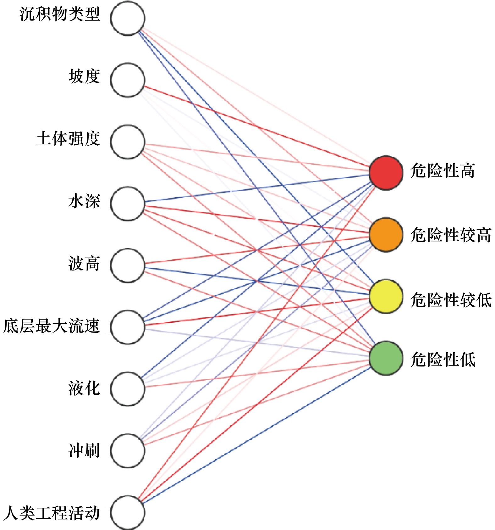
图 2 海底滑坡危险性评价网络结构示意图
图中左侧为网络输入因子类别,右侧为输出因子类别,连线表示聚类的左右关系示意,并非一一对应关系
Fig. 2 Schematic diagram of submarine landslide risk assessment network structure
The left side is the network input factor category, and the right side is the output factor category. The connecting line indicates the left-right relationship of clustering, not one-to-one correspondence
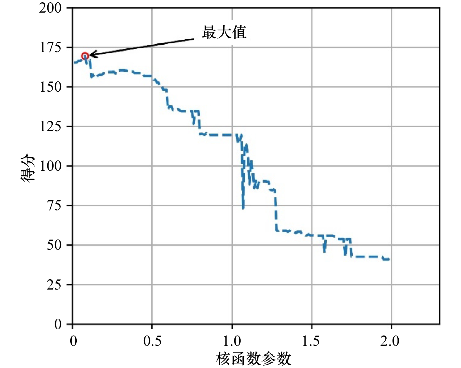
图 3 评价网络得分随核函数参数的变化
Fig. 3 Evaluation network score changes with kernel function parameters
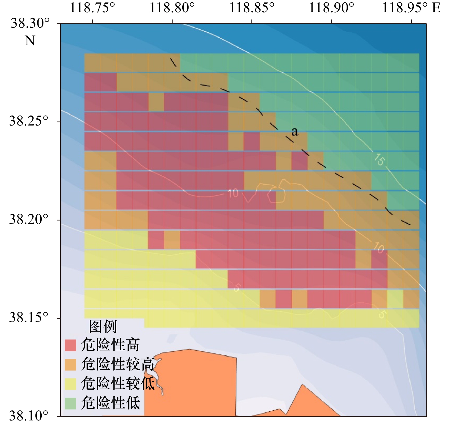
图 4 黄河口海底滑坡危险性评价结果
虚线a为危险性较高和危险性低分区间的突变界限,由海底沉积物类型的突变引起
Fig. 4 Risk assessment result of submarine landslides in the Yellow River Estuary
The dotted line a is the mutation boundary between high risk and low risk zones, which is caused by the mutation of seabed sediment types
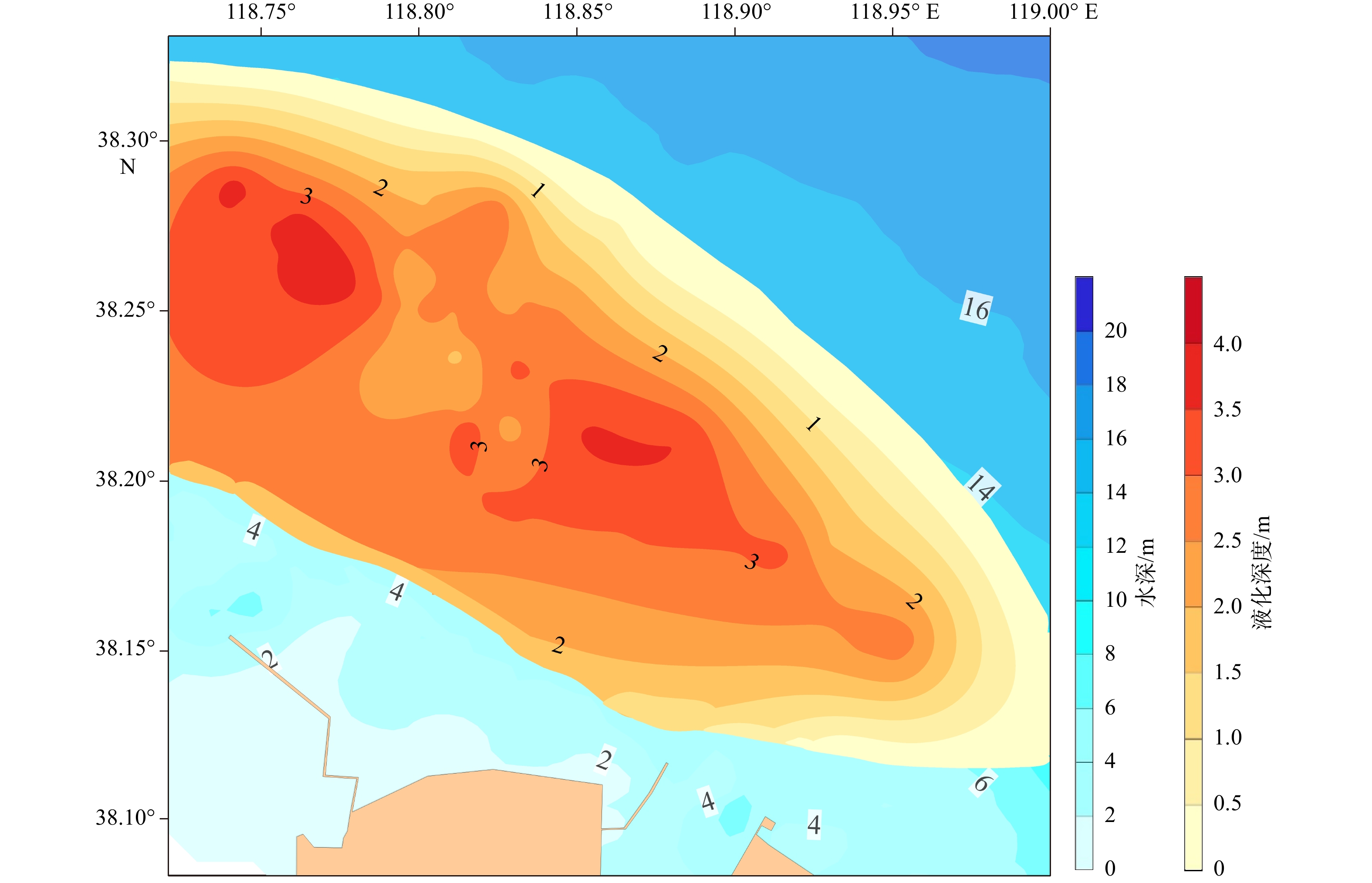
图 5 黄河口埕岛海域液化深度分布[22]
液化深度分布使用了50年一遇风浪条件下数据进行计算,并与物探测得的液化扰动层分布进行了对比验证
Fig. 5 Distribution of liquefaction depth in Chengdao sea area of the Yellow River Estuary[22]
The liquefaction depth distribution is calculated by using the data of 50 years return period wind and wave, and compared with the distribution of liquefaction disturbance layer measured by geophysical prospecting
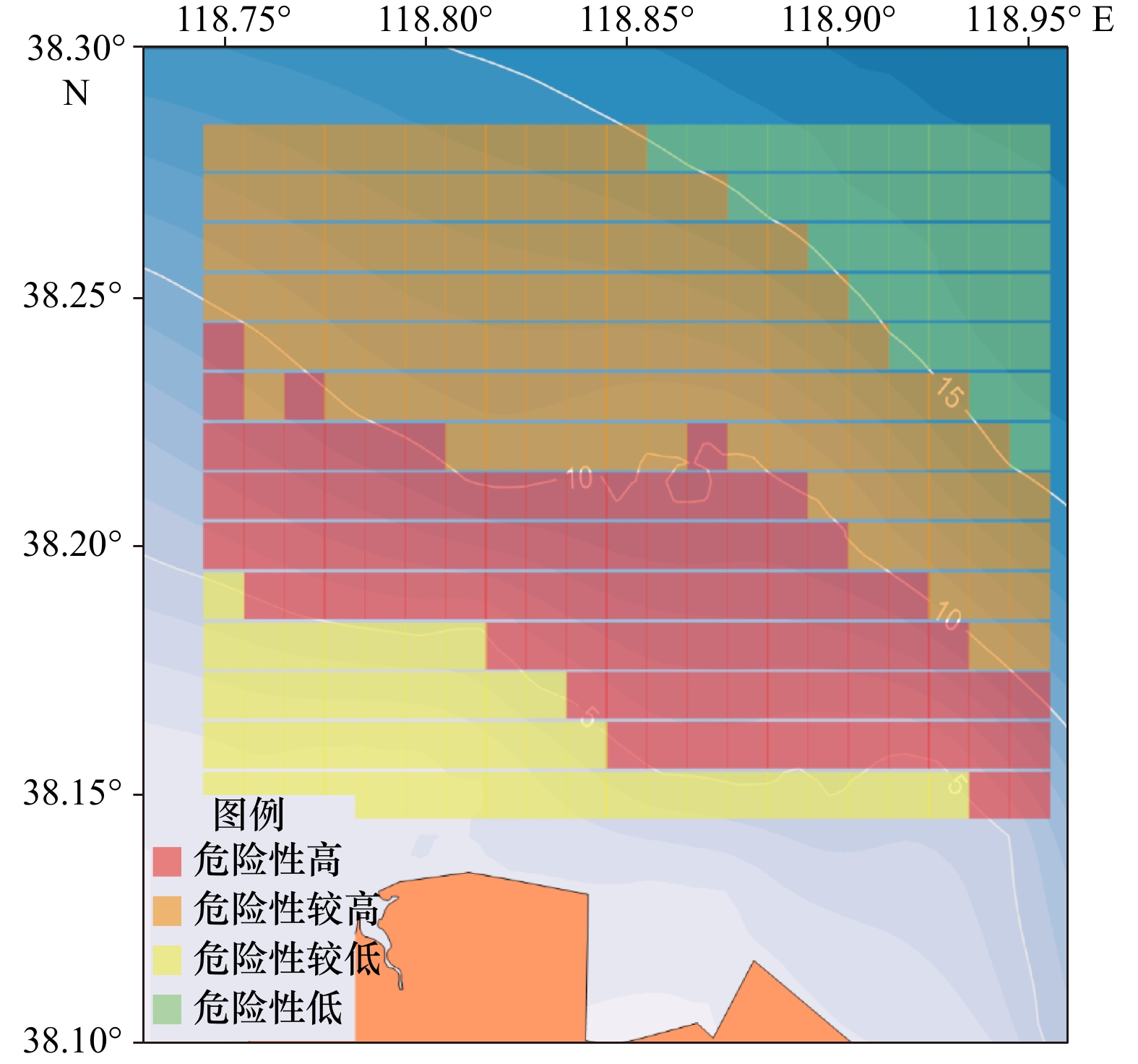
图 6 简化输入因子得到的海底滑坡危险性评价结果
Fig. 6 Risk assessment results of submarine landslides from simplified input factors
-
[1] Solheim A, Bryn P, Berg K, et al. Ormen Lange–An Integrated Study for Safe Field Development in the Storegga Submarine Slide Area[M]. San Diego: Elsevier, 2005. [2] Bea R G. How sea floor slides affect offshore structures[J]. Oil & Gas Journal, 1971, 69(48): 88−92. [3] Hsu S, Sibuet J. Flow of turbidity current viewed from failures of telecommunication cables[C]//International Conference on Seafloor Mapping for Geohazard Assessment. Ischia, Italy: American Geophysical Union, 2009. [4] Kawamura K, Laberg J S, Kanamatsu T. Potential tsunamigenic submarine landslides in active margins[J]. Marine Geology, 2014, 356: 44−49. doi: 10.1016/j.margeo.2014.03.007 [5] 刘锋. 南海北部陆坡天然气水合物分解引起的海底滑坡与环境风险评价[D]. 青岛: 中国科学院海洋研究所, 2010.Liu Feng. A safety evaluation for submarine slope instability of the northern South China Sea due to gas hydrae dissociation[D]. Qingdao: Institute of Oceanology, Chinese Academy of Sciences, 2010. [6] 胡光海. 东海陆坡海底滑坡识别及致滑因素影响研究[D]. 青岛: 中国海洋大学, 2010.Hu Guanghai. Identification of submarine landslides along the continental slope of the East China Sea and analysis of factors causing submarine landslides[D]. Qingdao: Ocean University of China, 2010. [7] Wang Weiwei, Wang Dawei, Wu Shiguo, et al. Submarine landslides on the north continental slope of the South China Sea[J]. Journal of Ocean University of China, 2018, 17(1): 83−100. doi: 10.1007/s11802-018-3491-0 [8] Ilstad T, De Blasio F V, Elverhøi A, et al. On the frontal dynamics and morphology of submarine debris flows[J]. Marine Geology, 2004, 213(1/4): 481−497. [9] El-Ramly H, Morgenstern N R, Cruden D M. Probabilistic slope stability analysis for practice[J]. Canadian Geotechnical Journal, 2002, 39(3): 665−683. doi: 10.1139/t02-034 [10] Griffiths D V, Lane P A. Slope stability analysis by finite elements[J]. Géotechnique, 1999, 49(3): 387−403. [11] Schwarz H U. Subaqueous Slope Failures: Experiments and Modern Occurences[M]. Stuttgart: Schweizerbart'sche Verlagsbuchhandlung, 1982. [12] Bradshaw A S, Tappin D R, Rugg D. The kinematics of a debris avalanche on the Sumatra margin[M]//Submarine Mass Movements and Their Consequences. Advances in Natural and Technological Hazards Research, Vol. 28. Dordrecht: Springer, 2010: 117–125. [13] Schofield A N. Use of centrifugal model testing to assess slope stability[J]. Canadian Geotechnical Journal, 1978, 15(1): 14−31. doi: 10.1139/t78-002 [14] 吴益平, 滕伟福, 李亚伟. 灰色–神经网络模型在滑坡变形预测中的应用[J]. 岩石力学与工程学报, 2007, 26(3): 632−636. doi: 10.3321/j.issn:1000-6915.2007.03.028Wu Yiping, Teng Weifu, Li Yawei. Application of grey-neural network model to landslide deformation prediction[J]. Chinese Journal of Rock Mechanics and Engineering, 2007, 26(3): 632−636. doi: 10.3321/j.issn:1000-6915.2007.03.028 [15] Marjanović M, Bajat B, Abolmasov B, et al. Machine learning and landslide assessment in a GIS environment[M]//GeoComputational Analysis and Modeling of Regional Systems. New York: Springer, 2018: 191–213. [16] Lun N K, Liew M S, Matori A N, et al. Recent developments in machine learning applications in landslide susceptibility mapping[J]. AIP Conference Proceedings, 2017, 1905: 040022. [17] Pham B T, Prakash I, Bui D T. Spatial prediction of landslides using a hybrid machine learning approach based on random subspace and classification and regression Trees[J]. Geomorphology, 2018, 303: 256−270. doi: 10.1016/j.geomorph.2017.12.008 [18] 孙永福, 胡光海, 宋玉鹏, 等. 近海海底地质灾害预测评价及防控关键技术研究[R]. 青岛: 自然资源部第一海洋研究所, 2016.Sun Yongfu, Hu Guanghai, Song Yupeng, et al. Study on the key technology of prediction, evaluation and prevention of offshore submarine geological hazards[R]. Qingdao: First Institute of Oceanograpy, Ministry of Natural Resources, 2016. [19] 杨作升, 陈卫民, 陈彰榕, 等. 黄河口水下滑坡体系[J]. 海洋与湖沼, 1994, 25(6): 573−581. doi: 10.3321/j.issn:0029-814X.1994.06.001Yang Zuosheng, Chen Weimin, Chen Zhangrong, et al. Subaqueous landslide system in the Huanghe River (Yellow River) delta[J]. Oceanologia et Limnologia Sinica, 1994, 25(6): 573−581. doi: 10.3321/j.issn:0029-814X.1994.06.001 [20] Prior D B, Yang Z S, Bornhold B D, et al. The subaqueous delta of the modern Huanghe (Yellow River)[J]. Geo-Marine Letters, 1986, 6(2): 67−75. doi: 10.1007/BF02281642 [21] 彭俊, 陈沈良, 陈一强, 等. 黄河三角洲侵蚀性岸段水下岸坡地质灾害及其空间分布[J]. 海洋通报, 2014, 33(1): 1−6. doi: 10.11840/j.issn.1001-6392.2014.01.001Peng Jun, Chen Shenliang, Chen Yiqiang, et al. Geological hazards and their spatial distribution in the subaqueous slope at the erosive coast of the Yellow River delta[J]. Marine Science Bulletin, 2014, 33(1): 1−6. doi: 10.11840/j.issn.1001-6392.2014.01.001 [22] 杜星. 黄河口海底粉土波致孔压精细观测及液化评判方法[D]. 青岛: 国家海洋局第一海洋研究所, 2016.Du Xing. Fine observation of wave-induced pore water pressure and liquefaction evaluation method of seabed silt in Yellow River Estuary[D]. Qingdao: The First Institute of Oceanography, State Oceanic Administration, 2016. -

 下载:
下载:

计量
- 文章访问数: 263
- HTML全文浏览量: 102
- PDF下载量: 22
- 被引次数: 0
