

A method of seafloor geographic entity boundary recognition based on D-P algorithm and optimal path
-
摘要: 海底地理实体的划定与命名是当前国际海洋权益领域的热点研究问题之一。然而,由于海底地理实体边界的量化界定技术缺乏,导致其界线确定不可避免地存在人为性,为此,本文提出了一种基于D-P算法和最优路径的海底地理实体边界划定方法。将高分辨率水深模型转换为二维水深矩阵,从横向与纵向进行剖面分析,采用极值点简化和D-P算法进行二次简化的方法,通过坡度变化定位和基部高程定位等基本条件综合判断,从而实现了单体海山的山体与其基部的自动划分;在此基础上,采用路径寻优的方法实现了连体型海山的自动分割。该方法在南海海底地理实体划定中进行了验证,取得了良好的应用效果。Abstract: The delimitation and naming of seabed geographic entities is one of the hot research issues in the field of international maritime rights and interests. However, due to the lack of quantitative definition technology for the boundaries of seabed geographic entities, the determination of the boundaries is inevitably artificial. For this reason, this paper proposes a method for the boundary delineation of seabed geographic entities based on the D-P algorithm and optimal path. Convert the high-resolution bathymetry model into a two-dimensional bathymetry matrix, conduct cross-section analysis from the horizontal and vertical directions, and use extreme point simplification and D-P algorithm for quadratic simplification. In this way, the automatic division of the mountain body and its base of a single seamount is realized; on this basis, the method of path optimization is used to realize the automatic segmentation of conjoined seamounts. The method has been verified in the delineation of seabed geographic entities in the South China Sea and achieved good application results.
-
Key words:
- geographical entity /
- foothills /
- D-P algorithm /
- path optimization /
- boundary recognition
-
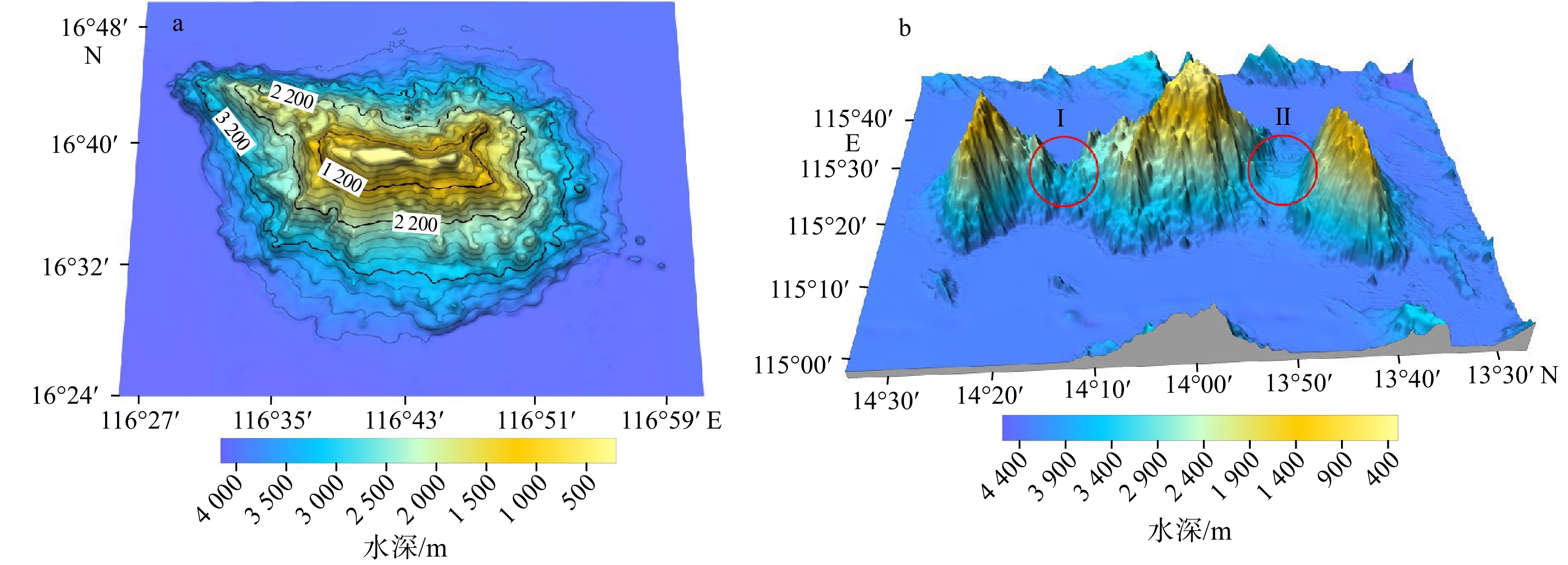
图 1 海山等高线示意图(a)和连体海山及垭口处地貌图(b)
Fig. 1 Schematic diagram of seamount contour (a) and geomorphic map of conjoined seamount and pass (b)
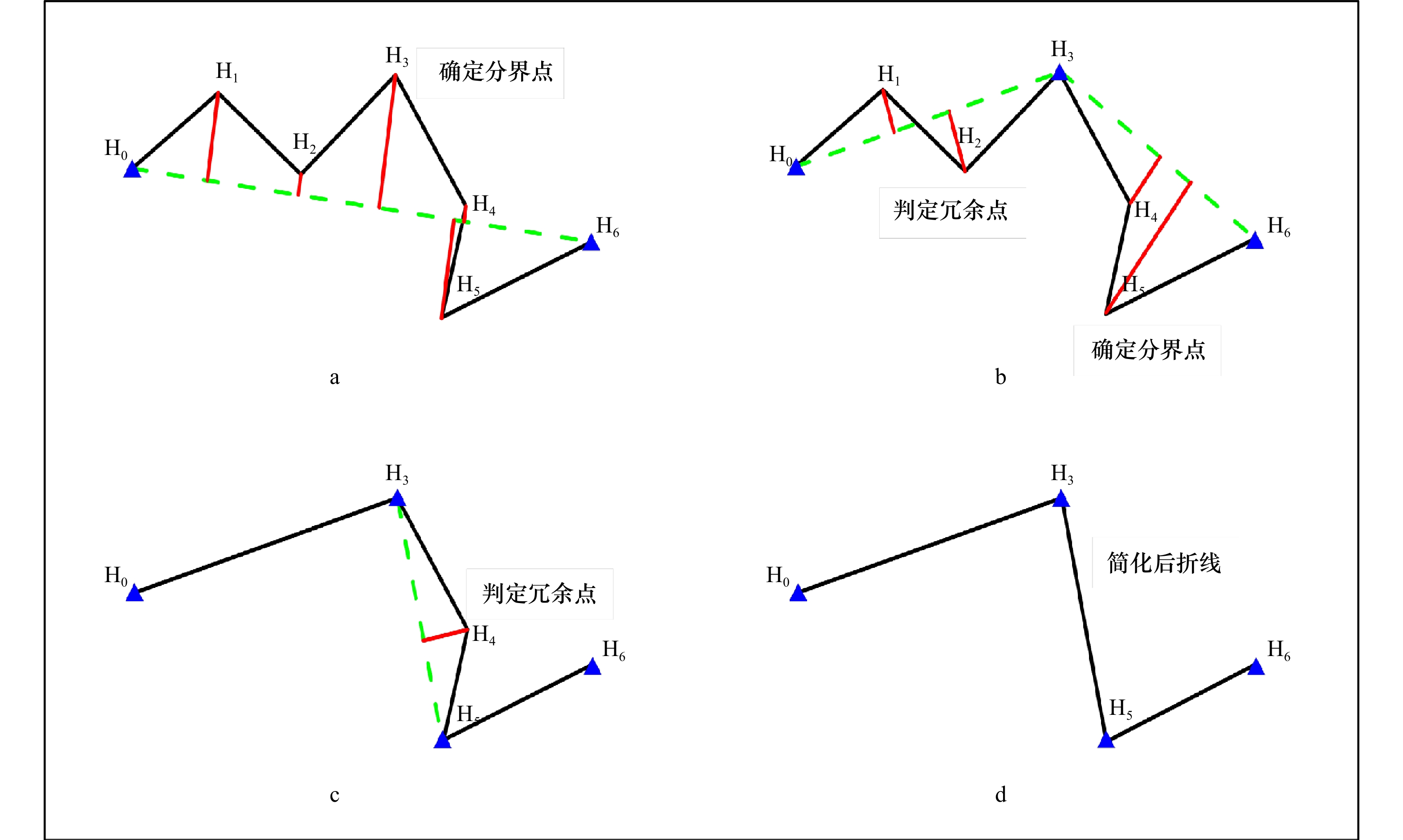
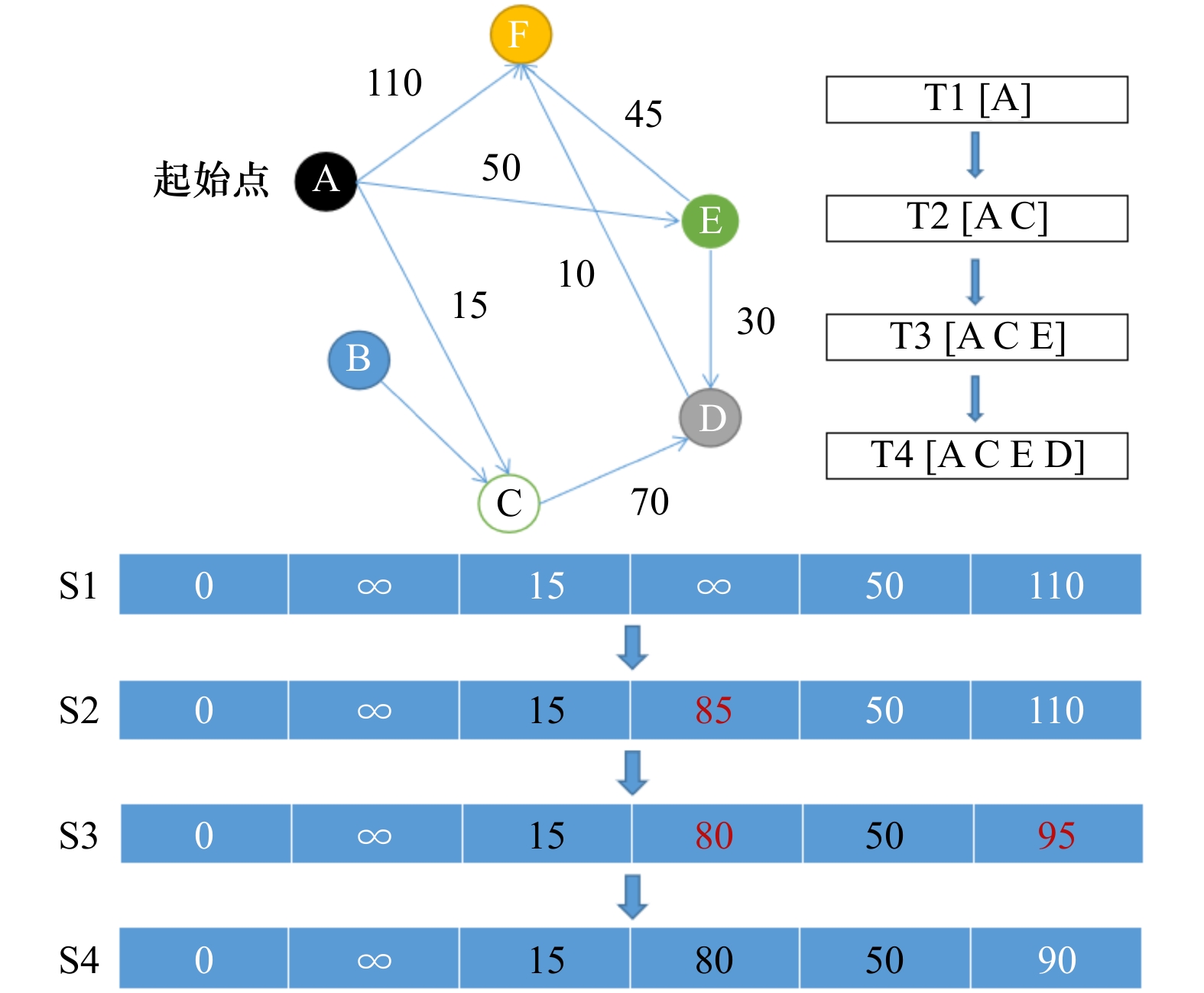
图 2 D-P算法流程示意图
图a,b,c和d为剔除冗余点步骤
Fig. 2 Flow diagram of D-P algorithm
Figures a, b, c and d are the steps of eliminating redundant points

图 5 典型地形剖面及识别山脚点过程图
Fig. 5 Typical topographic profile and process diagram of identifying mountain foot points
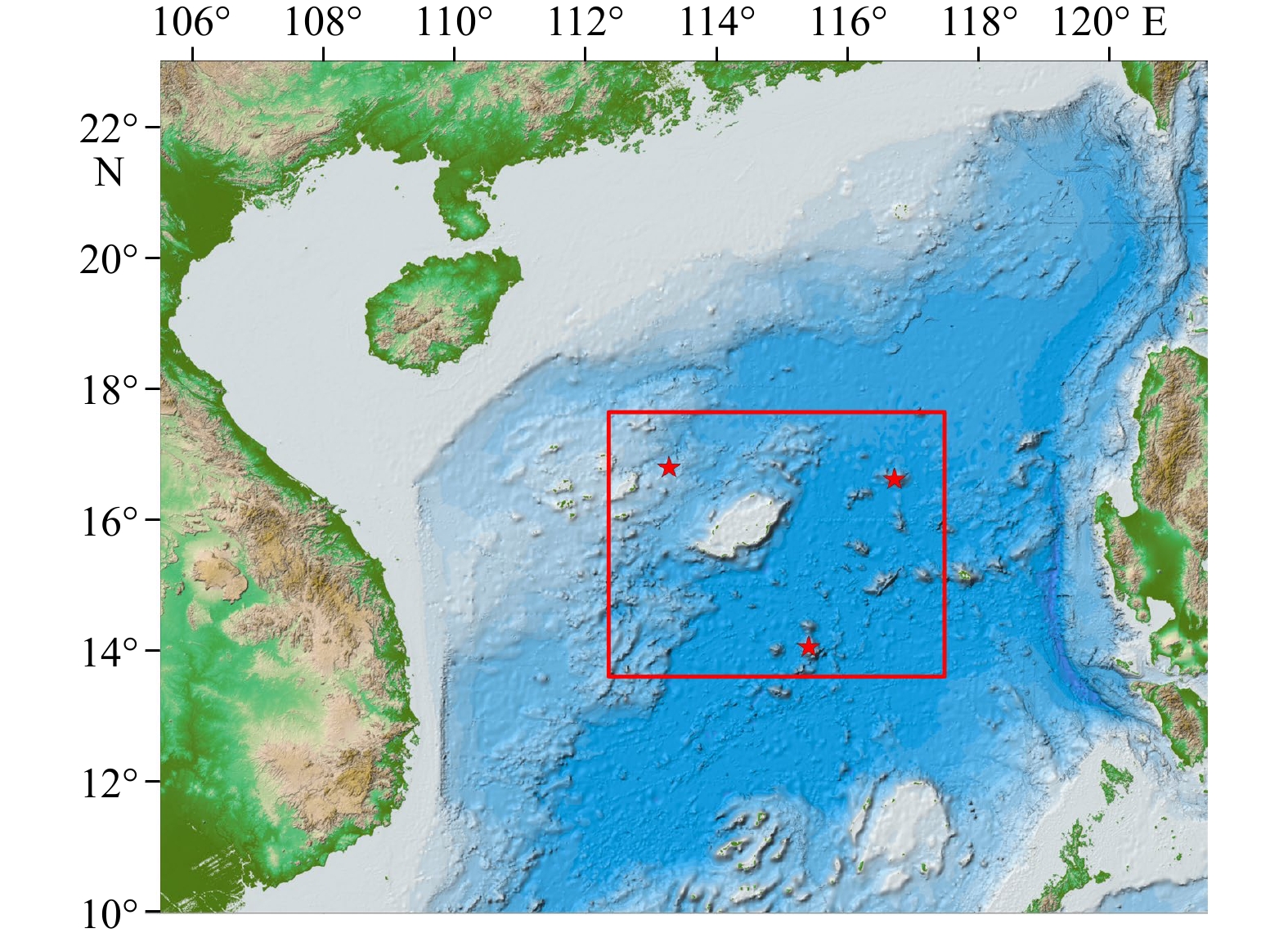
图 6 研究区域
图中五角星为选定的地理实体位置
Fig. 6 Study area
Where pentagram is the location of the selected geographical entity

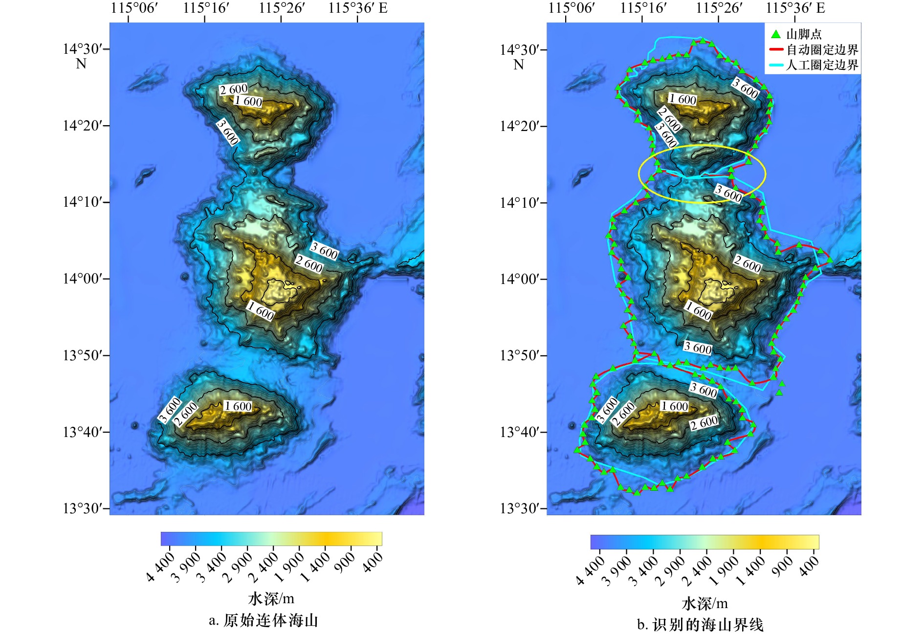
图 8 坐落于海盆区的典型海山界线划定示例
Fig. 8 Example of delimitation of typical seamount boundary located in the sea basin area
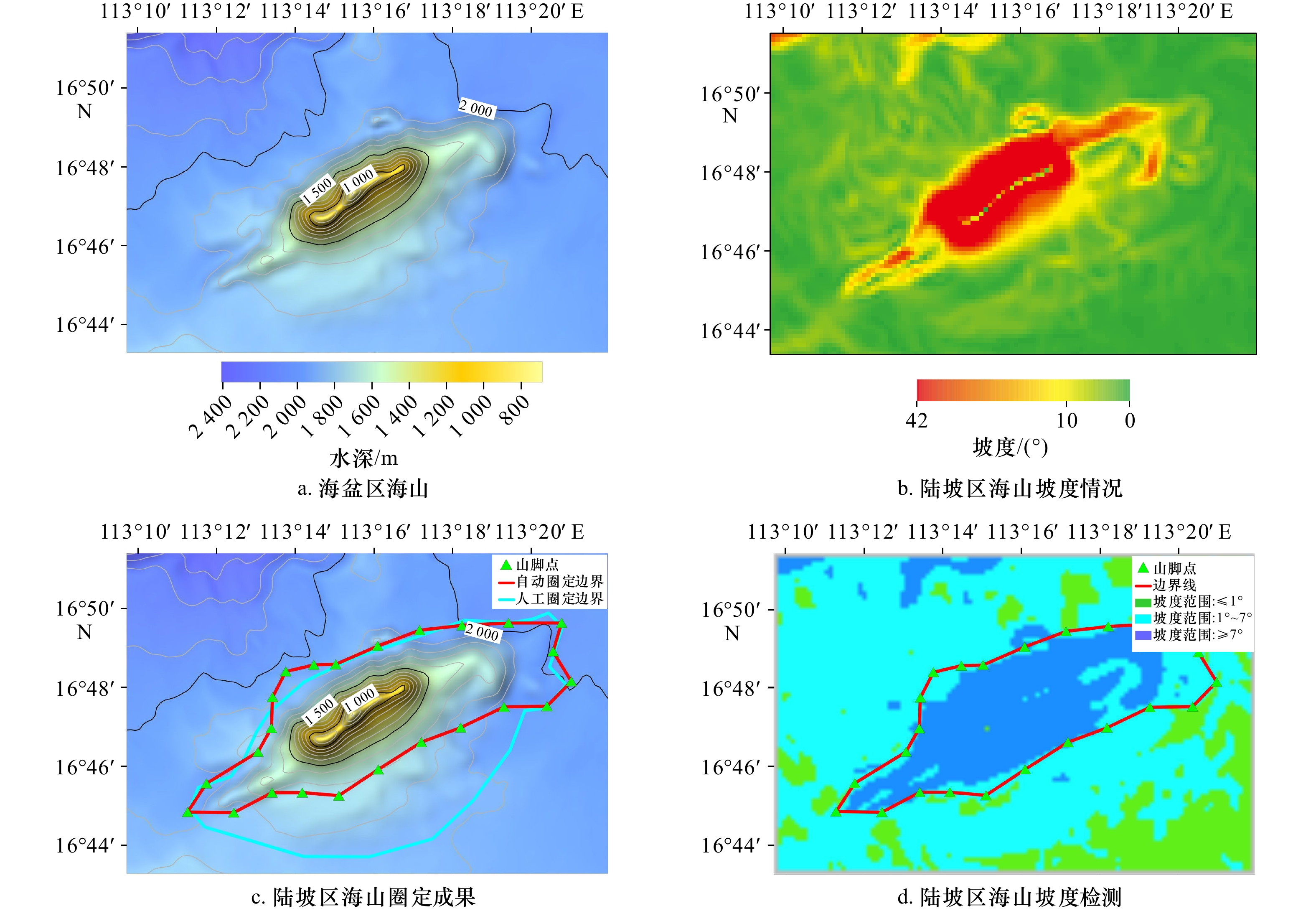
图 9 坐落于陆坡区的典型海山界线划定示例
Fig. 9 Example of delimitation of typical seamount boundary located in the land slope area
-
[1] 李四海, 邢喆, 樊妙, 等. 海底地名命名理论与技术方法[M]. 北京: 海洋出版社, 2015.Li Sihai, Xing Zhe, Fan Miao, et al. Naming Theory and Technical Methods of Seafloor Place Names[M]. Beijing: China Ocean Press, 2015. [2] 李四海, 李艳雯, 邢喆, 等. 海底地理实体命名关键技术研究[J]. 海洋测绘, 2013, 33(6): 42−44, 52.Li Sihai, Li Yanwen, Xing Zhe, et al. Research of the key technologies for naming undersea feature[J]. Hydrographic Surveying and Charting, 2013, 33(6): 42−44, 52. [3] 樊妙, 陈奎英, 邢喆, 等. 国际海底地形命名规则研究[J]. 海洋通报, 2012, 31(6): 661−666.Fan Miao, Chen Kuiying, Xing Zhe, et al. Study on the principles for undersea feature names of SCUFN[J]. Marine Science Bulletin, 2012, 31(6): 661−666. [4] 余童璐, 马行知. 海底地形命名的国际法分析——以SCUFN海底地形命名为出发点[J]. 五邑大学学报(社会科学版), 2018, 20(3): 66−69, 74.Yu Tonglu, Ma Xingzhi. An analysis of the international law on the naming of undersea Terrains[J]. Journal of Wuyi University (Social Sciences Edition), 2018, 20(3): 66−69, 74. [5] 黄文星, 朱本铎, 刘丽强, 等. 国际海底命名争端案例研究及其启示[J]. 地球科学进展, 2016, 31(1): 78−85.Huang Wenxing, Zhu Benduo, Liu Liqiang, et al. A case study of naming disputes of undersea features[J]. Advances in Earth Science, 2016, 31(1): 78−85. [6] 吴自银. 高分辨率海底地形地貌——探测处理理论与技术[M]. 北京: 科学出版社, 2017.Wu Ziyin. High Resolution Submarine Geomorphology—Theory and Technology for Surveying and Post-Processing[M]. Beijing: Science Press, 2017. [7] 吴自银. 高分辨率海底地形地貌——可视计算与科学应用[M]. 北京: 科学出版社, 2017.Wu Ziyin. High Resolution Submarine Geomorphology—Visual Computation and Scientific Applications[M]. Beijing: Science Press, 2017. [8] Sánchez-Guillamón O, Fernández-Salas L M, Vázquez J T, et al. Shape and size complexity of deep seafloor mounds on the Canary Basin (West to Canary Islands, Eastern Atlantic): a DEM-based geomorphometric analysis of domes and volcanoes[J]. Geosciences, 2018, 8(2): 37. doi: 10.3390/geosciences8020037 [9] 吴自银, 李家彪, 阳凡林, 等. 一种大陆坡脚点自动识别与综合判断方法[J]. 测绘学报, 2014, 43(2): 170−177.Wu Ziyin, Li Jiabiao, Yang Fanlin, et al. A method for automatic identification of the foot point of slope based on D-P algorithm[J]. Acta Geodaetica et Cartographica Sinica, 2014, 43(2): 170−177. [10] 周庆杰, 李西双, 徐元芹, 等. 一种基于水深梯度原理的海底滑坡快速识别方法——以南海北部陆坡白云深水区为例[J]. 海洋学报, 2017, 39(1): 138−147. doi: 10.3969/j.issn.0253-4193.2017.01.015Zhou Qingjie, Li Xishuang, Xu Yuanqin, et al. A rapid method to recognize submarine landslides based on the principle of water depth gradient: a case of Baiyun deep-water area, north slope of the South China Sea[J]. Haiyang Xuebao, 2017, 39(1): 138−147. doi: 10.3969/j.issn.0253-4193.2017.01.015 [11] 刘丽强, 朱本铎, 黄文星, 等. 海底地理实体命名专题图编制方法探讨[J]. 海洋地质前沿, 2018, 34(7): 71−76.Liu Liqiang, Zhu Benduo, Huang Wenxing, et al. Research on methods of drawing undersea feature names thematic map[J]. Marine Geology Frontier, 2018, 34(7): 71−76. [12] 栾坤祥. 南海北部海底峡谷识别方法构建与峡谷特征分析[D]. 青岛: 国家海洋局第一海洋研究所, 2017.Luan Kunxiang. The construction identification method of submarine canyon and characteristics analysis of northern South China Sea[D]. Qingdao: The First Institute of Oceanography, State Oceanic Administration, 2017. [13] 周洁琼, 吴自银, 赵荻能, 等. 海底沙波特征线的最优方向剖面自动识别方法[J]. 海洋学报, 2015, 37(7): 97−107. doi: 10.3969/j.issn.0253-4193.2015.07.010Zhou Jieqiong, Wu Ziyin, Zhao Dineng, et al. Automatic recognition of sand wave topographic features based on optimally-directional profiling method[J]. Haiyang Xuehao, 2015, 37(7): 97−107. doi: 10.3969/j.issn.0253-4193.2015.07.010 [14] 张庆余, 韩喜彬, 张志毅, 等. 海底峡谷的分类与识别研究进展[J]. 海洋测绘, 2019, 39(1): 11−13, 18. doi: 10.3969/j.issn.1671-3044.2019.01.003Zhang Qingyu, Han Xibin, Zhang Zhiyi, et al. Research progress on classification and recognition of submarine canyon[J]. Hydrographic Surveying and Charting, 2019, 39(1): 11−13, 18. doi: 10.3969/j.issn.1671-3044.2019.01.003 [15] 吴自银, 李家彪, 金翔龙, 等. 冲绳海槽海底地形地貌界限特征及影响因素[J]. 中国科学:地球科学, 2014, 57(8): 1885−1896. doi: 10.1007/s11430-013-4810-3Wu Ziyin, Li Jiabiao, Jin Xianglong, et al. Distribution, features, and influence factors of the submarine topographic boundaries of the Okinawa Trough[J]. Science China Earth Sciences, 2014, 57(8): 1885−1896. doi: 10.1007/s11430-013-4810-3 [16] Lecours V, Dolan M F J, Micallef A, et al. A review of marine geomorphometry, the quantitative study of the seafloor[J]. Hydrology and Earth System Sciences, 2016, 20(8): 3207−3244. doi: 10.5194/hess-20-3207-2016 [17] Pike R J. Geomorphometry-diversity in quantitative surface analysis[J]. Progress in Physical Geography: Earth and Environment, 2000, 24(1): 1−20. [18] 赵建虎. 现代海洋测绘[M]. 武汉: 武汉大学出版社, 2007.Zhao Jianhu. Modern Marine Surveying and Charting[M]. Wuhan: Wuhan University Press, 2007. [19] 阳凡林, 李家彪, 吴自银, 等. 浅水多波束勘测数据精细处理方法[J]. 测绘学报, 2008, 37(4): 444−450, 457.Yang Fanlin, Li Jiabiao, Wu Ziyin, et al. The methods of high quality post-processing for shallow multibeam data[J]. Acta Geodaetica et Cartographica Sinica, 2008, 37(4): 444−450, 457. [20] 张同伟, 唐嘉陵, 李正光, 等. 大深度近海底精细地形地貌探测技术[J]. 海洋测绘, 2018, 38(5): 20−24. doi: 10.3969/j.issn.1671-3044.2018.05.005Zhang Tongwei, Tang Jialing, Li Zhengguang, et al. Near seabed fine topography detection technology in deep sea[J]. Hydrographic Surveying and Charting, 2018, 38(5): 20−24. doi: 10.3969/j.issn.1671-3044.2018.05.005 [21] Cui Xiaodong, Xing Zhe, Yang Fanlin, et al. A method for multibeam seafloor terrain classification based on self-adaptive geographic classification unit[J]. Applied Acoustics, 2020, 157(1): 107029. [22] Huo Guanying, Wu Ziyin, Li Jiabiao. Underwater object classification in Sidescan sonar images using deep transfer learning and semisynthetic training data[J]. IEEE Access, 2020, 8: 47407−47418. doi: 10.1109/ACCESS.2020.2978880 [23] Wu Ziyin, Yang Fanlin, Tang Yong. High-Resolution Seafloor Survey and Applications[M]. Singapore: Springer & Science Press, 2021. [24] 吴自银, 温珍河. 中国近海海洋地质[M]. 北京: 科学出版社, 2021.Wu Ziyin, Wen Zhenhe. Marine Geology of China Sea[M]. Beijing: Science Press, 2021. [25] Harris P T, Macmillan-Lawler M, Rupp J, et al. Geomorphology of the oceans[J]. Marine Geology, 2014, 352: 4−24. doi: 10.1016/j.margeo.2014.01.011 [26] 肖飞, 张百平, 凌峰, 等. 基于DEM的地貌实体单元自动提取方法[J]. 地理研究, 2008, 27(2): 459−466. doi: 10.3321/j.issn:1000-0585.2008.02.023Xiao Fei, Zhang Baiping, Ling Feng, et al. DEM based auto-extraction of geomorphic units[J]. Geographical Research, 2008, 27(2): 459−466. doi: 10.3321/j.issn:1000-0585.2008.02.023 [27] 刘大维. 基于DEM的盆地标识与山脚线提取方法研究[D]. 西安: 西安建筑科技大学, 2016.Liu Dawei. The study on method of basins identification and foothill lines extraction based on DEM[D]. Xi’an University of Architecture and Technology, 2016. [28] 中国科学院地理研究所. 中国1∶1000000地貌图制图规范[M]. 北京: 科学出版社, 1987.Institute of Geography, Chinese Academy of Sciences. Specifications for China's 1∶1000000 Landform Mapping[M]. Beijing: Science Press, 1987. [29] 周成虎, 程维明, 钱金凯, 等. 中国陆地1: 100万数字地貌分类体系研究[J]. 地球信息科学, 2009, 11(6): 707−724.Zhou Chenghu, Cheng Weiming, Qian Jinkai, et al. Research on the classification system of digital land geomorphology of 1∶ 1000000 in China[J]. Journal of Geo-information Science, 2009, 11(6): 707−724. [30] 赵荻能, 吴自银, 周洁琼, 等. 声速剖面精简运算的改进D-P算法及其评估[J]. 测绘学报, 2014, 43(7): 681−689.Zhao Dineng, Wu Ziyin, Zhou Jieqiong, et al. A method for streamlining and assessing sound velocity profiles based on improved D-P algorithm[J]. Acta Geodaetica et Cartographica Sinica, 2014, 43(7): 681−689. [31] 鲍培明. 距离寻优中Dijkstra算法的优化[J]. 计算机研究与发展, 2001, 38(3): 307−311.Bao Peiming. A optimization algorithm based on Dijkstra's algorithm in search of shortcut[J]. Journal of Computer Research and Development, 2001, 38(3): 307−311. [32] 张福浩, 刘纪平, 李青元. 基于Dijkstra算法的一种最短路径优化算法[J]. 遥感信息, 2004(2): 38−41. doi: 10.3969/j.issn.1000-3177.2004.02.011Zhang Fuhao, Liu Jiping, Li Qingyuan. A new way of network analysis based on Dijkstra[J]. Remote Sensing Information, 2004(2): 38−41. doi: 10.3969/j.issn.1000-3177.2004.02.011 [33] Wu Ziyin, Zhao Dineng. Maps of Submarine Topographic and Undersea Feature Names of China's Surrounding Seas[M]. Beijing: SinoMap Press, 2021. [34] 吴自银, 赵荻能. 中国周边海域海底地形与地名图[M]. 北京: 中国地图出版社, 2021.Wu Ziyin, Zhao Dineng. Map of Submarine Topography and Place Names of China's Surrounding Seas[M]. Beijing: China Map Publishing House, 2021. -

 下载:
下载:


 点击查看大图
计量
- 文章访问数: 308
- HTML全文浏览量: 205
- PDF下载量: 26
- 被引次数: 0
